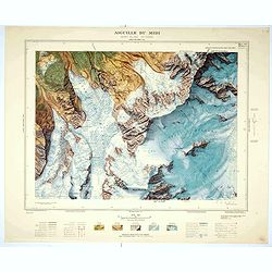
Aiguille du Midi - Mont Blanc N°1 Nord. |
||||||||||||||||||||
|
||||||||||||||||||||
|
|
||||||||||||||||||||
$1000 / ≈ €881This item is available for immediate sale! Questions before Buying ?
We are happy to answer your questions. Feel free to contact us if you have a question about this item.
Or do you like to be notified about newly added items? Add your name to our mailing list.
1000.00
|
Virtual Collection - Save and collect your favorite items in one place.
Unless logged in, the item is only saved for that session. If you want to save the items permanently, please Login first Learn more [+] |
|||||||||||||||||||
Description
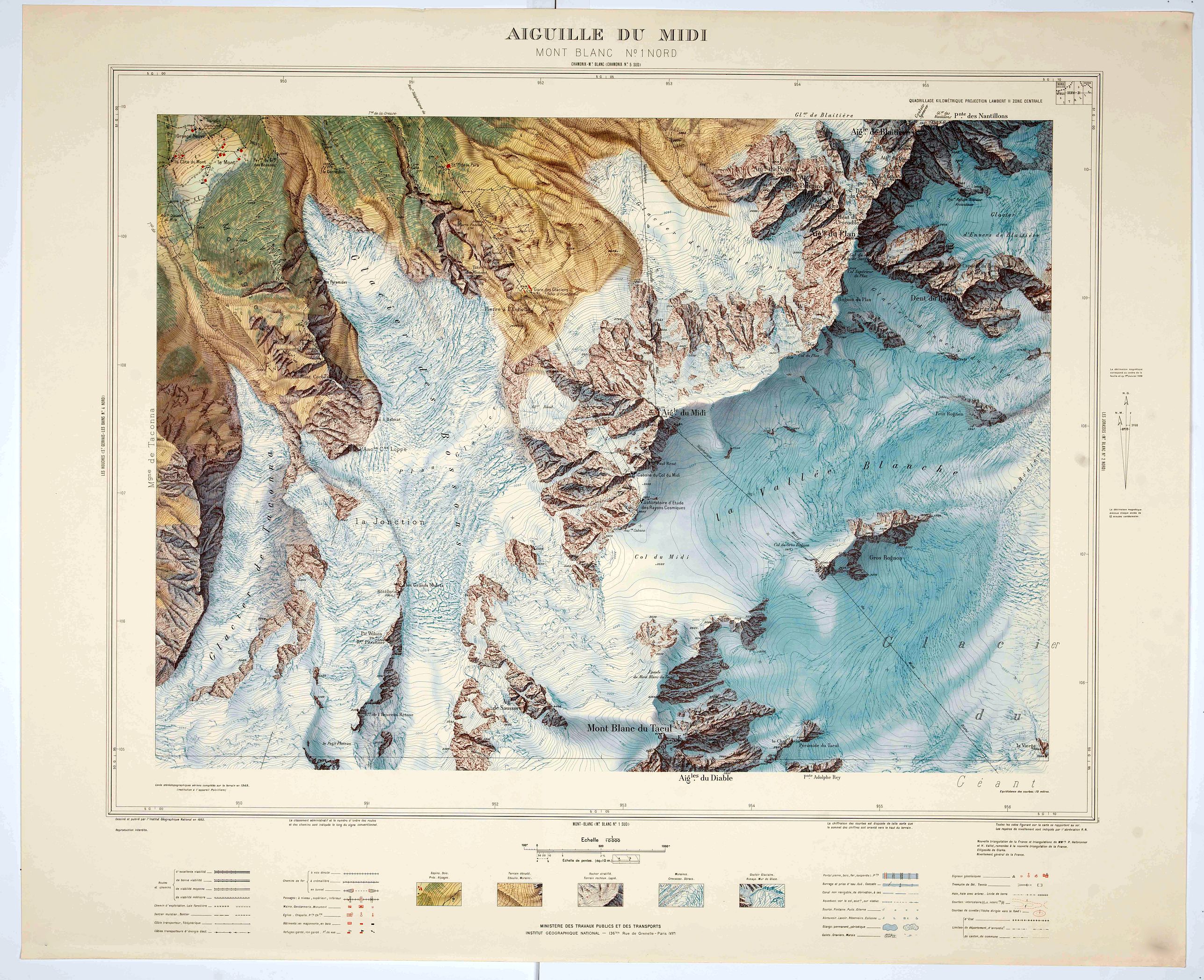
The rendering was based entirely on the Vallot and Helbronner triangulations, attached to the new triangulation and to the general levelling, and supplemented by pathways.
By the end of the 1930s, aerial surveys had definitively replaced land-based photographic surveys in the Alps, which were rapidly covered by aerial photographs. At the same time, the SGA included in its programme the survey of the Saint-Gervais, Chamonix and Mont-Blanc sheets of the Carte de France, which represented the entire French part of the Mont Blanc massif.
In June 1939, late enough to take advantage of the limited snow cover and good light conditions, the SGA's specialized squadron carried out aerial coverage of the region: in a Potez 540, the crew flew over the massif up to an altitude of 7,500 meters and took photos on an average scale of 1:22,000 with a 150 mm focal length lens. The SGA planned to draw up a 1:10,000 map from these surveys, so between 1941 and 1944, the images were reproduced at this scale on a Poivilliers type B stereotopograph, with contour lines drawn at ten-meter intervals, even in rocky areas. No preparatory work was carried out to provide a supplementary framework: the rendering was based entirely on the Vallot and Helbronner triangulations, linked to the new triangulation and the general levelling, and supplemented by photogrammetric trails.
The aerial coverage of Mont Blanc was a prestigious undertaking which served to establish the competence of the SGA. (Service Général des Armées), and Colonel Hurault confirmed this strictly prestigious nature when, in 1942, he decided to use this coverage for a special 1:10,000 map of the whole massif, presented in a particularly luxurious style (ten or eleven colours, double shading, etc.).
The delay caused by the war, which meant that it was not possible to complete the map in the field until the summer of 1949, and the gaps observed in the rendering, particularly due to the level of snow cover, which had made it difficult to draw some of the curves and identify the nature of the ground (glacier or rock), meant that two new aerial missions were needed to ensure the precision required to produce such a map. In 1948, oblique photographs of the summits were taken to help with the representation of the rock, and in September 1949, a new vertical coverage was carried out with minimal snow cover, at a scale of 1:20,0001469. Despite being discontinued in 1959, with only nine sheets published out of the twenty-four initially planned, the 1:10,000 map of the Mont Blanc massif established itself as the Institute's masterpiece, fulfilling the prestigious mission for which it had been designed, while at the same time representing the swan song of a certain approach to high mountain cartography.
FAQ - Guarantee - Shipping
Buying in the BuyNow Gallery
This item is available for immediate purchase when a "Add to Cart" or "Inquire Now" button is shown.
Items are sold in the EU margin scheme
Payments are accepted in Euros or US Dollars.
Authenticity Guarantee
 We provide professional descriptions, condition report (based on 45 years experience in the map business)
Paulus Swaen warrants the authenticity of our items and a certificate of authenticity is provided for each acquired lot.
Condition and Coloring
We indicate the condition of each item and use our unnique HiBCoR grading system in which four key items determine a map's value: Historical Importance, Beauty, Condition/Coloring and Rarity.
Color Key
We offer many maps in their original black and white condition. We do not systematically color-up maps to make them more sellable to the general public or buyer.
Copper engraved or wood block maps are always hand colored. Maps were initially colored for aesthetic reasons and to improve readability. Nowadays, it is becoming a challenge to find maps in their original colors and are therefor more valuable.
We use the following color keys in our catalog:
Original colors; mean that the colors have been applied around the time the map was issued.
Original o/l colors; means the map has only the borders colored at the time of publication.
Colored; If the colors are applied recently or at the end of the 20th century.
Read more about coloring of maps [+]
Shipping fee
A flat shipping fee of $ 30 is added to each shipment by DHL within Europe and North America. This covers : International Priority shipping, Packing and Insurance (up to the invoice amount).
Shipments to Asia are $ 40 and rest of the world $50
We charge only one shipping fee when you have been successful on multiple items or when you want to combine gallery and auction purchases.
Read more about invoicing and shipping
FAQ
Please have a look for more information about buying in the BuyNow gallery
Many answers are likely to find in the general help section.
Virtual Collection
![]()
With Virtual Collection you can collect all your favorite items in one place. It is free, and anyone can create his or her Virtual map collection.
Unless you are logged in, the item is only saved for this session. You have to be registed and logged-in if you want to save this item permanently to your Virtual Collection.
Read More[+]
Register here, it is free and you do not need a credit card.
Add this item to
Virtual Collection
or click the following link to see my Virtual Collection.
| High-Resolution Digital Image Download | |
|
Paulus Swaen maintains an archive of most of our high-resolution rare maps, prints, posters and medieval manuscript scans. We make them freely available for download and study. Read more about free image download |
Click this image for a free HR-image download. |
In accordance with the EU Consumer Rights Directive and habitually reside in the European Union you have the right to cancel the contract for the purchase of a lot, without giving any reason.
The cancellation period will expire 14 calendar days from the day after the date on which you or a third party (other than the carrier and indicated by you) acquires, physical possession of the lot. To exercise the right to cancel you must inform Paulus Swaen Europe bv, which is offering to sell the lot either as an agent for the seller or as the owner of the lot, of your decision to cancel this contract by a clear statement (e.g. a letter sent by post, or e-mail (amsterdam@swaen.com).
To meet the cancellation deadline, it is sufficient for you to send your communication concerning your exercise of the right to cancel before the cancellation period has expired.