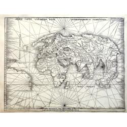
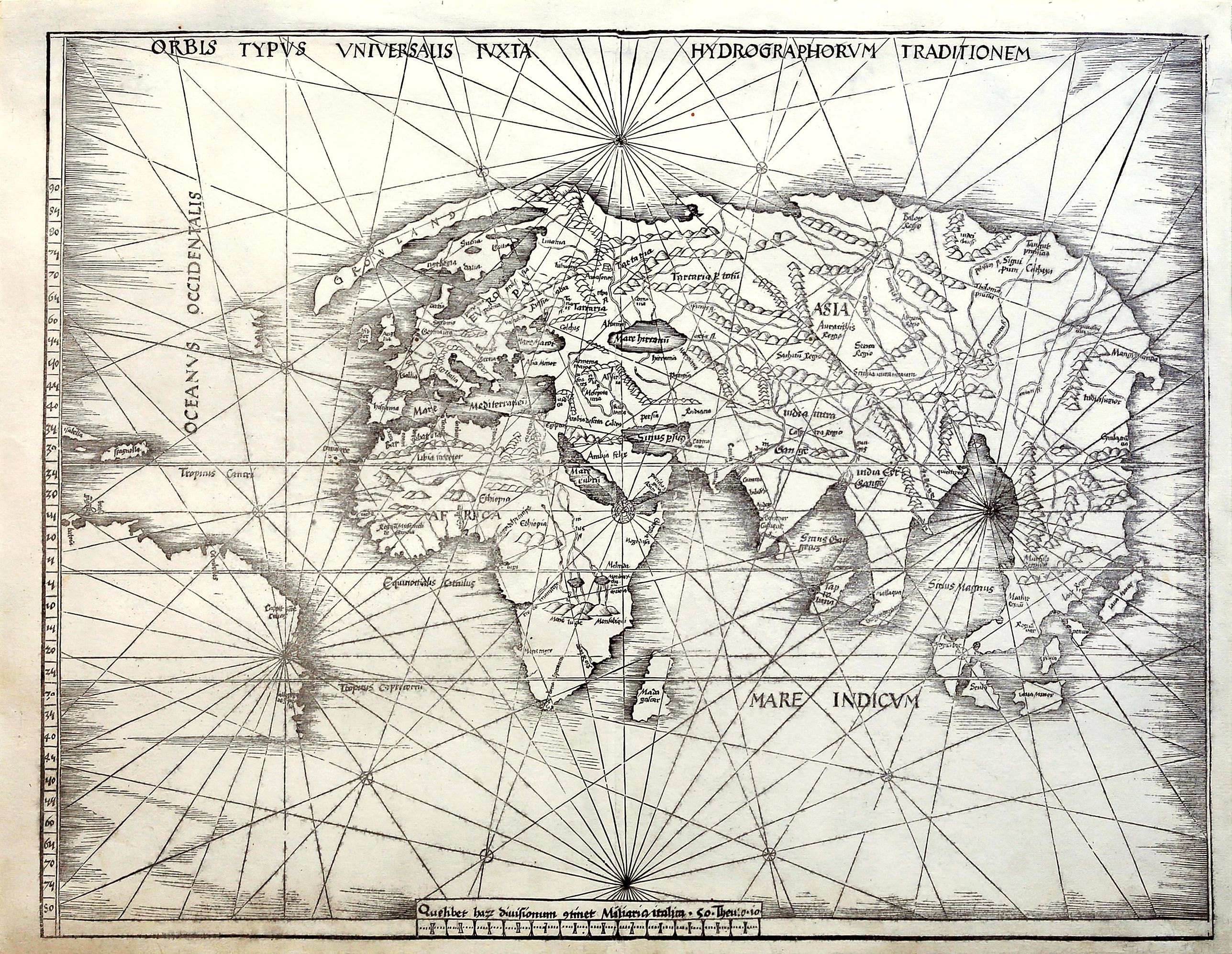
Orbis Typus Universalis Iuxta Hydrographorum Traditionem. |
||||||||||||||||||||
|
||||||||||||||||||||
|
|
||||||||||||||||||||
$75000 / ≈ €66071
This item is available for immediate sale
Feel free to contact us if you have a question about this item.
Or do you like to be notified about newly added items? Add your name to our mailing list.
75000.00
|
Virtual Collection - Save and collect your favorite items in one place.
Unless logged in, the item is only saved for that session. If you want to save the items permanently, please Login first Learn more [+] |
|||||||||||||||||||
Description
Double-page woodcut map of the world, with full margins. This so-called Admiral's Map; the first of two maps in Waldseemuller's atlas that relate to New World discoveries, and is referred to in the index as the 'Hydrographia sive Charta marina…', and in the 'Ad Lectorem' as the 'Charta Marina', where it is clearly stated that the geographical facts have been made known "through the most authentic voyages of a former Admiral of the most serene King of Portugal, Ferdinand, and those of other explorers" (The Admiral's Map What Was It? And Who the Admiral? Samuel Mc Coskry Stanton, Isis, Vol. 22, No. 2. (Feb., 1935), pp. 511-515).
The map was created for inclusion in the Strassburg 1513 edition of Ptolemy's Geographia; Gymnasium's Geographie Opus Novissima Traductione e Graecorum Archetypis, signaling the beginning of the section of twenty modern maps that were added to the twenty-seven Ptolemaic originals.
This world map gives a more accurate outline of eastern Asia than Ptolemy. It contains Greenland, which is attached to Europe, but only a tiny section of North America, meant to represent either Newfoundland or Labrador. With the Caribbean islands of Spagnolla [Haiti/Dominican Republic] and Isabella [Cuba], an unnamed small piece of land in the mid-Atlantic with an eastern coastline delineated, Greenland is depicted as an elongated peninsula attached to the north of Scandinavia, Great Britain shown as a single island, rhumb lines intersecting at 17 points. The coastline of South America is left unfinished, and only five place names are given.
The map was included in the Gymnasium's Geographie Opus Novissima Traductione e Graecorum Archetypis, printed in 1513 in Strasbourg, by Johannes Schott. Schott published a single further edition of the book in 1520. There were no alterations to this block.
The current map bears a watermark similar to Piquet 127481, manufactured in Como in 1519. This suggests the map was printed for the 1520 Strassburg edition, using the same woodblocks. Both editions are rare to the private market, with the 1520 edition being the rarest of the two.
Martin Waldseemüller (1470-1521) was a German scholar and cartographer. He studied under Gregor Reisch at the University of Freiburg and then moved to Basel in the late 1490s, where he met the printer Johannes Amerbach. In 1506 he moved to Saint-Dié in Lorraine, where Duke René II had established a humanist academy, the Gymnasium Vosagense. There, he read about Amerigo Vespucci's voyage to the Americas and Portuguese accounts of circumnavigating Africa.
Together, they proved that the Indian Ocean was not landlocked. He and his colleagues created a map that compared Vespucci's geographical information with Ptolemy's and explained why they had deviated from Ptolemy's precepts. That work, 'Cosmographia introductio', was published in 1507. It contains the first printed instance of the name 'America' being applied to the discoveries over the Atlantic: "The fourth part of the earth, we have decided to call Amerige, the land of Amerigo we might even say, or America because Amerigo discovered it".
Read more about Ptolemy and Waldseemüller.
Reference: Sabin 66478; Shirley, World 35.
FAQ - Guarantee - Shipping
Buying in the BuyNow Gallery
This item is available for immediate purchase when a "Add to Cart" or "Inquire Now" button is shown.
Items are sold in the EU margin scheme
Payments are accepted in Euros or US Dollars.
Authenticity Guarantee
 We provide professional descriptions, condition report (based on 45 years experience in the map business)
Paulus Swaen warrants the authenticity of our items and a certificate of authenticity is provided for each acquired lot.
Condition and Coloring
We indicate the condition of each item and use our unnique HiBCoR grading system in which four key items determine a map's value: Historical Importance, Beauty, Condition/Coloring and Rarity.
Color Key
We offer many maps in their original black and white condition. We do not systematically color-up maps to make them more sellable to the general public or buyer.
Copper engraved or wood block maps are always hand colored. Maps were initially colored for aesthetic reasons and to improve readability. Nowadays, it is becoming a challenge to find maps in their original colors and are therefor more valuable.
We use the following color keys in our catalog:
Original colors; mean that the colors have been applied around the time the map was issued.
Original o/l colors; means the map has only the borders colored at the time of publication.
Colored; If the colors are applied recently or at the end of the 20th century.
Read more about coloring of maps [+]
Shipping fee
A flat shipping fee of $ 30 is added to each shipment by DHL within Europe and North America. This covers : International Priority shipping, Packing and Insurance (up to the invoice amount).
Shipments to Asia are $ 40 and rest of the world $50
We charge only one shipping fee when you have been successful on multiple items or when you want to combine gallery and auction purchases.
Read more about invoicing and shipping
FAQ
Please have a look for more information about buying in the BuyNow gallery
Many answers are likely to find in the general help section.
Virtual Collection
![]()
With Virtual Collection you can collect all your favorite items in one place. It is free, and anyone can create his or her Virtual map collection.
Unless you are logged in, the item is only saved for this session. You have to be registed and logged-in if you want to save this item permanently to your Virtual Collection.
Read More[+]
Register here, it is free and you do not need a credit card.
Add this item to
Virtual Collection
or click the following link to see my Virtual Collection.
| High-Resolution Digital Image Download | |
|
Paulus Swaen maintains an archive of most of our high-resolution rare maps, prints, posters and medieval manuscript scans. We make them freely available for download and study. Read more about free image download |
Click this image for a free HR-image download. |
In accordance with the EU Consumer Rights Directive and habitually reside in the European Union you have the right to cancel the contract for the purchase of a lot, without giving any reason.
The cancellation period will expire 14 calendar days from the day after the date on which you or a third party (other than the carrier and indicated by you) acquires, physical possession of the lot. To exercise the right to cancel you must inform Paulus Swaen Europe bv, which is offering to sell the lot either as an agent for the seller or as the owner of the lot, of your decision to cancel this contract by a clear statement (e.g. a letter sent by post, or e-mail (amsterdam@swaen.com).
To meet the cancellation deadline, it is sufficient for you to send your communication concerning your exercise of the right to cancel before the cancellation period has expired.