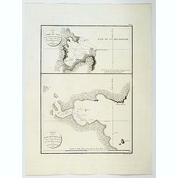
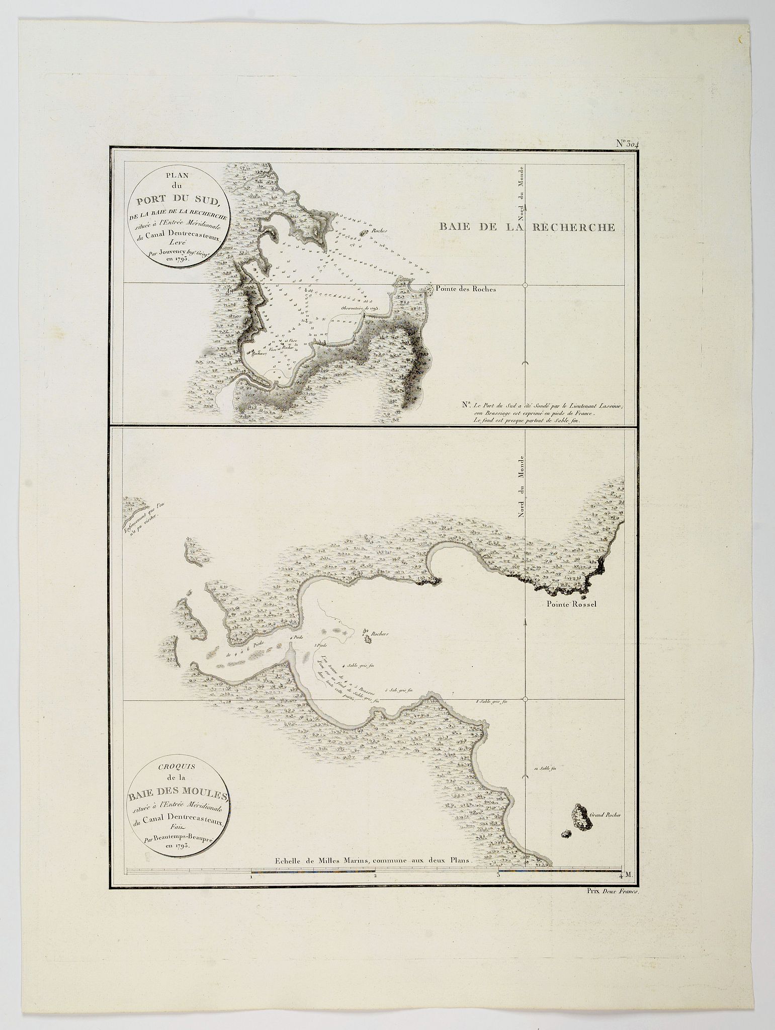
Plan du Port du Sud de la Baie de la Recherche / Croquis de la Baie des Moules. . . |
||||||||||||||||||||
|
||||||||||||||||||||
|
|
||||||||||||||||||||
$1500 / ≈ €1321This item is available for immediate sale! Questions before Buying ?
We are happy to answer your questions. Feel free to contact us if you have a question about this item.
Or do you like to be notified about newly added items? Add your name to our mailing list.
1500.00
|
Virtual Collection - Save and collect your favorite items in one place.
Unless logged in, the item is only saved for that session. If you want to save the items permanently, please Login first Learn more [+]
Watchers:
3
|
|||||||||||||||||||
Description
This is the edition of the extremely rare atlas Neptune des côtes orientales et du grand archipel d'Asie, published in 1807. The atlas was a supplement to the atlas series published by Hydrographic office and prepared by C.F Beautemps-Beaupré, who is now regarded as the father of modern French hydrography.
Although the map is cartographically similar, the maps for this edition are printed on very thick and larger paper and in the upper right corner N°.336 has been engraved and instead of Bouclet's name the words "Prix Deux Francs".
The D'Entrecasteaux channel is a body of water located between Bruny Island and the south-east of the mainland of Tasmania in Australia. The channel is the mouth for the estuaries of the Derwent and the Huon Rivers and empties into the Tasman Sea of the South Pacific Ocean. It was first sighted by Abel Tasman in 1642, and surveyed in 1792 by Bruni d'Entrecasteaux.
The chart is strong on physical detail, outlining trees, hills and rivers, but quite understandably, light on topographic detail, with only islands, capes and bays mentioned. With circular title cartouches, directional arrows, and some soundings.
The map is more commonly known from it's appearance in "Atlas du Voyage de Bruny Dentrecasteaux.", however the maps for the Neptune edition are printed on very thick and larger paper and in the upper right corner N°.304 has been added.
Very rare.
Beautemps-Beaupre sailed on the frigate 'La Recherche' under the command of Antoine Bruny d'Entrecasteaux. The purpose of the expedition was to find La Perouse, by following his route to New Holland (Australia), & also to map the coasts and islands they found. Beautemps-Beaupre's output was prolific, in just over 2 years he drew over 30 maps, at a rate vastly greater than any other expedition of his time.
Beautemps-Beaupré is regarded as the father of the modern hydrograpy.
Beautemps-Beaupré was born on August 6, 1766 in La Neuville-au-Pont (Marne). He was introduced to map drawing by his cousin Nicolas Buache, and he entered in 1780 as a hydrographer at the Depot of maps and plans of the French Navy. He was admitted as a pupil in his turn in 1783. There, he collaborated in the preparation of maps that La Pérouse carried on his journey.
He left in 1791 on the Search with admiral d'Entrecasteaux and remains absent five years. During this campaign, he developed entirely new ways of using charts under sail. Overcoming the compass variations, the remarkable points of the coast are shown in insets.
In 1779, Napoleon charged him with the hydrographic reconnaissance of the Dunkirk coast and various other works.
In 1816, Beautemps-Beaupré began the complete reconstruction of the hydrography of the coasts of France. Operations at sea will last 23 years. The French pilot, completed in 1844, the result of his work, was admired by the entire maritime world.
He was a Knight of Saint-Louis, Knight of Saint Michel, Grand Officer of the Legion of Honor, he died in 1854, at the age of 88 years. He left to his companions the memory of a simple man, modest, judicious, courageous and good. Leading the way in the work, training his engineers, Beautemps-Beaupré has earned the title of father of the hydrography that has been awarded.
More about C.F. Beautemps-Beaupré and mapping of Australia." [+]
Reference: Tooley, The mapping of Australia and Antartica, 169, pag. 311.
FAQ - Guarantee - Shipping
Buying in the BuyNow Gallery
This item is available for immediate purchase when a "Add to Cart" or "Inquire Now" button is shown.
Items are sold in the EU margin scheme
Payments are accepted in Euros or US Dollars.
Authenticity Guarantee
 We provide professional descriptions, condition report (based on 45 years experience in the map business)
Paulus Swaen warrants the authenticity of our items and a certificate of authenticity is provided for each acquired lot.
Condition and Coloring
We indicate the condition of each item and use our unnique HiBCoR grading system in which four key items determine a map's value: Historical Importance, Beauty, Condition/Coloring and Rarity.
Color Key
We offer many maps in their original black and white condition. We do not systematically color-up maps to make them more sellable to the general public or buyer.
Copper engraved or wood block maps are always hand colored. Maps were initially colored for aesthetic reasons and to improve readability. Nowadays, it is becoming a challenge to find maps in their original colors and are therefor more valuable.
We use the following color keys in our catalog:
Original colors; mean that the colors have been applied around the time the map was issued.
Original o/l colors; means the map has only the borders colored at the time of publication.
Colored; If the colors are applied recently or at the end of the 20th century.
Read more about coloring of maps [+]
Shipping fee
A flat shipping fee of $ 30 is added to each shipment by DHL within Europe and North America. This covers : International Priority shipping, Packing and Insurance (up to the invoice amount).
Shipments to Asia are $ 40 and rest of the world $50
We charge only one shipping fee when you have been successful on multiple items or when you want to combine gallery and auction purchases.
Read more about invoicing and shipping
FAQ
Please have a look for more information about buying in the BuyNow gallery
Many answers are likely to find in the general help section.
Virtual Collection
![]()
With Virtual Collection you can collect all your favorite items in one place. It is free, and anyone can create his or her Virtual map collection.
Unless you are logged in, the item is only saved for this session. You have to be registed and logged-in if you want to save this item permanently to your Virtual Collection.
Read More[+]
Register here, it is free and you do not need a credit card.
Add this item to
Virtual Collection
or click the following link to see my Virtual Collection.
| High-Resolution Digital Image Download | |
|
Paulus Swaen maintains an archive of most of our high-resolution rare maps, prints, posters and medieval manuscript scans. We make them freely available for download and study. Read more about free image download |
Click this image for a free HR-image download. |
In accordance with the EU Consumer Rights Directive and habitually reside in the European Union you have the right to cancel the contract for the purchase of a lot, without giving any reason.
The cancellation period will expire 14 calendar days from the day after the date on which you or a third party (other than the carrier and indicated by you) acquires, physical possession of the lot. To exercise the right to cancel you must inform Paulus Swaen Europe bv, which is offering to sell the lot either as an agent for the seller or as the owner of the lot, of your decision to cancel this contract by a clear statement (e.g. a letter sent by post, or e-mail (amsterdam@swaen.com).
To meet the cancellation deadline, it is sufficient for you to send your communication concerning your exercise of the right to cancel before the cancellation period has expired.