


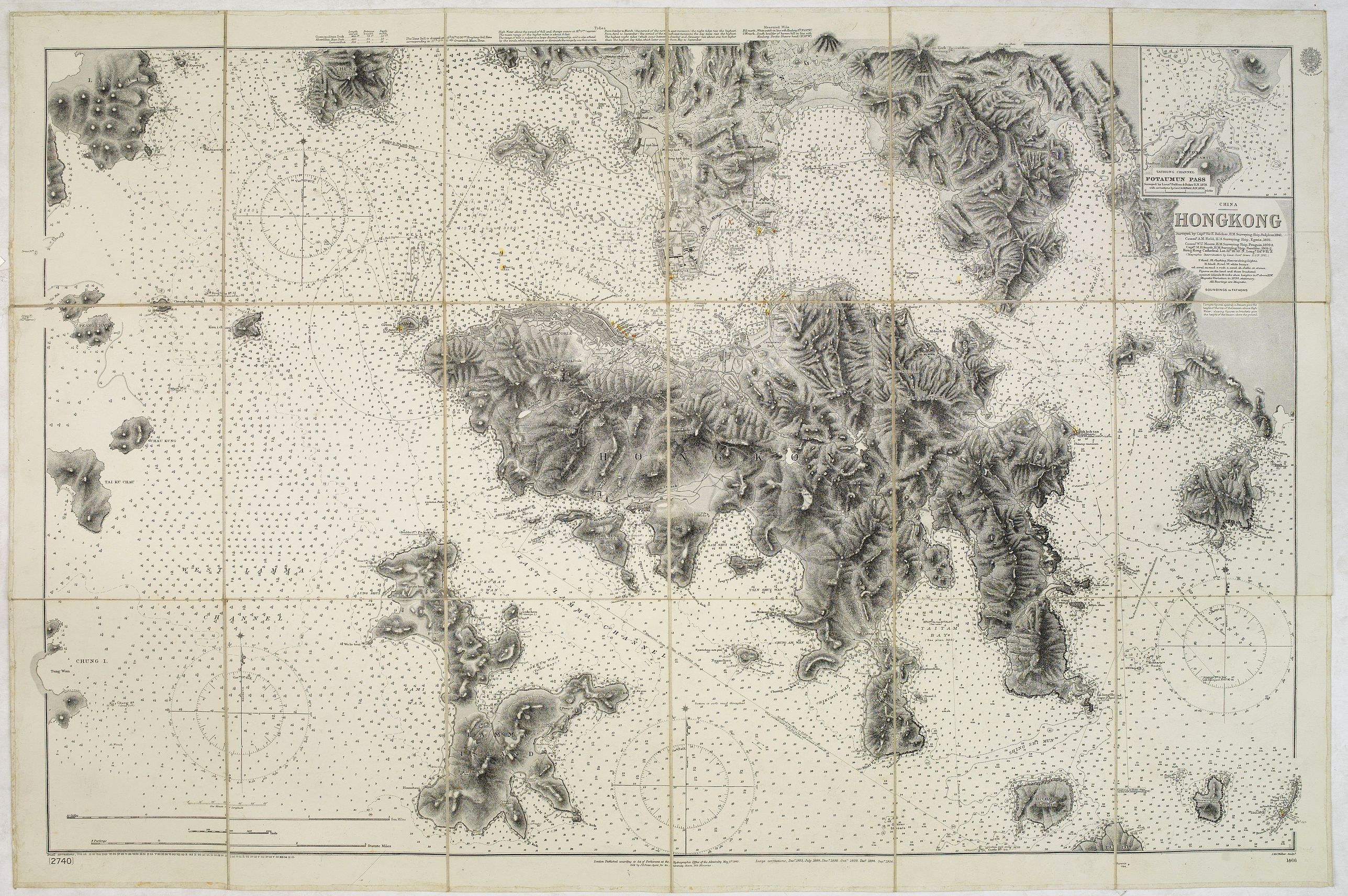
COLLECTION OF HONG KONG MAPS, BOOKS & FLYERS. Including CHINA - HONGKONG surveyed by Captn. Sir Edward Belcher, in H.M.S. Sulphur 1841. Corrected to 1901. |
||||||||||||||||||||
|
||||||||||||||||||||
|
|
||||||||||||||||||||
$25000 / ≈ €22024This item is available for immediate sale! Questions before Buying ?
We are happy to answer your questions. Feel free to contact us if you have a question about this item.
Or do you like to be notified about newly added items? Add your name to our mailing list.
25000.00
|
Virtual Collection - Save and collect your favorite items in one place.
Unless logged in, the item is only saved for that session. If you want to save the items permanently, please Login first Learn more [+]
Watchers:
15
|
|||||||||||||||||||
Description
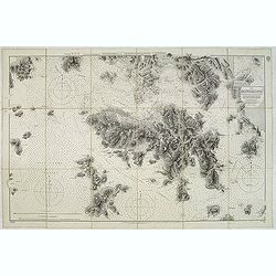
Belcher entered the royal navy in 1812. In 1825 he accompanied Frederick William Beechey's expedition to the Pacific as a surveyor on board the bomb vessel HMS Sulphur. In 1841 the Commander Belcher landed on Possession Point at the north shore of Hong Kong Island and made the first British survey of Hong Kong harbor.
- WA (SUNG SUNG CHUN) Hong Kong. Hong Kong, Tungar Printing co, Ltd, ca. 1924. In original printed colors. 450x635mm. color printed map, with remains of old folds, some pin point holes on crossings of folds. Signed (possibly stamped) lower left. Very good condition.
A topographical map of Hong Kong, Lamma Island, Po Toi, the Kowloon Peninsula, and the eastern tip of Lantau Island, on a scale of 1 3/8 inches to a mile, titled above, text in English and Chinese, large compass rose lower left, color-printed map by the South China Lithographic Press, Hong Kong, Saiyingpun School, c.1924.
- MAYERS, Fred / Dennys, N.B. The Treaty Ports of China and Japan. A Complete Guide to the Open Ports of Those countries, together with Peking, Yedo, Hong Kong and Macao forming a Guide Book & Vade Mecum for Travellers, Merchants, and Residents in General. Trubner and Co. / A. Shortrede and Co. London / Hong Kong. 1867. 28 folding maps, complete as called for in the Table of Contents "List of Maps etc," indices, appendices, viii+668+26pp, cloth-covered boards with leather corners and gilt spine. First and only edition.
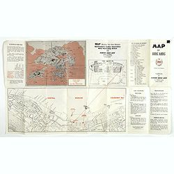
- EDUCATIONAL SUPPLEMENTS CORP. (Hong Kong) Hong Kong. New York, 1968. In printed colors. 560x735mm. Folding map in very good condition.
A large educational map for the islands showing the major towns and place names as it was. A simple timeline at the bottom starts with migrants arriving from north China sometime around 2000 B.C., and ends in 1961 with "Population explodes to more than 3,000,000" , its population today well doubles that.
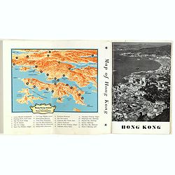
Among many others.

FAQ - Guarantee - Shipping
Buying in the BuyNow Gallery
This item is available for immediate purchase when a "Add to Cart" or "Inquire Now" button is shown.
Items are sold in the EU margin scheme
Payments are accepted in Euros or US Dollars.
Authenticity Guarantee
 We provide professional descriptions, condition report (based on 45 years experience in the map business)
Paulus Swaen warrants the authenticity of our items and a certificate of authenticity is provided for each acquired lot.
Condition and Coloring
We indicate the condition of each item and use our unnique HiBCoR grading system in which four key items determine a map's value: Historical Importance, Beauty, Condition/Coloring and Rarity.
Color Key
We offer many maps in their original black and white condition. We do not systematically color-up maps to make them more sellable to the general public or buyer.
Copper engraved or wood block maps are always hand colored. Maps were initially colored for aesthetic reasons and to improve readability. Nowadays, it is becoming a challenge to find maps in their original colors and are therefor more valuable.
We use the following color keys in our catalog:
Original colors; mean that the colors have been applied around the time the map was issued.
Original o/l colors; means the map has only the borders colored at the time of publication.
Colored; If the colors are applied recently or at the end of the 20th century.
Read more about coloring of maps [+]
Shipping fee
A flat shipping fee of $ 30 is added to each shipment by DHL within Europe and North America. This covers : International Priority shipping, Packing and Insurance (up to the invoice amount).
Shipments to Asia are $ 40 and rest of the world $50
We charge only one shipping fee when you have been successful on multiple items or when you want to combine gallery and auction purchases.
Read more about invoicing and shipping
FAQ
Please have a look for more information about buying in the BuyNow gallery
Many answers are likely to find in the general help section.
Virtual Collection
![]()
With Virtual Collection you can collect all your favorite items in one place. It is free, and anyone can create his or her Virtual map collection.
Unless you are logged in, the item is only saved for this session. You have to be registed and logged-in if you want to save this item permanently to your Virtual Collection.
Read More[+]
Register here, it is free and you do not need a credit card.
Add this item to
Virtual Collection
or click the following link to see my Virtual Collection.
| High-Resolution Digital Image Download | |
|
Paulus Swaen maintains an archive of most of our high-resolution rare maps, prints, posters and medieval manuscript scans. We make them freely available for download and study. Read more about free image download |
Click this image for a free HR-image download. |


In accordance with the EU Consumer Rights Directive and habitually reside in the European Union you have the right to cancel the contract for the purchase of a lot, without giving any reason.
The cancellation period will expire 14 calendar days from the day after the date on which you or a third party (other than the carrier and indicated by you) acquires, physical possession of the lot. To exercise the right to cancel you must inform Paulus Swaen Europe bv, which is offering to sell the lot either as an agent for the seller or as the owner of the lot, of your decision to cancel this contract by a clear statement (e.g. a letter sent by post, or e-mail (amsterdam@swaen.com).
To meet the cancellation deadline, it is sufficient for you to send your communication concerning your exercise of the right to cancel before the cancellation period has expired.
![Tabula XII - Asiae [Taprobana Ins - Ceylon/Sri Lanka]](/uploads/cache/40249-250x250.jpg)
![[Title page from Theatrum orbis Terrarum, with past-on]](/uploads/cache/43860-250x250.jpg)