Subscribe to be notified if similar examples become available.
Cape of Good Hope. |
||||||||||||||||||||
|
||||||||||||||||||||
|
|
||||||||||||||||||||
|
Selling price: $275
Sold in 2017 Missed this item! Be the first to get notified about our newly added listings. Add your name to our mailing list. |
Virtual Collection - Save and collect your favorite items in one place.
Unless logged in, the item is only saved for that session. If you want to save the items permanently, please Login first Learn more [+] |
|||||||||||||||||||
Description
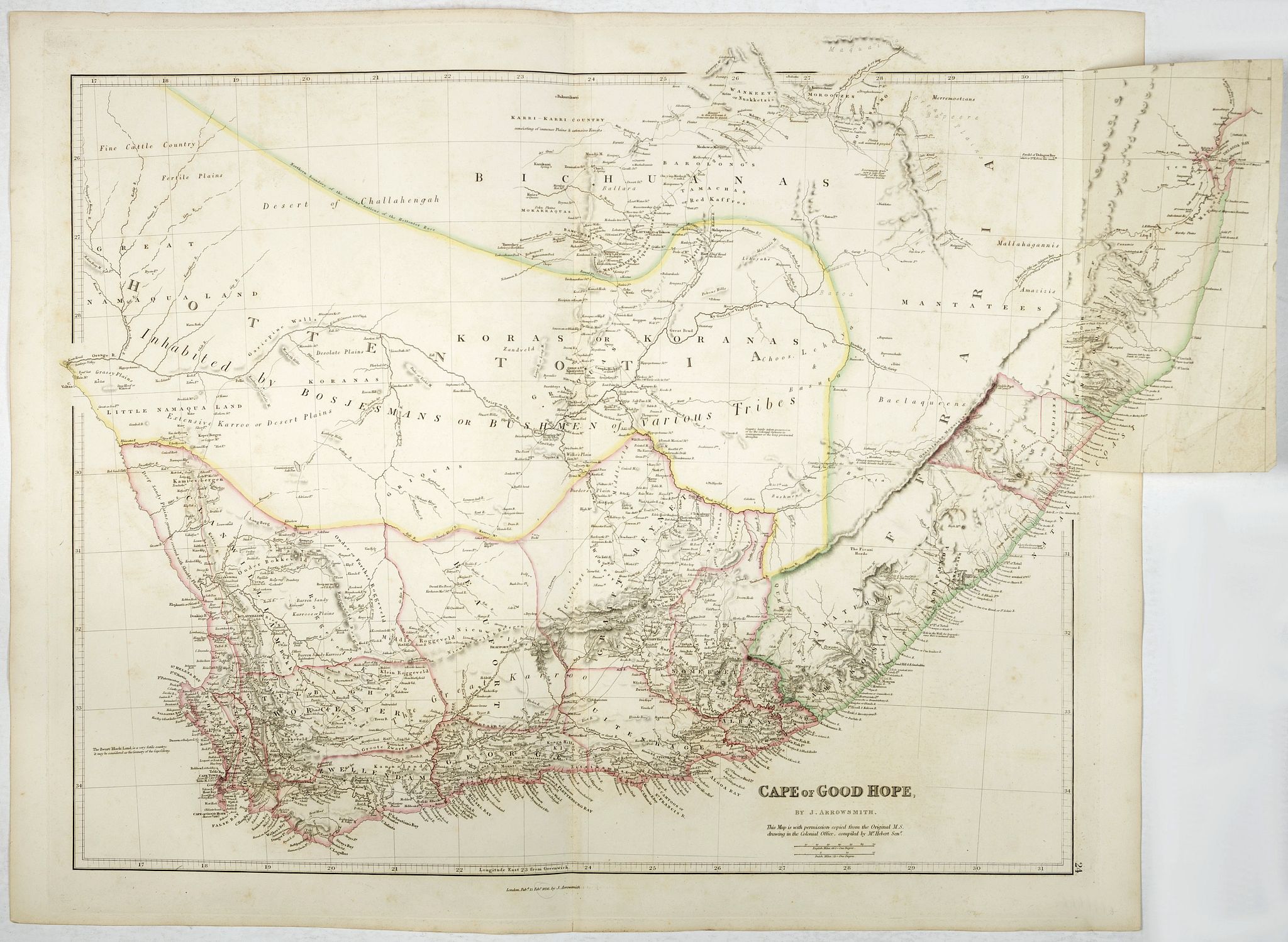
It is one of the very few maps to record a very short-lived toponym: "K.GEO Cataract IV 400 ft. high" - the traveller George Thompson was led to the Augrabies Falls by the Koranna people in 1826, his name of King George IV Falls did not take on, but the original Khoi name Aukoerebis, which means ‘place of great noise’, did.
The map records that the Zwart Land, in today’s Western Cape, is ‘very fertile country: it may be considered the Granary of the Cape Colony'. Along the Zeekoei River, a southern tributary of the Orange River, Arrowsmith shows the location of Van Plettenberg’s Beacon (remnants now at the Iziko Museum), the north-east corner of the Cape in the 1770s, but subsequently replaced by the Orange River, as depicted on the map.
The map displays eleven magisterial districts and provides historically important documentation of travel and exploration in South Africa. It shows the routes taken not only by Thompson, who mostly followed well worn tracks, but also those of more pioneering travellers such as Burchell, Cowie and Green & Capt Gardiner, Bain and Biddulph.
This state and subsequent updates of this map provide one of the best cartographic records of the expansion of the Boer settlements to the north and east of the Cape Colony. For example, Arrowsmith indicates on the map, near Phillipolis, then just a missionary station, that this ‘country lately taken possession of by the Colonial farmers because of the protracted drought.’
The map shows the approximate location of indigenous groups, assigning a large area to the ‘Koras or Koranas’, a group that now has been absorbed into the Griqua and other groups. The map shows the tracks of William Burchell who described and drew Kora people and recorded some of their language. Durban is shown in the Colony of Victoria. The Hemel en Aarde or Leper's Institute of which Dr James Barry had been critical.
John Arrowsmith (1790-1873) was from a family of London based cartographers and publishers, and was a founding member of the Royal Geographical Society. His "London Atlas," known for its understated elegance, is considered one of the first truly "modern" atlases of the nineteenth century. John Arrowsmith was a nephew of the patriarch, Aaron, and worked out of London. He was one of the foremost cartographers of the era and, like his uncle, he aspired to design maps that were up to date.
More about J.Arrowsmith [+]
Reference: Tooley pp 18 - 19 in which he details changes since the 1834 edition.
FAQ - Guarantee - Shipping
Buying in the BuyNow Gallery
This item is available for immediate purchase when a "Add to Cart" or "Inquire Now" button is shown.
Items are sold in the EU margin scheme
Payments are accepted in Euros or US Dollars.
Authenticity Guarantee
 We provide professional descriptions, condition report (based on 45 years experience in the map business)
Paulus Swaen warrants the authenticity of our items and a certificate of authenticity is provided for each acquired lot.
Condition and Coloring
We indicate the condition of each item and use our unnique HiBCoR grading system in which four key items determine a map's value: Historical Importance, Beauty, Condition/Coloring and Rarity.
Color Key
We offer many maps in their original black and white condition. We do not systematically color-up maps to make them more sellable to the general public or buyer.
Copper engraved or wood block maps are always hand colored. Maps were initially colored for aesthetic reasons and to improve readability. Nowadays, it is becoming a challenge to find maps in their original colors and are therefor more valuable.
We use the following color keys in our catalog:
Original colors; mean that the colors have been applied around the time the map was issued.
Original o/l colors; means the map has only the borders colored at the time of publication.
Colored; If the colors are applied recently or at the end of the 20th century.
Read more about coloring of maps [+]
Shipping fee
A flat shipping fee of $ 30 is added to each shipment by DHL within Europe and North America. This covers : International Priority shipping, Packing and Insurance (up to the invoice amount).
Shipments to Asia are $ 40 and rest of the world $50
We charge only one shipping fee when you have been successful on multiple items or when you want to combine gallery and auction purchases.
Read more about invoicing and shipping
FAQ
Please have a look for more information about buying in the BuyNow gallery
Many answers are likely to find in the general help section.
Virtual Collection
![]()
With Virtual Collection you can collect all your favorite items in one place. It is free, and anyone can create his or her Virtual map collection.
Unless you are logged in, the item is only saved for this session. You have to be registed and logged-in if you want to save this item permanently to your Virtual Collection.
Read More[+]
Register here, it is free and you do not need a credit card.
Add this item to
Virtual Collection
or click the following link to see my Virtual Collection.
| High-Resolution Digital Image Download | |
|
Paulus Swaen maintains an archive of most of our high-resolution rare maps, prints, posters and medieval manuscript scans. We make them freely available for download and study. Read more about free image download |
Click this image for a free HR-image download. |
In accordance with the EU Consumer Rights Directive and habitually reside in the European Union you have the right to cancel the contract for the purchase of a lot, without giving any reason.
The cancellation period will expire 14 calendar days from the day after the date on which you or a third party (other than the carrier and indicated by you) acquires, physical possession of the lot. To exercise the right to cancel you must inform Paulus Swaen Europe bv, which is offering to sell the lot either as an agent for the seller or as the owner of the lot, of your decision to cancel this contract by a clear statement (e.g. a letter sent by post, or e-mail (amsterdam@swaen.com).
To meet the cancellation deadline, it is sufficient for you to send your communication concerning your exercise of the right to cancel before the cancellation period has expired.