Subscribe to be notified if similar examples become available.
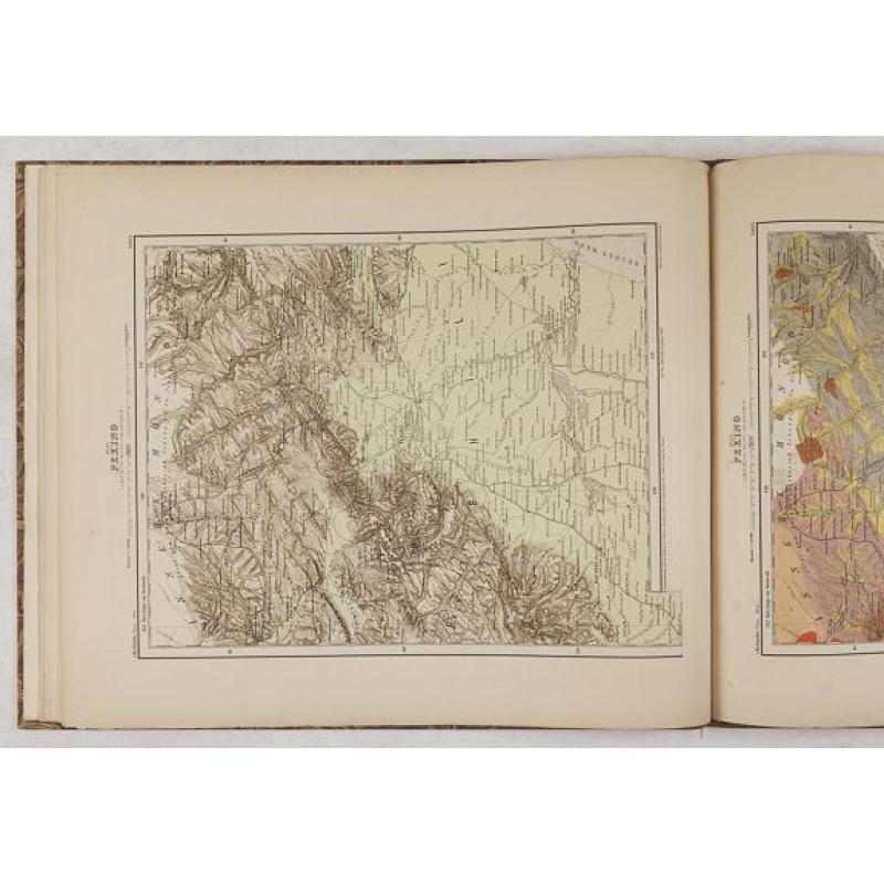
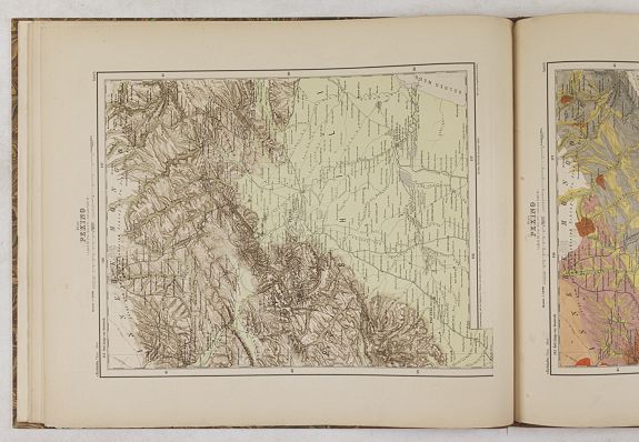
(Ortographische und geologische Karten. Erste Abtheilung: Das nördliche China.) |
||||||||||||||||||||
|
||||||||||||||||||||
|
|
||||||||||||||||||||
|
Selling price: $2500
Sold Missed this item! Be the first to get notified about our newly added listings. Add your name to our mailing list. |
Virtual Collection - Save and collect your favorite items in one place.
Unless logged in, the item is only saved for that session. If you want to save the items permanently, please Login first Learn more [+] |
|||||||||||||||||||
Description
Ferdinand Freiherr von Richthofen (5 May 1833 – 6 October 1905) who was a German traveler, geographer, and scientist, was born in Karlsruhe, Prussian Silesia, and was educated in Breslau and Berlin. He traveled or studied in the Alps of Tyrol and the Carpathians in Transylvania. In 1860, he joined the Eulenburg Expedition, a Prussian expedition which visited Ceylon, Japan, Taiwan, Celebes, Java, Siam, Burma between 1860 and 1862.
China was at the time inaccessible owing to the Taiping rebellion, but Richthofen was impressed with the desirability of exploring it.
From 1862 to 1868, he worked as a geologist in the United States, discovering goldfields in California.
Between 1868 and 1872 he traveled through 11 of the 18 provinces of China doing geographic and geologic research. His trip was partly funded by the Shanghai Chamber of Commerce and he compiled a series of reports for them on his travels which were printed in English in 1900 under the title Baron Von Richthofen’s Letters.
On one of his journeys during this period he traveled the entire Road to Shu via the Linking Cloud Road in the North and the Golden Oxen Road in the south. His record of this trip in English is contained in the compilation of his letters written for the Chamber of Commerce which was published in 1900.
After four years of travel and field work in China, he returned to Germany to teach and write his monumental geological treatise entitled "China, Ergebnisse eigner Reisen und darauf gegründeter Studien". In total the work consits of 5 text volumes and 2 atlases, published 1877-1885, three posthumous volumes appeared in 1911 and 1912 (the second atlas " Zweite Abtheilung : "das Südliche China" prepared by dr. Max Groll).
In this standard work, the author deals not only with geology but with every subject necessary to a general geographical treatise. Notably he paid close attention to the economic resources of the country he traversed.
It is considered to be the first scientific atlas about China, and for a long period the only work of reference avaliable.
"Der Atlas, ein exemplarisches Pionierwerk, leitete die orographische und geologische Kartendarstellung Chinas ein. Die einzelnen Blätter beruhen auf R. s eigenen Aufnahmen. In der Erforschung Chinas hat R. Unvergleichliches geschaffen” --- (Henze)
He also wrote a valuable series of letters to the Shanghai Chamber of Commerce, and first drew attention to the importance of the coalfields of Shantung, and of Kiaochow as a port.
In China he located the dried-up lake bed of Lopnur. He made also trips to Japan, Burma, and Java.
He was appointed professor of geology at the University of Bonn beginning in 1875, but being fully occupied with his work in China he did not take up professorial duties until 1879. He became professor of geography at the University of Leipzig in 1883, and professor of geography at the Friedrich Wilhelm University of Berlin in 1886. He occupied the latter position until his death.
His lectures attracted numerous students who subsequently became eminent in geographical work, and in order to keep in touch with them he established his weekly geographical “colloquium.”
Among his most famous students was Sven Hedin, the Swedish explorer/traveler in Mongolia and Tibet.
Von Richthofen was the first who coined the term “Silk Road” for China’s foreign trade routes and the term “Red Basin” for the hilly, red sandstone plain occupying much of eastern Sichuan. He was also the first to deduce that the origin of the loess soil deposits of north China was a fine Aeolian dust originally blown into China from the desert regions to the west and gradually deposited over many centuries.
He served as president of the German Geographical Society for many years and founded the Berlin Hydrographical Institute. He standardized the practices of chorography and chorology.
He died in 1905 in Berlin.
Provenance : The library of Swedish Sinologist, rare book collector and bookseller Björn Löwendahl (1941-2013).
Reference: Cordier I, 97. Henze IV, 613. Phillips 3191 (the first vol.). See also Löwendahl: China illustrata nova, 1489. Only the first atlas volume.
FAQ - Guarantee - Shipping
Buying in the BuyNow Gallery
This item is available for immediate purchase when a "Add to Cart" or "Inquire Now" button is shown.
Items are sold in the EU margin scheme
Payments are accepted in Euros or US Dollars.
Authenticity Guarantee
 We provide professional descriptions, condition report (based on 45 years experience in the map business)
Paulus Swaen warrants the authenticity of our items and a certificate of authenticity is provided for each acquired lot.
Condition and Coloring
We indicate the condition of each item and use our unnique HiBCoR grading system in which four key items determine a map's value: Historical Importance, Beauty, Condition/Coloring and Rarity.
Color Key
We offer many maps in their original black and white condition. We do not systematically color-up maps to make them more sellable to the general public or buyer.
Copper engraved or wood block maps are always hand colored. Maps were initially colored for aesthetic reasons and to improve readability. Nowadays, it is becoming a challenge to find maps in their original colors and are therefor more valuable.
We use the following color keys in our catalog:
Original colors; mean that the colors have been applied around the time the map was issued.
Original o/l colors; means the map has only the borders colored at the time of publication.
Colored; If the colors are applied recently or at the end of the 20th century.
Read more about coloring of maps [+]
Shipping fee
A flat shipping fee of $ 30 is added to each shipment by DHL within Europe and North America. This covers : International Priority shipping, Packing and Insurance (up to the invoice amount).
Shipments to Asia are $ 40 and rest of the world $50
We charge only one shipping fee when you have been successful on multiple items or when you want to combine gallery and auction purchases.
Read more about invoicing and shipping
FAQ
Please have a look for more information about buying in the BuyNow gallery
Many answers are likely to find in the general help section.
Virtual Collection
![]()
With Virtual Collection you can collect all your favorite items in one place. It is free, and anyone can create his or her Virtual map collection.
Unless you are logged in, the item is only saved for this session. You have to be registed and logged-in if you want to save this item permanently to your Virtual Collection.
Read More[+]
Register here, it is free and you do not need a credit card.
Add this item to
Virtual Collection
or click the following link to see my Virtual Collection.
| High-Resolution Digital Image Download | |
|
Paulus Swaen maintains an archive of most of our high-resolution rare maps, prints, posters and medieval manuscript scans. We make them freely available for download and study. Read more about free image download |
Click this image for a free HR-image download. |
In accordance with the EU Consumer Rights Directive and habitually reside in the European Union you have the right to cancel the contract for the purchase of a lot, without giving any reason.
The cancellation period will expire 14 calendar days from the day after the date on which you or a third party (other than the carrier and indicated by you) acquires, physical possession of the lot. To exercise the right to cancel you must inform Paulus Swaen Europe bv, which is offering to sell the lot either as an agent for the seller or as the owner of the lot, of your decision to cancel this contract by a clear statement (e.g. a letter sent by post, or e-mail (amsterdam@swaen.com).
To meet the cancellation deadline, it is sufficient for you to send your communication concerning your exercise of the right to cancel before the cancellation period has expired.