Subscribe to be notified if similar examples become available.
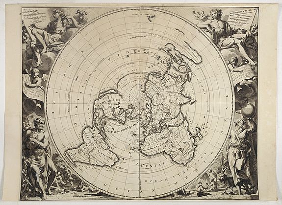
Planisphere Terrestre, Suivant les nouvelles Observations des Astronomes. |
||||||||||||||||||||
|
||||||||||||||||||||
|
|
||||||||||||||||||||
|
Selling price: $5500
Sold in 2018 Missed this item! Be the first to get notified about our newly added listings. Feel free to contact us if you have a question about this item. Add your name to our mailing list. |
Virtual Collection - Save and collect your favorite items in one place.
Unless logged in, the item is only saved for that session. If you want to save the items permanently, please Login first Learn more [+] |
|||||||||||||||||||
Description
As the information was collected and sent to Paris, it was transferred to a gigantic planisphere.
Cassini was a highly trained and disciplined scientist, a skilled astronomer, and a geodesist.
This was the first map to set standard longitudes for known places based on scientific calculations.
This spectacular adaptation of the map by Van der Aa is perhaps the most elegantly engraved of California as an island map.
Etched by Gilliam van der Gouwen (ca. 1640, Antwerp? - in or after 1720) after J. Goeree.
Technological advancements in the seventeenth century brought dramatic change to the history of European map-making. Diverging from the traditional Ptolemic world maps, cartographers experimented with different ways to illustrate the world's surface, such as the "Polar Projection," in which one of the poles is shown at or near the center of the map. The earth is illustrated as viewed from a long distance.
Van der Aa's striking engraving is based on an earlier polar projection, executed by Frenchman Jean Dominique Cassini. Cassini's map, produced in 1682, measured 8 meters long and lay on the French Academy of Sciences floor, of which Cassini was appointed director in 1671. Like its predecessor, the van der Aa map contained the most up-to-date cartographical information available in its day. The internal detail of this map-the marking of the astrological stations with small stars and the intricate notation of the geographical characteristics of the continents-is an indication of the extensive development of navigational techniques made in Europe in the seventeenth century.
While retaining the precision and beauty of the original Cassini map, van der Aa elaborates on the design by adding masterfully engraved classical figures in each of the map's four corners. The tradition of decorative border engravings came into being in the later seventeenth century. Such illustrations added information to the basic cartographic content of each map and often served to educate the viewer about the continents' inhabitants, culture, and environment. Van der Aa was a venerated publisher and cartographer in the late seventeenth and early eighteenth centuries. He had his own publishing house in Leiden, Germany, where he produced numerous Atlases, including "La Galerie Agrédable du Monde" (1729) and "Nouveau Theatre du Monde" (1713), in which this map appeared.
Reference: Karpinski, XXXVII, p.117: Bagrow, History of Cartography.
FAQ - Guarantee - Shipping
Buying in the BuyNow Gallery
This item is available for immediate purchase when a "Add to Cart" or "Inquire Now" button is shown.
Items are sold in the EU margin scheme
Payments are accepted in Euros or US Dollars.
Authenticity Guarantee
 We provide professional descriptions, condition report (based on 45 years experience in the map business)
Paulus Swaen warrants the authenticity of our items and a certificate of authenticity is provided for each acquired lot.
Condition and Coloring
We indicate the condition of each item and use our unnique HiBCoR grading system in which four key items determine a map's value: Historical Importance, Beauty, Condition/Coloring and Rarity.
Color Key
We offer many maps in their original black and white condition. We do not systematically color-up maps to make them more sellable to the general public or buyer.
Copper engraved or wood block maps are always hand colored. Maps were initially colored for aesthetic reasons and to improve readability. Nowadays, it is becoming a challenge to find maps in their original colors and are therefor more valuable.
We use the following color keys in our catalog:
Original colors; mean that the colors have been applied around the time the map was issued.
Original o/l colors; means the map has only the borders colored at the time of publication.
Colored; If the colors are applied recently or at the end of the 20th century.
Read more about coloring of maps [+]
Shipping fee
A flat shipping fee of $ 30 is added to each shipment by DHL within Europe and North America. This covers : International Priority shipping, Packing and Insurance (up to the invoice amount).
Shipments to Asia are $ 40 and rest of the world $50
We charge only one shipping fee when you have been successful on multiple items or when you want to combine gallery and auction purchases.
Read more about invoicing and shipping
FAQ
Please have a look for more information about buying in the BuyNow gallery
Many answers are likely to find in the general help section.
Virtual Collection
![]()
With Virtual Collection you can collect all your favorite items in one place. It is free, and anyone can create his or her Virtual map collection.
Unless you are logged in, the item is only saved for this session. You have to be registed and logged-in if you want to save this item permanently to your Virtual Collection.
Read More[+]
Register here, it is free and you do not need a credit card.
Add this item to
Virtual Collection
or click the following link to see my Virtual Collection.
| High-Resolution Digital Image Download | |
|
Paulus Swaen maintains an archive of most of our high-resolution rare maps, prints, posters and medieval manuscript scans. We make them freely available for download and study. Read more about free image download |
Click this image for a free HR-image download. |
In accordance with the EU Consumer Rights Directive and habitually reside in the European Union you have the right to cancel the contract for the purchase of a lot, without giving any reason.
The cancellation period will expire 14 calendar days from the day after the date on which you or a third party (other than the carrier and indicated by you) acquires, physical possession of the lot. To exercise the right to cancel you must inform Paulus Swaen Europe bv, which is offering to sell the lot either as an agent for the seller or as the owner of the lot, of your decision to cancel this contract by a clear statement (e.g. a letter sent by post, or e-mail (amsterdam@swaen.com).
To meet the cancellation deadline, it is sufficient for you to send your communication concerning your exercise of the right to cancel before the cancellation period has expired.