(Sheet X with Puk Bay from) General Tableau zur Karte von Alt Ost und West Preussen nebst dem aufgenommenen Trigonometrischen Netz. . . |
||||||||||||||||||||
|
||||||||||||||||||||
|
|
||||||||||||||||||||
$100 / ≈ €88This item is available for immediate sale! Questions before Buying ?
We are happy to answer your questions. Feel free to contact us if you have a question about this item.
Or do you like to be notified about newly added items? Add your name to our mailing list.
100.00
|
Virtual Collection - Save and collect your favorite items in one place.
Unless logged in, the item is only saved for that session. If you want to save the items permanently, please Login first Learn more [+] |
|||||||||||||||||||
Description
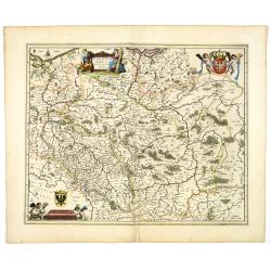
The rare first edition of this important 25-sheet map prepared by Friedrich Leopold von Schrötter. This map sheet was engraved by Carl Jäck.
In 1796 under the leadership of Friedrich Leopold von Schröter (1743-1815) a mapping of East Prussia in scale 1:50000 was started. The work completed in 1802, set of maps "Karte von den Provinzen Litthauen, Ost und West Preussen u.d. Netz Distrikte auf befehl Ihrer Majestäten des Königs Friedrich Wilhelm II und Friedrich Wilhelm III auf Antrag des Staats Ministers und Departements Chefs Freiherrn von Schrötter in den Jahren 1796 bis 1802 vermessen und topographisch aufgenommen von Friedrich Bernhard Engelhardt Königlichem Kriegs und Domainen Rathe und Ban Director in Neu-Ost-Preussen" was created.
Based on this mapping in 1802 a set of maps Karte von Alt-Preussen enthaltend Ost=Preusen nebst Preussisch Lithauen. . .was issued.
The title of the map was however quickly changed to Karte von Ost-Preussen nebst Preussisch Litthauen und West - Preussen nebst dem Netzdistrict and the title of the King was also changed in the second state.
Several engravers worked on the different sheets: Carl Jäck (I-III, V-VII, X-XII, XV, XVI, XVIIII, XXII, 1802-1806), Carl Mare (XIII-XV, XVII, XIX, XXII, XXV, 1806-1810), Heinrich Kliewer (IV, XXIV, 1803), Franz (XX, XXI), Paulus Schmidt (VIII, XXIII, town plans)
The map on its turn was a reduction of 145-sheets manuscript map in scale 1:50 000 made by F. L. Schrötter.
Reference: Jäger, Prussia-Karten, 275.
FAQ - Guarantee - Shipping
Buying in the BuyNow Gallery
This item is available for immediate purchase when a "Add to Cart" or "Inquire Now" button is shown.
Items are sold in the EU margin scheme
Payments are accepted in Euros or US Dollars.
Authenticity Guarantee
 We provide professional descriptions, condition report (based on 45 years experience in the map business)
Paulus Swaen warrants the authenticity of our items and a certificate of authenticity is provided for each acquired lot.
Condition and Coloring
We indicate the condition of each item and use our unnique HiBCoR grading system in which four key items determine a map's value: Historical Importance, Beauty, Condition/Coloring and Rarity.
Color Key
We offer many maps in their original black and white condition. We do not systematically color-up maps to make them more sellable to the general public or buyer.
Copper engraved or wood block maps are always hand colored. Maps were initially colored for aesthetic reasons and to improve readability. Nowadays, it is becoming a challenge to find maps in their original colors and are therefor more valuable.
We use the following color keys in our catalog:
Original colors; mean that the colors have been applied around the time the map was issued.
Original o/l colors; means the map has only the borders colored at the time of publication.
Colored; If the colors are applied recently or at the end of the 20th century.
Read more about coloring of maps [+]
Shipping fee
A flat shipping fee of $ 30 is added to each shipment by DHL within Europe and North America. This covers : International Priority shipping, Packing and Insurance (up to the invoice amount).
Shipments to Asia are $ 40 and rest of the world $50
We charge only one shipping fee when you have been successful on multiple items or when you want to combine gallery and auction purchases.
Read more about invoicing and shipping
FAQ
Please have a look for more information about buying in the BuyNow gallery
Many answers are likely to find in the general help section.
Virtual Collection
![]()
With Virtual Collection you can collect all your favorite items in one place. It is free, and anyone can create his or her Virtual map collection.
Unless you are logged in, the item is only saved for this session. You have to be registed and logged-in if you want to save this item permanently to your Virtual Collection.
Read More[+]
Register here, it is free and you do not need a credit card.
Add this item to
Virtual Collection
or click the following link to see my Virtual Collection.
| High-Resolution Digital Image Download | |
|
Paulus Swaen maintains an archive of most of our high-resolution rare maps, prints, posters and medieval manuscript scans. We make them freely available for download and study. Read more about free image download |
Click this image for a free HR-image download. |

In accordance with the EU Consumer Rights Directive and habitually reside in the European Union you have the right to cancel the contract for the purchase of a lot, without giving any reason.
The cancellation period will expire 14 calendar days from the day after the date on which you or a third party (other than the carrier and indicated by you) acquires, physical possession of the lot. To exercise the right to cancel you must inform Paulus Swaen Europe bv, which is offering to sell the lot either as an agent for the seller or as the owner of the lot, of your decision to cancel this contract by a clear statement (e.g. a letter sent by post, or e-mail (amsterdam@swaen.com).
To meet the cancellation deadline, it is sufficient for you to send your communication concerning your exercise of the right to cancel before the cancellation period has expired.