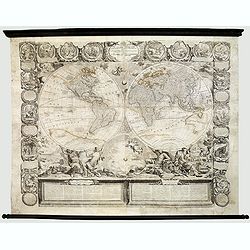
Le globe terrestre representé en deux plans-hemispheres, Dressé sur la Projection de Mr. De la Hyre... |
||||||||||||||||||||
|
||||||||||||||||||||
|
|
||||||||||||||||||||
$17500 / ≈ €15398This item is available for immediate sale! Questions before Buying ?
We are happy to answer your questions.
17500.00
|
Virtual Collection - Save and collect your favorite items in one place.
Unless logged in, the item is only saved for that session. If you want to save the items permanently, please Login first Learn more [+]
Watchers:
16
|
|||||||||||||||||||
Description
This superbly engraved wall map in twin hemispheres and their surround are engraved on four sheets with further strips comprising a broad pictorial border on top and left and right sides. The map has been laid down on canvas and has wooden rollers.
In the bottom, architectural columns of text. The elaborate decorative border contains sixteen medallion vignettes, each depicting an event in biblical history according to contemporary terms.
This fine large-scale world map results from a partnership between Nolin and the celebrated painter Bocquet, who carried out Nolin’s extraordinary conception with stunning results. The two hemispheres are supported by large mythical figures and surrounded by images of the creation of heaven and earth.
This is the 1775 re-issue by Crépy and has a redrawn with "Mer de l'ouest" reduced in size.
The original 1700 edition of Nolin’s map was the first to delineate the famous Mer de l’Ouest in North America, fueling the prominent fantasy of a Northwest Passage. Although the fictitious sea has been reduced in size in this later edition (and would eventually disappear from the map completely), the enthusiasm for a Northwest Passage remains, this time portrayed in the Detroit d’Anian which attempts to link Hudson Bay to the Pacific Ocean.
Nolin’s delineation of Australia contains an entirely new eastern coastline, “linking Papua-New Guinea and Tasmania in one sweep. This feature is to be found on many later 18th-century maps and was not to be corrected until the discoveries of Captain Cook in the 1770's.
Separately published. Rare.
Interesting for its dual naming of "Mer du Corée" and “Mer du Japon” for the Sea in between Japan and Korea.
Maps of this style were intended for the offices and homes of important merchants, officials and dignitaries. Owing to the vulnerability of such wall decoration very few such maps now come onto the market. This map, although with evidence of paper cracking, some parts with paper re-inforcement, is nevertheless a striking example of the most impressive combination of cartography and art.
Reference: Shirley, The Mapping of the World, 605.
FAQ - Guarantee - Shipping
Buying in the BuyNow Gallery
This item is available for immediate purchase when a "Add to Cart" or "Inquire Now" button is shown.
Items are sold in the EU margin scheme
Payments are accepted in Euros or US Dollars.
Authenticity Guarantee
 We provide professional descriptions, condition report (based on 45 years experience in the map business)
Paulus Swaen warrants the authenticity of our items and a certificate of authenticity is provided for each acquired lot.
Condition and Coloring
We indicate the condition of each item and use our unnique HiBCoR grading system in which four key items determine a map's value: Historical Importance, Beauty, Condition/Coloring and Rarity.
Color Key
We offer many maps in their original black and white condition. We do not systematically color-up maps to make them more sellable to the general public or buyer.
Copper engraved or wood block maps are always hand colored. Maps were initially colored for aesthetic reasons and to improve readability. Nowadays, it is becoming a challenge to find maps in their original colors and are therefor more valuable.
We use the following color keys in our catalog:
Original colors; mean that the colors have been applied around the time the map was issued.
Original o/l colors; means the map has only the borders colored at the time of publication.
Colored; If the colors are applied recently or at the end of the 20th century.
Read more about coloring of maps [+]
Shipping fee
A flat shipping fee of $ 30 is added to each shipment by DHL within Europe and North America. This covers : International Priority shipping, Packing and Insurance (up to the invoice amount).
Shipments to Asia are $ 40 and rest of the world $50
We charge only one shipping fee when you have been successful on multiple items or when you want to combine gallery and auction purchases.
Read more about invoicing and shipping
FAQ
Please have a look for more information about buying in the BuyNow gallery
Many answers are likely to find in the general help section.
Virtual Collection
![]()
With Virtual Collection you can collect all your favorite items in one place. It is free, and anyone can create his or her Virtual map collection.
Unless you are logged in, the item is only saved for this session. You have to be registed and logged-in if you want to save this item permanently to your Virtual Collection.
Read More[+]
Register here, it is free and you do not need a credit card.
Add this item to
Virtual Collection
or click the following link to see my Virtual Collection.
| High-Resolution Digital Image Download | |
|
Paulus Swaen maintains an archive of most of our high-resolution rare maps, prints, posters and medieval manuscript scans. We make them freely available for download and study. Read more about free image download |
Click this image for a free HR-image download. |

In accordance with the EU Consumer Rights Directive and habitually reside in the European Union you have the right to cancel the contract for the purchase of a lot, without giving any reason.
The cancellation period will expire 14 calendar days from the day after the date on which you or a third party (other than the carrier and indicated by you) acquires, physical possession of the lot. To exercise the right to cancel you must inform Paulus Swaen Europe bv, which is offering to sell the lot either as an agent for the seller or as the owner of the lot, of your decision to cancel this contract by a clear statement (e.g. a letter sent by post, or e-mail (amsterdam@swaen.com).
To meet the cancellation deadline, it is sufficient for you to send your communication concerning your exercise of the right to cancel before the cancellation period has expired.