Subscribe to be notified if similar examples become available.
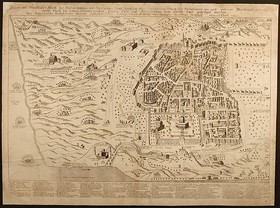
Wahrer und Grundlicher Abriss der Welt-beruhmten und Hochheiligen Stadt Jerusalem aller angrenzenden Oertern und Heiligt³mern wie auch anderer Merckwurdigkeiten welche durch das Leben, Wunderzeichen, Leiden, Todt, und Auferstehung Jesu Christi seynd gehei |
||||||||||||||||||||
|
||||||||||||||||||||
|
|
||||||||||||||||||||
|
Selling price: $3700
Sold in 2009 Missed this item! Be the first to get notified about our newly added listings. Feel free to contact us if you have a question about this item. Add your name to our mailing list. |
Virtual Collection - Save and collect your favorite items in one place.
Unless logged in, the item is only saved for that session. If you want to save the items permanently, please Login first Learn more [+] |
|||||||||||||||||||
Description
Only a handful copies are known : one in the Eran Laor Collection at the Jewish National and University Library, another one in the Hauslab-Liechtenstein collection in the Library of Congress, Washington, D.C. and the third one was sold at Sotheby's, London in 1999.
This large map was printed from an engraved copperplate and is a detailed map of Jerusalem and environment showing the central part of the Holy Land from Death Sea in the East to the coastal line in West. North-South direction showing the outskirts of Jerusalem up to Hebron. The date of the map is encrypted in a chronogram in the third line of the title:
Ihro KaIserLIChen KonIgLIChen MaIestat ELIsabetha ChrIstIna V hoChst VnterthanIgster obserVanz fLeIssIgst abgezeIChnet.
The capitals representing Roman numerals and adding these together is equal 1728: 13 x I (1) = 13, 3 x V (5) = 15, 4 x L (50) = 200, 5 x C (100) = 500, 1 x M (1000) = 1000
This date corresponds with the life of Elisabetha Christina (1691-1750), born as Elisabeth of Braunschweig (Brunswick) and married to Charles VI in 1708, became Queen of Bohemia and Hungary. Her child became the famous Maria Theresia (McGuigan, Habsburgs, New York, 1966).
This map is "unusual in its rich details, its reliability, the many illustrations of sites and figures, and the large area it encompasses" (R. Rubin, Maps of Jerusalem, pp.152-153). The representation of Jerusalem is authentic and many buildings can be identified. Many site on the map refer the Christian background but also Arab horseman, Greek monks and camel caravans are shown. A lot of well engraved details are captured. For example Judas Iscariot is hanging from a tree, the graves of the Maccabees, the four cities of Sodom, Gomorrah, Adamah and Zeboim. "De Pierre paid special attention to Christian monasteries in Jerusalem as well as in the Judean Desert. The reason may be that he copied a Greek Orthodox map included in the book by the Greek Orthodox Patriarch Chrysanthos printed in the same year" (R. Rubin). Below an index with 71 numbers is listed, referring to buildings and sited within the the city itself. Around 100 additional descriptions outside the city walls are printed within the map close to each site location.
The identity of the author itself in unknown. The only indication is "De Pierre Eques S.S. Sepulchri" which appears in the lower left edge in the map. "This title was bestowed by the Franciscan order in Jerusalem upon European Catholic noblemen who had completed a pilgrimage" (R. Rubin).
References: E. Laor: "Maps of the Holy Land", Amsterdam, 1986, pp. 145-146 / R. Rubin: "The de Pierre Map of Jerusalem, 1728", 16th International Conference on the History of Cartography, Vienna, September 1996 / R. Rubin: "The De-Pierre map of Jerusalem 1728", Studies in Geography and History in Honor of Yehoshua Ben Arieh, Jerusalem 1999, pp. 1-28 (Hebrew) / R. Rubin: "A Chonogram-dated Map of Jerusalem", The Map Collector 55, pp. 30-31.
Reference: E. Laor: \\\
FAQ - Guarantee - Shipping
Buying in the BuyNow Gallery
This item is available for immediate purchase when a "Add to Cart" or "Inquire Now" button is shown.
Items are sold in the EU margin scheme
Payments are accepted in Euros or US Dollars.
Authenticity Guarantee
 We provide professional descriptions, condition report (based on 45 years experience in the map business)
Paulus Swaen warrants the authenticity of our items and a certificate of authenticity is provided for each acquired lot.
Condition and Coloring
We indicate the condition of each item and use our unnique HiBCoR grading system in which four key items determine a map's value: Historical Importance, Beauty, Condition/Coloring and Rarity.
Color Key
We offer many maps in their original black and white condition. We do not systematically color-up maps to make them more sellable to the general public or buyer.
Copper engraved or wood block maps are always hand colored. Maps were initially colored for aesthetic reasons and to improve readability. Nowadays, it is becoming a challenge to find maps in their original colors and are therefor more valuable.
We use the following color keys in our catalog:
Original colors; mean that the colors have been applied around the time the map was issued.
Original o/l colors; means the map has only the borders colored at the time of publication.
Colored; If the colors are applied recently or at the end of the 20th century.
Read more about coloring of maps [+]
Shipping fee
A flat shipping fee of $ 30 is added to each shipment by DHL within Europe and North America. This covers : International Priority shipping, Packing and Insurance (up to the invoice amount).
Shipments to Asia are $ 40 and rest of the world $50
We charge only one shipping fee when you have been successful on multiple items or when you want to combine gallery and auction purchases.
Read more about invoicing and shipping
FAQ
Please have a look for more information about buying in the BuyNow gallery
Many answers are likely to find in the general help section.
Virtual Collection
![]()
With Virtual Collection you can collect all your favorite items in one place. It is free, and anyone can create his or her Virtual map collection.
Unless you are logged in, the item is only saved for this session. You have to be registed and logged-in if you want to save this item permanently to your Virtual Collection.
Read More[+]
Register here, it is free and you do not need a credit card.
Add this item to
Virtual Collection
or click the following link to see my Virtual Collection.
| High-Resolution Digital Image Download | |
|
Paulus Swaen maintains an archive of most of our high-resolution rare maps, prints, posters and medieval manuscript scans. We make them freely available for download and study. Read more about free image download |
Click this image for a free HR-image download. |
In accordance with the EU Consumer Rights Directive and habitually reside in the European Union you have the right to cancel the contract for the purchase of a lot, without giving any reason.
The cancellation period will expire 14 calendar days from the day after the date on which you or a third party (other than the carrier and indicated by you) acquires, physical possession of the lot. To exercise the right to cancel you must inform Paulus Swaen Europe bv, which is offering to sell the lot either as an agent for the seller or as the owner of the lot, of your decision to cancel this contract by a clear statement (e.g. a letter sent by post, or e-mail (amsterdam@swaen.com).
To meet the cancellation deadline, it is sufficient for you to send your communication concerning your exercise of the right to cancel before the cancellation period has expired.