Subscribe to be notified if similar examples become available.
United States of America the British Provinces, Mexico... |
||||||||||||||||||||
|
||||||||||||||||||||
|
|
||||||||||||||||||||
|
Selling price: $3600
Sold in 2019 Missed this item! Be the first to get notified about our newly added listings. Add your name to our mailing list. |
Virtual Collection - Save and collect your favorite items in one place.
Unless logged in, the item is only saved for that session. If you want to save the items permanently, please Login first Learn more [+] |
|||||||||||||||||||
Description
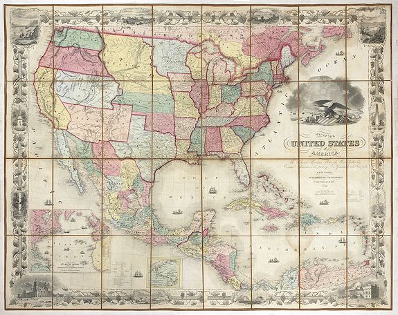
The map's coverage extends from Canada to Colombia, inclusive of all of the United States, Mexico, Central America, and the West Indies.
This edition includes 2 short-lived western territorial anomalies, the "Uninhabited" lands between New Mexico and Chihuahua and the block of land between Kansas, Indian Territory and Texas, which would later be split between Kansas. Including the "Public Land Strip" or No mans Land in Indian Territory. The Chickasaw Nation established its Constitution Family and community have always played a major role in the survival and prosperity of our Chickasaw people. This sense of belonging to a greater whole translated itself into a stronger national pride. The Chickasaw Nation established its Constitution of 1856 during huge gatherings at Good Spring (now Tishomingo, Oklahoma), and we established our own territory in present-day, south-central Oklahoma.
Despite numerous challenges and occasional setbacks, our Chickasaw people continued to create new ways to protect and manage the new lands and water and to protect wildlife and natural resources. Shortly after the forced removal from our Southeastern Homeland, homes were rebuilt, farms recreated, communities and businesses reestablished, churches and even commissioned schools re-erected. Infrastructure sprang up out of the land, connecting towns and creating new roads. Industry and commerce became a way of life. A governor was chosen, rather than a chief, to serve as the “supreme executive power.
Inset maps: - "The Isthmus or Panama showing the routes of travel between Chagres & Panama". - "A map of the Atlantic Ocean showing the American & European ports and the routes of the Atlantic steamers".The elaborate grapevine borders, including 12 vignettes of various places of interest, including : Willammette Falls, Oregon -- Astoria, Oregon -- Saratoga Lake, New York -- Valley of the Connecticut from Mt. Holyoke -- Bunker Hill Monument Boston, Mass. -- Washington Monument New York -- Capitol, Washington City -- Entrance of a port -- Mexicans catching wild cattle -- -- Cathedral, City of Mexico -- Pulaski Monument Savannah, Ga. -- Pulaski Monument Savannah, Ga. --- Battle Monument Baltimore, Md.
In the 1850s, J.H. Colton published several separately issued maps of the United States, including his "pocket map edition," the "wall map" edition and this very rare medium sized wall map version, which was available either in 2-sheets or dissected and laid on linen (as offered here). Colton's maps offered one of the most up to date and comprehensive views of the United States and were revised at least annually, often more than once a year, as information flowed in from the early Western Surveys sponsored by the United States Government and as new territories were created and regions opened up to settlement.
The present map shows the region west of the Mississippi River immediately before the Gadsden Purchase, including the newly formed Washington Territory (1853), Kansas Territory (1854), and Minnesota Territory (1849) and revised configurations for Nebraska Territory and Oregon Territory (which did not gain statehood until 1859). The map is richly updated with the best available information from the west. These include the New York - Boston - Halifax - Liverpool route. Various other routes run from the Havana to Madeira and spider-web throughout the West Indies. No fewer than 15 decorative ships, including both tall ships and steam vessels, decorate the seas. The dramatic cartouche image includes a large Bald Eagle sitting astride a stars and stripes armorial shield and various trade goods.
A bustling port scene appears in the background. Colton first issued this map in 1849. Another edition followed later in 1849 in anticipation of the Compromise of 1850 and including updates relating to the explorations of Fremont and the discovery of Gold at Sutter's Mill. Subsequent editions were prepared annually until about 1859. While the early editions of the map appear on the market periodically, this mid-1850s example is very rare.
FAQ - Guarantee - Shipping
Buying in the BuyNow Gallery
This item is available for immediate purchase when a "Add to Cart" or "Inquire Now" button is shown.
Items are sold in the EU margin scheme
Payments are accepted in Euros or US Dollars.
Authenticity Guarantee
 We provide professional descriptions, condition report (based on 45 years experience in the map business)
Paulus Swaen warrants the authenticity of our items and a certificate of authenticity is provided for each acquired lot.
Condition and Coloring
We indicate the condition of each item and use our unnique HiBCoR grading system in which four key items determine a map's value: Historical Importance, Beauty, Condition/Coloring and Rarity.
Color Key
We offer many maps in their original black and white condition. We do not systematically color-up maps to make them more sellable to the general public or buyer.
Copper engraved or wood block maps are always hand colored. Maps were initially colored for aesthetic reasons and to improve readability. Nowadays, it is becoming a challenge to find maps in their original colors and are therefor more valuable.
We use the following color keys in our catalog:
Original colors; mean that the colors have been applied around the time the map was issued.
Original o/l colors; means the map has only the borders colored at the time of publication.
Colored; If the colors are applied recently or at the end of the 20th century.
Read more about coloring of maps [+]
Shipping fee
A flat shipping fee of $ 30 is added to each shipment by DHL within Europe and North America. This covers : International Priority shipping, Packing and Insurance (up to the invoice amount).
Shipments to Asia are $ 40 and rest of the world $50
We charge only one shipping fee when you have been successful on multiple items or when you want to combine gallery and auction purchases.
Read more about invoicing and shipping
FAQ
Please have a look for more information about buying in the BuyNow gallery
Many answers are likely to find in the general help section.
Virtual Collection
![]()
With Virtual Collection you can collect all your favorite items in one place. It is free, and anyone can create his or her Virtual map collection.
Unless you are logged in, the item is only saved for this session. You have to be registed and logged-in if you want to save this item permanently to your Virtual Collection.
Read More[+]
Register here, it is free and you do not need a credit card.
Add this item to
Virtual Collection
or click the following link to see my Virtual Collection.
| High-Resolution Digital Image Download | |
|
Paulus Swaen maintains an archive of most of our high-resolution rare maps, prints, posters and medieval manuscript scans. We make them freely available for download and study. Read more about free image download |
Click this image for a free HR-image download. |
In accordance with the EU Consumer Rights Directive and habitually reside in the European Union you have the right to cancel the contract for the purchase of a lot, without giving any reason.
The cancellation period will expire 14 calendar days from the day after the date on which you or a third party (other than the carrier and indicated by you) acquires, physical possession of the lot. To exercise the right to cancel you must inform Paulus Swaen Europe bv, which is offering to sell the lot either as an agent for the seller or as the owner of the lot, of your decision to cancel this contract by a clear statement (e.g. a letter sent by post, or e-mail (amsterdam@swaen.com).
To meet the cancellation deadline, it is sufficient for you to send your communication concerning your exercise of the right to cancel before the cancellation period has expired.