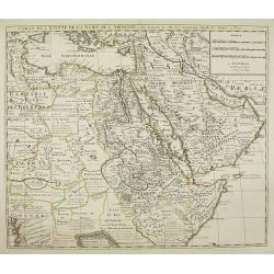
[Title page to] Atlas mayor, o geographia Blaviana : Que contiene las cartas, y descripciones de Partes Orientales de Europa. |
||||||||||||||||||||
|
||||||||||||||||||||
|
|
||||||||||||||||||||
$700 / ≈ €617This item is available for immediate sale! Questions before Buying ?
We are happy to answer your questions. Feel free to contact us if you have a question about this item.
Or do you like to be notified about newly added items? Add your name to our mailing list.
700.00
|
Virtual Collection - Save and collect your favorite items in one place.
Unless logged in, the item is only saved for that session. If you want to save the items permanently, please Login first Learn more [+] |
|||||||||||||||||||
Description
Learn more about maps in exceptional colors [+]
The atlas Major was printed only in small numbers, the Spanish text edition is scarce. The Spanish edition was never completed. When fire destroyed the Blaeu printing house at the Gravenstraat in Amsterdam in 1672, the final volume was in the press and consequently lost.
The Atlas Maior is the epitome of decades of achievement by the Blaeu family. Published in five languages (Latin, Dutch, French, German and Spanish) from 1662, it grew to eleven or twelve volumes in its most comprehensive editions, and was as Koeman observes a "costly atlas . . . Exclusively designed for those members of the patriciate who could command both the material and intellectual resources that were needed to buy and appreciate it". Joan's father, Willem Blaeu, commenced publication of his new world atlas, the Theatrum Orbis Terrarum, also referred to as the Atlas Novus, initially in two volumes, published in four languages. After succeeding his father, Joan Blaeu progressively expanded the Atlas Novus to six volumes by 1655, and this formed the first half the Atlas Maior.
The rare Spanish edition of the Atlas Maior occupies an extraordinary place within the Blaeu epic. In contrast to the editions in other languages, its volumes were printed serially over fifteen years, printed in more limited quantity, bore different titles, and were not numbered. The genesis of this project came with the decision to produce the Spanish Atlas Nuevo, with the volume relating to Scotland first published in 1657, and that on China the following year.
In 1659 the volumes relating to Northern Europe, Eastern Europe and England were produced, along with second editions of the two volumes already published. Even before Joan Blaeu had made preparations to publish the Atlas Maior in other languages, he decided to turn the extant volumes of the Atlas Nuevo into the first five volumes of the Atlas Mayor. The long process of production meant that there were variations in title and imprint, as well as the collation of specific volumes.
The volume on Spain was the last to be printed before a fire broke out in Blaeu's Gravenstraat workshop on the night of 22-23 February, 1672. It destroyed many of the original copper plates and printed sheets for the Atlas Mayor, and led to the production of the projected eleventh volume, relating to Asia, Africa and America, being abandoned.
The Atlas Mayor (the Spanish edition of the Atlas Maior) is the rarest edition of what De la Fontaine Verwey called "the greatest and finest atlas ever published". Van der Krogt locates only four institutional copies, printed in 1672 or earlier, with at least this degree of completeness. According to ABPC, only three copies have appeared at auction in the last thirty years.
Koeman I, BL 60A (pp. 271-291), cf. A. Berkhemer, 'De Spaanse Atlas Mayor van Blaeu: nieuwe gegevens', in Caert-Thresoor 16 (1997) 3, pp. 71-76, H. De la Fontaine Verwey, The 'Spanish Blaeu,' in Quaerendo 11 (1981), pp. 83-94.
More about Joan Blaeu and his Atlas Maior
More about title pages
Learn more about maps in exceptional colors
FAQ - Guarantee - Shipping
Buying in the BuyNow Gallery
This item is available for immediate purchase when a "Add to Cart" or "Inquire Now" button is shown.
Items are sold in the EU margin scheme
Payments are accepted in Euros or US Dollars.
Authenticity Guarantee
 We provide professional descriptions, condition report (based on 45 years experience in the map business)
Paulus Swaen warrants the authenticity of our items and a certificate of authenticity is provided for each acquired lot.
Condition and Coloring
We indicate the condition of each item and use our unnique HiBCoR grading system in which four key items determine a map's value: Historical Importance, Beauty, Condition/Coloring and Rarity.
Color Key
We offer many maps in their original black and white condition. We do not systematically color-up maps to make them more sellable to the general public or buyer.
Copper engraved or wood block maps are always hand colored. Maps were initially colored for aesthetic reasons and to improve readability. Nowadays, it is becoming a challenge to find maps in their original colors and are therefor more valuable.
We use the following color keys in our catalog:
Original colors; mean that the colors have been applied around the time the map was issued.
Original o/l colors; means the map has only the borders colored at the time of publication.
Colored; If the colors are applied recently or at the end of the 20th century.
Read more about coloring of maps [+]
Shipping fee
A flat shipping fee of $ 30 is added to each shipment by DHL within Europe and North America. This covers : International Priority shipping, Packing and Insurance (up to the invoice amount).
Shipments to Asia are $ 40 and rest of the world $50
We charge only one shipping fee when you have been successful on multiple items or when you want to combine gallery and auction purchases.
Read more about invoicing and shipping
FAQ
Please have a look for more information about buying in the BuyNow gallery
Many answers are likely to find in the general help section.
Virtual Collection
![]()
With Virtual Collection you can collect all your favorite items in one place. It is free, and anyone can create his or her Virtual map collection.
Unless you are logged in, the item is only saved for this session. You have to be registed and logged-in if you want to save this item permanently to your Virtual Collection.
Read More[+]
Register here, it is free and you do not need a credit card.
Add this item to
Virtual Collection
or click the following link to see my Virtual Collection.
| High-Resolution Digital Image Download | |
|
Paulus Swaen maintains an archive of most of our high-resolution rare maps, prints, posters and medieval manuscript scans. We make them freely available for download and study. Read more about free image download |
Click this image for a free HR-image download. |
![Old map image download for [Title page to] Atlas mayor, o geographia Blaviana : Que contiene las cartas, y descripciones de Partes Orientales de Europa.](/uploads/29952.jpg)
In accordance with the EU Consumer Rights Directive and habitually reside in the European Union you have the right to cancel the contract for the purchase of a lot, without giving any reason.
The cancellation period will expire 14 calendar days from the day after the date on which you or a third party (other than the carrier and indicated by you) acquires, physical possession of the lot. To exercise the right to cancel you must inform Paulus Swaen Europe bv, which is offering to sell the lot either as an agent for the seller or as the owner of the lot, of your decision to cancel this contract by a clear statement (e.g. a letter sent by post, or e-mail (amsterdam@swaen.com).
To meet the cancellation deadline, it is sufficient for you to send your communication concerning your exercise of the right to cancel before the cancellation period has expired.
![[Title page to] Atlas mayor, o geographia Blaviana : Que contiene las cartas, y descripciones de Partes Orientales de Europa.](/uploads/cache/29952-250x250.jpg)