Subscribe to be notified if similar examples become available.
Supplementum. Supplementi de la Chroniche vulgare novamante agionto & emendato al anno 1503. |
||||||||||||||||||||
|
||||||||||||||||||||
|
|
||||||||||||||||||||
|
Selling price: $9800
Sold in 2008 Missed this item! Be the first to get notified about our newly added listings. Add your name to our mailing list. |
||||||||||||||||||||
Description
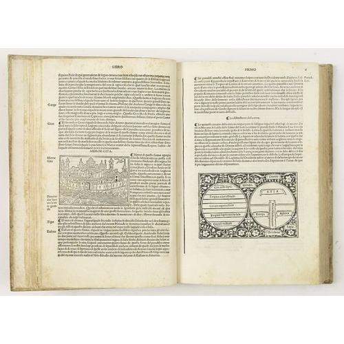
With large woodcut title-border, woodcut border on leaf A1 and 107 (2 full-page) woodcuts with city views in several sizes including a version of the 'T-O' world map (Shirley, world plate 2).
Page 342 including an account of the discovery of America under the year 1493.
Richly illustrated Chronicle with a very nice full page wood block engraving of Adam and Eve, Tower of Babel, and 90 town views of Rome, Milan, Tripoli, Jerusalem, Paris, Geneva, Lisbon, Fiesole, Ravenna, Venice, Alexandria, Florence, Naples, Verona, Alexandria, Lisbon, Constantinople.
Giacomo Filippo Foresti da Bergamo (1434-1520) was an Augustinian monk, known as the author of several significant early printed works.
He was a chronicler and Biblical scholar.
Page V has an nice presentation of Giacomo Foresti's Medieval style T-O World Map and Greek Zonal World Map (87 x 132mm).
The image depicts the two earliest standardized concepts for the mapping of the world, dating to the times of the Greeks and Romans. On the left is the so-called "Zonal" map of the world, a concept which dates to Pythagorus. On the right is the so-called T-O World Map.
According to Redney Shirley (The Mapping of the World, plate 2):
T-O model:: "By medieval times the globular form of the earth was recognized by most scholars and geographers. World maps of the Middle Ages were often expressed in the form of simple climatic diagrams (e.g. in the works of commentators such as Macrobius, Sacrobasco, or Lilius) or conceived as one of the numerous "T-O" maps. In these examples to O represents the boundary of the world, the horizontal stroke of the T the meridian running from the Don to the Nile, and the perpendicular axis (the T-O maps invariably being oriented with east at the top) the line of the Mediterranean.
T-O maps appeared in manuscripts from the early Middle Ages, and the very first printed world map, from a version of the seventh-century AD writer Isidore of Seville's Etymologiae published in 1472, is of this kind.
Pythagorus : According to Robert Clancy, in Mapping Antarctica:
A Five Hundred Year Record of Discovery at p. 67:Pythagoras (580-500 BC) believed the earth was divided into five zones - two frigid zones at the poles, two temperate zones and a torrid zone at the equator. He believed the equatorial zone formed an impassable barrier between the hemispheres.
Aristotle (384-322 BC) postulated that symmetry was nature's favored form and if the world was symmetrical, then a Great South Land must exist to counterbalance the lands of the north.
FAQ - Guarantee - Shipping
Buying in the BuyNow Gallery
This item is available for immediate purchase when a "Add to Cart" or "Inquire Now" button is shown.
Items are sold in the EU margin scheme
Payments are accepted in Euros or US Dollars.
FAQ
Please have a look for more information about buying in the BuyNow gallery
Many answers are likely to find in the general help section.
Like this item?
![]()
Thinking about buying later on?
Or create your virtual collection !
With Wishlist you can collect all Your Favorite maps in one place by simply pressing a button!
Add this item to
Wish List
See my WishList here. [ Read More ]
Authenticity Guarantee
 We provide professional descriptions, condition report and HiBCoR rating (based on 45 years experience in the map business)
We fully guarantee the authenticity of items we sell. We provide a certificate of authenticity for each purchased item.
Shipping fee
A flat shipping fee of $ 25 is added to each shipment within Europe and North America. This covers : International Priority shipping, Packing and Insurance (up to the invoice amount).
Shipments to Asia are $ 40 and rest of the world $50
We charge only one shipping fee when you have been successful on multiple items or when you want to combine gallery and auction purchases.
Read More about invoicing and shipping
| High-Resolution Digital Image Download | |
|
Paulus Swaen maintains an archive of most of our high-resolution rare maps, prints, posters and medieval manuscript scans. We make them freely available for download and study. Read more about free image download |
In accordance with the EU Consumer Rights Directive and habitually reside in the European Union you have the right to cancel the contract for the purchase of a lot, without giving any reason.
The cancellation period will expire 14 calendar days from the day after the date on which you or a third party (other than the carrier and indicated by you) acquires, physical possession of the lot. To exercise the right to cancel you must inform Paulus Swaen Europe bv, which is offering to sell the lot either as an agent for the seller or as the owner of the lot, of your decision to cancel this contract by a clear statement (e.g. a letter sent by post, or e-mail (amsterdam@swaen.com).
To meet the cancellation deadline, it is sufficient for you to send your communication concerning your exercise of the right to cancel before the cancellation period has expired.
