Subscribe to be notified if similar examples become available.
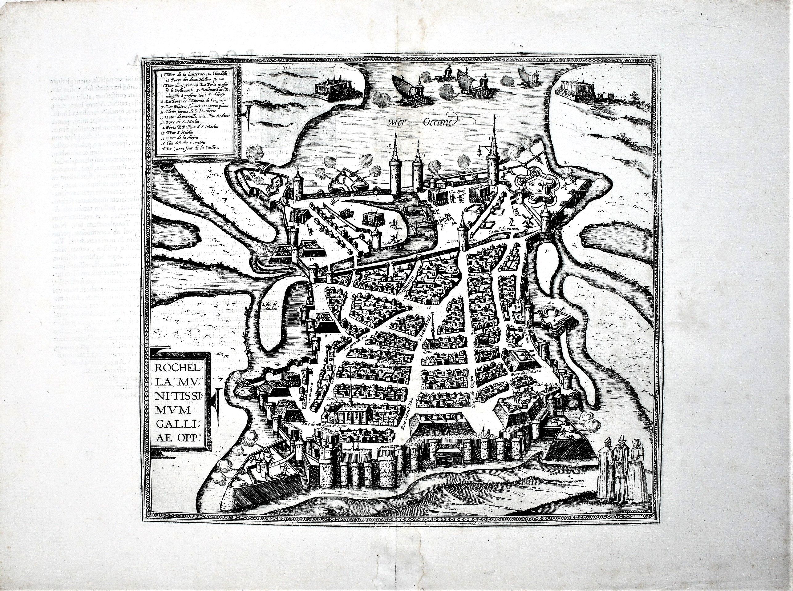
Rochella Munitissimum Galliae Opp. |
||||||||||||||||||||
|
||||||||||||||||||||
|
|
||||||||||||||||||||
|
Selling price: $88
Sold in 2022 Missed this item! Be the first to get notified about our newly added listings. Add your name to our mailing list. |
||||||||||||||||||||
Description
From the greatest publication in this genre!. The plates from Georg Braun and Frans Hogenberg's landmark Civitates Orbis Terrarum are the most valuable source for the study of Renaissance urban topography, and among the most evocative bird’s-eye ever published.
For the first time, the Civitates provided an extensive series of town views with the goal of rendering them in an accurate and meaningful way. Earlier collections of town views were far more limited in scope, and often made no real attempt to render cities with any degree of fidelity.
These works were more often an attempt to show that cities existed than to illustrate the form they took, and they normally contained no more than a handful of views. The Civitates, by contrast, included hundreds of views, many showing smaller towns for which no earlier topographical studies are known.
Even for the larger, important cities, such as Paris, the Civitates was of the utmost importance in tracing the history of their topography.
This massive collection was conceived to serve as a sort of companion work to the Theatrum Orbis Terrarum, the first modern world atlas, published by Abraham Ortelius in Antwerp beginning in 1570 (indeed, Hogenberg had first-hand knowledge of that impressive and influential work, having been commissioned by Ortelius to engrave many of the plates for the maps it included).
The text for the Civitates was compiled and written by Braun, the Canon of Cologne Cathedral, and a total of five hundred views were eventually included. The majority of the engraving was completed by Hogenberg and Simon Novellanus, many after drawings by Joris Hoefnagel, a talented topographical artist. For the Civitates, drawings and plans were solicited from the best artists and mapmakers from all over Europe.
As a result, it took over forty years to collect the hundreds of plans contained in the folio volumes that form the complete work. The artistic merit of this particular plate is extremely high, and it reflects many of the same high standards of quality, in terms of color, engraving, and decoration, that characterizes the maps of Ortelius.
More about Braun and Hogenberg, Civitatus [+]
FAQ - Guarantee - Shipping
Buying in the BuyNow Gallery
This item is available for immediate purchase when a "Add to Cart" or "Inquire Now" button is shown.
Items are sold in the EU margin scheme
Payments are accepted in Euros or US Dollars.
Authenticity Guarantee
 We provide professional descriptions, condition report and HiBCoR rating (based on 45 years experience in the map business)
We fully guarantee the authenticity of items we sell. We provide a certificate of authenticity for each purchased item.
Condition / Coloring
We indicate the condition of each item and use our unnique HiBCoR grading system in which four key items determine a map's value: Historical Importance, Beauty, Condition/Coloring and Rarity.
We offer many maps in their original black and white condition. We do not systematically color-up maps to make them more sellable to the general public or buyer.
Copper engraved or wood block maps are always hand colored. Maps were initially colored for aesthetic reasons and to improve readability. Nowadays, it is becoming a challenge to find maps in their original colors and are therefor more valuable.
We use the following color keys in our catalog:
Original colors; mean that the colors have been applied around the time the map was issued.
Colored; If the colors are applied recently or at the end of the 20th century, then "colored", or "attractive colors" will be used.
Original o/l colors; means the map has only the borders colored at the time of publication.
Read more about coloring of maps [+]
FAQ
Please have a look for more information about buying in the BuyNow gallery.
Many answers are likely to find in the general help section.
Like this item?
![]()
Thinking about buying later on?
Or create your virtual collection !
With Wishlist you can collect all Your Favorite maps in one place by simply pressing a button!
Add this item to
Wish List
See my WishList here. [ Read More ]
Invoice
The invoice and certificates of authenticity are available in the client center >Invoices
Shipping fee
A flat shipping fee of $ 25 is added to each shipment within Europe and North America. This covers : International Priority shipping, Packing and Insurance (up to the invoice amount).
Shipments to Asia are $ 40 and rest of the world $50
We charge only one shipping fee when you have been successful on multiple items or when you want to combine gallery and auction purchases.
Read more about invoicing and shipping
| High-Resolution Digital Image Download | |
|
Paulus Swaen maintains an archive of most of our high-resolution rare maps, prints, posters and medieval manuscript scans. We make them freely available for download and study. Read more about free image download |
Click this image for a free HR-image download. |
In accordance with the EU Consumer Rights Directive and habitually reside in the European Union you have the right to cancel the contract for the purchase of a lot, without giving any reason.
The cancellation period will expire 14 calendar days from the day after the date on which you or a third party (other than the carrier and indicated by you) acquires, physical possession of the lot. To exercise the right to cancel you must inform Paulus Swaen Europe bv, which is offering to sell the lot either as an agent for the seller or as the owner of the lot, of your decision to cancel this contract by a clear statement (e.g. a letter sent by post, or e-mail (amsterdam@swaen.com).
To meet the cancellation deadline, it is sufficient for you to send your communication concerning your exercise of the right to cancel before the cancellation period has expired.