Subscribe to be notified if similar examples become available.
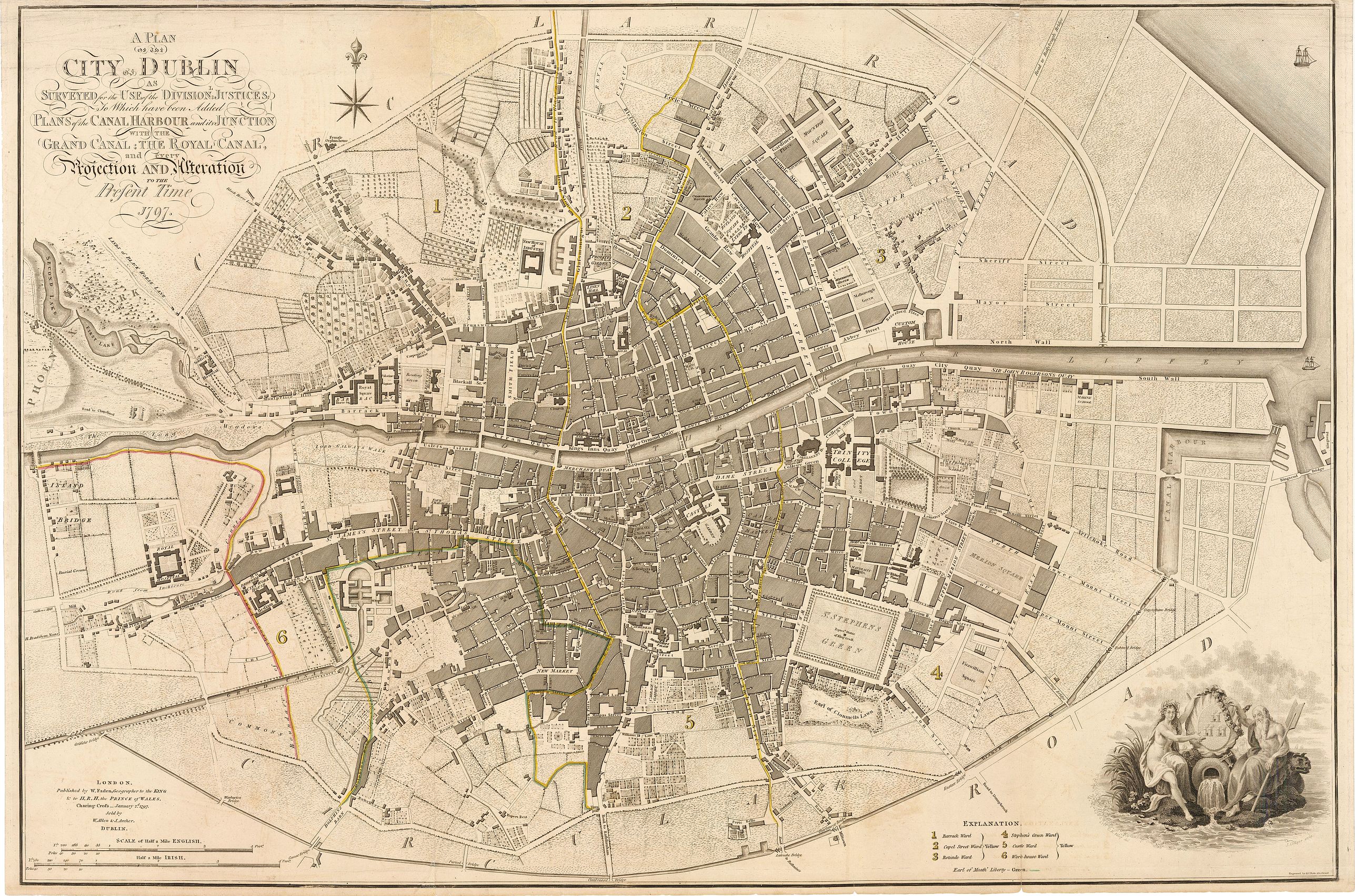
Plan of the City of Dublin Surveyed for Use of the Division of Justices, to Which have been Added Plans of the Canal Harbor and its Junction with the Grand Canal... |
||||||||||||||||||||
|
||||||||||||||||||||
|
|
||||||||||||||||||||
|
Selling price: $1600
Sold in 2023 Missed this item! Be the first to get notified about our newly added listings. Add your name to our mailing list. |
||||||||||||||||||||
Description
This is a rare separately issued map of Dublin, Ireland as it was at the end of what can be considered a rather prosperous century for the nation's capital and largest city. As noted in the map, it was published by William Faden, Geographer to the King and sold by W. Allen & J. Archer, Dublin.
Full title : Plan of the City of Dublin Surveyed for Use of the Division of Justices, to Which have been Added Plans of the Canal Harbor and its Junction with the Grand Canal; The Royal Canal and every Projection and Alteration of the Present Time.
The map centers on the River Liffey, or what is more commonly referred today as Temple Bar. The plan presents the city divided into six wards, Barrack, Capel Street, Rotunde, Stephen's Green, Castle, and Work-house ward, with the "Earl of Meath's Liberty outlined in Green. During the 18th century, otherwise known as the Georgian Period, Dublin experienced decades of steady growth and improvements and for a time, Dublin was the second largest city of the British Empire and the fifth largest city in Europe, with the population exceeding 130,000. The vast majority of Dublin's most notable architecture shown in this map dates from the Georgian Period.
Historical buildings and landmarks found throughout the map include...
- Trinity College: Founded in 1592 by Queen Elizabeth I as "the mother of a university."
- St. Stephen's Green: Established in the 17th century but restricted to local residents until 1877.
- Dublin Castle: Originally founded as a major defensive work on the orders of King John of England in 1204, completed in 1230.
- St. Patrick's Cathedral: Founded in 1191 as the National Cathedral of the Church of Ireland.
- Guinness Brewery: Though not specifically labeled, a small building on a large plot of land on the corner Ransford st. and Belview Crane St. marks the location of the St. James Gate Brewery founded forty years prior to the publication of this map (in 1759) when Arthur Guinness signed a 9,000 year lease at 45 pounds / year. The Brewery would eventually expand from 1 acre to over 64 acres, becoming the largest brewery in the world and the largest employer in Dublin.
Today the city is at the forefront of Ireland's economic expansion and as of late has boasted very low unemployment rate as it attracts visitors from around the world to enjoy its historical streets, architecture, landmarks, Celtic cultural, and of course a pint of Guinness.
FAQ - Guarantee - Shipping
Buying in the BuyNow Gallery
This item is available for immediate purchase when a "Add to Cart" or "Inquire Now" button is shown.
Items are sold in the EU margin scheme
Payments are accepted in Euros or US Dollars.
Authenticity Guarantee
 We provide professional descriptions, condition report and HiBCoR rating (based on 45 years experience in the map business)
We fully guarantee the authenticity of items we sell. We provide a certificate of authenticity for each purchased item.
Condition / Coloring
We indicate the condition of each item and use our unnique HiBCoR grading system in which four key items determine a map's value: Historical Importance, Beauty, Condition/Coloring and Rarity.
We offer many maps in their original black and white condition. We do not systematically color-up maps to make them more sellable to the general public or buyer.
Copper engraved or wood block maps are always hand colored. Maps were initially colored for aesthetic reasons and to improve readability. Nowadays, it is becoming a challenge to find maps in their original colors and are therefor more valuable.
We use the following color keys in our catalog:
Original colors; mean that the colors have been applied around the time the map was issued.
Colored; If the colors are applied recently or at the end of the 20th century, then "colored", or "attractive colors" will be used.
Original o/l colors; means the map has only the borders colored at the time of publication.
Read more about coloring of maps [+]
FAQ
Please have a look for more information about buying in the BuyNow gallery.
Many answers are likely to find in the general help section.
Like this item?
![]()
Thinking about buying later on?
Or create your virtual collection !
With Wishlist you can collect all Your Favorite maps in one place by simply pressing a button!
Add this item to
Wish List
See my WishList here. [ Read More ]
Invoice
The invoice and certificates of authenticity are available in the client center >Invoices
Shipping fee
A flat shipping fee of $ 25 is added to each shipment within Europe and North America. This covers : International Priority shipping, Packing and Insurance (up to the invoice amount).
Shipments to Asia are $ 40 and rest of the world $50
We charge only one shipping fee when you have been successful on multiple items or when you want to combine gallery and auction purchases.
Read more about invoicing and shipping
| High-Resolution Digital Image Download | |
|
Paulus Swaen maintains an archive of most of our high-resolution rare maps, prints, posters and medieval manuscript scans. We make them freely available for download and study. Read more about free image download |
Click this image for a free HR-image download. |
In accordance with the EU Consumer Rights Directive and habitually reside in the European Union you have the right to cancel the contract for the purchase of a lot, without giving any reason.
The cancellation period will expire 14 calendar days from the day after the date on which you or a third party (other than the carrier and indicated by you) acquires, physical possession of the lot. To exercise the right to cancel you must inform Paulus Swaen Europe bv, which is offering to sell the lot either as an agent for the seller or as the owner of the lot, of your decision to cancel this contract by a clear statement (e.g. a letter sent by post, or e-mail (amsterdam@swaen.com).
To meet the cancellation deadline, it is sufficient for you to send your communication concerning your exercise of the right to cancel before the cancellation period has expired.