Subscribe to be notified if similar examples become available.
Nova Totius Terrarum Orbis Geographica ac Hydrographica Tabula |
||||||||||||||||||||
|
||||||||||||||||||||
|
|
||||||||||||||||||||
|
Selling price: $5100
Sold in 2021 Missed this item! Be the first to get notified about our newly added listings. Feel free to contact us if you have a question about this item. Add your name to our mailing list. |
Virtual Collection - Save and collect your favorite items in one place.
Unless logged in, the item is only saved for that session. If you want to save the items permanently, please Login first Learn more [+] |
|||||||||||||||||||
Description
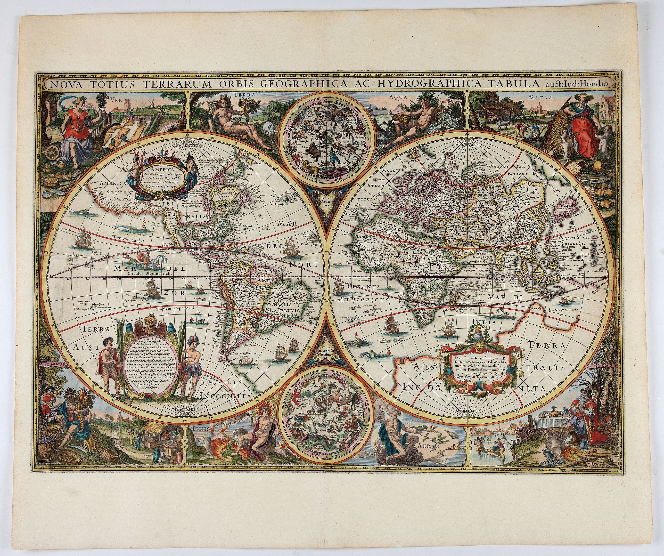
Symbols of the four elements, for seasons with Ver or Spring showing gardeners tending a formal Dutch garden, Aestas or Summer is the time for sheep-shearing, Autumn brings the grape harvest in for wine pressing and in Hymens or Winter skaters revel on a frozen lake.
In the upper and lower center two celestial orbs.
This edition with the date 1625 and the address of "M.Taverntier en Lisle du Palais A° 1625" was unknown to Shirley.
There are states known with the dates 1630 and 1638, who are according to Shirly included in the Théatre published in 1632 and 1634. The second state (now third state) was dated 1636 and is more commonly found and has a different address.
This is thus a separate publication. We were not able to trace another example with the date 1625.
The map is a close copy of the 1617 world map by Jodocus Hondius Jr. One of the most beautiful world maps ever engraved and one of the earliest maps to show the Dutch discoveries in Le Maire's Street.
This strait, and Cape Horn, were discovered in 1616 during the circumnavigation of Schouten and Le Maire. Subsequently Le Maire explored the north coast of New Guinea and this is shown on the right-hand hemisphere together with one of the new islands, Willem Schouten Eylant.
In the Pacific the islands called at by Le Maire are also marked.
In North America, the map is one of the first to delineate Hudson's Bay (after Gerritsz.), making special reference to Henry Hudson and the Dutch and English expeditions there up to 1612. The map extends the whole of the St. Lawrence river which runs across the continent, terminating in a large lake.
In spite of its restorations a very desirable item, which makes great presentation.
The below image does mark the repair areas.
Reference: Shirley, World 337
FAQ - Guarantee - Shipping
Buying in the BuyNow Gallery
This item is available for immediate purchase when a "Add to Cart" or "Inquire Now" button is shown.
Items are sold in the EU margin scheme
Payments are accepted in Euros or US Dollars.
Authenticity Guarantee
 We provide professional descriptions, condition report (based on 45 years experience in the map business)
Paulus Swaen warrants the authenticity of our items and a certificate of authenticity is provided for each acquired lot.
Condition and Coloring
We indicate the condition of each item and use our unnique HiBCoR grading system in which four key items determine a map's value: Historical Importance, Beauty, Condition/Coloring and Rarity.
Color Key
We offer many maps in their original black and white condition. We do not systematically color-up maps to make them more sellable to the general public or buyer.
Copper engraved or wood block maps are always hand colored. Maps were initially colored for aesthetic reasons and to improve readability. Nowadays, it is becoming a challenge to find maps in their original colors and are therefor more valuable.
We use the following color keys in our catalog:
Original colors; mean that the colors have been applied around the time the map was issued.
Original o/l colors; means the map has only the borders colored at the time of publication.
Colored; If the colors are applied recently or at the end of the 20th century.
Read more about coloring of maps [+]
Shipping fee
A flat shipping fee of $ 30 is added to each shipment by DHL within Europe and North America. This covers : International Priority shipping, Packing and Insurance (up to the invoice amount).
Shipments to Asia are $ 40 and rest of the world $50
We charge only one shipping fee when you have been successful on multiple items or when you want to combine gallery and auction purchases.
Read more about invoicing and shipping
FAQ
Please have a look for more information about buying in the BuyNow gallery
Many answers are likely to find in the general help section.
Virtual Collection
![]()
With Virtual Collection you can collect all your favorite items in one place. It is free, and anyone can create his or her Virtual map collection.
Unless you are logged in, the item is only saved for this session. You have to be registed and logged-in if you want to save this item permanently to your Virtual Collection.
Read More[+]
Register here, it is free and you do not need a credit card.
Add this item to
Virtual Collection
or click the following link to see my Virtual Collection.
| High-Resolution Digital Image Download | |
|
Paulus Swaen maintains an archive of most of our high-resolution rare maps, prints, posters and medieval manuscript scans. We make them freely available for download and study. Read more about free image download |
Click this image for a free HR-image download. |
In accordance with the EU Consumer Rights Directive and habitually reside in the European Union you have the right to cancel the contract for the purchase of a lot, without giving any reason.
The cancellation period will expire 14 calendar days from the day after the date on which you or a third party (other than the carrier and indicated by you) acquires, physical possession of the lot. To exercise the right to cancel you must inform Paulus Swaen Europe bv, which is offering to sell the lot either as an agent for the seller or as the owner of the lot, of your decision to cancel this contract by a clear statement (e.g. a letter sent by post, or e-mail (amsterdam@swaen.com).
To meet the cancellation deadline, it is sufficient for you to send your communication concerning your exercise of the right to cancel before the cancellation period has expired.