Subscribe to be notified if similar examples become available.
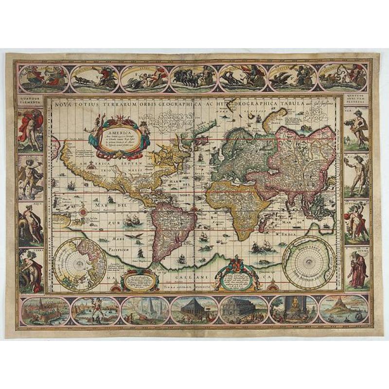
Nova totius terrarum orbis geographica ac hydrographica tabula. (Gul. Jansonius 1606) |
||||||||||||||||||||
|
||||||||||||||||||||
|
|
||||||||||||||||||||
|
Selling price: $10000
Sold Missed this item! Be the first to get notified about our newly added listings. Add your name to our mailing list. |
||||||||||||||||||||
Description
Jacob Le Maire and Willem Schouten discovered the strait in 1616, while attempting to find a navigation link between the Atlantic and Pacific Oceans, and shortly before their discovery of Cape Horn. The strait was named in honor of Le Maire.
Willem Blaeu updated in state 3 the map and Terra del Fuego is now an island and Fretum le Maire has been added.
Willem Janszoon, adopted the name Blaeu to avoid confusion with Jan Janszoon and altered his own name around 1621.
Exceptionally rare, Prof. Gunter Schilder notes in Monumenta Cartographica only 3 examples.
The paneled borders show, at the top allegorical representations of the sun, moon and the five known planets Mercury, Venus, Mars, Jupiter and Saturn. The four seasons and the four elements are depicted at each side and - along the bottom corner - seven vignettes showing the Seven Wonders of the World. Rodney Shirley writes It is celebrated as one of the supreme examples of the map maker's art... .
THE EXTREMELY RARE FIRST STATE. The states can be determined as follows:
- State 1. The image does not include the signature "Ja. vanden Ende sculpsit." to the lower left of the South Pole projection. Shirley says "possibly a proof".
- State 2. With signature of Josua van den Ende: "Ja. vanden Ende sculpsit"
- State 3. As state 2, but Terra del Fuego is now an island and Fretum le Maire has been added. Probably issued in 1617, as a companion map of Europe bears this date.
- State 4: "Gul. Jansonius 1606" removed and replaced with "Guil. Blaeuw". "Gulielmus Janssonius" replaced with "Gulielmus Blaeuw".
- State 5: Confusingly, this final state, unrecorded by Shirley, adds back the connection between Terra del Fuego and the Southern Continent and some of the coastline erased in the third state.
The geographic content is identical to that of the 1606/07 wall map. Because of the smaller size of the folio map, fewer toponyms are given and the number of legends has also been reduced. The centre of North America is taken up by a large oval cartouche containing a Latin text, here in translation: 'America. First discovered in A.D. 1492 by Christopher Colombus in the name of the king of Castille and given the name by Amerigo Vespucci in 1499'. The following legend, here in translation, is inserted in the area to the east of Novaya Zemlya: 'Novaya Zemlya. Discovered in 1596 by Willem Barentszoon from Amsterdam in the name of the States General of the Netherlands'.
Reference: Shirley, World 255, State 1.
FAQ - Guarantee - Shipping
Buying in the Buy-it-Now Gallery
This item is available for immediate purchase when a "Add to Cart" or "Inquire Now" button is shown.
Items are sold in the EU margin scheme
Payments are accepted in Euros or US Dollars.
FAQ
Please have a look for more information about buying in the Buy-It-Now gallery or about bidding at auction.
Many answers are likely to find in the general help section.
Like this item?
![]()
Thinking about buying later on?
Or create your virtual collection !
With Wishlist you can collect all Your Favorite maps in one place by simply pressing a button!
Add this item to
Wish List
See my WishList here. [ Read More ]
Authenticity Guarantee
 We provide professional descriptions, condition report and HiBCoR rating (based on 45 years experience in the map business)
We fully guarantee the authenticity of items we sell. We provide a certificate of authenticity for each purchased item.
Shipping fee
A flat shipping fee of € $ 30 is added to each shipment within Europe and North America. This covers : International Priority shipping, Packing and Insurance (up to the invoice amount).
Shipments to Asia are $ 40 and rest of the world $50
We charge only one shipping fee when you have been successful on multiple items or when you want to combine gallery and auction purchases.
Read More about invoicing and shipping
| High-Resolution Digital Image Download | |
|
Paulus Swaen maintains an archive of most of our high-resolution rare maps, prints, posters and medieval manuscript scans. We make them freely available for download and study. Read more about free image download |
In accordance with the EU Consumer Rights Directive and habitually reside in the European Union you have the right to cancel the contract for the purchase of a lot, without giving any reason.
The cancellation period will expire 14 calendar days from the day after the date on which you or a third party (other than the carrier and indicated by you) acquires, physical possession of the lot. To exercise the right to cancel you must inform Paulus Swaen Europe bv, which is offering to sell the lot either as an agent for the seller or as the owner of the lot, of your decision to cancel this contract by a clear statement (e.g. a letter sent by post, or e-mail (amsterdam@swaen.com).
To meet the cancellation deadline, it is sufficient for you to send your communication concerning your exercise of the right to cancel before the cancellation period has expired.

