Subscribe to be notified if similar examples become available.
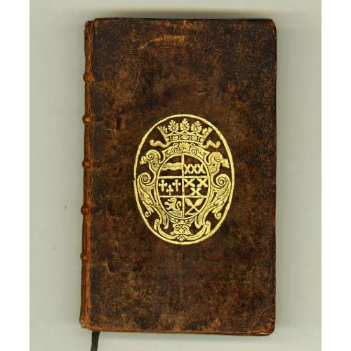
Memoires, historiques & geographiques du Royaume de la Moree, Negrepont, & des places maritimes jusques à Thessalonique. Recueillis & enrichis des cartes des païs & des plas des places. |
||||||||||||||||||||
|
||||||||||||||||||||
|
|
||||||||||||||||||||
|
Selling price: $6000
Sold Missed this item! Be the first to get notified about our newly added listings. Add your name to our mailing list. |
||||||||||||||||||||
Description
On both covers and gilted coats of arms and on inside engraved ex-libris of Louis-César dee Crémeaux, marquis d'Entragues (17..-1747), who was a lieutenant general in the government of Mâconnais and well-known bibliophile.
With a lovely engraved ex-libris of Pierre Claret de Fleurieu (1738-1810). He was born in Lyon on July 2nd, 1738. At the age of 17, he joined the navy and took part in several naval battles in the Mediterranean Sea, against England, during the "7 Year War", enabling him to be promoted to sub-Lieutenant in 1762.
The peace of 1763 gave him occasion to apply himself to office work and study, and he assisted the engineer Ferdinand Berthoud, in 1766, in his invention of the marine watch or chronometer.
In 1768 he was appointed to the command of the frigate "Isis" on an expedition to experiment with the new instrument, sailing from Aix in November of that year. He took observations at Martinique, Santo Domingo, Porto Rico, Havana, Jamaica, Colon, and New Orleans, and after touching at New York, Boston, and Newfoundland, returned to Aix on 11 October 1769.
The results of this expedition were important to geography, as he established the exact position of all +he points visited, and published them in his later works.
In 1776 Fleurieu was appointed inspector general of ports and navy yards, and from 1778 till 1783 he elaborated all the plans for the naval war against England, to assist the struggle for the independence of the United States. In 1790'1 he was minister of the navy, and in 1793 was imprisoned under the reign of terror, but was released in 1794, and under the directory was appointed to the bureau of longitudes. He was a member of the council of 500 in 1797, and in 1800 was called by Bonaparte to the council of state. In 1805 he was minister plenipotentiary for the signature of the treaty ceding Louisiana to the United States, and on his return became intendant of the imperial house, senator, in 1806 admiral, and in 1808 governor of the Tuileries.
The original Italian edition appeared earlier that same year, and the French translation by Barbin appeared in 1687 only. The work starts with a geographical description of the mountains and rivers of Greece, then it treats the various cities and isles of Greece, each with their own history, illustrated with plates of fortifications, views of cities and harbours.
At the time, Greece was in the centre of Europe's interest for it was the battle-field where the Venetian Republic defeated the Turks, pushing the ever threatening Ottoman Empire back to their own territory. The battle between Venice and the Turks of 1685 and the victory of the Venetian army in 1686 are also described.
The present edition is richly illustrated with nice maps, plans and views of Greece.
Reference: Blackmer Coll. 407. not in Tiele.
FAQ - Guarantee - Shipping
Buying in the BuyNow Gallery
This item is available for immediate purchase when a "Add to Cart" or "Inquire Now" button is shown.
Items are sold in the EU margin scheme
Payments are accepted in Euros or US Dollars.
FAQ
Please have a look for more information about buying in the BuyNow gallery
Many answers are likely to find in the general help section.
Like this item?
![]()
Thinking about buying later on?
Or create your virtual collection !
With Wishlist you can collect all Your Favorite maps in one place by simply pressing a button!
Add this item to
Wish List
See my WishList here. [ Read More ]
Authenticity Guarantee
 We provide professional descriptions, condition report and HiBCoR rating (based on 45 years experience in the map business)
We fully guarantee the authenticity of items we sell. We provide a certificate of authenticity for each purchased item.
Shipping fee
A flat shipping fee of $ 25 is added to each shipment within Europe and North America. This covers : International Priority shipping, Packing and Insurance (up to the invoice amount).
Shipments to Asia are $ 40 and rest of the world $50
We charge only one shipping fee when you have been successful on multiple items or when you want to combine gallery and auction purchases.
Read More about invoicing and shipping
| High-Resolution Digital Image Download | |
|
Paulus Swaen maintains an archive of most of our high-resolution rare maps, prints, posters and medieval manuscript scans. We make them freely available for download and study. Read more about free image download |
In accordance with the EU Consumer Rights Directive and habitually reside in the European Union you have the right to cancel the contract for the purchase of a lot, without giving any reason.
The cancellation period will expire 14 calendar days from the day after the date on which you or a third party (other than the carrier and indicated by you) acquires, physical possession of the lot. To exercise the right to cancel you must inform Paulus Swaen Europe bv, which is offering to sell the lot either as an agent for the seller or as the owner of the lot, of your decision to cancel this contract by a clear statement (e.g. a letter sent by post, or e-mail (amsterdam@swaen.com).
To meet the cancellation deadline, it is sufficient for you to send your communication concerning your exercise of the right to cancel before the cancellation period has expired.

