Subscribe to be notified if similar examples become available.
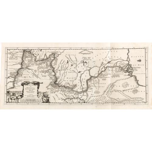
Le Cours de la Riviere de Wolga Anciennement appellee RHA. Selon la Relation d'Olearius. |
||||||||||||||||||||
|
||||||||||||||||||||
|
|
||||||||||||||||||||
|
Selling price: $1000
Sold in 2016 Missed this item! Be the first to get notified about our newly added listings. Add your name to our mailing list. |
||||||||||||||||||||
Description
Olearius's map of the lower Volga is the most important map 17th Century map of the River. Decorative cartouche lower left with travelers outside Astrakhan, Persia’s city at the mouth of the Volga. A camel and a Tatar wagon appear in the foreground of the view, where Tatar merchants set out their wares.
Olearius participated in an embassy to Moscow and later to Persia, in an attempt to secure for Frederick III a favorable position at the end of the Silk Route.
He travelled extensively in Russia and Persia, meeting with the Czar and the Shah. The party's descent of the Volga resulted in the first detailed mapping of the river and Olearius' account of the expedition, first published in German in 1646 and translated into French in 1656 and again in 1659, is one of the most important early accounts of European travels in Russia.
Olearius map of the Volga is the most accurate 17th century map of the lower Volga river valley, then a key area along Europe’s eastern frontier. “There is no comparing Olearius’ Volga with those primitive representations seen on earlier maps, such as those of Massa and Visscher“ (Bagrow). Olearius' map was quickly copied by Jansson and was widely copied by other makers (with significantly less embellishment and detail) for the next 60+ years.
The map is based upon a manuscript map created by Olearius himself. When he returned to Moscow and presented the map to Czar Michael Romanov, the Czar was offered Olearius a position as court astronomer (which Olearius refused).
Olearius’ mission as ambassador was to secure permission to use the Volga as a trade route to Persia, and so his accurate charting of the route was of vital importance. He observed that: “since in my opinion this river is one of the largest, longest and most remarkable in the world, I have explored it assiduously with the help of an expert Dutch navigator, Cornelius Clausen, and some Russian pilots: and reduced it to a map with the aid of compass, showing not only its course, its bends, angles and shores, but also its depths so as to indicate where one can navigate freely and safely, its sand banks, islands in it, and countries along its shores: and I measured the distances in miles and even in versts.
FAQ - Guarantee - Shipping
Buying in the Buy-it-Now Gallery
This item is available for immediate purchase when a "Add to Cart" or "Inquire Now" button is shown.
Items are sold in the EU margin scheme
Payments are accepted in Euros or US Dollars.
FAQ
Please have a look for more information about buying in the Buy-It-Now gallery or about bidding at auction.
Many answers are likely to find in the general help section.
Like this item?
![]()
Thinking about buying later on?
Or create your virtual collection !
With Wishlist you can collect all Your Favorite maps in one place by simply pressing a button!
Add this item to
Wish List
See my WishList here. [ Read More ]
Authenticity Guarantee
 We provide professional descriptions, condition report and HiBCoR rating (based on 45 years experience in the map business)
We fully guarantee the authenticity of items we sell. We provide a certificate of authenticity for each purchased item.
Shipping fee
A flat shipping fee of € $ 30 is added to each shipment within Europe and North America. This covers : International Priority shipping, Packing and Insurance (up to the invoice amount).
Shipments to Asia are $ 40 and rest of the world $50
We charge only one shipping fee when you have been successful on multiple items or when you want to combine gallery and auction purchases.
Read More about invoicing and shipping
| High-Resolution Digital Image Download | |
|
Paulus Swaen maintains an archive of most of our high-resolution rare maps, prints, posters and medieval manuscript scans. We make them freely available for download and study. Read more about free image download |
In accordance with the EU Consumer Rights Directive and habitually reside in the European Union you have the right to cancel the contract for the purchase of a lot, without giving any reason.
The cancellation period will expire 14 calendar days from the day after the date on which you or a third party (other than the carrier and indicated by you) acquires, physical possession of the lot. To exercise the right to cancel you must inform Paulus Swaen Europe bv, which is offering to sell the lot either as an agent for the seller or as the owner of the lot, of your decision to cancel this contract by a clear statement (e.g. a letter sent by post, or e-mail (amsterdam@swaen.com).
To meet the cancellation deadline, it is sufficient for you to send your communication concerning your exercise of the right to cancel before the cancellation period has expired.
