Subscribe to be notified if similar examples become available.
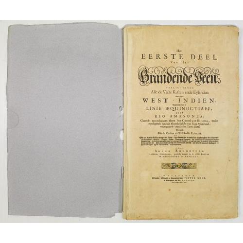
Het eerste deel van het Brandende Veen. . . |
||||||||||||||||||||
|
||||||||||||||||||||
|
|
||||||||||||||||||||
|
Selling price: $5100
Sold in 2008 Missed this item! Be the first to get notified about our newly added listings. Add your name to our mailing list. |
||||||||||||||||||||
Description
Unbound, but all leaves in very good condition with just some slight age toning.
Despite the missing pages, still a fascinating original source. The one single page map that is present, is the map of the Island Santa Catalina, near the coasts of Panama and Nicaragua. The famous pirate Henry Morgan used Santa Catalina as his base during the years 1670-1689. It was from Santa Catalina that Henry Morgan prepared and started his famous attack on San Lorenzo, followed by the taking of Panama City. Roggeveen mentions that pirates and privateers frequently use the Island, which is probably why he added this map of the otherwise insignificant Island in his Atlas.
The complete title of the work is Roggeveen, Arent: Het eerste deel van het Brandende Veen: verlichtende alle de vaste kusten ende eylanden van geheel West-Indien, beginnende van de linie aequinoctiael, ofte Rio Amasones: gaende noor-waert door het Canael van Bahama, ende eyndigende aan het noordelijckste van Nieu-Nederland, voortgaande benoorden Tarra-Neuf, Als meede alle de Caribes en West-Indise eylanden (..)
Roggeveen, worked as a cartographer for the Dutch West- and East Indies companies.
In the mid 1660?s, Roggeveen embarked upon compiling a series of large scale-charts of the North American coastline and West Indies. Many of his charts are based upon the earlier large-scale work of Hessel Gerritsz and Joan Vingboons - both cartographers for the Dutch East and West India Companies, but Roggeveen?s work was the first to show the whole coastline of North America and the Caribbean. He called this pilot "Het Brandende Veen" or "The burning Fen", a pun on his name as "veen" means "fen" and a heap of burning fen represents a fire on the coast to guide or warn ships.
Roggeveen's charts are now extraordinarily rare and are seldom seen on the market today. This is partly due to the inherent low survival rates of sea charts and pilots used aboard ships, and partly because Roggeveen?s publisher, Pieter Goos of Amsterdam, died in the year of the books publication (1675) and Arent Roggenveen died in 1679. The so-called "Burning Fen" is the most interesting of all the maritime works produced by Pieter Goos (Koeman).
Reference: Koeman Rog
Reference: Koeman, Atlantes Neerlandici, Rog 1.
FAQ - Guarantee - Shipping
Buying in the BuyNow Gallery
This item is available for immediate purchase when a "Add to Cart" or "Inquire Now" button is shown.
Items are sold in the EU margin scheme
Payments are accepted in Euros or US Dollars.
FAQ
Please have a look for more information about buying in the BuyNow gallery
Many answers are likely to find in the general help section.
Like this item?
![]()
Thinking about buying later on?
Or create your virtual collection !
With Wishlist you can collect all Your Favorite maps in one place by simply pressing a button!
Add this item to
Wish List
See my WishList here. [ Read More ]
Authenticity Guarantee
 We provide professional descriptions, condition report and HiBCoR rating (based on 45 years experience in the map business)
We fully guarantee the authenticity of items we sell. We provide a certificate of authenticity for each purchased item.
Shipping fee
A flat shipping fee of $ 25 is added to each shipment within Europe and North America. This covers : International Priority shipping, Packing and Insurance (up to the invoice amount).
Shipments to Asia are $ 40 and rest of the world $50
We charge only one shipping fee when you have been successful on multiple items or when you want to combine gallery and auction purchases.
Read More about invoicing and shipping
| High-Resolution Digital Image Download | |
|
Paulus Swaen maintains an archive of most of our high-resolution rare maps, prints, posters and medieval manuscript scans. We make them freely available for download and study. Read more about free image download |
In accordance with the EU Consumer Rights Directive and habitually reside in the European Union you have the right to cancel the contract for the purchase of a lot, without giving any reason.
The cancellation period will expire 14 calendar days from the day after the date on which you or a third party (other than the carrier and indicated by you) acquires, physical possession of the lot. To exercise the right to cancel you must inform Paulus Swaen Europe bv, which is offering to sell the lot either as an agent for the seller or as the owner of the lot, of your decision to cancel this contract by a clear statement (e.g. a letter sent by post, or e-mail (amsterdam@swaen.com).
To meet the cancellation deadline, it is sufficient for you to send your communication concerning your exercise of the right to cancel before the cancellation period has expired.

