Subscribe to be notified if similar examples become available.
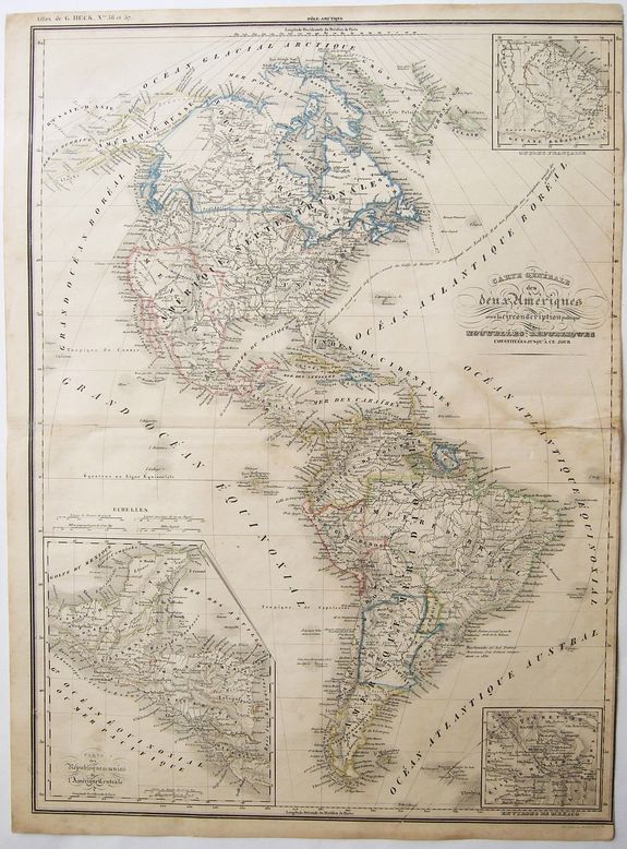
CARTE GENERALE des Deux Ameriques. |
||||||||||||||||||||
|
||||||||||||||||||||
|
|
||||||||||||||||||||
|
Selling price: $60
Sold in 2021 Missed this item! Be the first to get notified about our newly added listings. Add your name to our mailing list. |
Virtual Collection - Save and collect your favorite items in one place.
Unless logged in, the item is only saved for that session. If you want to save the items permanently, please Login first Learn more [+] |
|||||||||||||||||||
Description
There are 3 inset maps of - the 'Federal Republic of Central America' [Guatemala, Honduras, Nicaragua, Costa Rica, El Salvador and southern Mexico] - the environs of Mexico City - and French Guyana.
Also, amongst other, shows a large Republic of Colombia, including todays Venezuela Colombia Panama and Ecuador. Bolivia is still shown with access to the Pacific Ocean, and Patagonia not yet incorporated into the Argentine.
The Federal Republic of Central America (Spanish: República Federal de Centroamérica), also called the United Provinces of Central America (Provincias Unidas del Centro de América) in its first year of creation, was a sovereign state in Central America that consisted of the territories of the former Captaincy General of Guatemala of New Spain. It existed from July 1823 to February 1841, as a republican democracy.
The republic consisted of the present-day Central American countries of Costa Rica, El Salvador, Guatemala, Honduras, and Nicaragua, and the southern Mexican state of Chiapas. In the 1830s, a sixth state was added – Los Altos, with its capital in Quetzaltenango – occupying parts of what are now the western highlands of Guatemala and Chiapas.
Shortly after Central America declared independence from the Spanish Empire in 1821, some of its countries were annexed by the First Mexican Empire in 1822 and then Central America formed the Federal Republic in 1823. From 1838 to 1840, the federation descended into civil war, with conservatives fighting against liberals and separatists fighting to secede.
These factions were unable to overcome their ideological differences and the federation was dissolved after a series of bloody conflicts.
Reference: [Wikipedia]
FAQ - Guarantee - Shipping
Buying in the BuyNow Gallery
This item is available for immediate purchase when a "Add to Cart" or "Inquire Now" button is shown.
Items are sold in the EU margin scheme
Payments are accepted in Euros or US Dollars.
Authenticity Guarantee
 We provide professional descriptions, condition report (based on 45 years experience in the map business)
Paulus Swaen warrants the authenticity of our items and a certificate of authenticity is provided for each acquired lot.
Condition and Coloring
We indicate the condition of each item and use our unnique HiBCoR grading system in which four key items determine a map's value: Historical Importance, Beauty, Condition/Coloring and Rarity.
Color Key
We offer many maps in their original black and white condition. We do not systematically color-up maps to make them more sellable to the general public or buyer.
Copper engraved or wood block maps are always hand colored. Maps were initially colored for aesthetic reasons and to improve readability. Nowadays, it is becoming a challenge to find maps in their original colors and are therefor more valuable.
We use the following color keys in our catalog:
Original colors; mean that the colors have been applied around the time the map was issued.
Original o/l colors; means the map has only the borders colored at the time of publication.
Colored; If the colors are applied recently or at the end of the 20th century.
Read more about coloring of maps [+]
Shipping fee
A flat shipping fee of $ 30 is added to each shipment by DHL within Europe and North America. This covers : International Priority shipping, Packing and Insurance (up to the invoice amount).
Shipments to Asia are $ 40 and rest of the world $50
We charge only one shipping fee when you have been successful on multiple items or when you want to combine gallery and auction purchases.
Read more about invoicing and shipping
FAQ
Please have a look for more information about buying in the BuyNow gallery
Many answers are likely to find in the general help section.
Virtual Collection
![]()
With Virtual Collection you can collect all your favorite items in one place. It is free, and anyone can create his or her Virtual map collection.
Unless you are logged in, the item is only saved for this session. You have to be registed and logged-in if you want to save this item permanently to your Virtual Collection.
Read More[+]
Register here, it is free and you do not need a credit card.
Add this item to
Virtual Collection
or click the following link to see my Virtual Collection.
| High-Resolution Digital Image Download | |
|
Paulus Swaen maintains an archive of most of our high-resolution rare maps, prints, posters and medieval manuscript scans. We make them freely available for download and study. Read more about free image download |
Click this image for a free HR-image download. |
In accordance with the EU Consumer Rights Directive and habitually reside in the European Union you have the right to cancel the contract for the purchase of a lot, without giving any reason.
The cancellation period will expire 14 calendar days from the day after the date on which you or a third party (other than the carrier and indicated by you) acquires, physical possession of the lot. To exercise the right to cancel you must inform Paulus Swaen Europe bv, which is offering to sell the lot either as an agent for the seller or as the owner of the lot, of your decision to cancel this contract by a clear statement (e.g. a letter sent by post, or e-mail (amsterdam@swaen.com).
To meet the cancellation deadline, it is sufficient for you to send your communication concerning your exercise of the right to cancel before the cancellation period has expired.