Subscribe to be notified if similar examples become available.
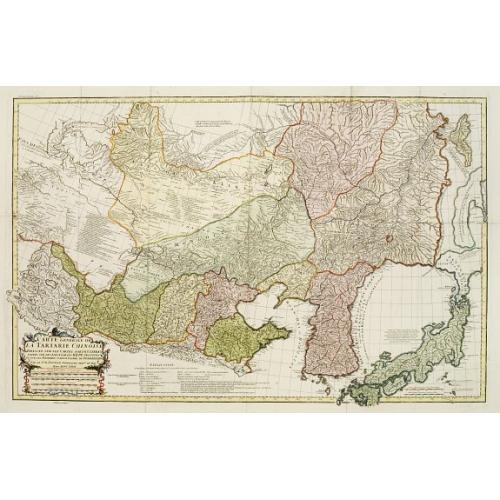
Carte Generale De La Tartarie Chinoise Dressee sur les Cartes Particulieres Faits Sur Les Lieux Par Les R.R. P.P. Jesuites . . . .MDCCXXXII |
||||||||||||||||||||
|
||||||||||||||||||||
|
|
||||||||||||||||||||
|
Selling price: $1800
Sold Missed this item! Be the first to get notified about our newly added listings. Add your name to our mailing list. |
||||||||||||||||||||
Description
Very detailed map of Northern China, Japan, and Korea. Jean Baptiste Bourguignon d' Anville (1697-1782), French cartographer. Compiled over 200 maps. This map is from his most important work," Nouvel Atlas de la Chine, published in The Hague 1737, "The principal cartographic authority on China during the 18th century." (Tooley)
d'Anville used maps prepared by Jesuit missionaries and commissioned by Emporer-Kangxi, who in 1708-1716 ordered a surveying of the country. Jean-Baptiste Regis (1664-1738), produced a map that came out in the Kangxi atlas and was used and edited by d'Anville and published in 1735 in du Halde (description de la Chine) and as "Royaume de Coree" (atlas de la Chine 1737). Despite broadening the southern part of the peninsula, this map was in the main accurate and was widely copied in the next 150 years (McCune 1977).
The map is important as it shows Dokdo as "Tchian-chan-tao," which is a Chinese pronunciation of "Usando," an old name of Dokdo, together with "Fan-ling-tao," a Chinese name for Ulleungdo Island. Korea is spelled by several names, including "Kaoli Koue" (country of Goryeo), "Royaume de Coree" (Kingdom of Korea), and "Tchao-Sien."
The map also gave reasonably accurate nomenclature of all eight provinces of Korea: "King-ki" (Gyeonggi-do Province), Kin Chan (Gyeongsang-do Province), "Hoang-hai" (Hwanghae-do Province), "Kiang-Yuen" (Gangwon-do Province), "Ping-Ngan" (Pyeongan-do Province) and "Hien-King" (Hamgyeong-do Province).
There are also faithful transcriptions of the regions around Seoul, including Cao-yang (Goyang) and "Yong haing" (Yangpyeong).
Jean Baptiste Bourguignon d'Anville (1697-1782) engraved his first map at the age of fifteen and produced many maps of high quality throughout his career. He became the finest cartographer of his time and carried on the French school of cartography developed by the Sanson and the de L'Isle families. Although he apparently never left Paris, he had access to the reports and maps of French explorers, traders, and missionaries. During his long career, he accumulated a large collection of cartographic materials that have been preserved. He was particularly interested in Asia and produced the first reasonably accurate map of China in 1735.
He became Royal Geographer and Cartographer to the King of France in the middle of the eighteenth century, when French cartography was still considered the best in the world. He was the successor to Guillaume Delisle as the chief proponent of scientific cartography, and his influence on his contemporaries was profound. D'Anville was the finest cartographer of his time, "his attention to detail was exemplary, his maps having a great delicacy of engraving" (Tooley).
More about Western mapping of Korea maps. [+]
Reference: OAG, Walter Japan Fig.39.
FAQ - Guarantee - Shipping
Buying in the BuyNow Gallery
This item is available for immediate purchase when a "Add to Cart" or "Inquire Now" button is shown.
Items are sold in the EU margin scheme
Payments are accepted in Euros or US Dollars.
FAQ
Please have a look for more information about buying in the BuyNow gallery
Many answers are likely to find in the general help section.
Like this item?
![]()
Thinking about buying later on?
Or create your virtual collection !
With Wishlist you can collect all Your Favorite maps in one place by simply pressing a button!
Add this item to
Wish List
See my WishList here. [ Read More ]
Authenticity Guarantee
 We provide professional descriptions, condition report and HiBCoR rating (based on 45 years experience in the map business)
We fully guarantee the authenticity of items we sell. We provide a certificate of authenticity for each purchased item.
Shipping fee
A flat shipping fee of $ 25 is added to each shipment within Europe and North America. This covers : International Priority shipping, Packing and Insurance (up to the invoice amount).
Shipments to Asia are $ 40 and rest of the world $50
We charge only one shipping fee when you have been successful on multiple items or when you want to combine gallery and auction purchases.
Read More about invoicing and shipping
| High-Resolution Digital Image Download | |
|
Paulus Swaen maintains an archive of most of our high-resolution rare maps, prints, posters and medieval manuscript scans. We make them freely available for download and study. Read more about free image download |
In accordance with the EU Consumer Rights Directive and habitually reside in the European Union you have the right to cancel the contract for the purchase of a lot, without giving any reason.
The cancellation period will expire 14 calendar days from the day after the date on which you or a third party (other than the carrier and indicated by you) acquires, physical possession of the lot. To exercise the right to cancel you must inform Paulus Swaen Europe bv, which is offering to sell the lot either as an agent for the seller or as the owner of the lot, of your decision to cancel this contract by a clear statement (e.g. a letter sent by post, or e-mail (amsterdam@swaen.com).
To meet the cancellation deadline, it is sufficient for you to send your communication concerning your exercise of the right to cancel before the cancellation period has expired.
