Subscribe to be notified if similar examples become available.
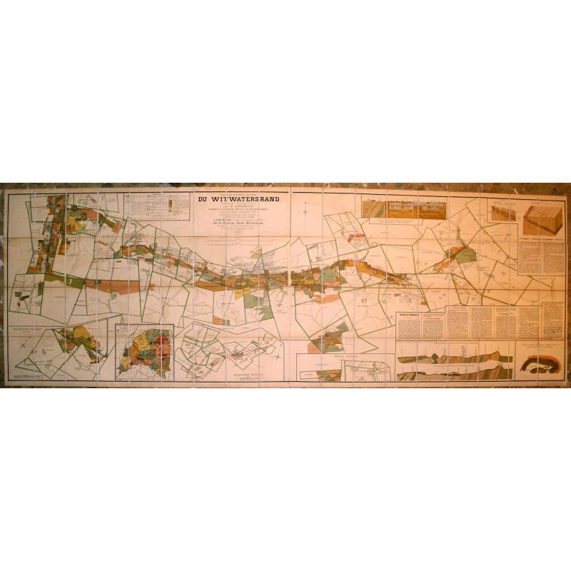
Carte Du District Aurifere Du Witwatersrand Transvaal (Afrique du Sud) Par S. Goldmann d'apres le Cadastre officiel du Gouvernement |
||||||||||||||||||||
|
||||||||||||||||||||
|
|
||||||||||||||||||||
|
Selling price: $1401
Sold in 2019 Missed this item! Be the first to get notified about our newly added listings. Add your name to our mailing list. |
||||||||||||||||||||
Description
Mineralogical survey dating from the early years of the mining of the huge gold reefs in the Witwatersrand Basin of South Africa. From the time when these deposits were discovered in 1886, South Africa became one of the world's major gold producers.
The Witwatersrand region, which forms the watershed between the Vaal and Olifants rivers, is c. 5 miles (40 km) wide and extends more than 60 miles (100 km) from west to east in a series of parallel ranges 5,000 to 6,000 ft (1,520--1,830 m) above sea level. The thin bands of gold ("reefs") are mined at depths of up to 10,000 ft (3,050 m). Founded as a mining settlement in 1886, Johannesburg already appears as a sizeable community 9 years later, when this map was published.
The large map (on a scale of 1:47,000) not only marks geological features but also townships and "mynpachts" (mining licenses). In addition to a general map of Transvaal (1:400,000), small inset maps depict the Heidelberg district, Klerksdorp district and the Northern extension, all of which were potentially lucrative parts of the Rand. Also included are a geologic cross-section of the land near Johannesburg and diagrams distinguishing between two types of mining companies --"deep-level" and "outcrop", with the mineral-rich veins highlighted with gold.
In his description of the region, Dupont mentions the estimates made by Counsellor Schmeisser, a special envoy sent by the German government to study the Rand. Schmeisser analyzed the central region of the ridge, which fell under the jurisdiction of one Boer-owned and another British-owned company. He estimated the minimum value of the gold that could be extracted over the coming 30-40 years at more than 7 billion German Marks (nearly 9 billion French francs). Extrapolating to include more of the ridge, Goldman optimistically triples or quadruples this figure.
Colonized by the Boers, Transvaal had become independent in 1881. The discovery of gold attracted many foreigners, especially Britons and Germans. Threatened by the economic success of the Dutch colony, the British settlers on the coast began a campaign of encirclement, hoping to gain control of the gold mines. In 1895, the same year that this map appeared in Paris, the infamous Jameson Raid was instigated against President Paul Kruger, and the increased tension that followed that aborted uprising led shortly thereafter to the Boer War (1899-1902). Henry Dupont published a number of other works on mining in South Africa, specifically analyzing the effects of the war on the Transvaal and the future of mining in the region. (source Martayan Lan)
The map was lithographed by Langonnet & Langlet, Paris.
Reference: OCLC lists one copy at the Bibl. Interuniversitaire Scientifique Jussieu (Paris).
FAQ - Guarantee - Shipping
Buying in the BuyNow Gallery
This item is available for immediate purchase when a "Add to Cart" or "Inquire Now" button is shown.
Items are sold in the EU margin scheme
Payments are accepted in Euros or US Dollars.
Authenticity Guarantee
 We provide professional descriptions, condition report (based on 45 years experience in the map business)
Paulus Swaen warrants the authenticity of our items and a certificate of authenticity is provided for each acquired lot.
Condition and Coloring
We indicate the condition of each item and use our unnique HiBCoR grading system in which four key items determine a map's value: Historical Importance, Beauty, Condition/Coloring and Rarity.
Color Key
We offer many maps in their original black and white condition. We do not systematically color-up maps to make them more sellable to the general public or buyer.
Copper engraved or wood block maps are always hand colored. Maps were initially colored for aesthetic reasons and to improve readability. Nowadays, it is becoming a challenge to find maps in their original colors and are therefor more valuable.
We use the following color keys in our catalog:
Original colors; mean that the colors have been applied around the time the map was issued.
Original o/l colors; means the map has only the borders colored at the time of publication.
Colored; If the colors are applied recently or at the end of the 20th century.
Read more about coloring of maps [+]
Shipping fee
A flat shipping fee of $ 30 is added to each shipment by DHL within Europe and North America. This covers : International Priority shipping, Packing and Insurance (up to the invoice amount).
Shipments to Asia are $ 40 and rest of the world $50
We charge only one shipping fee when you have been successful on multiple items or when you want to combine gallery and auction purchases.
Read more about invoicing and shipping
FAQ
Please have a look for more information about buying in the BuyNow gallery
Many answers are likely to find in the general help section.
Virtual Collection
![]()
With Virtual Collection you can collect all your favorite items in one place. It is free, and anyone can create his or her Virtual map collection.
Unless you are logged in, the item is only saved for this session. You have to be registed and logged-in if you want to save this item permanently to your Virtual Collection.
Read More[+]
Register here, it is free and you do not need a credit card.
Add this item to
Virtual Collection
or click the following link to see my Virtual Collection.
| High-Resolution Digital Image Download | |
|
Paulus Swaen maintains an archive of most of our high-resolution rare maps, prints, posters and medieval manuscript scans. We make them freely available for download and study. Read more about free image download |
In accordance with the EU Consumer Rights Directive and habitually reside in the European Union you have the right to cancel the contract for the purchase of a lot, without giving any reason.
The cancellation period will expire 14 calendar days from the day after the date on which you or a third party (other than the carrier and indicated by you) acquires, physical possession of the lot. To exercise the right to cancel you must inform Paulus Swaen Europe bv, which is offering to sell the lot either as an agent for the seller or as the owner of the lot, of your decision to cancel this contract by a clear statement (e.g. a letter sent by post, or e-mail (amsterdam@swaen.com).
To meet the cancellation deadline, it is sufficient for you to send your communication concerning your exercise of the right to cancel before the cancellation period has expired.

