Subscribe to be notified if similar examples become available.
Carte de la Mer de Dannemark et des Entrees dans la Mer Baltique |
||||||||||||||||||||
|
||||||||||||||||||||
|
|
||||||||||||||||||||
|
Selling price: $550
Sold in 2023 Missed this item! Be the first to get notified about our newly added listings. Add your name to our mailing list. |
||||||||||||||||||||
Description
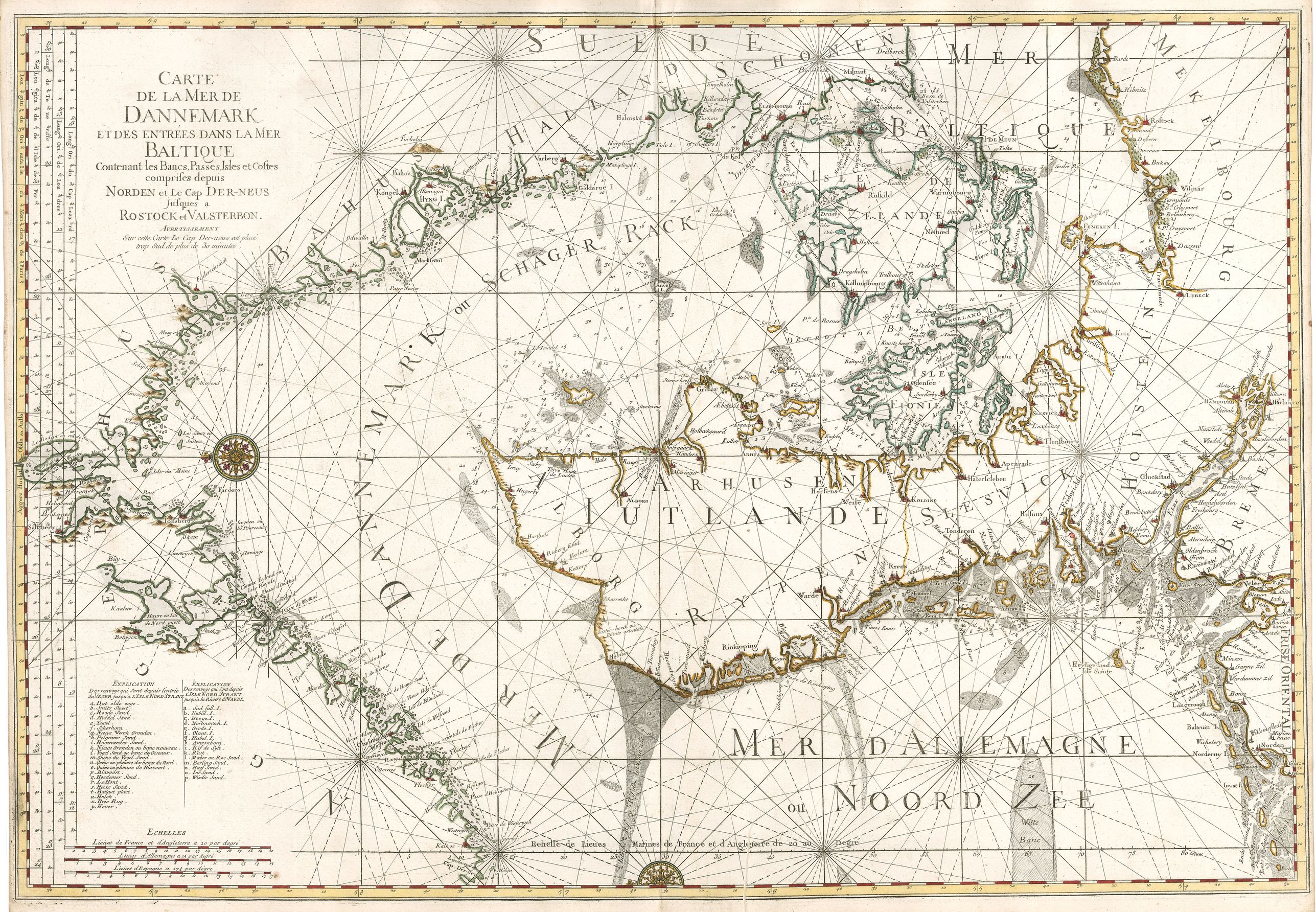
This magnificent, important sea chart is the work of French statesman Alexis-Hubert Jaillot. It is from the first edition of a French sea atlas entitled Neptune François, the first French atlas dedicated entirely to the its navy. Initiated by Jean-Baptist Colbert, the Minister and Secretary of State for the Navy for Louis XIV, this chart and other works from the atlas were widely copied and reissued for more than a century.
Oriented east, the chart shows the straits of Skagerrak and Kattegatt separating Sweden, Norway and Denmark, and part of the Baltic Sea between Nordenham and Rostock in Germany. Denmark is depicted in its entirety, and regions of the coasts of Norway, Sweden and Germany are included, with port cities named.
The surrounding seas are highly detailed with depth soundings, shoals and sandbanks all denoted. Rhumb lines radiate from the compasses and from other points throughout the chart. Three distance scales are shown, and two legends which identify coastal and shallow water are featured. Ornamental compass roses include one on the left of the map, and a half one at the lower center of the map.
FAQ - Guarantee - Shipping
Buying in the Buy-it-Now Gallery
This item is available for immediate purchase when a "Add to Cart" or "Inquire Now" button is shown.
Items are sold in the EU margin scheme
Payments are accepted in Euros or US Dollars.
FAQ
Please have a look for more information about buying in the BuyNow gallery.
Many answers are likely to find in the general help section.
Like this item?
![]()
Thinking about buying later on?
Or create your virtual collection !
With Wishlist you can collect all Your Favorite maps in one place by simply pressing a button!
Add this item to
Wish List
See my WishList here. [ Read More ]
Invoice
The invoice and certificates of authenticity are available in the client center >Invoices
Authenticity Guarantee
 We provide professional descriptions, condition report and HiBCoR rating (based on 45 years experience in the map business)
We fully guarantee the authenticity of items we sell. We provide a certificate of authenticity for each purchased item.
Shipping fee
A flat shipping fee of $ 25 is added to each shipment within Europe and North America. This covers : International Priority shipping, Packing and Insurance (up to the invoice amount).
Shipments to Asia are $ 40 and rest of the world $50
We charge only one shipping fee when you have been successful on multiple items or when you want to combine gallery and auction purchases.
Read More about invoicing and shipping
| High-Resolution Digital Image Download | |
|
Paulus Swaen maintains an archive of most of our high-resolution rare maps, prints, posters and medieval manuscript scans. We make them freely available for download and study. Read more about free image download |
Click this image for a free HR-image download. |
In accordance with the EU Consumer Rights Directive and habitually reside in the European Union you have the right to cancel the contract for the purchase of a lot, without giving any reason.
The cancellation period will expire 14 calendar days from the day after the date on which you or a third party (other than the carrier and indicated by you) acquires, physical possession of the lot. To exercise the right to cancel you must inform Paulus Swaen Europe bv, which is offering to sell the lot either as an agent for the seller or as the owner of the lot, of your decision to cancel this contract by a clear statement (e.g. a letter sent by post, or e-mail (amsterdam@swaen.com).
To meet the cancellation deadline, it is sufficient for you to send your communication concerning your exercise of the right to cancel before the cancellation period has expired.