Subscribe to be notified if similar examples become available.
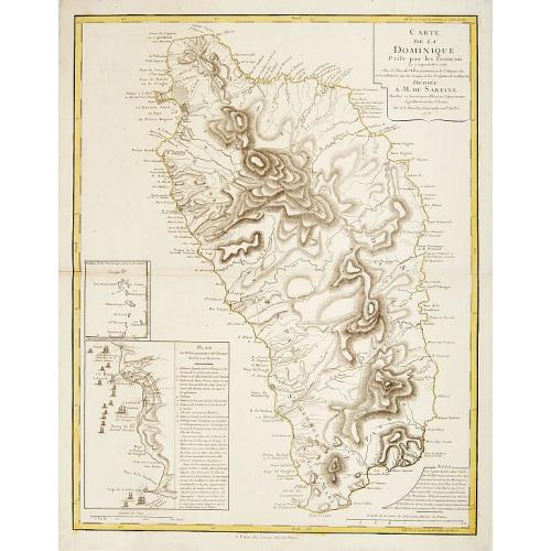
Carte de la Dominique prise par les François Le 7 septembre 1778. . . |
||||||||||||||||||||
|
||||||||||||||||||||
|
|
||||||||||||||||||||
|
Selling price: $850
Sold Missed this item! Be the first to get notified about our newly added listings. Add your name to our mailing list. |
||||||||||||||||||||
Description
This very finely engraved map depicts the French invasion of Dominica during the Revolutionary War, and captures the nature of this rugged Caribbean isle in great detail. Considered by many to be one of the most beautiful islands of the Caribbean, its intensely mountainous topography and fierce Caribbean inhabitants long resisted European settlement.
The present map shows the island divided into ten parishes, each outlined with its own color. The old capital of Portsmouth, with its streets laid out, is depicted in the north of the island, while the new capital, Roseau, and the nearby town of Charlottesville appear in the southwest. This area also features numerous fortifications, most notably Fort Cachacrou, that had been hastily built by the British to repel the expected French invasion. The map details anchorages, churches, villages and roads, and the mountains that dominate the island are expressed by finely engraved hatchings. The Caribbean native reservation, which still exists to this day, is depicted on the northeast coast.
Importantly, the large inset on the lower left of the map details the French naval invasion of the island which occurred on September 7th, 1778. France had recently declared hostilities on Britain, joining the Revolutionary War, and very much desired to capture Dominica in order to avenge their loss of the island to Britain in 1763. The French dispatched a massive invading force from Martinique under the Marquis de Bouillé, which consisted of almost 5,000 troops. The British line of fortifications that ran from just north of Roseau to Fort Cachacrou is portrayed in great detail. A key explains how the invasion unfolded, and indicated that the British commander Major Bruce, stood no chance against such an overwhelmingly superior force.
The British were soon forced to capitulate, and the French, with the support of the mainly Gallic citizenry, remained in firm possession of the island for the next few years. On April 12th, 1782 British Admiral George Romney decisively defeated the main French Caribbean fleet under the Comte de Grassee at the Battle of the Saints, within sight of Dominica's northern tip. While Romney did not land on Dominica, the French defeat ensured that they were forced to relinquish Dominica to the British in 1784, following the end of the war.
Jean Nicolas Buache, the Premier Géographe to Louis XVI, based this map on two works printed in London during the English occupation of the island. As stated on this map, he consulted John Byres's 1766 map which was the first to chart the interior of the island. He also consulted Thomas Jefferys's fine 1775 map of Dominica, which benefited from the results of the first triangulated surveys of the island conducted by the British from 1765 to 1773.
FAQ - Guarantee - Shipping
Buying in the Buy-it-Now Gallery
This item is available for immediate purchase when a "Add to Cart" or "Inquire Now" button is shown.
Items are sold in the EU margin scheme
Payments are accepted in Euros or US Dollars.
FAQ
Please have a look for more information about buying in the Buy-It-Now gallery or about bidding at auction.
Many answers are likely to find in the general help section.
Like this item?
![]()
Thinking about buying later on?
Or create your virtual collection !
With Wishlist you can collect all Your Favorite maps in one place by simply pressing a button!
Add this item to
Wish List
See my WishList here. [ Read More ]
Authenticity Guarantee
 We provide professional descriptions, condition report and HiBCoR rating (based on 45 years experience in the map business)
We fully guarantee the authenticity of items we sell. We provide a certificate of authenticity for each purchased item.
Shipping fee
A flat shipping fee of € $ 30 is added to each shipment within Europe and North America. This covers : International Priority shipping, Packing and Insurance (up to the invoice amount).
Shipments to Asia are $ 40 and rest of the world $50
We charge only one shipping fee when you have been successful on multiple items or when you want to combine gallery and auction purchases.
Read More about invoicing and shipping
| High-Resolution Digital Image Download | |
|
Paulus Swaen maintains an archive of most of our high-resolution rare maps, prints, posters and medieval manuscript scans. We make them freely available for download and study. Read more about free image download |
In accordance with the EU Consumer Rights Directive and habitually reside in the European Union you have the right to cancel the contract for the purchase of a lot, without giving any reason.
The cancellation period will expire 14 calendar days from the day after the date on which you or a third party (other than the carrier and indicated by you) acquires, physical possession of the lot. To exercise the right to cancel you must inform Paulus Swaen Europe bv, which is offering to sell the lot either as an agent for the seller or as the owner of the lot, of your decision to cancel this contract by a clear statement (e.g. a letter sent by post, or e-mail (amsterdam@swaen.com).
To meet the cancellation deadline, it is sufficient for you to send your communication concerning your exercise of the right to cancel before the cancellation period has expired.
