Subscribe to be notified if similar examples become available.
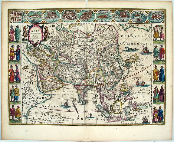
ASIA noviter delineata Autore Guiljelmo Blaeuw. |
||||||||||||||||||||
|
||||||||||||||||||||
|
|
||||||||||||||||||||
|
Selling price: $4850
Sold in 2011 Missed this item! Be the first to get notified about our newly added listings. Add your name to our mailing list. |
||||||||||||||||||||
Description
This map is basically a reduction of Blaeu's wallmap of Asia of 1608. The map contains extensive details on what was known of Asia in the early 17th century. Korea is still an island. Japan has a predominantly east to west direction. In China, the Great Wall is shown along with the in-land lakes.
Willem Janszoon, or Willem Jansz Blaeu (1571-1638) as he is more commonly known, was one of the most noted Dutch cartographers and map publisher of the 17th century. R.V. Tooley stated that Blaeu's maps are "esteemed by collectors for their decorative quality, historical importance, and as the highest expression of Dutch cartographic art during the period of its supremacy" (Tooley, p 28).
After preparation as a pupil of the great Danish astronomer,Tycho Brahe, Blaeu initially concentrated on globe making and separately published maps, including wall maps of the continents. From 1608, he dominated the market for sea atlases and in 1630 produced his terrestrial atlas. These atlases were continued by his sons, culminating in the great Atlas Maior of 1662 in 11 volumes with subsequent editions.
This particular map is from an early German edition of Blaeu's atlas of 1634 or 1635. This map first appeared in an atlas in Blaeu's Atlantis Appendix of 1630; it next appeared in this year of 1634/1635.
This map has German text on the verso with a signature of "C".
The map is in its 3rd state. The 1st state of 1617 was issued separately and has the name of "Willem Jansz" (not Blaeu) in the title cartouche. This state is rare and is virtually impossible to acquire. The 2nd state of 1621-30 has the name changed to "Guiljelmo Blaeuw" in the title. There is a 3rd state.
Reference: Tooley, Collectors' Guide to Maps of Africa, p.28-29. Krogt, Peter van der, Koeman's Atlantes Neerlandici, vol.II, p.591. Schilder, Gunter with Klaus Stopp, Monumenta Cartographica Neerlandica vol VI.
FAQ - Guarantee - Shipping
Buying in the BuyNow Gallery
This item is available for immediate purchase when a "Add to Cart" or "Inquire Now" button is shown.
Items are sold in the EU margin scheme
Payments are accepted in Euros or US Dollars.
Authenticity Guarantee
 We provide professional descriptions, condition report (based on 45 years experience in the map business)
Paulus Swaen warrants the authenticity of our items and a certificate of authenticity is provided for each acquired lot.
Condition and Coloring
We indicate the condition of each item and use our unnique HiBCoR grading system in which four key items determine a map's value: Historical Importance, Beauty, Condition/Coloring and Rarity.
Color Key
We offer many maps in their original black and white condition. We do not systematically color-up maps to make them more sellable to the general public or buyer.
Copper engraved or wood block maps are always hand colored. Maps were initially colored for aesthetic reasons and to improve readability. Nowadays, it is becoming a challenge to find maps in their original colors and are therefor more valuable.
We use the following color keys in our catalog:
Original colors; mean that the colors have been applied around the time the map was issued.
Original o/l colors; means the map has only the borders colored at the time of publication.
Colored; If the colors are applied recently or at the end of the 20th century.
Read more about coloring of maps [+]
Shipping fee
A flat shipping fee of $ 30 is added to each shipment by DHL within Europe and North America. This covers : International Priority shipping, Packing and Insurance (up to the invoice amount).
Shipments to Asia are $ 40 and rest of the world $50
We charge only one shipping fee when you have been successful on multiple items or when you want to combine gallery and auction purchases.
Read more about invoicing and shipping
FAQ
Please have a look for more information about buying in the BuyNow gallery
Many answers are likely to find in the general help section.
Virtual Collection
![]()
With Virtual Collection you can collect all your favorite items in one place. It is free, and anyone can create his or her Virtual map collection.
Unless you are logged in, the item is only saved for this session. You have to be registed and logged-in if you want to save this item permanently to your Virtual Collection.
Read More[+]
Register here, it is free and you do not need a credit card.
Add this item to
Virtual Collection
or click the following link to see my Virtual Collection.
| High-Resolution Digital Image Download | |
|
Paulus Swaen maintains an archive of most of our high-resolution rare maps, prints, posters and medieval manuscript scans. We make them freely available for download and study. Read more about free image download |
Click this image for a free HR-image download. |
In accordance with the EU Consumer Rights Directive and habitually reside in the European Union you have the right to cancel the contract for the purchase of a lot, without giving any reason.
The cancellation period will expire 14 calendar days from the day after the date on which you or a third party (other than the carrier and indicated by you) acquires, physical possession of the lot. To exercise the right to cancel you must inform Paulus Swaen Europe bv, which is offering to sell the lot either as an agent for the seller or as the owner of the lot, of your decision to cancel this contract by a clear statement (e.g. a letter sent by post, or e-mail (amsterdam@swaen.com).
To meet the cancellation deadline, it is sufficient for you to send your communication concerning your exercise of the right to cancel before the cancellation period has expired.