Browse Listings

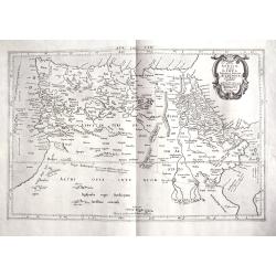
Argonautica.
A very nice map of Greece. Very decorative title cartouche centred in the upper part of the map. Three inset maps in upper left-hand corner and lower-right-hand corner, i...
Place & Date: Antwerp 1603-1618.
Selling price: $440
Sold
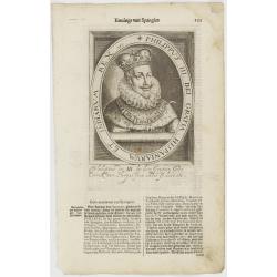
Philippus III. Dei Gratia Hispaniarum Et Indiarum Rex etc.
The engraving depicts a half length oval portrait of Philip III of Spain.Nicolaes de Clerck (de Klerc) was active as engraver and publisher in Delft from 1599-1621.Includ...
Place & Date: Amsterdam, Cloppenburch, 1621.
Selling price: $10
Sold

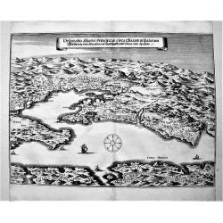
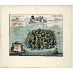
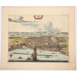
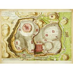
Valletta Citta Nova di Malta.
A fine, early map of Valletta, the capital of Malta. A very detailed view of the city with 41 locations of important buildings and locations. It includes a large inset ma...
Place & Date: Frankfurt am Mains, 1636
Selling price: $290
Sold in 2017
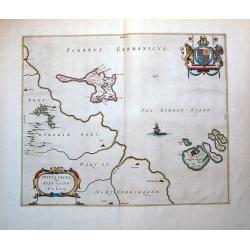
Insula Sacra; Vulgo Holy Iland; Et Farne.
Attractive map of Holy and Farne Islands off the coast of Northumberland. Farne Island is shown with the Tower and on Holy Island a fort and abbey are visible. The mainla...
Place & Date: Amsterdam, 1646.
Selling price: $180
Sold in 2012
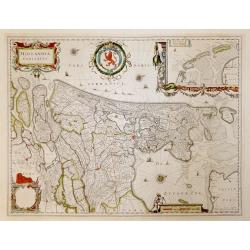
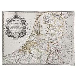
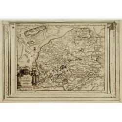
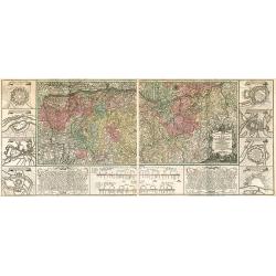
Hollandia Comitatus.
French text verso. Highly detailed regional map of Holland, showing the area around Amsterdam, Utrecht, Rotterdam, with an inset upper right corner of the Dutch Islands o...
Place & Date: Amsterdam, 1647
Selling price: $775
Sold in 2016
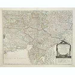
Delineatio Situsve Provinciae Clissam & spalatum. Abbildung oder Situation der Landschafft Clissa vnd Spalato.
An important copper engraving from Merian's Theatrum Europäum, 1652 (see Fauser Nr. 13238). It shows a bird's-eye view of the region of Split with the islands of Solta u...
Place & Date: Frankfurt a. M., 1654
Selling price: $120
Sold in 2019

Lisbona.
A rare panoramic view of Lisbon with over the whole length of the lower part 3 columns of poems in Latin, Dutch and French.Published by Dancker Danckerts (1634-1666)Colle...
Place & Date: Amsterdam, 1660.
Selling price: $1200
Sold

Helgolandia A o. 1649. / Helgoladt in annis Christi 800, 1300 & 1649. Johannnes Mejerus Husum.
Johan Blaeu succeeded his father Willem when the latter died in 1638. Johan led the Blaeu firm to its greatest achievement, the 'Atlas Maior' in 12 parts, the greatest an...
Place & Date: Amsterdam, 1662,
Selling price: $230
Sold

GEOGRAPHIAE SACRAE ex Veteri? TABULA PRIMA?
Map of the world according to the Sacred Geography, showing most of the Mediterranean and of the Middle East. Chanaan is shown before the conquest by the Jews. Inset: Isr...
Place & Date: Paris 1662.
Selling price: $250
Sold
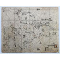
Pas-Caart vant Canaal Vertoonende in 't Gheheel Engelandt, Schotlandt, Yrlandt, en een Gedeelte van Vrancryck.
A fine chart of the British Isles. North is oriented to the right. Embellished with two compass roses, a galleon under sail and four national coats of arms. This chart ap...
Place & Date: Amsterdam, 1665-1666.
Selling price: $200
Sold in 2020

Ierusalem.
Engraved bird's eye plan, surrounded by biblical figures and objects, after N. Berchem. French text legends held by winged angels.From the large folio French Elzevier bib...
Place & Date: Leiden, 1669.
Selling price: $300
Sold

Sortie des Enfans d'Israel hors d'Egypte...
Map of the Holy Land. At the bottom, Moïse is depicted receiving the Tables of the Law on the Sinai Mount while on both sides are represented the scene of the escape out...
Place & Date: Leiden, 1669.
Selling price: $200
Sold
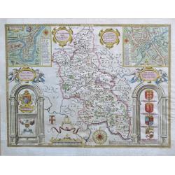
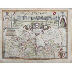
Buckinghamshire.
An attractive map of Buckinghamshire from the "Theatre of Great Britaine" by John Speed, published by Thomas Bassett and Richard Chiswell with two interesting i...
Place & Date: London, 1676
Selling price: $450
Sold in 2020

De Stadt Ierusalem zoot Hedendaeghs Bevonden wordt.
View of Modern Jerusalem. Legend along the bottom.From: Olfert Dapper Naukeurige beschryving van gantsch Syrie en Palestyn of Heilige Lant. Pt. II, p.327.Drawn after Bern...
Place & Date: Amsterdam 1677.
Selling price: $300
Sold

Ierusalem.
A panoramic view of the holy city of Jerusalem. With 52 descriptive points key in German and Latin.From: Dapper, Olfert Naukeurige beschryving van gantsch Syrie en Palest...
Place & Date: Amsterdam 1677.
Selling price: $350
Sold

Meta Phisicks.
Very attractive and decorative page about metaphysics. Decorated with symbols and figures. Published in "The Gentleman's Recreation" by Richard Blome.
Place & Date: London, ca. 1686
Selling price: $55
Sold in 2015
Perigrinatie ofte Veertich-jarige Reyse der Kinderen Israels.
Dutch so-called "Staten" bibles, published between 1637 and c. 1760, contained 5 maps: The World, "Paradise", The Perigrinations, The Promised Land Ca...
Place & Date: H. Keur en M. Doornik, Dordrecht-Amsterdam, 1686.
Selling price: $200
Sold
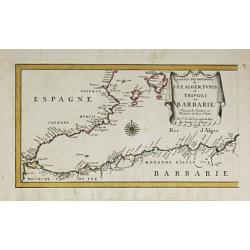
Les Costes des Royaumes de Fez, Alger, Tunis et Tripoli en Barbarie. 1677.
Piere du Val (1618-83), Paris-based cartographer and publisher. Atlases a.o. ' Cartes de Géographie', 1654-88, ' La Géographie universelle' , 1661-1712. After his death...
Place & Date: Paris, 1688.
Selling price: $190
Sold in 2014
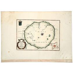
Isola di MARIA GALANTE neel Antilli. . .
A nice example of Coronelli's map of the island of Maria Galante, from his 'Isolario Dell'Atlante Veneto'. This is one of the few separate maps of the island of Marie-Gal...
Place & Date: Venice, ca 1690
Selling price: $100
Sold in 2020

Jerusalem.
Dutch so-called "Staten" bibles, published between 1637 and c. 1760, contained 5 maps: The World, "Paradise", The Perigrinations, The Promised Land Ca...
Place & Date: Amsterdam, 1690.
Selling price: $150
Sold
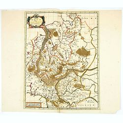
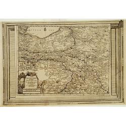
Marchia Nova Vulgo New Marck in March Brandenburg.
Hand-colored copper engraving by Moses Pitt and Stephan Swart. Published in Amsterdam, 1695.
Place & Date: Amsterdam, 1695.
Selling price: $20
Sold in 2020
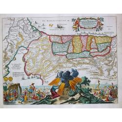
Tab. IV. Africae in qua Libya Interior et Exterior. Aethiopia sub Aegypto et Interior. . .
This finely engraved Ptolemaic map of Northern Africa shows the twin lake sources of the Nile located near the Lune Montes. The Niger River is prominently featured in Lib...
Place & Date: Utrecht, 1695?
Selling price: $130
Sold in 2018

Castra Suedica ad Fridirici Uddam.
From Pufendorf's famous chronicle on the Baltic area, ' Histoire du règne de Charles Gustave, roy de Suède'The Swedish fortifications in front of Fredericia, 1657.
Place & Date: Nürnberg, C. Riegel, 1697.
Selling price: $75
Sold in 2008

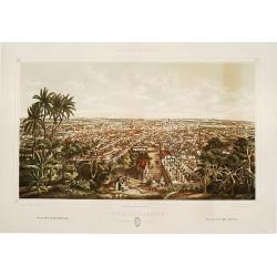
Matanzas: vista g'ral tomada desde el monte del Cafetal de..
Large colored lithograph from the series ,Isla de Cuba Pintoresca., Matanzas: vista g'ral tomada desde el monte del Cafetal de D. Vicente Guerrero. A large lithographed v...
Place & Date: Havana, Sergio Martin, [1856?].
Selling price: $2000
Sold
Puerto-Principe: vista g'ral tomada desde El Cristo.
Large colored lithograph from the series ,Isla de Cuba Pintoresca.A splendid, large lithographed view of the city of Puerto-Principe, (now Camag³ey) as seen from the eas...
Place & Date: Havana, Lith. del Gobierno, [1856?].
Selling price: $2000
Sold

Australien nach den neuesten astronomischen Bestimungen und Entdeckungs-Reisen. in Wienn bey Tranquillo Mollo.
Rare, early Map of Oceana and South East Asia. It is a great (early) depiction of an unfinished Australia with unfinished southern coast of the continent, also new Guinea...
Place & Date: Vienna, 1817-23
Selling price: $350
Sold in 2015
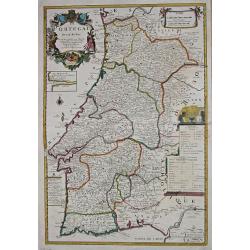
Le Portugal.
Le Père Placide de Sainte-Hélène was the brother-in-law of Pierre Duval. After the death of Duval his widow continued the firm.A large map of Portugal, with an inset o...
Place & Date: Paris, c. 1700.
Selling price: $275
Sold in 2013
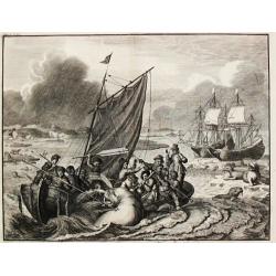
Tocht naer Nova Zemla in den Jaere MDXCVI.
A whaling scene from the voyage undertaken by the Dutch to Novoy Zemlya in the year 1596 under command of Willem Barentsz.
Place & Date: Amsterdam, c. 1700.
Selling price: $257
Sold

Graecia Antiquae Tabula Nova / Pars Meridionalis.
Guillaume de l' Isle (1675-1724), Royal Geographer, was the most influential cartographer of the first quarter of the 18th century. ' Atlas de Géographie' (1700-12), pos...
Place & Date: Paris, 1707.
Selling price: $360
Sold
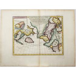
Carte Generale des Decouvertes de l'Amiral de Fonte, . . (Explorers)
An interesting map of the NW Coast of America and the NE Coast of Asia, based upon Jefferys map of 1768. Prior to Cook's 1st Voyage, the English, French and Russians were...
Place & Date: Paris, 1770ca
Selling price: $106
Sold in 2020
Saint Helena.
This fine hand colored original copper-plate engraved antique map of the Island of St Helena in the southern Atlantic that was published by Pieter Van der Aa. With cherub...
Place & Date: Leiden, ca 1710
Selling price: $130
Sold in 2020
BARKSHIRE DESCRIBED.
Original copperplate engraved map printed on handmade paper, with original hand coloring. A spectacular pictorial of WINDSOR CASTLE across the top of this decorative map....
Place & Date: London, 1710
Selling price: $400
Sold in 2013
![[Volckamer's Hespirides.]](/uploads/cache/83442-250x250.jpg)
[Volckamer's Hespirides.]
A copper engraving. Plate 220 from Volckamer's Nürnbergische Hesperides, a collection of citrus fruit. This plate depicts various blossoms in the top half of the engravi...
Place & Date: Nuremberg, 1708 [1714]
Selling price: $15
Sold in 2019
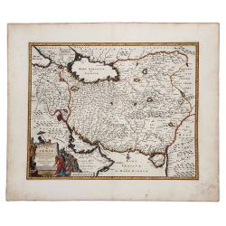
ROYAUME de PERSE avec les Pays Limitrophes et les Places maritimes, suivant les Relations des meilleurs Voyageurs nouvellement.
An attractive hand colored copper engraved map of the old Persian Empire, or modern-day Iran, published in 1719 in Leiden by Pieter van der Aa in the "Les Voyages du...
Place & Date: Leiden, ca 1719
Selling price: $65
Sold in 2019
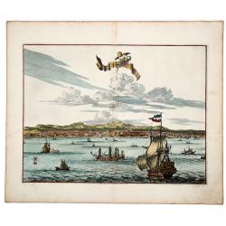
La Ville de l' AMBOINE, Capitale des Isles Molucques.
An attractive hand colored copperplate view of Ambon (Moluccas) by Pierre van der Aa. Shows the capital of Ambon Island with several ships in foreground during the the Du...
Place & Date: Leiden, ca 1719
Selling price: $100
Sold in 2019
Plan de la Ville de BANTAM, dans l'isle de Java.
An attractive hand colored copperplate view of Bantam by Pierre van der Aa. Shows the village with several ships in foreground during the the Dutch 'golden age' in Indone...
Place & Date: Leiden, ca 1719
Selling price: $150
Sold in 2019
La Hollande ou les Provinces Unies des Pays Bas.
A copperplate border colored map of Holland. A scarce map of the 7 Provinces as published in Paris by Danet. Includes 7 coats of arms in the title cartouche.
Place & Date: Paris, ca. 1720
Selling price: $400
Sold in 2019

Accurate Carte der Uplandischen Scheren mit der Situation und Gegend umb die Konigle Schwedisch Haupt und Residentz Stadt Stockholm.
A decorative map and a pair of views, focusing on Stockholm and its environs. The map shows Stockholm and the area around it, focusing on the approach from the sea. The ...
Place & Date: Nuremberg , ca 720
Selling price: $335
Sold in 2021
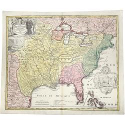
Amplissimae Regionis MISSISSIPI Seu Proninciae Ludovicianae.
A striking hand-colored example of Homann's map of the Course of the Mississippi River, based upon the reports of Hennepin, who explored the upper Mississippi and Great L...
Place & Date: Nuremberg, ca 1720
Selling price: $1000
Sold in 2019
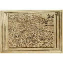
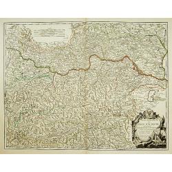
Cercle de Westphalie, suivant les nouvelles observations..
With decorative title cartouche upper left corner.This example is unusual in having the additional separately engraved decorative framework border around the map, the res...
Place & Date: Amsterdam 1728.
Selling price: $70
Sold
La Frise, suivant les nouvelles observations..
With decorative title cartouche lower left corner.This example is unusual in having the additional separately engraved decorative framework border around the map, the res...
Place & Date: Amsterdam 1728.
Selling price: $220
Sold
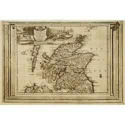
L'Ecosse, suivant les nouvelles observations..
With decorative title cartouche upper left corner.This example is unusual in having the additional separately engraved decorative framework border around the map, the res...
Place & Date: Amsterdam 1728.
Selling price: $270
Sold

Le Duché de Luxembourg, suivant les nouvelles observations..
With decorative title cartouche upper left corner.This example is unusual in having the additional separately engraved decorative framework border around the map, the res...
Place & Date: Amsterdam 1728.
Selling price: $240
Sold in 2009
La Zelande, suivant les nouvelles observations..
With decorative title cartouche upper left corner.This example is unusual in having the additional separately engraved decorative framework border around the map, the res...
Place & Date: Amsterdam 1728.
Selling price: $250
Sold
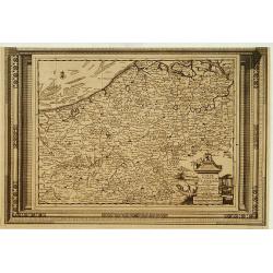
Carte du Comté de Flandre, suivant les nouvelles observations..
Including Belgium and Brabant. With decorative title cartouche lower right corner.This example is unusual in having the additional separately engraved decorative framewor...
Place & Date: Amsterdam 1728
Selling price: $120
Sold
La Gueldre, suivant les nouvelles observations..
With decorative title cartouche lower left corner.This example is unusual in having the additional separately engraved decorative framework border around the map, the res...
Place & Date: Amsterdam 1728.
Selling price: $102
Sold
Cercle de Bavière, suivant les nouvelles observations..
With decorative title cartouche upper right corner.This example is unusual in having the additional separately engraved decorative framework border around the map, the re...
Place & Date: Amsterdam 1728.
Selling price: $90
Sold
Description de l'ancienne Jerusalem selon Villalpand.
Richly detailed imaginary plan of ancient Jerusalem seen from the east. At bottom center of the plan itself, the Temple of Solomon is shown: upper left, the City of David...
Place & Date: [Paris ca. 1730]
Selling price: $180
Sold

A Map of the Children of Israel's Travels and Marches?
From Augustin Antoine Calmet, A historical, geographical?dictionary of the Holy Bible, London, 1732. Vol. I, between PP. 384-385.
Place & Date: [London 1732]
Selling price: $350
Sold
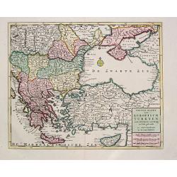
Nieuwe Kaart van Europisch Turkyen.
Izaak Tirion (d.1769) Amsterdam publisher. His Nieuwe en beknopte handatlas saw 6 editions between before 1740 and after 1784. Also Tegenwoordige staat van alle volkeren,...
Place & Date: Amsterdam, 1733.
Selling price: $225
Sold

Les Comtez de Hainaut, de Cambresis, et Partie du Comté de Namur..
Uncommon map showing southern Belgium provinces south of Brussels and published by Crepy.Including the towns of Lille, Brussels, Namen, Dinant, Cambray, Mons, etc.
Place & Date: Paris, 1735
Selling price: $300
Sold in 2015
![[RUSSIAN MAP] Battle of Stavuchany 1739.](/uploads/cache/85306-250x250.jpg)
[RUSSIAN MAP] Battle of Stavuchany 1739.
An extremely rare, large Russian single sheet map, of the plan of the battle of Stavuchany. Printed in Russian and German languages, possibly by the Academy of St.Petersb...
Place & Date: St.Petersburg, ca 1739
Selling price: $1500
Sold in 2021

The Honorable Robert Boyle.
Very decorative portrait copper engraving of Robert Boyle. It was engraved by the famous George Vertue from a painting by T. Kersseboom. Robert Boyle,(1627–1691) was a...
Place & Date: London, 1739
Selling price: $25
Sold in 2018
Charte Geographique de la Campagne du Haut Rhin...
Large map by J.F. Oettinger on 2 sheets.
Place & Date: Augsburg, 1740.
Selling price: $300
Sold in 2009

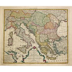
Imperii Turcici Europaei Tera in primis Graeciae.
Homann Heirs (of Johann Baptist and Johann Christof) published: Grosser Atlas, 1731, 1737. Geogr. Maior, 1759, Atlas Homannianus, 1762. A map showing the eastern Mediterr...
Place & Date: Nurnberg, 1741.
Selling price: $345
Sold
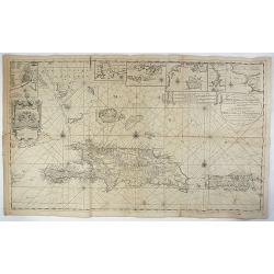
Nieuwe en Naaukeurige Paskaart van Het Eyland Hispaniola of St. Domingo met alle dresslss Havenen, Dieptens en Ankergronden, als meede de door passeeringe tusche de Caiques en andere Eylanden. naer de Opservatien van Monsr. Frezier. . .​
This rare magnificent large chart of Hispaniola and Puerto Rico was published by Johannes van Keulen II. The chart was compiled from the chart made by Amedee Francois Fre...
Place & Date: Amsterdam, ca. 1742
Selling price: $700
Sold in 2018

KAART van de LANDENGTE van PANAMA.
A detailed hand colored map of Panama, published in Amsterdam by Isaak Tirion. It depicts the City of Panama at the southeast, Chagres at the northwest and Porto-Bello at...
Place & Date: Amsterdam, ca 1745
Selling price: $150
Sold in 2019

Kaart van de Landengte van Panama.
Izaak Tirion (d. 1769) Amsterdam publisher. His ' Nieuwe en beknopte handatlas' saw 6 editions between before 1740 and after 1784. Also ' Tegenwoordige staat van alle vol...
Place & Date: Amsterdam, c. 1745.
Selling price: $120
Sold in 2015

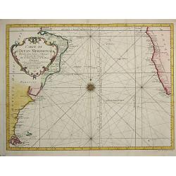
Carte de l' Ocean Occidental.
Jaques Nicolas Bellin (1702-720) was the most important French hydrographer of the 18th century. Sea-atlas 'Hydrographique Français' , 1756-65, atlas to accompany Prévo...
Place & Date: Paris, 1746.
Selling price: $250
Sold
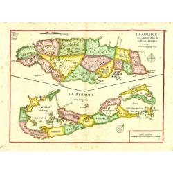
La Jamaique..Golfe du Mexique/ La Bermude.
"Two maps on one sheet; Jamaica and Bermuda. George Louis Le Rouge was active from 1740- till 1780 as a publisher, and was appointed engineer for the King of France....
Place & Date: Paris 1748.
Selling price: $250
Sold
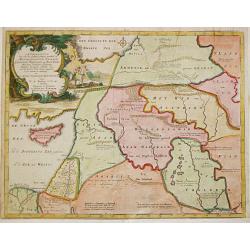
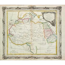
Afbeelding van all de Landen gelegen tusschen de Middellandsche, Zwarte, Caspische, Persische en Rode Zeën.
Willem Albert Bachiene (1712-1783), Dutch geographer in Maastricht. Most important work ' Heilige Geographie', a work on the Holy Land. Mathijs Schalenkamp published in 1...
Place & Date: Gorichem, Nicolaas Goetzee, 1748.
Selling price: $160
Sold

SICILIA ANTIQUA.
Attractive map of Sicily. Detailed with Rivers Mountains including Mt Etna erupting plus an inset map of Malta. From ‘Geographia Antiqua being a Complete Set of Maps of...
Place & Date: London 1750
Selling price: $50
Sold in 2017
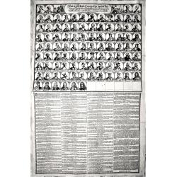
Neu verfertigte Conterfay sampt der Lebens-Beschreibung aller Könige in Spanien wie dieselbe einander ordentlich.. bis auf den jetzt Regierenden. (Karl III.)
Rare engraving depicting, in the upper part, all the kings of Spain till Carl III, in total it depicts 94 Kings.The lower part of the engravings describes each of them.Ra...
Place & Date: Germany, around 1750
Selling price: $150
Sold in 2018
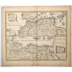
A New & Accurate Map of the Western parts of BARBARY, containing FEZ, MOROCCO, ALGIERS, TUNIS & BILEDULGERID.
An attractive and detailed map of North Africa by Emanuel Bowen (ca.1693-1767) an English engraver, publisher and map seller, active in London from about 1720. Map is enh...
Place & Date: London, ca 1750
Selling price: $31
Sold in 2019
Cercle de Souabe. . .
Finely and crisply engraved map of south part of Germany. Ornamental title cartouche in the upper part of map from his "Atlas Universel".Gilles Robert de Vaugon...
Place & Date: Paris, 1751.
Selling price: $20
Sold in 2015
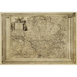
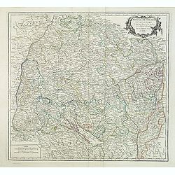
Partie Septentrionale du Cercle d'Autriche. . .
Detailed map of Austria, with an ornamental cartouche. Relief shown pictorially from his "Atlas Universel".Gilles Robert de Vaugondy (1688–1766), also known a...
Place & Date: Paris 1752.
Selling price: $60
Sold
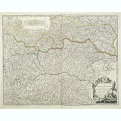
Partie Méridionale du Cercle d'Autriche. . .
Detailed map of Austria, with an ornamental cartouche. Relief shown pictorially from his "Atlas Universel".Gilles Robert de Vaugondy (1688–1766), also known a...
Place & Date: Paris 1752.
Selling price: $60
Sold in 2019
Partie Septentrionale du Cercle d'Autriche..
Detailed map of Austria, with an ornamental cartouche. Relief shown pictorially.
Place & Date: Paris 1752.
Selling price: $52
Sold
Partie Septentrionale du Cercle d'Autriche...
Map showing the postal routes in The Netherlands, Belgium, France, Poland, Austria, Switzerland and Northern Italy. With an ornamental cartouche.
Place & Date: Paris, 1752.
Selling price: $104
Sold
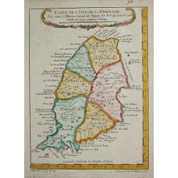
Carte de l' Isle de la Grenade.
Jaques Nicolas Bellin (1702-720) was the most important French hydrographer of the 18th century. Sea-atlas 'Hydrographique Français' , 1756-65, atlas to accompany Prévo...
Place & Date: Paris, c.1755.
Selling price: $70
Sold
Carte des Provinces de Tierra Firme, Darien, Cartagene et Nouvelle Grenade.
Jaques Nicolas Bellin (1702-720) was the most important French hydrographer of the 18th century. Sea-atlas 'Hydrographique Français' , 1756-65, atlas to accompany Prévo...
Place & Date: Paris, 1756.
Selling price: $130
Sold in 2008
Carte Particuliere de la Principaute de Halberstadt
Carte Particuliere de la Principaute de Halberstadt. A large and rare map of Halberstadt, Germany, and its surroundings by Le Rouge. Showing the town in the German state...
Place & Date: Paris, 17576
Selling price: $112
Sold in 2015
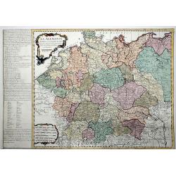
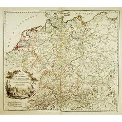
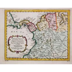
La ALEMANIA dividida en sus principales Estados segun las ultimas y nuevas observationes de las Accademias y de Paris y de Londres.
A beautiful, rare colored map of Germany by the Spanish cartographer Pedro Gendron. As in most 18th century maps published in Spain, which are based upon non-Spanish sour...
Place & Date: Madrid(?), ca 1760
Selling price: $150
Sold in 2020
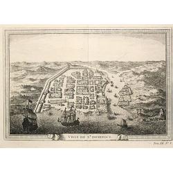
Ville de St. Domingue.
An attractive view of the town of St. Domingue.
Place & Date: Paris, c. 1760.
Selling price: $100
Sold
Carte de l Ocean Meridional, 1746.
Jaques Nicolas Bellin (1702-720) was the most important French hydrographer of the 18th century. Sea-atlas 'Hydrographique Français', 1756-65, atlas to accompany Prévos...
Place & Date: Amsterdam, c. 1760.
Selling price: $165
Sold

CARTE NOUVELLE D'AFRIQUE.
An original rare copper engraved map of 'modern' Africa by Moithey, published by Etienne André Philippe de Pretot, Paris, from the atlas 'Cosmographie Universelle' - ca ...
Place & Date: Paris ca 1765
Selling price: $180
Sold in 2021
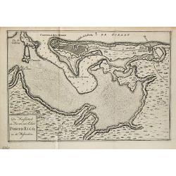
De Hoofdstad en Haven van 't Eiland Porto Rico in de Westindien.
Izaak Tirion (d. 1769) Amsterdam publisher. His 'Nieuwe en beknopte handatlas' saw 6 editions between before 1740 and after 1784. Also 'Tegenwoordige staat van alle volke...
Place & Date: Amsterdam, 1765.
Selling price: $145
Sold
Totius Danubii cum Adjacentibus Regnis nec non totius Graciae et Archipelagi.
Homann Heirs (of Johann Baptist and Johann Christof) published: Grosser Atlas, 1731, 1737. Geogr. Maior, 1759, Atlas Homannianus, 1762.A map depicting southeast Europe wi...
Place & Date: Nurnberg, 1766.
Selling price: $410
Sold
Partie de L' Afrique en deca de l' Equateur.
Louis Brion de la Tour (1756-1823), ' Atlas Géneral, Civil et Ecclésiastique', 1766, ' Atlas Général', 1790-98. Louis Charles Desnos (fl.1750-70), Le Rouge's 'Atlas N...
Place & Date: Paris, 1766.
Selling price: $150
Sold

Castellum Gibraltar in Andalusia..
Two maps of Gibraltar on one sheet: a plan of the Rock up to the Spanish lines: and a chart of the Straits, also showing Cadiz and Marbella. The title cartouche shows the...
Place & Date: Augsburg, c.1770.
Selling price: $250
Sold in 2021