Browse Listings
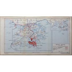
Hong Kong
A detailed interesting map in full original lithographic color. The map shows Hong Kong (In red) with Lantau Island and the tip of China an inset map shows Hong Kong’s ...
Place & Date: London, 1948
Selling price: $80
Sold in 2016
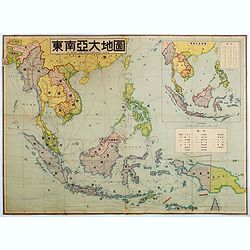
A map of southeast Asia.
Large color-printed map of South East Asia and centered on Philippines and Singapore. With inset map in the upper right corner. Showing railroad systems, maritime steambo...
Place & Date: China, ca. 1948
Selling price: $1150
Sold in 2016
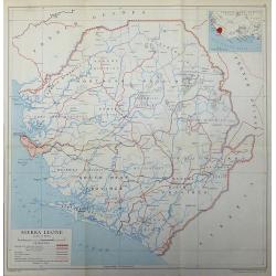
Sierra Leone
A 1948 map of Sierra Leone published by the Directorate of Colonial Surveys, and printed by the War Office.
Place & Date: London, 1948
Selling price: $45
Sold in 2017

Nyasaland Protectorate
Nyasaland Protectorate published by the Directorate of Colonial Surveys, and printed by the War Office in 1948.
Place & Date: London, 1948
Selling price: $45
Sold in 2017
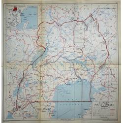
Uganda Protectorate
A 1948 map of Uganda under the British Protectorate, published by the Directorate of Colonial Surveys, and printed by the War Office.
Place & Date: London, 1948
Selling price: $45
Sold in 2017
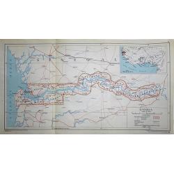
Gambia
A 1948 map of Gambia under the British Protectorate, published by the Directorate of Colonial Surveys, and printed by the War Office.
Place & Date: London, 1948
Selling price: $45
Sold in 2017

Kenya Colony
A 1948 map of the Kenya Colony, published by the Directorate of Colonial Surveys, printed by the War Office.
Place & Date: London, 1948
Selling price: $45
Sold in 2017

Northern Rhodesia
A 1948 map Northern Rhodesia published by the Directorate of Colonial Surveys, printed by the War Office.
Place & Date: London, 1948
Selling price: $45
Sold in 2017
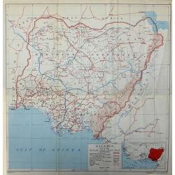
Nigeria
A 1948 map of Nigeria published by the Directorate of Colonial Surveys, printed by the War Office.
Place & Date: London, 1948
Selling price: $45
Sold in 2017
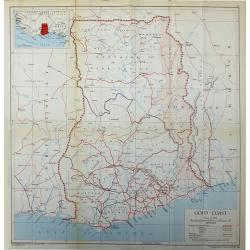
Gold Coast
The African Gold Coast published by the Directorate of Colonial Surveys, and printed by the War Office in 1948.
Place & Date: London, 1948
Selling price: $45
Sold in 2017
![[Post card] The United states as seen through the eyes of Texas.](/uploads/cache/40291-250x250.jpg)
[Post card] The United states as seen through the eyes of Texas.
Pictorial post card map of North America with the state of Texas taking up the entire middle portion of the map, and a large red heart in the middle reads "Biggest a...
Place & Date: Chicago, 1948
Selling price: $25
Sold in 2017

Nouvelle Angleterre - New York.
An interesting chromolithograph map of New York. Text and corresponding map with lavish vignettes of historic events, activities, crops, modes of transportation, structur...
Place & Date: Paris, 1948
Selling price: $27
Sold in 2018
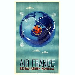
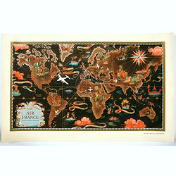
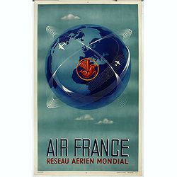
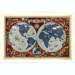
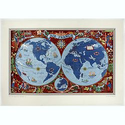
AIR FRANCE Réseau aérien mondial.
A great mid century design by Air France advertising poster by Plaquet. The flying sea horse was the logo of the company until 1975. This is the french version The poste...
Place & Date: Imprimerie Perceval Paris, ca. 1948
Selling price: $1050
Sold in 2019
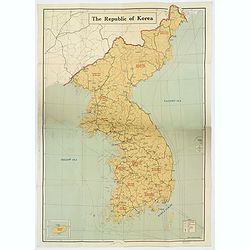
The Republic of Korea.
A large, folding map of The Republic of Korea, published before the country split into two (1950) with the "Democratic People's Republic of Korea" (North Korea)...
Place & Date: Seoul, ca 1948
Selling price: $525
Sold in 2020
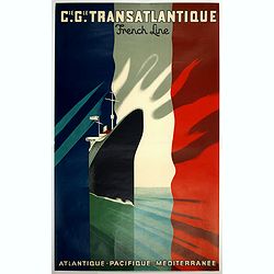
Cie GLE Transatlantic French Line. Atlantique, Pacific, Méditerranée.
color lithographed poster by the French artist Paul Colin printed by Imprimerie Courbet, Rue de Charonne, Paris - Editions "Transatlantique. Depicting a boldly appro...
Place & Date: Paris, ca. 1948
Selling price: $360
Sold in 2019

Greater Portland, Maine.
Pictorial map of Portland, Maine, with decorative title cartouche and 6 views of landmarks at the margins. Design by Edwin Otis Nielsen Shows cities, landmarks, recreatio...
Place & Date: Portland, 1948
Selling price: $425
Sold in 2019

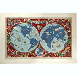
AIR France - Réseau Aérien Mondial.
"Réseau Aérien Mondial" original pictorial color lithographed advertising planisphere poster from AIR France. The poster has a black back ground. In the lower...
Place & Date: Imprimerie Perceval, Paris, ca. 1948
Selling price: $1490
Sold in 2023

L'Union Française - Les Etats Associés d'Indochine.
Original chromo lithographed poster showing Laos, Vietnam, Cambodia and Indochina, published ca. 1948 for "Les Etats Associés d'Indochine Affaire ".Pictorial p...
Place & Date: Paris, 1948
Selling price: $3680
Sold in 2020
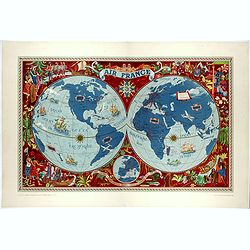
AIR France - Réseau Aérien Mondial.
"Réseau Aérien Mondial" original pictorial lithograph advertising planisphere poster from AIR France. The poster has a black back ground. In the lower right b...
Place & Date: Paris, ca. 1948
Selling price: $675
Sold in 2020

The Mapmaker.
Satirical condemnation of the Axis leaders by a Polish-Jewish cartoonist.Issued in a 1942 edition of Esquire Magazine, this image by the talented artist Arthur Szyk shows...
Place & Date: London, 1948
Selling price: $175
Sold in 2021

Oxford.
A comprehensive pictorial overview of Oxford’s rich history, especially in education.This image of Oxford is one of several pictorial maps Kerry Lee created to promote ...
Place & Date: London, 1948
Selling price: $425
Sold in 2022
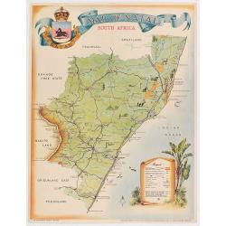
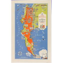
Map of Natal.
Pictorial map of Natal showing the rail way system, published by the Government printer. Decorated with tourist attractions and key in lower right.Read more about Pictori...
Place & Date: Pretoria, 1949
Selling price: $70
Sold in 2020
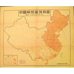
Map of the Liberated Regions in China.
Fine sample of a map with a political character. Rare map depicting areas held by the Communists during the Chinese Revolution up to 1st July, 1949.More about cartographi...
Place & Date: Beijing, 1949
Selling price: $120
Sold in 2012
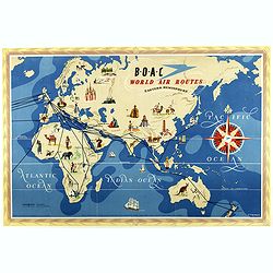
World Air Routes: Eastern Hemisphere / B.O.A.C. - World Air Routes: Western Hemisphere.
Original Vintage pictorial map of the Eastern Hemisphere issued by B.O.A.C. Artwork by E.O.Seymour. On the verso, the western hemisphere.The map was issued as a folding m...
Place & Date: Great Britain, 1949
Selling price: $210
Sold in 2018
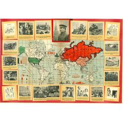
Bold World Map for the 70th anniversary of Joszif Visszarionovics STALIN.
Extremely rare, separately, only once issued, so called "placard / poster" economical world map! Surrounded by the portrait of "the big and genius leader ...
Place & Date: Budapest, 1949
Selling price: $750
Sold in 2019
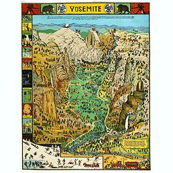
Yosemite
A colorful map of Yosemite Valley drawn by artist Jo Mora in 1931 and re-issued in color in 1941. The map shows many humorous scenes and shows the activities common at th...
Place & Date: Yosemite, Curry Company, 1941/1949
Selling price: $141
Sold in 2019
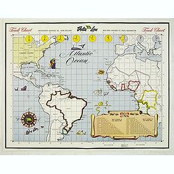
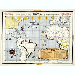
Track Chart
Map of the Atlantic Ocean, used as a hand out to the passangers to keep daily track.
Place & Date: New Orleans, c. 1950
Selling price: $65
Sold in 2015
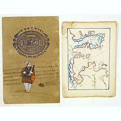
Manuscript map of Aegean Sea centered on Izmir.
Manuscript map of Aegean Sea centered on Izmir. The map possibly made arround 1950. Decorative. Together with a recent drawing of a Indian musician on a brownish paper wi...
Place & Date: Turkey, 1780/1950
Selling price: $35
Sold in 2014

A Pictorial Map of Cyprus.
An attractive hand painted map of Cyprus a scroll cartouche has the Historical dates of the Islands occupation, the map centers on Nicosia. The sea has galleons, sea mons...
Place & Date: ca. 1950
Selling price: $95
Sold in 2014
Track Chart.
Map of the Atlantic Ocean, used as a hand out to the passengers to keep daily track.Read more Pictorial Maps [+]
Place & Date: New Orleans, c. 1950
Selling price: $2
Sold in 2017

Kyoto and Vicinity with Shopping District.
An attractive colored plan of the Japanese city of Kyoto, with smaller insets of a plan of Maruyama Park, a map of Kyoto and Vicinity, and a plan of Momoyama. Complete wi...
Place & Date: Kyoto, ca. 1950
Selling price: $40
Sold in 2018
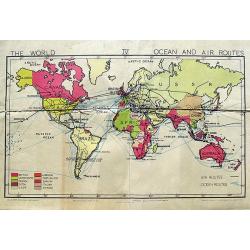
The World Ocean and Air Routes.
An interesting school map of the World illustrating the air and sea routes. The coloring shows the colonial powers. From Gill's Simplified Wall Map Series.
Place & Date: London, ca. 1950
Selling price: $28
Sold in 2018
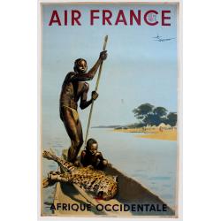
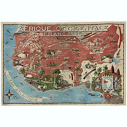
Afrique occidentale.
A poster for Air France of West Africa, designed by A. Brenet in 1952. Albert Brenet (1903-2005) was a French painter, poster artist and illustrator.More about "Post...
Place & Date: Paris, ca 1950
Selling price: $700
Sold in 2020
![Suid-Afrikaanse Lugdiens Roetekaart dui binnenlandse dienste en die Springbokdiens-route... [with on verso] South African Airways Route Map Shewing Internal Services and Springbox ...](/uploads/cache/82045-250x250.jpg)
Suid-Afrikaanse Lugdiens Roetekaart dui binnenlandse dienste en die Springbokdiens-route... [with on verso] South African Airways Route Map Shewing Internal Services and Springbox ...
Suid-Afrikaanse Lugdiens Roetekaart dui binnenlandse dienste en die Springbokdiens-route... [with on verso] South African Airways Route Map Shewing Internal Services and ...
Place & Date: Johannesburg, 1950
Selling price: $50
Sold in 2018
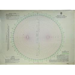
Modified Weir Azimuth Diagram.
British Admiralty Astronomical Chart 5001: Azimuth diagram - modified Weir.
Place & Date: London, 1950
Selling price: $50
Sold in 2019

Al sole d'Italia... La frutta migliore... Adani Massalombarda Bologna. (From the sun in Italy comes the best fruit.)
Vintage advertising poster by the famous artist Luigi (Gino) Boccasile (Bari, 14 july 1901 – Milan, 10 Mai 1952 ) for an Italian brand of alcohol. Depicts a woman with ...
Place & Date: Milan. ca. 1950
Selling price: $90
Sold in 2021
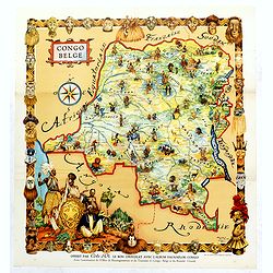
Congo Belge.
This poster was included in the picture book "Faunaflor-Kongo" of the chocolate manufacturer Côte D'or. Printed in Belgium by Ets. Leon Beyaert-Sioen N.V. Kort...
Place & Date: Kortrijk, ca. Ca. 1950
Selling price: $35
Sold in 2019

Mount Abu - Visit India.
Lithographed poster showing Mount Abu and Nakki Lake, a touristic hill station in western India’s Rajasthan state, near the Gujarat border. Nakki Lake is a popular spot...
Place & Date: India, Madras, ca. 1950
Selling price: $500
Sold in 2019
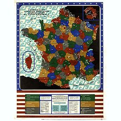
Principales activités françaises bénéficiaires du plan Marshall.
Marshall Plan poster published by the services of the mission specializing in France the E.C.A. colored map of the regions of France where the economic activities benefit...
Place & Date: Kühn & Zoon Rotterdam, 1950
Selling price: $100
Sold in 2019
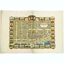
Buenos Aires Capital de La Republica Argentina. Una Nacion Socialmente Justa Economicamente Libre. . .
A beautiful pictorial town plan of the Argentinian Capital Buenos Aires, as published in 1950. The downtown area of side streets and attractive wide avenues are covered w...
Place & Date: Buenos Aires, ca 1950
Selling price: $850
Sold in 2019
Afrique Occidentale Française AOF.
Beautiful and decorative lithograph pictorial map of French West Africa, showing tribes, animals, monuments, landscapes. Made for Ministere de la France d'Outre-mer, agen...
Place & Date: Imprimerie Jombart, Asnières, ca. 1950
Selling price: $1000
Sold in 2020
Réseau aérien mondial.
"Sur les ailes d'Air France, découvrez le monde à votre tour" advertising lithograph poster from AIR France, the French airline company. The poster has always...
Place & Date: Imprimerie Perceval Paris, ca. 1940-1950
Selling price: $1750
Sold
Planisphéres terrestes. Quelques voyages récents de batiments de guerre.
Stunning world map by Hervé Baille published in Paris in 1950 at G. Barbarin & Cie. The map focuses on the routes and travel of explorer like La Perouse, Beautemps-B...
Place & Date: G. Barbarin & Cie, Paris, 1950
Selling price: $750
Sold in 2020

Ville Saigon edité par Havas Extréme Orient.
Decorative publicity plan of Ho Chi Minh City, also known by its former name of Saigon, Vietnam, surrounded by advertisements of local stores. In the center the "Jar...
Place & Date: Paris, 1950
Selling price: $1200
Sold in 2019
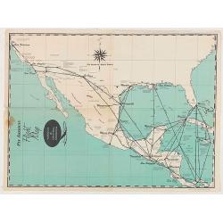
Pan American Flight Map - Mexico & Central America.
Pan American Airlines Flight Map of Mexico & Central America from the mid 1950's.
Place & Date: United States, ca 1950
Selling price: $60
Sold in 2020
Pan American Flight Map - Mexico & Central America.
Pan American Airlines Flight Map of Mexico & Central America from the mid 1950's.
Place & Date: United States, ca 1950
Selling price: $50
Sold in 2020
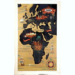
DOHET, C.
Chromo-lithographed poster designed by the artist Claude Dohet for the Belgium airline company Sabena, showing a map of Africa, Europe and part of Asia. The routes are hi...
Place & Date: Brussels, Lismo, 1950
Selling price: $950
Sold in 2021

Guerre d'Indochine le Tonkin.
Pictorial map of Tonkin drawn by R. Forgues. on the verso information's about Indochina.More about Pictorial Maps [+]
Place & Date: France, ca. 1950
Selling price: $120
Sold in 2020
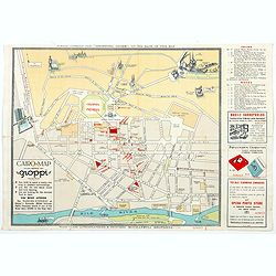
Souvenir Guide Map of Cairo.
A lovely small colored plan of central Cairo, published by Groppi in Cairo. The plan clearly lays out the streets and important buildings and places of interest nearest t...
Place & Date: Cairo, 1920-1950
Selling price: $14
Sold in 2020
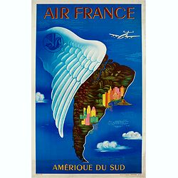
Air France Amérique du Sud.
Very decorative lithographed advertising poster of South America, for Air France, by Lucien Boucher. The poster has always occupied a special place in Air France's commun...
Place & Date: Imprimerie Perceval, Paris, 1950
Selling price: $1200
Sold in 2020

Carte Archeologique D'Angkor.
colorful tourist map centered on Angkor Vat, including its surroundings.
Place & Date: ca. 1950
Selling price: $120
Sold in 2020
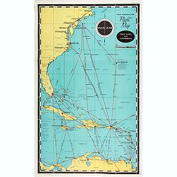
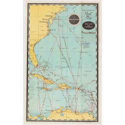
Pan American Airways New York - Caribbean.
Pan American Airlines Flight Map of New York to Caribbean from the mid 1950's.
Place & Date: United States, ca. 1950
Selling price: $50
Sold in 2021
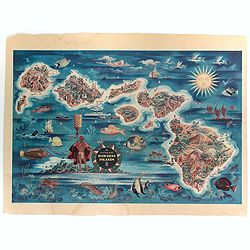
The Dole Map of the Hawaiian Islands.
A terrific, colorful poster of the Hawaiian Islands by Joseph Feher, commissioned for the Hawaiian Pineaple Co. The poster displays all eight of the major islands in the ...
Place & Date: USA, 1950
Selling price: $100
Sold in 2022
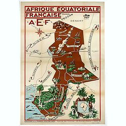
Afrique Equatoriale Française AEF.
Beautiful and decorative lithograph pictorial map of Equatorial Africa, showing tribes, animals, landscapes… Made for Ministere de la France d'Outre-mer, agence des Col...
Place & Date: Imprimerie Jombart, Asnières, ca. 1951
Selling price: $950
Sold in 2020
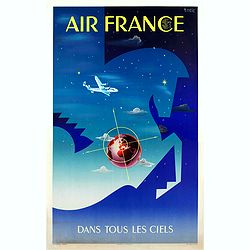
Air France dans tous les ciels.
Original lithograph advertising poster for Air France, by Badia Vilato Xavier. Signed in the upper right corner. The poster has always occupied a special place in Air Fra...
Place & Date: Imprimerie Perceval, Paris, 1951
Selling price: $2000
Sold in 2020
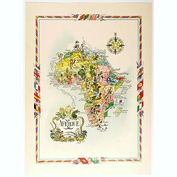
Afrique.
color printed pictorial map of Africa, with decorative title cartouche and borders, depict countries, regions, major cities, animals and wildlife. Includes decorative com...
Place & Date: Paris, 1951
Selling price: $50
Sold in 2020
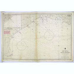
Gulf of Mexico. Ship Shoal to Brazos Santiago.
A large sea chart of the Gulf of Mexico, Ship Shoal to Brazos Santiago, 'from Admiralty Charts and US Government charts, corrected to 1943'. (In fact there are correction...
Place & Date: London, 1951
Selling price: $100
Sold in 2017

The Union Pacific West / Western Wonderlands.
A striking folded pictorial map of The western states of America, from Nebraska and Kansas to the Pacific coast. Inset of the region covered in context of general map of ...
Place & Date: United States, 1951
Selling price: $50
Sold in 2018
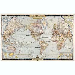
The World Map.
World map centered on North America, with inset maps of North and South Poles. The first issue of National Geographic Magazine was published on September 22, 1888, nine m...
Place & Date: Washington, 1951
Selling price: $3
Sold in 2023
Amérique du Nord et Centrale.
color printed pictorial map of North and Central America, with decorative title cartouche and borders, depict countries, regions, major cities, industries, agriculture, I...
Place & Date: Paris, 1951
Selling price: $110
Sold in 2018

Afrique.
color printed pictorial map of Africa, with decorative title cartouche and borders, depict countries, regions, major cities, animals and wildlife. Includes decorative com...
Place & Date: Paris, 1951
Selling price: $110
Sold in 2018
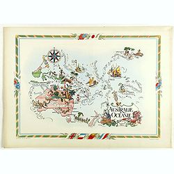
Australie et Océanie.
color printed pictorial map of Australia and Oceania, with decorative title cartouche and borders, depict countries, regions, major cities, industries, agriculture and wi...
Place & Date: Paris, 1951
Selling price: $130
Sold in 2018
![[World Map].](/uploads/cache/42059-250x250.jpg)
[World Map].
color printed pictorial world map, with decorative title cartouche and borders, depict continents, mores and wildlife. Includes decorative compass rose. Published by Ode ...
Place & Date: Paris, 1951
Selling price: $110
Sold in 2018
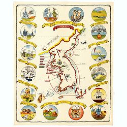
(Map of Korea) 1950 Portsmouth 1952 H.M. Ceylon.
A fine folding pamphlet produced for the H.M.S. Ceylon, a British Navy Ship, taking part in the "Operation War Dance, when patrolling Korea in 1952 during the Korean...
Place & Date: Hong Kong, The local printing press, Ltd., 1952
Selling price: $250
Sold in 2014
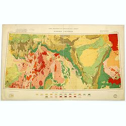
Carte géologique du Nord-Ouest del'Afrique SAHARA CENTRAL.
Geological map showing the Sahara and made by M.Lelubre, R.Karpoff, J.Follot, P.Bordet, A.Cornet, M.Dalloni, etc. Printed by Dufrenoy of Paris.Published by "Comité ...
Place & Date: Paris, c. 1952
Selling price: $160
Sold in 2017
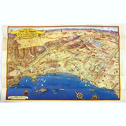
Ride the Roads to Romance along the Golden Coast...
A fun, large folding touring map of the Golden Coast and through the Sunshine Empire of southern California. From just north of Malibu Beach down past San Diego to Ensena...
Place & Date: California, 1952
Selling price: $160
Sold in 2016
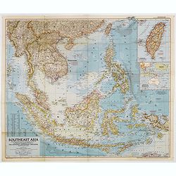
Southeast Asia Compiled and Drawn in the Cartographic Section of the National Geographic Society for the National Geographic Magazin Gilbert Grosvenor. . .
Map of the Southeast Asia, with inset map of Taiwan an map with Australia. The first issue of National Geographic Magazine was published on September 22, 1888, nine month...
Place & Date: Washington, 1952
Selling price: $50
Sold in 2018
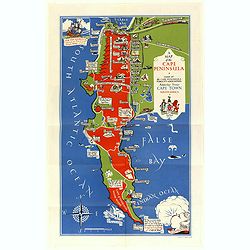
A Map of the Cape Peninsula. Issued by the Cape Peninsula Publicity Association Adderley Street Cape Town South Africa.
Beautiful pictorial map of the Cape Peninsula South Africa shows, its neighbourhood's, green spaces, and historic points of interest. Drawn by Stuart Boyle and published ...
Place & Date: Cape Town, 1952
Selling price: $325
Sold in 2018
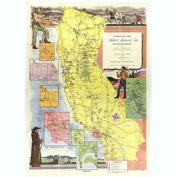
A Map of the Marked Historical Sites of California.
A large, colorful and impressive map of the American state of California, showing the historical sites of the state. There are 496 numbered sites depicted on the map.In a...
Place & Date: California, 1952
Selling price: $140
Sold in 2018
AIR France - Sur les ailes d'Air France découvrez le monde à votre tour.
Promotional poster of a double hemisphere world map designed by Lucien Boucher for AIR France. The map depicts the entire world in rich blues and burgundies with gold hig...
Place & Date: Perceval, Paris, 1952
Selling price: $1200
Sold in 2019
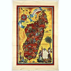
Madagascar.
Spectacular promotional travel poster of Madagascar, design by Maurice Tranchant in 1952 and printed by G. Raidot in Paris. In lower right a cartouche giving general info...
Place & Date: Paris, 1952
Selling price: $400
Sold in 2019
Air France - Sur les ailes d'Air France découvrez le monde à votre tour.
Promotional poster of a double hemisphere world map designed by Lucien Boucher for AIR France. The map depicts the entire world in rich blues and burgundies with gold hig...
Place & Date: Perceval, Paris, 1952
Selling price: $2200
Sold in 2020
A Map of the Cape Peninsula. Issued by the Cape Peninsula Publicity Association Adderley Street Cape Town South Africa.
Beautiful pictorial map of the Cape Peninsula South Africa shows, its neighborhood's, green spaces, and historic points of interest. Drawn by Stuart Boyle and published b...
Place & Date: Cape Town, 1952
Selling price: $80
Sold in 2020
AIR France - Sur les ailes d'Air France découvrez le monde à votre tour.
Promotional poster of a double hemisphere world map designed by Lucien Boucher for AIR France. The map depicts the entire world in rich blues and burgundies with gold hig...
Place & Date: Perceval, Paris, 1952
Selling price: $1900
Sold in 2020
AIR France - Sur les ailes d'Air France découvrez le monde à votre tour.
Promotional poster of a double hemisphere world map designed by Lucien Boucher for AIR France. The map depicts the entire world in rich blues and burgundies with gold hig...
Place & Date: Perceval, Paris, 1952
Selling price: $2175
Sold in 2023

A Map of Downtown Chicago.
Silk map of Chicago’s Loop issued to celebrate the 100th anniversary of Marshall Field & Company.Though it nominally functions as a map of Chicago’s downtown, the...
Place & Date: United-states, 1952
Selling price: $200
Sold in 2021

Decorative Printed Maps from the 15th - 18th Centuries.
From the Superintendent of the Map Room, British Museum, and a leading expert in antique maps. This illustrated book provides a survey of maps printed from copper plates ...
Place & Date: London: Staples Press, 1952
Selling price: $50
Sold in 2013
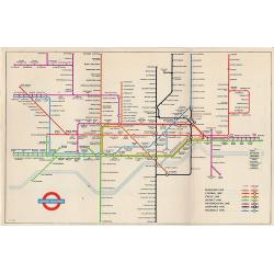
1953 Harry Beck London Underground map.
Published in the Queen's coronation year. A London Underground map (double sided).
Place & Date: London, 1953
Selling price: $60
Sold in 2019
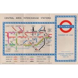
1953 Harry Beck London Underground map.
1953 - The Queen's coronation year. London Underground map (double sided).
Place & Date: London, 1953
Selling price: $50
Sold in 2017
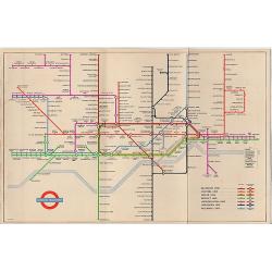
(1953 Harry Beck London Underground map.)
1953 - The Queen's coronation year. London Underground map (double sided) .
Place & Date: London, 1953
Selling price: $65
Sold in 2017
![CH'ONHA CHIDO [Atlas of all under Heaven]](/uploads/cache/33625-250x250.jpg)