Browse Listings

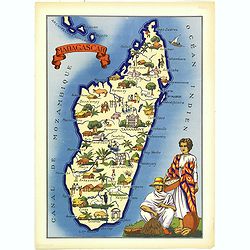
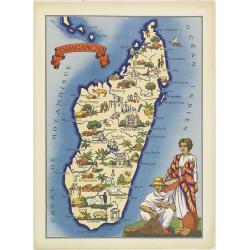
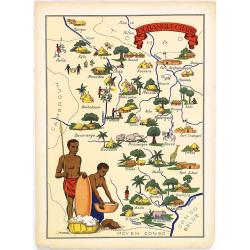
Madagascar
Very decorative, informative map of Madagascar. The map is filled with buildings, animals, figures and two locals in their typical dress.In lower left corner "Imprim...
Place & Date: France, 1943
Selling price: $60
Sold in 2016
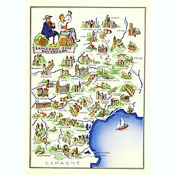
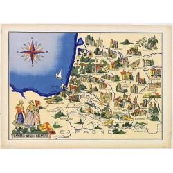
Languedoc - Foix Roussillon.
Very decorative, informative map of Languedoc - Foix Roussillon region in south eastern France. Including the towns of Carcassonne, Montpellier,, Albi, Toulouse, etc.The ...
Place & Date: France, 1943
Selling price: $95
Sold in 2016

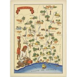
Niger.
Very decorative, informative map of Nigeria. The map is filled with buildings, animals, figures and two locals. With a large compass rose in upper right corner.In lower l...
Place & Date: France, 1943
Selling price: $60
Sold in 2016
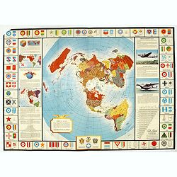
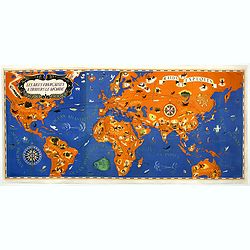
Global Map for Global War and Global Peace.
Map border has aircraft insignia for nations of the world, a table of air lines distances (worldwide), illustrations of the "flying boat" and a bomber, and map ...
Place & Date: New York, 1943
Selling price: $75
Sold in 2016

New Zealand. Her Natural and Industrial Recources.
Decorative Pictorial Map of New Zealand, by the celebrated illustrator Gill (Leslie) MacDonald Gill (1884 - died 1947) who produced for the British Ministry of Informatio...
Place & Date: London, Alf Cooke Ltd, 1943
Selling price: $1200
Sold
![America's Worldwide War [with] American troops. . .](/uploads/cache/39803-250x250.jpg)
America's Worldwide War [with] American troops. . .
Two World maps centered on the Americas. The top map with a text underneath : America's Worldwide War is illustrated by this map based on the Marshall report ... The lowe...
Place & Date: New York , Time Magazine, 1943
Selling price: $525
Sold in 2017
Madagascar.
Very decorative, informative map of Madagascar. The map is filled with buildings, animals, figures and two locals in their typical dress.In lower left corner "Imprim...
Place & Date: France, 1943
Selling price: $60
Sold in 2018
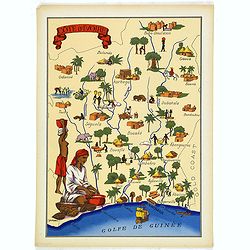
Cote d'Ivoire
Very decorative, informative map of the Ivory coast. The map is filled with buildings, animals, a ship, figures and two locals in their typical dress.In lower left corner...
Place & Date: France, 1943
Selling price: $60
Sold in 2018
Les Ailes Française à travers le Monde - Raids et exploits.
Very large pictorial world map signed "Troy 43" and created for "The Air Minister". The French Air Ministry was created by decree in 1928. The prime m...
Place & Date: Paris, 1943
Selling price: $1850
Sold in 2019
Madagascar
Very decorative, informative map of Madagascar. The map is filled with buildings, animals, figures and two locals in their typical dress.In lower left corner "Imprim...
Place & Date: France, 1943

LAOS Région Nord.
Very decorative, informative map of the northern region of Laos. With a compass rose in upper left corner, the map is filled with buildings, animals, figures and two loca...
Place & Date: France, 1943
Selling price: $152
Sold in 2010

LAOS ANNAN Région Sud.
Very decorative, informative map of the region of Laos and Annan. The map is filled with buildings, animals, figures and two locals in their typical dress.In lower left c...
Place & Date: France, 1943
Selling price: $160
Sold in 2010
Cote d'Ivoire
Very decorative, informative map of the Ivory coast. The map is filled with buildings, animals, a ship, figures and two locals in their typical dress.In lower left corner...
Place & Date: France, 1943
Selling price: $90
Sold in 2012
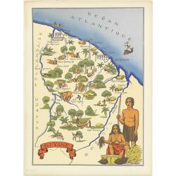
Guyane.
Very decorative, informative map of French Guyne. The map is filled with buildings, animals, figures and two locals in their typical dress.In lower left corner "Impr...
Place & Date: France, 1943
Selling price: $90
Sold in 2014
Oubangui-Chari.
Very decorative, informative map of Central Africa. The map is filled with buildings, animals, figures and two locals in their typical dress.In lower left corner "Im...
Place & Date: France, 1943
Selling price: $90
Sold in 2018
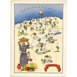
Alger.
Very decorative, informative map of Algeria. The map is filled with buildings, animals, figures and two locals in their typical dress.In lower left corner "Imprimé ...
Place & Date: France, 1943
Selling price: $90
Sold in 2018

Oran. (Algeria)
Very decorative, informative map of Oran province in Algeria. The map is filled with buildings, animals, ships, figures and two locals in their typical dress.In lower lef...
Place & Date: France, 1943
Selling price: $70
Sold

Maroc.
Very decorative, informative map of Marocco. The map is filled with buildings, animals, a ship, figures and three locals in their typical dress.In lower left corner "...
Place & Date: France, 1943
Selling price: $60
Sold in 2010
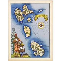
La Guadeloupe La Martinique.
Very decorative, informative map the French islands of Guadeloupe and Martinique among others. The map is filled with buildings, animals, a ship, figures and three locals...
Place & Date: France, 1943
Selling price: $90
Sold in 2010

St. Pierre et Miquelon.
Very decorative, informative map of St. Pierre et Miquelon. The map is filled with buildings, animals, ships and boats, figures, and a local in the typical dress.In the l...
Place & Date: France, 1943
Selling price: $60
Sold in 2011
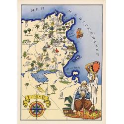
Tunisie.
Very decorative, informative map of Tunesia. The map is filled with buildings, animals, a ship, figures and two locals in their typical dress. With a large compass rose i...
Place & Date: France, 1943
Selling price: $90
Sold in 2018
Basque - Bearn - Bigorre.
Very decorative, informative map of Basque - Bearn - Bigorre in south western France. Including the towns of Biarritz, Dax, Bayonne, Lourdes, etc. The map is filled with ...
Place & Date: France, 1943
Selling price: $90
Sold in 2013

Niger.
Very decorative, informative map of Nigeria. The map is filled with buildings, animals, figures and two locals. With a large compass rose in upper right corner.In lower l...
Place & Date: France, 1943
Selling price: $90
Sold in 2018
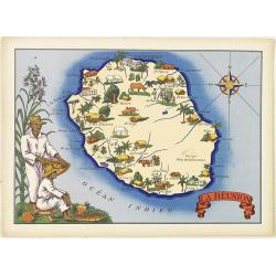
La Réunion.
Very decorative, informative map of the island of Reunion. The map is filled with buildings, animals, figures and two locals. With a large compass rose in upper right cor...
Place & Date: France, 1943
Selling price: $70
Sold
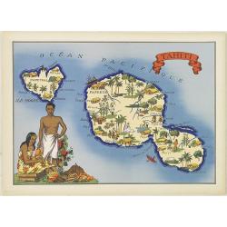
Tahiti.
Very decorative, informative map of Tahiti. The map is filled with buildings, animals, figures and two locals. With a large compass rose in upper right corner.In lower le...
Place & Date: France, 1943
Selling price: $90
Sold in 2015
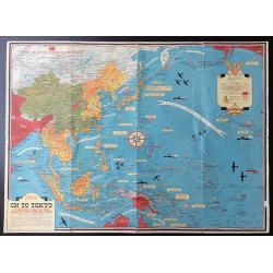
Dated Events. On To Tokyo. Map of the Pacific and the Far East + War In Europe.
Double sided map. Eighth edition. On one side shows the latest activity in the Pacific Arena. Note below title: "With this invasion map you will be able to follow th...
Place & Date: Toronto, 1944
Selling price: $180
Sold in 2020

Ryukyo-Retto Photo maps 1:10,000 Secret. First edition. (Six maps)
A group of six printed maps for the US army of photos made in September 1944 of Nakagami-gun (country) including Okinawa. Kin m (Sheet 3626-II m), Yonaburu b (sheet 3625-...
Place & Date: Washington, September 1944
Selling price: $5
Sold in 2014

Ryukyo-Retto Photo maps 1:10,000 Secret. First edition. (Six maps)
A group of six printed maps for the US army of photos made in September 1944 of Nakagami-gun (country) including Okinawa. Kin m (Sheet 3626-II m), Yonaburu b (sheet 3625-...
Place & Date: Washington, September 1944
Selling price: $50
Sold in 2012
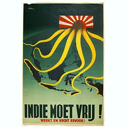
Indie moet vrij vecht ervoor
War propaganda poster by Patrick (Pat) Cokayne Keely, who died in 1970, was a British graphic artist known for his Second World War posters for the Ministry of Informatio...
Place & Date: London, J.Haworth & Brother Ltd, 1944
Selling price: $325
Sold in 2016
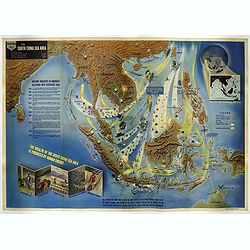
Nav War map No.2 The South China Sea Area.
An unusual and large colored lithograph Pictorial Map of the area around the South China Sea, distributed by the Educational Service Section, Bureau of Naval Personnel, N...
Place & Date: Washington, 1944
Selling price: $1500
Sold in 2017
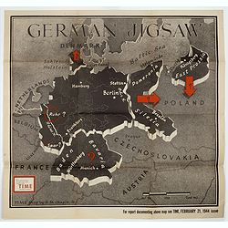
German Jigsaw.
BONUS Map depicting Germany separated into a jigsaw puzzle. "Enlargement of original map drawn for TIME the weekly news magazine" according to note in right han...
Place & Date: New York , Time Magazine, 1944
Selling price: $200
Sold in 2017
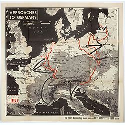
Approaches to Germany.
BONUS Map depicting possible routes into Germany from Russia, France, and Italy. "Enlargement of original map drawn for LIFE" according to note in lower left co...
Place & Date: New York , Time Magazine, 1944
Selling price: $151
Sold in 2018
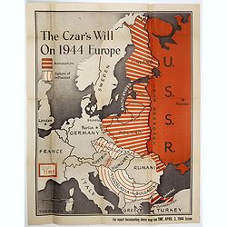
The Czar's Will On 1944 Europe.
Map depicting spread of USSR into Finland and Poland between 1939 and 1944. "Enlargement of original map drawn for TIME The Weekly News Magazine" according to n...
Place & Date: New York , Time Magazine, 1944
Selling price: $250
Sold in 2017
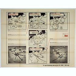
![[No title : Map centered on Philippines]](/uploads/cache/39796-250x250.jpg)
[No title : Map centered on Philippines]
BONUS Map depicting a bird's-eye map centered on Philippines. Design by Ted Kautzky (1896-1953) (Enlargement of original map drawn for Life)."For report documenting ...
Place & Date: New York , Life Magazine, 1944
Selling price: $150
Sold in 2017
![Honorable War Plants [in Japan]](/uploads/cache/39798-250x250.jpg)
Honorable War Plants [in Japan]
Map depicting Japan and industrial war-plants. Design by Robert Macfarlane Chapin Jr.. In right hand side : Enlargement of original map drawn for TIME The Weekly News Mag...
Place & Date: New York , Time Magazine, 1944
Selling price: $375
Sold in 2017

Wacht am Rhein.
Map depicting the German, Dutch, French border line. Design by Robert Macfarlane Chapin Jr.. In left hand side : Enlargement of original map drawn for TIME The Weekly New...
Place & Date: New York , Time Magazine, 1944
Selling price: $150
Sold in 2017
![[No title : Map of China with US air bases]](/uploads/cache/39806-250x250.jpg)
[No title : Map of China with US air bases]
BONUS Map depicting China, Taiwan, part of Japan and Philippines in lower right corner. With a key to US air bases in China. Upper right : Enlargement of original map dra...
Place & Date: New York , Life Magazine, 1944
Selling price: $235
Sold in 2017

By the Left Flank.
Map depicting central Italy, just south of Rome. Design by Robert Macfarlane Chapin Jr.. In lower left hand side : Enlargement of original map drawn for TIME The Weekly N...
Place & Date: New York , Time Magazine, 1944
Selling price: $170
Sold in 2017
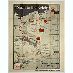
Reach to the Reich.
Map depicting central Italy, just south of Rome. Design by Robert Macfarlane Chapin Jr.. In lower left hand side : Enlargement of original map drawn for TIME The Weekly N...
Place & Date: New York , Time Magazine, 1944
Selling price: $310
Sold in 2017
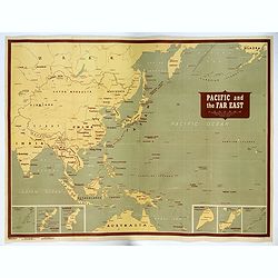
Pacific and the Far East.
A very large US Army and Naval map of The Pacific Ocean and the Far East, published during the second world war. Map covers the western Pacific, as far as Hawaii and the ...
Place & Date: [New York], 1944
Selling price: $1000
Sold in 2017
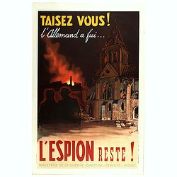
Taisez vous! L'Allemand a fui . . . L'espion reste.
colored Lithograph propaganda poster made during post second war. The poster showing a, unusual, depicting a country destroyed at the beginning of the purification.With a...
Place & Date: Paris, Imprimeur Hénon, 1944
Selling price: $210
Sold in 2018
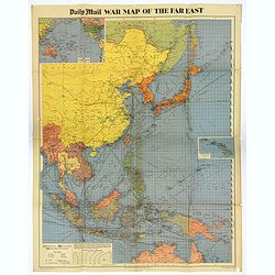
War Map of the Far East.
A large multi-colored poster of the War in the Far East, published by the Daily Mail Newspaper. Map extends from the northern tip of Australia in the south, northward up ...
Place & Date: London, 1944
Selling price: $80
Sold in 2018
![[No title : War Map centered on Philippines]](/uploads/cache/40088-250x250.jpg)
[No title : War Map centered on Philippines]
BONUS Map depicting a bird's-eye map centered on Philippines. Design by Ted Kautzky (1896-1953) (Enlargement of original map drawn for Life)."For report documenting ...
Place & Date: New York , Life Magazine, 1944
Selling price: $160
Sold in 2018
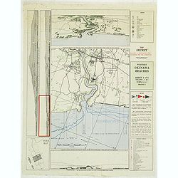
Western Okinawa Beaches Sheet 4 of 6. Top Secret reduced to restricted upon departure for the operation. (Lot contains 2 copies of the map.)
Top secret intelligy map of Western Okinawa Beaches prepared by Comphisgroup twelve and Phisspac Intelligence. With several inset maps and keys. On verso the Hourly heigh...
Place & Date: Washington, 1945
Selling price: $50
Sold in 2012
![A Pictorial Map of North America. [signed by Ernest Dudley Chase]](/uploads/cache/38841-250x250.jpg)
A Pictorial Map of North America. [signed by Ernest Dudley Chase]
Signed example of Ernest Dudley Chase's pictorial map of North America.According to Rumsey: Pictorial map of the North American continent, from Greenland in the north to ...
Place & Date: Winchester, 1945
Selling price: $325
Sold in 2017

Plan of Shanghai - Sheet 1
An exceptionally fine and very detailed map of Shanghai, drawn up by the US Army in 1945 by the Geographical Section of the General Staff, War Office.Originally made in 1...
Place & Date: Washington, 1945
Selling price: $1150
Sold in 2017

Mapa de las yslas Philipinas Luzon . . .
Map of the Philippines. printed on a publication of YANK The army weekly, February 16, 1945. The map has an inset of Manila and vicinity, legend and a key to rail road a...
Place & Date: New York, 1945
Selling price: $255
Sold in 2017
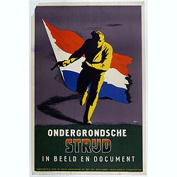
Ondergrondsche strijd. In beeld en document.
Second War Poster designed by Willem Anthonie Oepts (1904 - 1988), published by the Dutch Military Government.The designer Willem Anthonie Oepts (1904 - 1988) is known fo...
Place & Date: Weert, Smeets, 1945
Selling price: $75
Sold in 2018

Free Holland welcomes the soldiers of the Allies.
Poster designed by Pat P. Cokayne Keely for the Dutch Government Information Service (Rijksvoorlichtingsdienst) to welcome the soldiers of the Allies: "Free Holland ...
Place & Date: Smeets, Weert, 1945
Selling price: $50
Sold in 2017

The soldiers of the Netherlands Underground Forces greet the Soldiers of the United Nations.
A poster in English and Dutch designed by Frederick Henri Kay Henrion and printed in lithography right after the liberation. Bi-langual poster: "The soldiers of the ...
Place & Date: Smeets, Weert, 1945
Selling price: $50
Sold in 2017
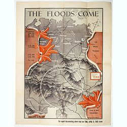
The Floods Come.
BONUS Map depicting Allied movements in Germany. "Enlargement of original map drawn for TIME the weekly news magazine" according to note in right hand corner. D...
Place & Date: Time Magazine, 1945
Selling price: $440
Sold in 2017
Germany's critical minerals
BONUS Map depicting 5 maps showing German steel, airplane, petroleum, etc. production around 1944. Design by Jerry Muscott (Enlargement reprint for Life Magazine, April 2...
Place & Date: New York , Life Magazine, 1945
Selling price: $210
Sold in 2017

Counter attack.
Map depicting the German, Dutch, French border line. Design by Robert Macfarlane Chapin Jr.. In left hand side : Enlargement of original map drawn for TIME The Weekly New...
Place & Date: New York , Time Magazine, 1945
Selling price: $410
Sold in 2017

Formosa. (304)
Nice color printed map of Formosa. With key in upper left corner. Published by The Serial Map Service, who was active from Letchworth and London. The company published on...
Place & Date: Letchworth, Herts, London, The Serial Map Service, 1945
Selling price: $100
Sold in 2020
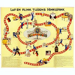
Laf en Flink tijdens Hinkepink.
A Dutch game about the occupation of the Netherlands during World War II. The game is based on the Game of Goose. The game consists of a hundred fields in the shape of a ...
Place & Date: The Hague, 1945
Selling price: $120
Sold
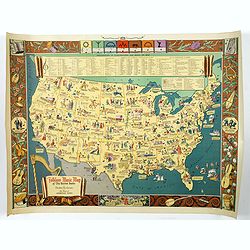
Folklore Music Map of the United States.
A terrific, and unusual, fully colored lithographic map of the Folklore Map of The United States, by Dorothea Dix, and published by the Hagstrom Company Inc of New York i...
Place & Date: New York, 1945
Selling price: $245
Sold in 2018
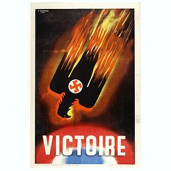
Victoire.
Propaganda poster depicting a black eagle, in flames, marked with the swastika and falling on a blue, white and red ground. Signed and dated on stone Pierre Baudouin (192...
Place & Date: Paris, imprimerie Hénon, 1945
Selling price: $150
Sold in 2018
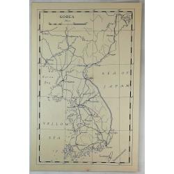
Korea.
A vintage manuscript map, a rare 'Printers Proof' (Unique). Published about 1945 in "The Geographical Journal" by the RGS. On very thick paper.
Place & Date: London, ca 1945
Selling price: $35
Sold in 2019
![[ Pictorial map of the Philippine battlefield ]](/uploads/cache/43612-250x250.jpg)
[ Pictorial map of the Philippine battlefield ]
Pictorial map of central Luzon showing the Japanese Philippine battlefield by HR BIENNETT. Showing a road system, with the land and waters filled with war scenes. In uppe...
Place & Date: Philippines ?, 1945
Selling price: $375
Sold in 2019

Indochine Française.
Poster in the form of a pictorial map showing Vietnam, Indochina in red on yellow, showing Hanoi, Pnom Penh. Designed by Lucien Boucher (1889–1971) for "l'associat...
Place & Date: Paris, Perceval, ca. 1945
Selling price: $2550
Sold in 2019
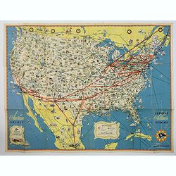
American Airlines Systems Map.
A striking, large poster, or pocket map of American Airlines flagship routes in relation to the air transport system of the United States. Routes flown also include parts...
Place & Date: New York, 1945
Selling price: $50
Sold in 2019

TERRITORIAL GAINS OF THE AXIS POWERS END OF 1940 (WWII Greek Language Propaganda Map)
Hitler, having remedied all losses suffered by Germany under the Treaty of Versailles, started to bring under the authority of the Third Reich all German-speaking peoples...
Place & Date: Alexandria, 1945
Selling price: $120
Sold in 2021
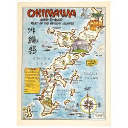
Okinawa mem-o-map part of the Ryukyu Islands.
A Mem-o-Maps published at the end of World War II, marking various memorable spots eg. "10th Army HQ", "77th Division Memorial", airfields and some lo...
Place & Date: 1945
Selling price: $110
Sold in 2019

Philippines Islands.
Wall map sized map of the Philippines on "water proof map no 3 Philippines" according note on lower right corner. No date or publisher. In right corner a key to...
Place & Date: USA, ca. 1945
Selling price: $425
Sold in 2020
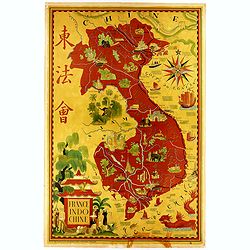
Indochine Française.
Pictorial map showing Vietnam, Indochina in red on yellow, showing Hanoi, Pnom Penh. Decorative poster designed by Lucien Boucher (French, 1889–1971) for "l'associ...
Place & Date: Paris, Perceval, ca. 1945
Selling price: $1700
Sold in 2020

Mem-O-Map of the Philippine Islands.
Postwar map of the Philippines designed to help soldiers revisit their experiences.On board a ship returning home from the Pacific Theater, John Drury got together with o...
Place & Date: United-States, 1945
Selling price: $250
Sold in 2022

Karta Federativne Narodne Republike Jugoslavije.
Rare map of Yugoslavia. With color key. The map was made in the year of the 1941 invasion of Yugoslavia, also known as the April War was a German-led attack on the Kingdo...
Place & Date: Yugoslavia, 1946
Selling price: $200
Sold in 2021

A new map of shanghai published by the Jihsin geographical institute.
Rare town plan of Shanghai published in China, printed in English and Chinese, with an inset of the surrounds of Shanghai and a legend.color printed map, overall size 470...
Place & Date: Shanghay, 1946
Selling price: $600
Sold in 2016

National Savings.
An English National Savings advertising poster, issued just after the second world war. Shows a mythical island treasure map with a slogan underneath extolling the virtue...
Place & Date: London, 1946
Selling price: $37
Sold in 2016
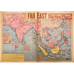
Far East Far from Peace.
A detailed map of the Far East drawn by Edwin L. Sundberg, celebrated staff artist of the Sunday News, from the January 26, 1946 issue. This rare piece of ephemera highli...
Place & Date: New York, 1946
Selling price: $250
Sold in 2018

“Hind darshan” (a view of Hind/ Hindustan)
Very rare chromolithographed propaganda poster in Gujarati script, likely published post partition and assassination of Gandhi but not too much after.The poster showing a...
Place & Date: ca. 1942-1946
Selling price: $1750
Sold in 2017

Kobenhavn / North Seeland.
A nice, large, colorful town plan of the Danish capital, published in 1946. The map covers in some detail from the central train station and the Tivoli Gardens, north up ...
Place & Date: Kobenhavn, 1946
Selling price: $65
Sold in 2018
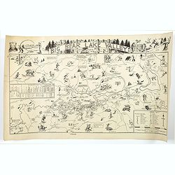
Big Bear Lake Valley.
An unusual 'cartoon' like map of Big Bear Lake Valley, and its Resorts, Sports, and Points of Interest. Big Bear Lake is situated in San Bernadino Co. in California.In ad...
Place & Date: Los Angeles, 1946
Selling price: $260
Sold in 2018

Carte D'Europe - Editions Jacques Petit.
Very decorative large pictorial map of Europe designed in 1946 by Pierre Herault and published in Angers by Editions Jacques Petit in 1955. The separate issued map shows ...
Place & Date: Angers, 1946
Selling price: $165
Sold in 2019
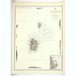
Azores. Corvo and Flores.
A large updated British Sea Chart from an original survey undertaken by Capt. A.T.E. Vidal, R.N. in 1844 of the islands of Corvo and Flores in the Azores Archipelago in t...
Place & Date: London, 1946
Selling price: $45
Sold in 2023
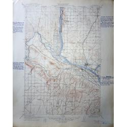
A set of 60 United States Department of the Interior Geological Survey Topographic Maps
The image shown is for Pasco Washington Quadrangle , most are Oregon, Washington and Idaho.The scale is 2 miles to the inch. Many have hand script descriptions in the mar...
Place & Date: 1906 – 1947
Selling price: $120
Sold in 2016
![[GEOGRAPHICAL BOARD GAME] Die Große Weltreise.](/uploads/cache/40270-250x250.jpg)
[GEOGRAPHICAL BOARD GAME] Die Große Weltreise.
A rare post WW II geographical game, made in 1947 by the Flemming publishing house. The player has to travel around the world in 60 steps. The map, although extremely tas...
Place & Date: Hamburg, June 1947
Selling price: $215
Sold in 2017
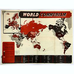
World Communism.
Map Review No. 40. A large folding World map showing all the nations of the world. Each country is shaded differently to reflect where Communism is in power, where Commun...
Place & Date: London, ca 1947
Selling price: $275
Sold in 2018
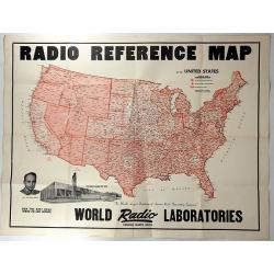
Radio Reference Map.
An interesting advertising map for 'WORLD RADIO LABORATORIES', “The World’s Largest Distributors of Amateur Radio transmitting Equipment”. It shows the monitoring s...
Place & Date: Council Bluffs, 1947
Selling price: $140
Sold in 2018
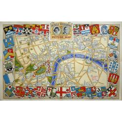
Royal Wedding. The Daily Telegraph Picture Map of the Route.
The Royal Wedding of Princess Elizabeth and Philip Mountbatten was on November 20, 1947. "Map Produced for the "Daily Telegraph" by H.A. & W.L. Pitkin ...
Place & Date: London, 1947
Selling price: $110
Sold in 2019