Browse Listings

Areas in Europe that nazis insist are German in population . . .
A English propaganda broadsheet, showing a map of Europe. In the bottom "The black areas, indicating sections in which German is spoken, were emphasized on maps post...
Place & Date: England, c. 1938
Selling price: $220
Sold in 2018

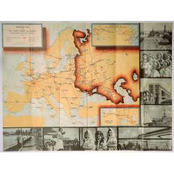
Focal points in Europe as Germany drives to end the status quo.
A very rare English propaganda broadsheet, showing a map of Europe. In the bottom a legend text corresponding to each number on the map. "Nazi agitators demand the r...
Place & Date: England, c. 1938
Selling price: $200
Sold in 2018

Carriers of the New Black Plague.
A powerful satirical commentary on totalitarian control of speech from the first issue of Ken Magazine. "Caught here in all their peculiar beauty by the soul searchi...
Place & Date: Chicago, 1938
Selling price: $120
Sold in 2019
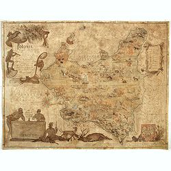
Poloniae Regni amplissimi . . .
Map of Poland drawn by E. Kanarek and T. Lipski, showing the forests and hunting grounds of the Republic of Poland. Published for privatye circulation by the Polish State...
Place & Date: Warsaw, 1938
Selling price: $400
Sold in 2019
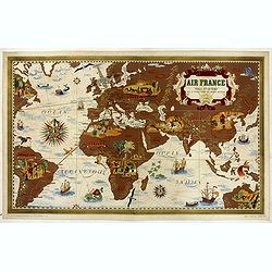
![Air France De jour et de nuit - De nuit et de jour, dans les ciels, nox post Lucem lux post noctem, principales lignes exploitées en 1938-1939. [Planisphère Zodiac Air France].](/uploads/cache/44010-250x250.jpg)
Air France De jour et de nuit - De nuit et de jour, dans les ciels, nox post Lucem lux post noctem, principales lignes exploitées en 1938-1939. [Planisphère Zodiac Air France].
This Stunning constellations planisphere is an iconic surrealist embodiment of the golden age of air travel by Lucian Boucher. Original lithograph advertising planisphere...
Place & Date: Imprimerie Perceval, Paris, 1938
Selling price: $1850
Sold in 2019
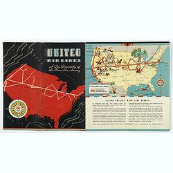
United Airways. A Gay Geography of the Main Line Airway.
A unique United Airlines Booklet, with original wrappers, with color illustrations on each page with pictographic / pictorial maps (16 pages including covers). It is high...
Place & Date: U.S.A., 1938
Selling price: $225
Sold in 2020
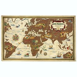
AIR France - Nova et Vetera.
Nova et Vetera " Sur la vieille terre des chemins nouveaux" original lithograph advertising planisphere poster from AIR France, the French airline company. The ...
Place & Date: Imprimerie Perceval, Paris, 1938
Selling price: $1600
Sold in 2020
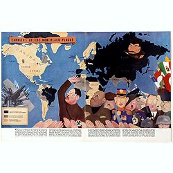
Carriers of the New Black Plague.
A powerful satirical commentary on totalitarian control of speech from the first issue of Ken Magazine. "Caught here in all their peculiar beauty by the soul searchi...
Place & Date: Chicago, 1938
Mission d'études du Haut fleuve Sénegal.
Five maps likely prepared by "La Mission d'Etudes du Fleuve Sénégal" (MEFS) which was a public body responsible for the conduct and execution of all th...
Place & Date: Senegal, ca. 1935-1938
Selling price: $300
Sold in 2017
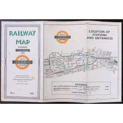
1939 map of the Sydney underground system and it's suburban railway system.
An extremely interesting and rare map of the Sydney underground system and it’s suburban railway system published in 1939. The map clearly takes inspiration from Harry ...
Place & Date: Sydney, 1939
Selling price: $260
Sold in 2020

Creta Candia
Unique manuscript map of Crete. Award-winning manuscript card, prepared by Antonio Raggio for the 11th Congreso de la Union Postal Universal (World Postal Congress) Expos...
Place & Date: Buenos Aires, 1939
Selling price: $250
Sold in 2023
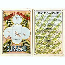
Antilla Holandesas. Curazao.
Unique manuscript map of Curaçao, Bonaire, and Aruba. Award-winning manuscript card, prepared by Antonio Raggio for the 11th Congreso de la Union Postal Universal (World...
Place & Date: Buenos Aires, 1939
Selling price: $375
Sold in 2018
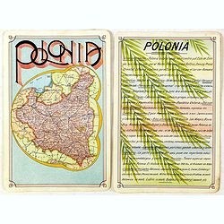
Polonia
Unique manuscript map of Poland. Award-winning manuscript card, prepared by Antonio Raggio for the 11th Congreso de la Union Postal Universal (World Postal Congress) Expo...
Place & Date: Buenos Aires, 1939
Selling price: $400
Sold in 2020
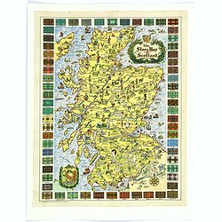
The Story Map of Scotland.
A colorful and detailemap of Scotland, showing the history of that fascinating country in pictorial form. Surrounding the map are the Tartans of 62 differnent Clans. In o...
Place & Date: Chicago, 1939
Selling price: $30
Sold in 2016
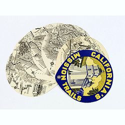
California's Mission Trails.
A most unusual 'disk' shaped series of circular maps taking in the Californian coastline from Los Angeles north to San Francisco America's most beautiful 400 miles.There ...
Place & Date: California, 1939
Selling price: $80
Sold in 2017
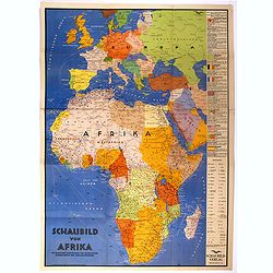
Schaubild von Afrika mit bildlicher Darstellung der wichtigsten Bodenschätze und Wirtschaftgüter.
Decoratively designed economic map of Africa with pictorial representation of the most important mineral resources and economic goods for the respective area.In right han...
Place & Date: München, ca. 1939
Selling price: $750
Sold in 2022
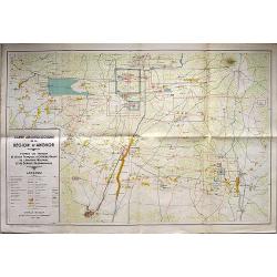
Carte Archeologique de la Region d'Angkor.
A detailed map of the region around Angkor Wat on a scale of 1:40,000, that includes a detailed key in the box at lower left corner. Includes the main ruins at Angkor Tho...
Place & Date: Anon, 1939
Selling price: $160
Sold in 2018
Intourist Map of the Soviet Union and Europe Showing Principal Transportation Connections.
An interesting map - especially as it was published just before WWII. Date is based on "Intourist suggested itineraries for 1939". Soviet Union borders shown in...
Place & Date: New York, 1939
Selling price: $35
Sold in 2019

Newport / Mount Hope Bridge, RI.
One side shows a large, decorative and colorful map of part of Rhode Island, from Warren Point in the south, to Newport in the west, to Bristol in the north, to Cape Cod ...
Place & Date: Bristol, 1939
Selling price: $65
Sold in 2018
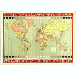
Verzend uw telegrammen via Holland Radio Den Nationalen weg. Gemakkelijk -Zeker - Snel.
Poster showing a world map in Mercator projection. In top and bottom clocks showing the time zones. Red lines connecting The Netherlands with different major hubs in Amer...
Place & Date: The Netherland, 1939
Selling price: $50
Sold in 2019

Republica de Venezuela.
A beautiful hand colored, hand drawn map of Venezuela, prepared for the Buenos Aires 1939 Philatelic Exhibition, with separate text with details of the country in Spanish...
Place & Date: Buenos Aires, 1939
Selling price: $28
Sold in 2019
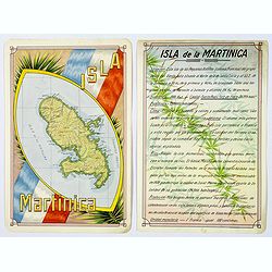
Isla Martinica.
A beautiful hand colored, hand drawn map of the French Caribbean island of Martinique, prepared for the Buenos Aires 1939 Philatelic Exhibition, with separate text with d...
Place & Date: Buenos Aires, 1939
Selling price: $21
Sold in 2019
AIR France - Nova et Vetera 'Sur la vieille terre des chemins nouveaux'.
Nova et Vetera "Sur la vieille terre des chemins nouveaux" original lithograph advertising poster designed for the airline Air France, designed by Lucien Bouche...
Place & Date: Imprimerie Perceval, Paris, 1939
Selling price: $1000
Sold in 2019

Azores. San Miguel.
A large updated sea chart of the island of San Miguel in the Azores, originally surveyed by Capt. A.T.E. Vidal, R.N. in 1844. The chart has had a few new editions, and a ...
Place & Date: London, 1939
Selling price: $50
Sold in 2021
Océan Atlantique Sud, ile de Fernando-Noronha.
Striking and highly detailed chart of Fernando de Noronha, an archipelago of 21 islands and islets in the Atlantic Ocean.Fernando de Noronha is a volcanic archipelago abo...
Place & Date: Paris, 1929, corrected to 1939
Selling price: $150
Sold in 2020
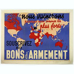
Nous vaincrons parce que nous sommes les plus forts. Souscrivez aux bons d'armement.
"We win because we are the strongest. Support good armaments". Quote by the French Prime Minister Paul Reynaud. French wartime propaganda poster. color printed ...
Place & Date: Paris, M.Dechaux, ca 1939
Selling price: $105
Sold in 2019
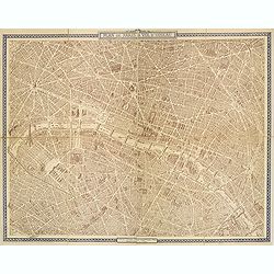
Plan de Paris à vol d'oiseau.
A very detailed plan of Paris for the year 1920. Design by Georges Peltier and published by Blondel la Rougery. Lower left "Ce plan dressé d'après nature est la pr...
Place & Date: Paris, Monroco, 1920-1940
Selling price: $180
Sold in 2013
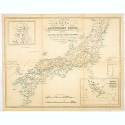
Karte vom japanischen Reiche, nach Originalkarten und astronomischen Beobachtungen der Japaner,die Inseln Kiusiu, Sikok und Nippon. / Philipp Franz von Siebold.
An early 20th-century reproduction of this important map of Japan was made in 1840 by German physician and traveler Philipp Franz Balthasar von Siebold. During his travel...
Place & Date: Tokyo, ca. 1940
Selling price: $550
Sold in 2014

Historical Map of the Old Northwest Territory.
A large, folding lithographic map of the "Old Northwest Territory" in the time of Thomas Jefferson. This map seems to cover the states of Illinois, Indiana, Ohi...
Place & Date: Ohio, ca. 1940
Selling price: $255
Sold in 2016

On the routes of the Flying Clipper Ships.
A fun, attractive pictorial map of North and South America by the famous aviation artist Kenneth Thompson. The Clipper Ships flew from 1931-1946. A poster that is full of...
Place & Date: USA, ca 1940
Selling price: $265
Sold in 2018
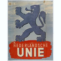
Nederlandsche unie.
Lithographed poster made for The Nederlandse Unie (Netherlands Union) was founded on 24 July, 1940, shortly after the German occupation of the Netherlands. It was a polit...
Place & Date: Netherlands, 1940
Selling price: $100
Sold in 2018
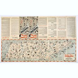
Chuckle Map of Tennessee.
A comic 'look' at the state of Tennessee, packed with highways, towns, points of interest, sports, produce, and lots of cartoon like characters depicting various activiti...
Place & Date: Nashville, ca. 1940
Selling price: $50
Sold in 2018
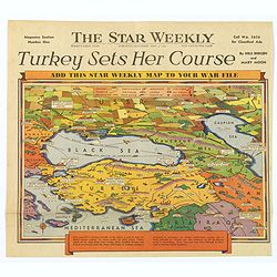
Turkey Sets Her Course / Behind Mediterranean Front.
Two unusual pictorial maps on World War II in Europe, from a Toronto based Canadian weekly newspaper. First map shows Turkey and her surrounding countries, with major tow...
Place & Date: Toronto, 1940
Selling price: $50
Sold in 2017
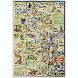
Map of the Black Hills of South Dakota.
A striking and 'busy' map of the Black Hills of South Dakota, "copied from maps compiled by South Dakota State Highway Commission". The entire map is filled wit...
Place & Date: South Dakota, ca. 1940
Selling price: $55
Sold in 2019
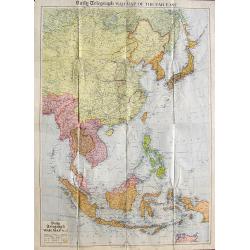
Daily Telegraph War Map of the Far East.
A very large folding map of South-East Asia from Russia until a tip of Australia. Shows transportation routes with distances, oil fields, Allied Naval Bases, and the terr...
Place & Date: London, ca. 1940
Selling price: $40
Sold in 2018
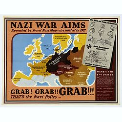
Nazi War Aims. . .
An English wartime propaganda sheet, of "Nazi War Aims, Revealed by Secret Nazi Map - circulated in 1937". The main map shows western Europe, with Germany at it...
Place & Date: Anon, ca. 1940
Selling price: $165
Sold in 2018
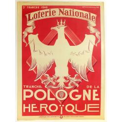
3e tranche 1940. Loterie Nationale. Tranche de la Pologne héroïque.
A beautiful lithograph made by Marcoussis and printed in Paris by Imp LAFAYETTE. More about "Poster History" [+]
Place & Date: Paris, 1940
Selling price: $95
Sold in 2020
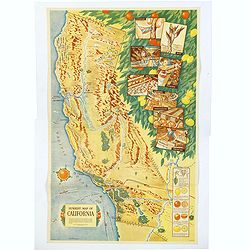
Sunkist Map of California.
A scarce educational map of the Sunkist Fruit Growers guide to operations in California, published during WWII. The map is beautifully presented with several illustrated ...
Place & Date: Los Angeles, 1940
Selling price: $1100
Sold in 2019

L'Intesa Cordiale.
Cover for an Italian caricature book cover, from 1940 by Enrico Gianeri (Gec). "Gec L’INTESA CORDIALE". Signed and dated on the stone lower right.
Place & Date: Milan, 1940
Selling price: $20
Sold in 2020
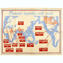
Français, regardez cette carte.
French anti-England propaganda poster showing all of France's conflicts with the English around the world. Dates back to the Vichy political regime. Very popular for the ...
Place & Date: Paris, 1940
Selling price: $200
Sold in 2020

Gold Mine brand.
colorful Texas crate label from the Gold Mine brand and shipped by the Valley Fruit Company of Pharr, Texas. The company’s 111,000 sq. ft. packing facility was pivotal ...
Place & Date: Texas, ca. 1940
Selling price: $15
Sold in 2020

Planta da Cidade de Lisboa.
Folding pictorial plan of the city of Lisbon. This broadside features a Deco-inspired pictographic map of Lisbon on one side, by Jose Espinho, a lithograph. There are sma...
Place & Date: Lisbon, 1940
Selling price: $36
Sold in 2021
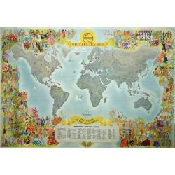
Philips Radio The World of Entertainment.
A decorative, spectacular and rare Philips Radio pictorial promotional world map that features the locations of dozens of global shortwave stations. Design by Ensak.The s...
Place & Date: Rotterdam, Kuhn en zoon, ca. 1940
Selling price: $261
Sold in 2020
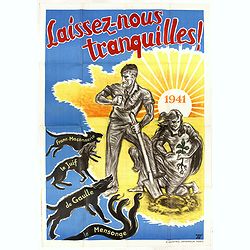
Laissez-nous tranquilles.
French propaganda poster printed by G. Mazeyrie and created by Jé. Dates back to the Vichy political regime. Very popular for the promotion of the National Revolution, t...
Place & Date: Paris, 1941
Selling price: $325
Sold in 2020

Imperial Defense Map.
Interesting piece of ephemera from a supplement in a Japanese boys' magazine published during World War II showing battle scenes and American & Japanese naval positio...
Place & Date: Japan, c. 1941
Selling price: $508
Sold in 2012
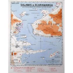
Salamis & Scaramanga.
A "Secret" map was printed by the South African Survey Co, in December 1941, after the German invasion of Greece. Shows a portion of the Saronic Gulf with the S...
Place & Date: South Africa, 1941
Selling price: $70
Sold in 2016
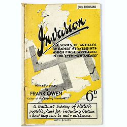
Invasion. A Series of Articles by Expert Strategists with 9 maps.
An interesting small quarto sized 64 page booklet covering Invasion, a series of articles by expert strategists which first appeared in The Evening Standard.A brilliant s...
Place & Date: London / Melbourne, ca. 1941
Selling price: $80
Sold in 2017
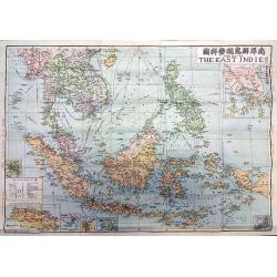
The Map of the East Indies.
A rare map of the East Indies issued by the Singapore branch of the World Book Company, one of China's major bookstores, and edited by Kying Wa Wang and Guan Ching Shy, a...
Place & Date: Singapore, 1941
Selling price: $145
Sold in 2018
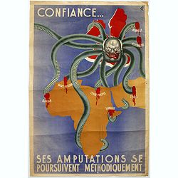
Ses Amputations se Poursuivent Methodiquement.
Propaganda map, produced under the NAZI collaborating Vichy French regime and designed to inspire revulsion and hatred of the English among the French, while frequently d...
Place & Date: Paris, ca. 1941
Selling price: $900
Sold in 2018
![Horta and Pim Bays / Fayal Channel [Azores].](/uploads/cache/43825-250x250.jpg)
Horta and Pim Bays / Fayal Channel [Azores].
Two charts on one sheet of Horta and Pim Bays and the Fayal Channel in the Azores in the Atlantic Ocean, originally published by the Hydrographic Office in 1849, but this...
Place & Date: London, [1849] 1941
Selling price: $105
Sold in 2019

Azores. Fayal Pico and San Jorge.
A large updated sea chart of Fayal (Faial) Pico and San Jorge in the Azores Archipelago in the Atlantic Ocean, first survey in 1844 by Capt. A.T.E. Vidal, R.N. The chart ...
Place & Date: London, 1941
Selling price: $40
Sold in 2020
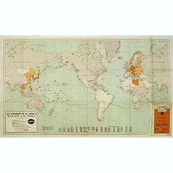
Ross indipendet Oil Co., Canton, O. War map of the World.
World map showing the world during World War II. With a color key lower left to the different powers and bases for American, British, Dutch Russian and Other defense armi...
Place & Date: Erie, ca. 1942
Selling price: $65
Sold in 2012
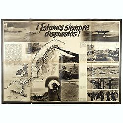
Estamos siempre dispuestos. (We are always ready )
German propaganda poster with text in Castilian and photographs. In the center a map of the European coasts along the North Sea. In top "Estamos siempre dispuestos&q...
Place & Date: Germany, 1942
Selling price: $300
Sold in 2017
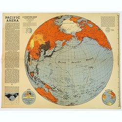
Pacific Arena / One World One War.
A pair of large, brightly colored second world war maps covering the Pacific regions, and the world. Printed as Supplements to 'Fortune' in March 1942. The informative Pa...
Place & Date: New York, 1942
Selling price: $96
Sold in 2017
![[Untitled] Panoramic Pictorial map of the River Nile.](/uploads/cache/42238-250x250.jpg)
[Untitled] Panoramic Pictorial map of the River Nile.
An unusual large pictorial map of the River Nile, printed in English. It shows the river at the Nile Delta and the Mediterranean Sea, with pithy comments about Alexandria...
Place & Date: U.S.A., ca 1942
Selling price: $120
Sold in 2018

The Histomap of Evolution.
To make evolution more easy to understand, and facilitate a life to students - John B. Sparks, who created the Histomap of religion and Histomap of world history, also cr...
Place & Date: Chicago, 1942
Selling price: $310
Sold in 2018

New Map of Singapore Island - Besieged by Japanese. Chicago Daily Tribune, Monday, February 9, 1942
color pictorial map designed by , single sheet from the Chicago Daily Tribune, "This is a new map of Singapore Island, now being besieged by the Japanese. North of t...
Place & Date: Chicago, 1942
Selling price: $575
Sold in 2019

Pilgrim's Map of the Holy Land. . .
A large and striking map of the Holy Land, published in Nazareth during the Second World War. The map shows from the Port of Sidon in the north, south to Gaza, mentioning...
Place & Date: Nazareth, 1942
Selling price: $75
Sold in 2020
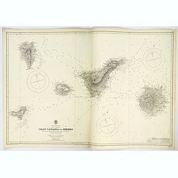
Gran Canaria to Hierro.
A very large double sheet sea chart of Gran Canaria to Hierro in the Canary Islands, originally surveyed by Capt. A.T.E. Vidal and Lieut. W. Arlett, R.N. between 1834-183...
Place & Date: London, 1942
Selling price: $57
Sold in 2023
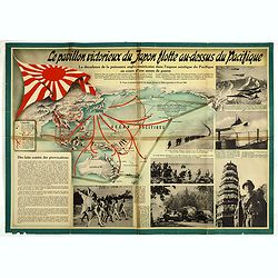
Le pavillon victorieux du Japon flotte au dessus du Pacifique (THE VICTORIOUS FLAG OF JAPAN FLIES OVER THE PACIFIC).
Cartographic propaganda World War II & the Japanese empire. A magnificent large-format propaganda broadside, or ‘wall newspaper’ made in December 1942, during Wor...
Place & Date: Spain, 1942
Selling price: $95
Sold in 2019

Pilgrim's map of the Holy Land : for biblical research, the journey's and deed's of Jesus Christ.
Fine map of the Holy Land with extensive color keys, short legend and key list to the main towns of the region.The map was prepared by Th.F.Mathesy Ph.D. and according to...
Place & Date: Jerusalem, 1942
Selling price: $100
Sold in 2010
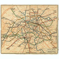
Plan de métro de Paris par Girard et Barrère. Edition de 1942
Miniature metro map of Paris, published by Girard et Barrère, Géographes - Editeurs, 17 rue de Buei, Paris.
Place & Date: Paris, 1942
Selling price: $10
Sold in 2020
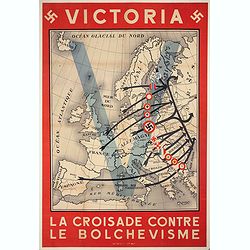
Victoria - La Croisade contre le Bolchevisme.
French propaganda poster printed by Bedos & Cie Paris. Poster published by the German propaganda services in France (Propaganda Abteilung). The launching of the Germa...
Place & Date: Paris, 1942
Selling price: $700
Sold in 2020
Dated Events War Map furnished you the compliments of United Air Lines.
Decorative large format colorful map of the world. Inset maps of the Philippines, Japan and Germany and to the left and right a list of events happened in Europe and the ...
Place & Date: Canada, 1942
Selling price: $200
Sold in 2021

Der Kriegsschauplatz im Stillen Ozean.
Fascinating map of the Theater of War in the Pacific, published in Berlin.The map outlines the various regions of the Pacific controlled by the British, USA and Japan, wi...
Place & Date: Berlin, ca. 1942
Selling price: $100
Sold in 2021
![[Phuket - Harbour]](/uploads/cache/48535-250x250.jpg)
[Phuket - Harbour]
Scarce Japanese chart of Phuket prepared by Daisuke Soejima Daikin and probably the first detailed chart of the region made just after the capture of Thailand by the Japa...
Place & Date: Japan, August 1942
Selling price: $750
Sold in 2023
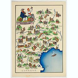
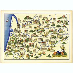
Languedoc - Foix Roussillon.
This is a very decorative, informative map of the Languedoc - Foix Roussillon region in southeastern France, including the towns of Carcassonne, Montpellier,, Albi, Toulo...
Place & Date: France, 1943
Selling price: $40
Sold in 2023
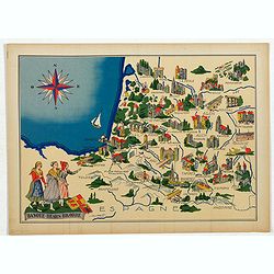
Languedoc - Foix Roussillon.
Very decorative, informative map of Languedoc - Foix Roussillon region in south eastern France. Including the towns of Carcassonne, Montpellier,, Albi, Toulouse, etc.The ...
Place & Date: France, 1943
Selling price: $40
Sold in 2022
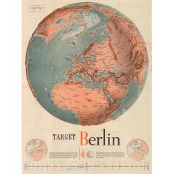
Target Berlin
This large map (broadside) is formally entitled Newsmap. Monday, October 25, 1943, Vol. II No. 27. By F. E. Manning, it is one of the most iconic American WWII propaganda...
Place & Date: Washington D.C., 1943
Selling price: $400
Sold in 2023
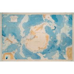
Antarctica. No. 2562. Compiled from all available sources to 1943, including the results of all American exploration from The United States Exploring Expedition, 1839-1840, to The United States Antarctic Service, 1940-1941.
FIRST EDITION. Overall dimensions 85 x 128cm. Original colour printed map of Antarctica, backed onto linen, with the South Pole at the centre, encompassing New Zealand an...
Place & Date: Washington D.C.: Hydrographic Office, under the authority of the Secretary of the Navy. 1943
Selling price: $410
Sold in 2023

AAF Cloth chart Spassk-Dal'Niy. Eastern Asia 1:1,000,000 First edition.
Beautiful escape chart, printed on synthetic silk cloth. These extremely detailed aeronautical charts were issued to pilots during WWII to be worn as neck kerchiefs under...
Place & Date: 1943
Selling price: $50
Sold in 2012
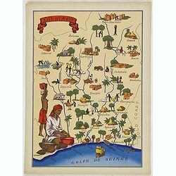
Cote d'Ivoire
Very decorative, informative map of the Ivory coast. The map is filled with buildings, animals, a ship, figures and two locals in their typical dress.In lower left corner...
Place & Date: France, 1943
Selling price: $55
Sold in 2016

St. Pierre et Miquelon.
Very decorative, informative map of St. Pierre and Miquelon. The map is filled with buildings, animals, ships and boats, figures, and a local in the typical dress.In the ...
Place & Date: France, 1943
Selling price: $55
Sold in 2016
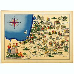
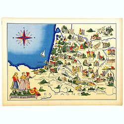
Basque - Bearn - Bigorre.
Very decorative, informative map of Basque - Bearn - Bigorre in south western France. Including the towns of Biarritz, Dax, Bayonne, Lourdes, etc. The map is filled with ...
Place & Date: France, 1943
Selling price: $65
Sold in 2014

La Réunion.
Very decorative, informative map of the island of Reunion. The map is filled with buildings, animals, figures and two locals. With a large compass rose in upper right cor...
Place & Date: France, 1943
Selling price: $60
Sold in 2018

Maroc.
Very decorative, informative map of Morocco. The map is filled with buildings, animals, a ship, figures and three locals in their typical dress.In lower left corner "...
Place & Date: France, 1943
Selling price: $55
Sold in 2016

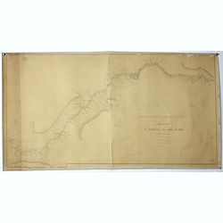
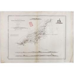
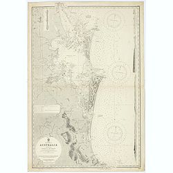
Sheet V East coast of Australia. New South Wales Port Stephens to Tacking Point surveyed by Comr. Fredk. W. Sidney R.N. . . 1862-5. . . with additions and corrections to 1938. . .
Large
Place & Date: London, 1865-1943
Selling price: $100
Sold in 2016
Sheet IX East coast of Australia Queensland Danger Pt. to Cape Monton. . .
Large chart representing east coast of Australia's Queensland showing Danger Pt. to Cape Monton with relief shown by hachures, spot heights and bathymetric soundings. Sur...
Place & Date: London, 1869-1943
Selling price: $110
Sold in 2015
La Réunion.
Very decorative, informative map of the island of Reunion. The map is filled with buildings, animals, figures and two locals. With a large compass rose in upper right cor...
Place & Date: France, 1943
Selling price: $60
Sold in 2016
Basque - Bearn - Bigorre.
Very decorative, informative map of Basque - Bearn - Bigorre in south western France. Including the towns of Biarritz, Dax, Bayonne, Lourdes, etc. The map is filled with ...
Place & Date: France, 1943
Selling price: $60
Sold in 2016