Browse Listings
![[ATLAS] Maps of the Bahama Islands with statics and index.](/uploads/cache/37319-250x250.jpg)
[ATLAS] Maps of the Bahama Islands with statics and index.
A rare atlas of the Bahama Islands published by the official authorities. Illustrated with 20 maps, followed 6 pages index. In the introduction the number of 53,000 inhab...
Place & Date: London, Stanford's geog. Establ., 1926
Selling price: $1200
Sold in 2019
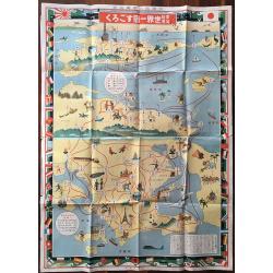
Katei kyōiku sekai isshū sugoroku.
The colorful board game about travelling around the world. Shows a very unusual projection of the world. Many nations flags create the border of the map. The game starts ...
Place & Date: Osaka, 1926
Selling price: $650
Sold in 2016

Sketch map of the Glaciers of Kangchenjunga.
This important 'Sketch-map of the Glaciers of Kangchenjunga’, by E.J. Garwood was prepared on Freshfield's expedition of 1899, a red line in red pen and ink is showing ...
Place & Date: London, Edward Arnold, 1926
Selling price: $700
Sold in 2017

Ceylon showing annual average rainfall up to 1926 inclusive.
A uncommon issue of this detailed map of Ceylon showing the annual average rainfall in a scale of 24 miles to an inch. The Department of Survey of Sri Lanka (also known a...
Place & Date: Colombo, 1926
Selling price: $35
Sold in 2022
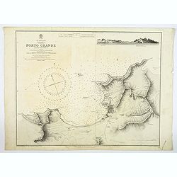
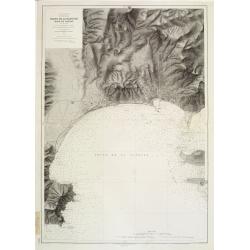
Cape Verde Islands, St. Vincent, Porto Grande. . .
A large maritime chart of Porto Grand on the island of St. Vincent of the Cape Verde islands. The map has tremendous physical detail, plus the settlement of Mindello. The...
Place & Date: London, [1874] 1926
Selling price: $205
Sold in 2019

Cape Verde Islands.
A large double page sea chart of the Cape Verde Islands in the Atlantic Ocean, initially surveyed by Lieut's Vidal & Mudge, R.N. between 1819-21, and first published ...
Place & Date: London, 1926
Selling price: $48
Sold in 2023

Philippine Islands
John Bach map of the Philippines published in Manila. Provinces are illustrated in different colors. Operating railroads on Luzon, Cebu, and Panay appear as thick black w...
Place & Date: Manilla, 1926
Selling price: $425
Sold in 2021
![Carta Marina Universalis 1530 [Facsimile atlas]](/uploads/cache/21559-250x250.jpg)
Carta Marina Universalis 1530 [Facsimile atlas]
Having completed the 1522 edition of Ptolemy, Fries turned his attention to Waldseemuller's 1516 wall-map of the world [Carta Marina]. Fries' version, also a woodcut, was...
Place & Date: Munich ca. 1926
Selling price: $450
Sold

Voies de communication.
The map is published by the Service geographique de l'Indochine.The Frenchman Jules-Léon Dutreuil de Rhins produced at the end of the 19th century a general map of Indoc...
Place & Date: Hanoi, November 1927
Selling price: $120
Sold in 2016
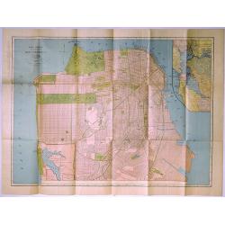
Rand McNally Standard Map of San Francisco.
A pleasing map of the city of San Francisco, California, issued by the Rand McNally and Company in 1927. It covers the entire city from Fort Point and Presidio Park as fa...
Place & Date: Chicago, 1927
Selling price: $10
Sold in 2019
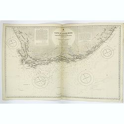
Cape of Good Hope & Adjacent Coasts from Hondeklip Bay to Port Natal.
A very large double sheet British Admiralty sea chart of the Cape of Good Hope in South Africa. It has extensive coastal detail, with lighthouses or beacons, highlighted ...
Place & Date: London, [1867] 1927
Selling price: $300
Sold in 2019

Colonie du Dahomey Carte Routiere dressée au service Géographique de l'A.O.F. Dakar.
Dissected and mounted on linen road map of Dahomey colony, on witch the limits of the state, the colony, and the circle are indicated.
Place & Date: Paris, ca. 1928
Selling price: $325
Sold in 2017

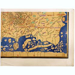
Single sheet from Tabula Rogeriana world map with European section.
Separate single sheet (of 6) with the European section of the [TABULA ROGERIANA] [NUZHAT AL-MUSHTĀQ FI'KHTIRĀQ AL-ĀFĀQ - THE BOOK OF P...
Place & Date: Suttgart, Konrad Miller, 1928
Selling price: $110
Sold in 2017
Single sheet from Tabula Rogeriana world map with the Far East section.
Single sheet from a 6 sheet version of the [TABULA ROGERIANA] [NUZHAT AL-MUSHTĀQ FI'KHTIRĀQ AL-ĀFĀQ - THE BOOK OF PLEASANT JOURNEYS IN...
Place & Date: 1151 BUT Suttgart, Konrad Miller, 1928
Selling price: $325
Sold in 2017
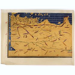
(Single sheet from Tabula Rogeriana world map with North African section.)
Separate single sheet sheet (of 6) with the North African section of the [TABULA ROGERIANA] [NUZHAT AL-MUSHTĀQ FI'KHTIRĀQ AL-ĀFĀQ - TH...
Place & Date: 1151 BUT Suttgart, Konrad Miller, 1928
Selling price: $110
Sold in 2017
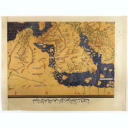
Single sheet from Tabula Rogeriana world map with Arabian Peninsular section.
Separate single sheet (of 6) with the Arabian Peninsular and Egypt section of the [TABULA ROGERIANA] [NUZHAT AL-MUSHTĀQ FI'KHTIRĀQ AL-ĀF...
Place & Date: 1151 BUT Suttgart, Konrad Miller, 1928
Selling price: $110
Sold in 2017

Single sheet from Tabula Rogeriana world map with Siberia and Tartary section.
Separate single sheet (of 6) with the Siberia and Tartary section of the [TABULA ROGERIANA] [NUZHAT AL-MUSHTĀQ FI'KHTIRĀQ AL-ĀFĀQ - TH...
Place & Date: 1151 BUT Suttgart, Konrad Miller, 1928
Selling price: $100
Sold in 2017

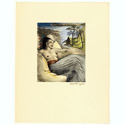
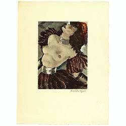
Dessins de Mariette Lydis pour illustrer les Fleurs du Mal. (PL V. Les Bijoux)
"Les Bijoux" - Lithography enhanced with watercolors and signed in pencil by Mariette Lydis, to illustrate Baudelaire's poems of "Les Fleurs du Mal".M...
Place & Date: Paris, G.Govane, 1928
Selling price: $40
Sold in 2018
Dessins de Mariette Lydis pour illustrer les Fleurs du Mal. (PL VI. Parfum Exotique)
"Parfum Exotique" - Lithography enhanced with watercolors and signed in pencil by Mariette Lydis, to illustrate Baudelaire's poems of "Les Fleurs du Mal&qu...
Place & Date: Paris, G.Govane, 1928
Selling price: $50
Sold in 2018

Dessins de Mariette Lydis pour illustrer les Fleurs du Mal. (PL I. Au Lecteur)
"Au Lecteur" - Lithography enhanced with watercolors and signed in pencil by Mariette Lydis, to illustrate Baudelaire's poems of "Les Fleurs du Mal".M...
Place & Date: Paris, G.Govane, 1928
Selling price: $35
Sold in 2018

Dessins de Mariette Lydis pour illustrer les Fleurs du Mal. (PL XII. Un Fantome - III Le Cadre)
"Un Fantome" - "Le Cadre" - Lithography enhanced with watercolors and signed in pencil by Mariette Lydis, to illustrate Baudelaire's poems of "Le...
Place & Date: Paris, G.Govane, 1928
Selling price: $50
Sold in 2018
Dessins de Mariette Lydis pour illustrer les Fleurs du Mal.
Lithography enhanced with watercolors and signed in pencil by Mariette Lydis, to illustrate Baudelaire's poems of "Les Fleurs du Mal".Mariette Lydis (Vienna 188...
Place & Date: Paris, G.Govane, 1928
Selling price: $60
Sold in 2018

Pictorial map of New York City. . .
A lovely town plan of New York City, published by Arthur Crosby services, in 1928, on behalf of the Chase National Bank, which is very interesting, as the published date ...
Place & Date: New York, 1928
Selling price: $375
Sold in 2018

Aquellos Polvos.
Number 23. "That dust..", taken from "Los Caprichos" - "The Sleep of Reason produces monsters." Original etching and aquatint made by Manuel...
Place & Date: Barcelona 1928
Selling price: $80
Sold

Pleasure Island.
Pleasure Island: Being A Plan in the Old Manner of the Lake Island in Canada which Mr Winston Churchill is said to covert.From Punch, September 11th 1929. An amusing map ...
Place & Date: London, 1929
Selling price: $55
Sold in 2012

Pleasure Island.
Pleasure Island: Being A Plan in the Old Manner of the Lake Island in Canada which Mr Winston Churchill is said to covert.
Place & Date: London, 1929
Selling price: $50
Sold in 2017
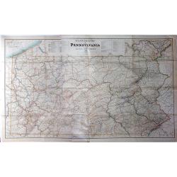
Steam Railroad Map of Pennsylvania.
A huge map, Issued by the Public Service Commission in 1929, by J. W. Clement Co., Matthews-Northrup Works, Buffalo, N. Y. This large folding map is the late twenties ver...
Place & Date: Buffalo, 1929
Selling price: $130
Sold in 2017
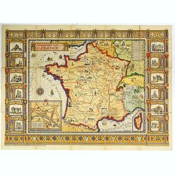
The Picture Map of France.
A large, colorful picture map of France, published by Bowker Co. in New York in 1929. The map was designed and drawn by Harold Haven Brown.This lovely map shows historica...
Place & Date: New York, 1929
Selling price: $50
Sold in 2018
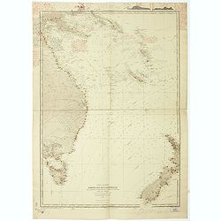
Ocean Pacifique. Partie Est de l'Australie... N.elle Zélande...
Large French sea chart featuring the eastern coast of Australia (Queensland, New South Wales and Tasmania ), New Zealand, New Guinea, New Caledonia, New Hebrides, New Bri...
Place & Date: France, 1897-1929
Selling price: $500
Sold in 2021

Mer de Chine et Grand Archipel d'Asie.
Large French sea chart featuring the Philippines, the coasts of China, Malaysia and Indonesia.On the back of the map, inscriptions in pencil indicate that the map figures...
Place & Date: France, 1897-1929
Selling price: $950
Sold in 2018

Pleasure Island : Being A Plan in the Old Manner of the Lake Island in Canada which Mr Winston Churchill is said to covert.
From Punch, September 11th, 1929.A satirical map attacking Churchill in his "Wilderness Years." In May of 1929, the Conservative government failed to gain reele...
Place & Date: London, 1929
Selling price: $75
Sold in 2019

A Map of Old Boston in the Commonwealth of Massachusetts.
A quaint and charming pictorial map of the tourist sites of downtown Boston as seen in 1929. Buildings and streets are clearly marked. This map was drawn by Charles R. Ca...
Place & Date: Boston, 1929
Selling price: $300
Sold in 2020
Congo Nova Descriptio.
Beautiful and decorative pictorial map of Congo, showing different tribes of this area. The poster carries a wealth of information and presents a selection of traditional...
Place & Date: Paris, 1930
Selling price: $750
Sold in 2021
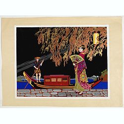
Art Deco gouache with Japanese scene.
Lovely art-deco gouache by Lucien Baubaut of an elaborately robed Japanese woman. The colors are simply stunning jewel-toned emerald, violet, deep purple, saffron and tan...
Place & Date: Paris, ca. 1930
Selling price: $150
Sold in 2020
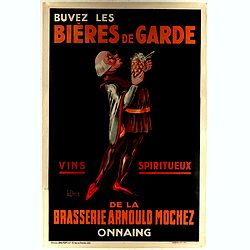
Buvez les bières de garde de la brasserie Arnould Mochez - Onnaing - Vins Spiritueux.
Famous poster from 1930 for the promotion of Guard beers. Brewed at Arnould Moquer, in the village of Onnaing in northern France. The poster depicts a bold man, holding a...
Place & Date: Paris, 1930
Selling price: $140
Sold in 2021
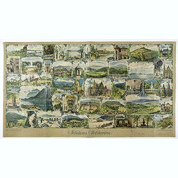
Schönes Schlesien. / Das malerische Breslau.
Publicity leaflet for Breslau which was the capital of what was until 1945 the Prussian province of Silesia. Design by Franz Huth. On verso other touristic places to go t...
Place & Date: Breslaw, ca. 1930
Selling price: $100
Sold in 2020

Baiser d'Anis Apéritif.
Advertising lithographed poster for "Baiser d'Anis Apéritif".
Place & Date: Paris, between 1925 and 1930
Selling price: $75
Sold in 2023
![[Goose game board] Giuoco del Barone.](/uploads/cache/48440-250x250.jpg)
[Goose game board] Giuoco del Barone.
An Italian Goose game of 76 squares. Printed by Adriano Salani.In the center "REGOLE DEL GIUOCO"T. Tira da tutti.P. Paga al Giuoco.V. Va al Num. indicato di ogn...
Place & Date: Florence, ca. 1930
Selling price: $50
Sold in 2022

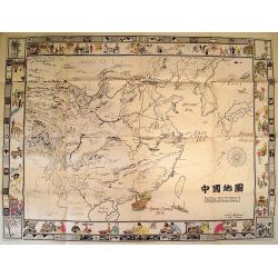
Chinese folding wall map of America.
Uncommon wall map of America, all in Chinese characters. In lower bottom Chinese manuscript characters.
Place & Date: China c. 1930
Selling price: $80
Sold

Girl.
Signed water color made by Roger Berkmans (1900-) made as a poster design.On verso a label of Etablissements O. De Rycker S.A. Ateliers d'Impressions d'Art Publicité. Fo...
Place & Date: Brussels c. 1930
Selling price: $110
Sold
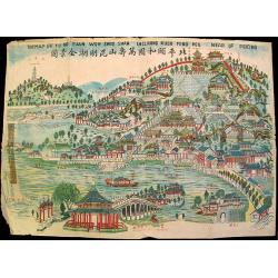
The Map of Yu Ho Yuan Won Shou Shan Including Kuen Ming Hou Near of Peking.
Charming ephemeral map of Peking's Summer Palace (Yihe Yuan) created during China's Republican Period. The map features Longevity Hill and its numerous halls and pavilion...
Place & Date: Beijing, c. 1930
Selling price: $35
Sold
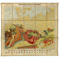
Kleine Geologische Karte von Deutschland. hrsg. von der Preussischen Geologischen Landesanstalt 1930.
Geological map (1:2.000.000) showing Germany and Poland and made by Walter Schriel (1892-1959).Printed by Berliner Lithographisches Institut, Berlin.Provenance : Foundati...
Place & Date: Berlin, c. 1930
Selling price: $50
Sold in 2016
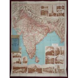
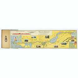
Tourist map of India, Indian State Railways.
An attractive large folding full color pictorial tourist map of India, showing Tibet to the north, Burma to the east, Ceylon in the south. With many photographic illustra...
Place & Date: London, 1930
Selling price: $210
Sold in 2016
![Le voyage du missionnaire. [board game]](/uploads/cache/37521-250x250.jpg)
Le voyage du missionnaire. [board game]
A Goose game board with in four corner missionary scenes in the four continents and in center "N°. 60 Arrivée à la Mission florisante", with Asians people he...
Place & Date: Vanves (France), ca. 1930
Selling price: $200
Sold in 2019

Friendly Service Map of the Commonwealth of Ohio.
A scarce map of the Commonwealth of Ohio, published by the Mobile Oil Company between the wars. A fun and informative map with numerous topical small illustrations, place...
Place & Date: Ohio, ca 1930
Selling price: $75
Sold in 2019
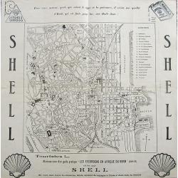
Plan de Tunis.
A scarce old street map of Tunis published by Shell. Includes a key with 21 addresses. Verso with curious advertisements.
Place & Date: Paris, ca. 1930
Selling price: $60
Sold in 2017

The Central part of Boston, Massachusetts, showing transportation lines of the Boston Elevated Railway.
A very nice folding plan of central Boston, highlighting transportation lines within the city during the 1930's.The two lower corners, and the entire top margin of the ma...
Place & Date: Boston, ca. 1930
Selling price: $105
Sold in 2017

China Manchuria and Mongolia.
A large and concise map of China, Manchuria and neighboring Mongolia. With its original biscuit colored paper wrappers, and publisher's advertisements. Lower left has ins...
Place & Date: London, ca. 1930
Selling price: $85
Sold in 2017
The Suez Canal.
A folding map of "The World's most Important Waterway". Complete with small index map bottom right corner, eight small colored illustrations along the canal, a ...
Place & Date: Port Said (Egypt), ca. 1930
Selling price: $275
Sold in 2017
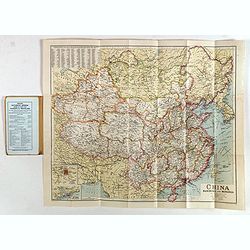
China Manchuria and Mongolia.
A large and concise map of China, Manchuria and neighboring Mongolia. With its original biscuit colored paper wrappers, and publisher's advertisements. Lower left has ins...
Place & Date: London, ca. 1930
Selling price: $120
Sold in 2019
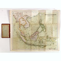
East Indies. (Malay, or East Indian Archipelago with Burma & Siam)
Folding map of the East Indies, Indonesia, Indochina, Thailand, Burma, the Malay Peninsula, Borneo, the Philippines, Sumatra, Java, Celebes.Sifton, Praed & Co., Ltd. ...
Place & Date: London, ca. 1930
Selling price: $120
Sold in 2017
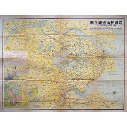
A COMPREHENSIVE MAP OF NANKING-SHANGHAI-HANGCHOW AND NINGPO.
A large litho map of the Chinese region of Shanghai and the important cities to the west of Nanking, Hangchow, and Ningpo.
Place & Date: Anon, ca. 1930
Selling price: $160
Sold in 2018

(Publicity) - Toujours Extra Alliés.
Publicity poster designed by Gerard (Marie Eugène Valentin) Saulou, who signed under this pseudonym OK Girard. He illustrated many books, posters and advertisements in t...
Place & Date: Paris, 1930
Selling price: $30
Sold in 2018

(Publicity) Domaine Eckau comte de Pahlen. - La premiére et la plus ancienne marque de kummel.
Original chromo lithography of an in-store display for a liqueur from the "Domaine Eckau" (KummcI) in Russia. The "Domaine Eckau" liqueur was made acc...
Place & Date: Paris, 1930
Selling price: $100
Sold in 2024

The Cape Ann Trail.
A large folding map of the Cape Ann trail in Massachusetts. The map has 28 red numbered points of reference, which correspond to the small, uncolored vignettes that frame...
Place & Date: Gloucester, 1930
Selling price: $55
Sold in 2018

(Art déco
Outstanding "art deco" gouache (unsigned) from the workshop of "Robert Pichon. Ateliers de Dessin et Lithographie – 10, rue Rochechouart – Paris. The g...
Place & Date: Paris, ca. 1930
Selling price: $800
Sold in 2020

Art déco gouache.
Outstanding "art deco" gouache (unsigned) from the workshop of "Robert Pichon. Ateliers de Dessin et Lithographie – 10, rue Rochechouart – Paris. The ...
Place & Date: Paris, ca. 1930
Selling price: $400
Sold in 2020

The Creole City of New Orleans.
A large, decorative poster extolling the virtues of the all American city of New Orleans. It extends from Lake Pontchartrain and Spanish Fort, southwards, passing the Bay...
Place & Date: New Orleans, 1930
Selling price: $155
Sold in 2018

A Map of Olde Boston prepared in commemoration of the Tercentary of Massachusetts Bay Colony 1630-1930.
A double-sided brochure produced to commemorate the 300 year foundation of the Colony of Massachusetts Bay. On one side is the map of Boston, surrounded by contemporary a...
Place & Date: Boston, 1930
Selling price: $60
Sold in 2018
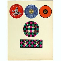
Five Art déco labels.
5 Lithographed perfume labels laid on original cardboard sheet. A striking example of commercial artworks produced by the artist and graphic designer Robert Pichon and hi...
Place & Date: Paris, between 1925 and 1930
Selling price: $60
Sold in 2021
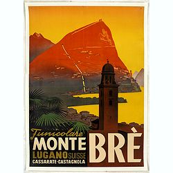
Funicolare Monte Brè Lugano Suisse. Cassarate-Catagnola.
Rare and authentic poster of Lake Lugano, situated in the Switzerland mountains, with a view of the Funicolare of Monte Brè.Designed by Otto Ernst and printed and publis...
Place & Date: Lugano, ca. 1930
Selling price: $1500
Sold in 2024
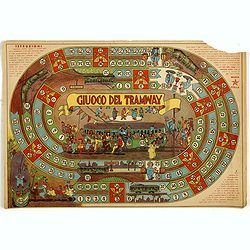
Giuco Del Tramway.
Game of the goose with an animated path of 63 numbered squares, spiral, counter clockwise, centripetal (like a goose game), illustrated with a crowded tram that has to fo...
Place & Date: Italy, ca. 1930
Selling price: $95
Sold in 2019

The House Beautiful Old Massachusetts Map of Houses showing their location, type and other information. . .
color pictorial map of Massachusetts, with decorative border showing those oldest homes from colonial and revolutionary houses. Designed by Raymond Lufkin (1899–1978) w...
Place & Date: 1930
Selling price: $90
Sold in 2020

Malaya 1931
An interesting map of Malaysia with Singapore, dated 1931, and it’s Islands, showing main roads and railways. The States are defined by color.Published under the Direct...
Place & Date: London, 1931
Selling price: $250
Sold in 2016

North West Louisiana Fish and Game Preserve.
A different map of the North West Louisiana Fish & Game Preserve in 1931. Produced in New Orleans by the Department of Conservation commissioner, Robert S. Maestri. D...
Place & Date: New Orleans, 1931
Selling price: $6
Sold in 2017

Inde N-E., Tibet.
Very detailed map of Tibet, with a color code to British, Chinese and Indo-French possessions. From "Atlas Universel" by Bagge and D. Aïtoff.
Place & Date: Paris, 1931
Selling price: $100
Sold in 2021

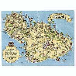
Island of Maui.
A fun, humorous, whimsical map of the Hawaiian island of Maui by Ruth Taylor White. With vibrant colors, the map was issued by the Hawaiian Tourist Bureau of Honolulu.On ...
Place & Date: Boston, ca 1931
Selling price: $45
Sold in 2018
Island of Maui.
A fun, humorous, whimsical map of the Hawaiian island of Maui by Ruth Taylor White. With vibrant colors, the map was issued by the Hawaiian Tourist Bureau of Honolulu.On ...
Place & Date: Boston, ca 1931
Selling price: $75
Sold in 2020
![Animated Map[s] of New Brunswick / Quebec / Ontario / Manitoba.](/uploads/cache/45892-250x250.jpg)
Animated Map[s] of New Brunswick / Quebec / Ontario / Manitoba.
A set of four lovely provincial Canadian map liberally spiced with a touch of humor. Beginning with New Brunswick the map shows us the lay of the land, with a lot of char...
Place & Date: Canadian Ministry for the Interior, ca 1931
Selling price: $51
Sold in 2020
![Mer Méditerranée - Partie Ouest. [5321]](/uploads/cache/23547-250x250.jpg)
Mer Méditerranée - Partie Ouest. [5321]
Large chart centered on the western part of the Mediterranean Basin from the Strait of Gibraltar as far as the Dalmatian coast, with soundings indicated in meters.Surroun...
Place & Date: Paris [1914] corrections to 1931
Selling price: $180
Sold
![Mer Méditerranée - Partie Est. [5322]](/uploads/cache/23548-250x250.jpg)
Mer Méditerranée - Partie Est. [5322]
Large chart centered on the eastern part of the Mediterranean, with soundings indicated in meters.Surrounded by 28 inset plans of the main European African and Asian town...
Place & Date: Paris [1914] corrections to 1931
Selling price: $285
Sold
Mer Méditerranée - Côte de France - Golfe de la Napoule Rade de Cannes. . .
Large centered on the Gulf of La Napoule with the harbour of Cannes, the islands Sainte Marguerite and Saint Honorat on the right side. Showing towns, buildings, banks, ...
Place & Date: Paris, 1903 updated 1931
Selling price: $600
Sold

Atlas de géographie economique de la Paléstine.
Impressive atlas including historical, geographical and economical maps of Israel from the earliest time. The 135 maps are printed in color. One of the 3 title pages with...
Place & Date: Paris 1932
Selling price: $260
Sold
![Mer Adriatique. Environs de Raguse (Dubrovnik). Troisième Feuille. Gravosa-Raguse-Breno.. [278]](/uploads/cache/23474-250x250.jpg)
Mer Adriatique. Environs de Raguse (Dubrovnik). Troisième Feuille. Gravosa-Raguse-Breno.. [278]
Large scale coastal chart showing a stretch of Dalmatian coast centered on Dubrovnik and covering the area from Verbitza as far as Cavtat.With 2 large inset plans illustr...
Place & Date: Paris [1820] 1932
Selling price: $75
Sold in 2023

Port of Volendam.
Original water color-design made by Elizabeth Whitney Moffatt and Gratiane de Gardilanne for their famous book The National Costumes of HollandThe background is consistin...
Place & Date: Netherlands / London 1932
Selling price: $4500
Sold

Tasmania formerly Van Diemen Land.
Admiralty chart of Tasmania based on surveys of M.Flinders, P.P.King, J.L.Stokes, Burnett, and James Sprent, published in 1860 and corrected till 1932.
Place & Date: London, 1860 updated for 1932
Selling price: $110
Sold in 2009
Picture Map of China.
Splendid Art Deco map of China designed to interest and inform children about the country of China. The map is intended to be colored, with the four seasons represented i...
Place & Date: New York, 1932
Selling price: $675
Sold in 2010
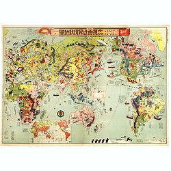
Japanese Stereotype Map of the World from 1932 Share Hitome de wakaru Manga sekai genjō chizu. At a glance: Cartoon Map of the Current World Situation. 目でわかる 漫画世界現状地圖
An extraordinary satirical map of the world was seen through Japanese eyes in the early 1930s as Japanese imperial ambitions strengthened. The map was published as an edi...
Place & Date: Tokyo, Showa 7, or 1932
Selling price: $6000
Sold in 2016
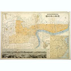
Plan of Shanghai.
A rare plan in Japanese of the Chinese super city of Shanghai, but with individual street names in English. The focus is on central Shanghai and the Bund, the key financi...
Place & Date: Shanghai, 1932
Selling price: $375
Sold in 2017
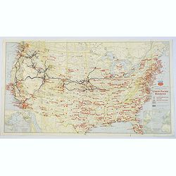
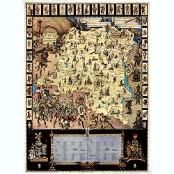
Military Map of the United States / Illustrated Gettysburg Battlefield Map.
The first map of this pair is an attractive general map of the USA Issued by the Union Pacific Railroad during WWII, pictorially showing all the Naval Bases, Army Camps, ...
Place & Date: Chicago, 1942 - Pennsylvannia, 1932
Selling price: $40
Sold in 2019