Browse Listings

Karte von Europa im Jahre 1870 nach einem französischen Holzschnitte.
Satirical illustration by Paul Hadol showing disposition of power in Europe at the beginning of 1870. Satirical print depicting a map of Europe in which the countries are...
Place & Date: Hamburg, Fuchs, 1914
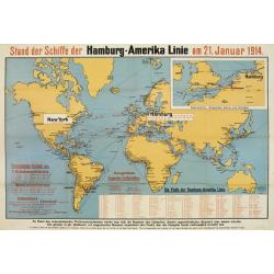
Stand der Schiffe der Hamburg - Amerika Linie am 21. Januar 1914.
Map of the world showing the routes covered by the Hamburg-Amerika fleet.In top right corner inset enlarged map of the coastline around the English Channel as well as the...
Place & Date: Hamburg 1914
Selling price: $100
Sold

Pl. 1. - Femme en robe à la polonaise.
From Galerie des modes et costumes français dessinés d'après nature 1778-1787. Réimpression accompagnée d'une préface par M. Paul Cornu.Beautiful reissue done by th...
Place & Date: Paris, 1912-1914
Selling price: $400
Sold in 2012

Pl. 2. - Robe à la polonaise.
From Galerie des modes et costumes français dessinés d'après nature 1778-1787. Réimpression accompagnée d'une préface par M. Paul Cornu.Beautiful reissue done by th...
Place & Date: Paris, 1912-1914
Selling price: $60
Sold in 2012

Pl. 3. - Petite-Maitresse en robe à la polonaise.
From Galerie des modes et costumes français dessinés d'après nature 1778-1787. Réimpression accompagnée d'une préface par M. Paul Cornu.Beautiful reissue done by th...
Place & Date: Paris, 1912-1914
Selling price: $60
Sold in 2012

Pl. 4. - Femme de qualité en déshabillé.
From Galerie des modes et costumes français dessinés d'après nature 1778-1787. Réimpression accompagnée d'une préface par M. Paul Cornu.Beautiful reissue done by th...
Place & Date: Paris, 1912-1914
Selling price: $50
Sold in 2012

Marchande de modes.
From Galerie des modes et costumes français dessinés d'après nature 1778-1787. Réimpression accompagnée d'une préface par M. Paul Cornu.Beautiful reissue done by th...
Place & Date: Paris, 1912-1914
Selling price: $70
Sold in 2012

Grande robe à la française.
From Galerie des modes et costumes français dessinés d'après nature 1778-1787. Réimpression accompagnée d'une préface par M. Paul Cornu.Beautiful reissue done by th...
Place & Date: Paris, 1912-1914
Selling price: $70
Sold in 2012

Pl. 8. - Robe à la Circassienne.
From Galerie des modes et costumes français dessinés d'après nature 1778-1787. Réimpression accompagnée d'une préface par M. Paul Cornu.Beautiful reissue done by th...
Place & Date: Paris, 1912-1914
Selling price: $60
Sold in 2012

Pl. 21. - Polonaise aux manches à la circassienne.
From Galerie des modes et costumes français dessinés d'après nature 1778-1787. Réimpression accompagnée d'une préface par M. Paul Cornu.Beautiful reissue done by th...
Place & Date: Paris, 1912-1914
Selling price: $60
Sold in 2011
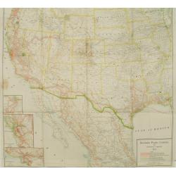
Southern Pacific Company and proprietary companies.
Map of the routes of the Southern Pacific Railway throughout California with connections to other parts of the United States. With inset maps of Los Angeles, San Francisc...
Place & Date: Chicago & New York, 1915
Selling price: $30
Sold
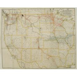
Map showing Great Northern Railway System..
Map of the rail way routes of the railway systems throughout the northern parts of the United States.
Place & Date: Chicago & New York, 1915
Selling price: $150
Sold

Les insects malfaisants.
The artist Walter Vaes made this etching after the invasion of the German army into Antwerp in 1914.In the air an army of Grasshoppers and other insects on the ground, An...
Place & Date: Belgium ,ca. 1915
Selling price: $50
Sold in 2008
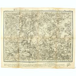
Government Minsk. - Russland 1:126,000 V. XVII.6.
Folding military topographic map of part of Belarus, issued by the General Staff of the German Army. Scale 1:126000 (3 km (Werst) in 1 inch). Centered on Sluzk.Along uppe...
Place & Date: Germany, 1915
Selling price: $25
Sold in 2021
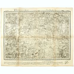
Government Minsk u. Wilna Mirr Blatt 5. - Russland 1:126,000 V. XVI.5.
Folding military topographic map of part of Belarus, issued by the General Staff of the German Army. Scale 1:126000 (3 km (Werst) in 1 inch). Centered on Mir.Along upper ...
Place & Date: Germany, 1915
Selling price: $21
Sold in 2021
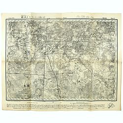
Government Minsk. Kopyl Blatt 6. - Russland 1:126,000 V. XVI.6.
Folding military topographic map of part of Belarus, issued by the General Staff of the German Army. Scale 1:126000 (3 km (Werst) in 1 inch). Centered on Schazk.Along upp...
Place & Date: Germany, 1915
Selling price: $20
Sold in 2021
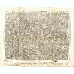
Government Minsk. Klezk Blatt 5. - Russland 1:126,000 V. XVII.5.
Folding military topographic map of part of Belarus, issued by the General Staff of the German Army. Scale 1:126000 (3 km (Werst) in 1 inch). Centered on Sinjawka.Along u...
Place & Date: Germany, 1915
Selling price: $21
Sold in 2021
Government Wilna u. Kowno Widsy Blatt 5. - Russland 1:126,000 V. XII.5.
Folding military topographic map of part of Belarus, issued by the General Staff of the German Army. Scale 1:126000 (3 km (Werst) in 1 inch). Centered on Swenzjany.Along ...
Place & Date: Germany, 1915
Selling price: $10
Sold in 2016
Government Minsk u Kowno. Glubokoje Blatt 6.- Russland 1:126,000 V. XII.6.
Folding military topographic map of part of Belarus, issued by the General Staff of the German Army. Scale 1:126000 (3 km (Werst) in 1 inch). Centered on Glubokoje.Along ...
Place & Date: Germany, 1915
Selling price: $10
Sold in 2016
GovernmentWilna u. Minsk. Dokschitzy Blatt 6.- Russland 1:126,000 V. XIII.6.
Folding military topographic map of part of Belarus, issued by the General Staff of the German Army. Scale 1:126000 (3 km (Werst) in 1 inch). Centered on Budslaw.Along up...
Place & Date: Germany, 1915
Selling price: $10
Sold in 2016

South Manchura Railway Train Service May 1 to April 30, 1915.
A 100 year's old Time Table of the South Manchuria Railway Train Service printed in Japan..
Place & Date: ManshuNichi-Shimbun, 1915
Selling price: $65
Sold in 2017
Map of Japan, Korea, Manchuria North China published by the International Sleeping Car Co.
> A more than 100 years old folding publicity map showing a map of Japan, Korea and Eastern China. The map shows pictorial representations of three cruise ships, a tr...
Place & Date: Yokohama, Japan Gazette Press, 1915
Selling price: $140
Sold in 2018

Der Weltkrieg. World War I post card)
During the Great War, when the only means of communicating news to the masses was by newspapers and weekly illustrated magazines, the ‘war’ or 'military' picture post...
Place & Date: Germany, 1915
Selling price: $60
Sold in 2018

Mais regarde toi donc mourir, dans l'éclat de ma loyale épée, Ô sorciere immonde !
Adolphe Léon Willette (30 July 1857 – 4 February 1926) was a painter, illustrator, poster artist, lithographer and French cartoonist. He has been one of the designer o...
Place & Date: Paris, H.Chachoin, 1915
Selling price: $50
Sold in 2020
Avis. . .
A First World War poster of the War Ministry, "WARNING OF THE MINISTRY OF WAR" of 1915, concerning the destruction of the homing pigeons, Implementation of Arti...
Place & Date: Paris, 1915
Selling price: $170
Sold in 2019

L'Impero della preda ossia la Piovra d'Absburgo.
Rare anti-German propaganda printed in occasion of the entry into the war of Italy during the first World War. The Empire Austro-Hungarian is depicted as an octopus that ...
Place & Date: Milan, ca.1915
Selling price: $960
Sold in 2019
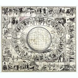
Goose board game type, on the thematic of Jules Vernes World tour in 80 days.
VERY RARE, PRINT BEFORE colorING OR PROOF. Goose board game representing scenes from Jules Verne’s 1872 novel, with thumbnail illustrations numbered from 1 to 80 arrang...
Place & Date: Paris, Roche Frères, 1880-1915
Selling price: $500
Sold in 2020
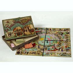
Le Tour du Monde en 80 jours d'après Jules Verne.
Goose game. World tour in 80 days according to Jules Verne's novel. Cardboard game box, with chromolithographed title plate, size 257 x 335 x 40mm, containing a tray, chr...
Place & Date: Paris, ca. 1915
Selling price: $1500
Sold in 2022
![Manila the perl of the Orient. The Philippines Land of Palm and Pine. Guide book to the intending visitor [with several photos and 3 plans of Manila]](/uploads/cache/48357-250x250.jpg)
Manila the perl of the Orient. The Philippines Land of Palm and Pine. Guide book to the intending visitor [with several photos and 3 plans of Manila]
Charming 1915 Guide book tothe Philippines with several photos. Published by the "Manila merchants' association". With charming cover illustrations by T.Gaudin...
Place & Date: Manilla, 1915
Selling price: $100
Sold in 2022
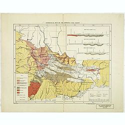
Geological map of the Donetz coal basin.
Uncommon American geological map of the Russian Donetz coal zone, published by R. Martens & Co. From New York. color key in lower left corner. The coal-field was disc...
Place & Date: New-York, ca. 1916
Selling price: $200
Sold in 2013
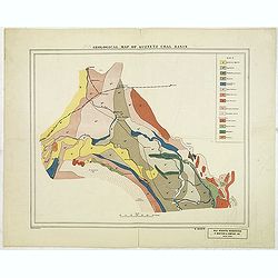
Geological map of Kuznetz coal basin.
American geological map of the Russian Kuznetsk Coal zone, published by R. Martens & Co. From New York. color key in upper The development of the coal fields of Kuzne...
Place & Date: New-York, ca. 1916
Selling price: $200
Sold in 2012
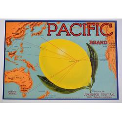
Pacific.
A color printed vintage 1917 Pacific Brand Lemon Crate Label, Packed by Johnston Fruit Company, Santa Barbara, California. This is an original crate label, not a copy.
Place & Date: Santa Barbara, 1917
Selling price: $22
Sold in 2019
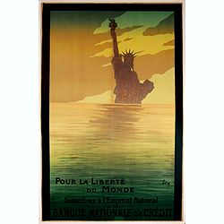
POUR LA LIBERTÉ DU MONDE, Souscrivez à l'Emprunt National, à la Banque Nationale de Crédit.
Advertising World War I poster for Banque Nationale de Crédit, made by Sem and printed by Impr. Devambez. The poster urges French citizens to purchase war bonds, “for ...
Place & Date: Paris, 1917
Selling price: $650
Sold in 2021

Vive la France !
The rare edition on Japan paper, only printed in 50 numbered examples. Hand signed in pencil, and numbered 49/50 in lower right margin (as well as in the plate, upper rig...
Place & Date: Paris, 1917
Selling price: $1550
Sold in 2020
Karte des Türkisch-ägyptischen Grenzgebietes. (Vorläufige Ausgabe) Blatt 3.
Centered on Suez, Great Bitter Lake and northern part of Suez Gulf and large part of the Sinai dessert during the World War I (1914-1918). Relief shown by hachures, gradi...
Place & Date: Berlin, 1917
Selling price: $500
Sold in 2018
![[Europe.]](/uploads/cache/82027-250x250.jpg)
[Europe.]
A very rare satirical map (postcard) showing Europe during first World War.
Place & Date: Marseille, 1918
Selling price: $100
Sold in 2020

(Military map as paper for stamps of the newly formed Latvia.) No. P. 17 Birze)
The first stamps of Latvia – printed on German military maps almost 100 years ago. Military map with red 5. Kap stamps - the rarer perforated and gummed version, showin...
Place & Date: Riga, Schnaekenburg printing, 1918-1919
Selling price: $210
Sold in 2012
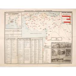
Instruction publique en Turquie.
Very rare separately published map of Turkey. In lower right insets of photo's of different schools, libraries and high schools in Istanbul. In upper left corner an inset...
Place & Date: Societe anonyme de Papeterie et d'Imprimerie, Constantinople, 1919
Selling price: $190
Sold in 2016
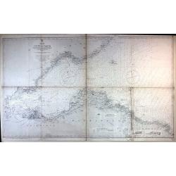
Firth of Forth, St. Abbs Head to the Forth Bridge (Maritimes Chart)
Fine large maritime chart featuring a segment of the Scottish east coast including Edinburgh, Haddington and Berwick.First published by the Admiralty in London in 1860. T...
Place & Date: London, 1919
Selling price: $2
Sold in 2015
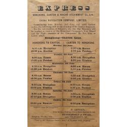
Express - Hongkong, Canton & Macao Steamboat Co., Ltd.
A very rare broadside: Express Hongkong, Canton & Macao Steamboat Co., Ltd. and China Navigation Company, Limited. With departure times of the boats. Printed in Hongk...
Place & Date: Hongkong, 1919
Selling price: $155
Sold in 2016
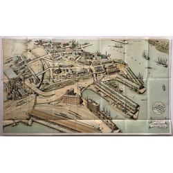
Sydney Harbour Trust, Birds eye view of Pyrmont - 1919.
A rare WW1 birds eye view of Pyrmont, Sydney Harbour.A wonderful, large lithographed view of the wharves at Pyrmont, Sydney Harbour by W. Withers, who was commissioned by...
Place & Date: Sydney, 1919
Selling price: $180
Sold in 2017
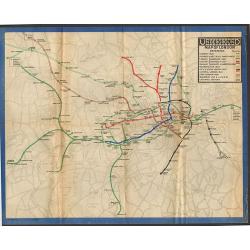
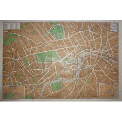
Underground Railway Map of London 1919.
One of the rarest London Underground maps. The first London Underground map produced after the end of World War One, the lines are shown with reasonable geographical accu...
Place & Date: London, 1919
Selling price: $260
Sold in 2018

Perfection de l'epiderme Pâte Agnel Beauté des mains.
Publicity for beauty cream by Leon Bonnote.
Place & Date: Paris, 1919
Selling price: $110
Sold in 2010

Latvijas Karte. . . Carte de la Latvie editée par le conseil national Latvien en Siberie.
One of the earliest maps showing an independent Latvia, in 1919. Estonia in upper right corner. Prepared by Luit. MantnieksOn July 21, 1919, Latvia and Estonia signed a b...
Place & Date: Latvia, 1919
Selling price: $275
Sold in 2017
![No title: [Minorca.]](/uploads/cache/16337-250x250.jpg)
No title: [Minorca.]
Geological map showing the island Minorca. Very interestingly in the lower right bottom manuscript notations in pencil with instructions for the editor, with P. Fallot's ...
Place & Date: Paris, c. 1920
Selling price: $300
Sold in 2018
![[Flag] Honor a los vaientes viva Espana.](/uploads/cache/23562-250x250.jpg)
[Flag] Honor a los vaientes viva Espana.
Place & Date: Spain, c.1920
Selling price: $200
Sold
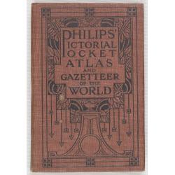
Philips' Pictorial Pocket Atlas and Gazeteer of the World.
A well-preserved copy of this charming little World-Atlas, not only interesting because of its clear maps and statistical diagrams, but also for its War Supplement. With ...
Place & Date: London, Philips, c.1920
Selling price: $100
Sold in 2010
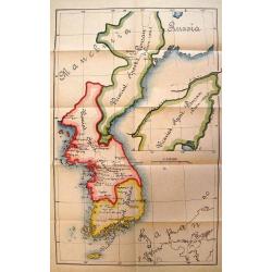
UNTITLED
Rare map of three Roman Catholic apostolic vicariates in Korea. The first of Korea was established in 1831 from the Diocese of Peking. In 1911, it was renamed the Apostol...
Place & Date: c. 1920
Selling price: $650
Sold in 2010

Welfare Map of Peiping.
Charming piece of early 20th century ephemera. This appeal of this tourist map of Beijing’s Tartar and Chinese cities is enhanced by the numerous cartoon vignettes foun...
Place & Date: Beijing, c. 1920
Selling price: $65
Sold in 2010

Stanford's Wall Map: Library Map of Africa, in 4 sheets.
Stanford's Library Map of Africa, constructed by A. K. Johnston. Scale, 94.34 miles= 1 inch, or 1: 5,977,382 of nature. Large wall map of the continent in four sheets. F...
Place & Date: London 1866, updated for 1920
Selling price: $1050
Sold in 2015

Map of Hong Kong and New Territories
An interesting map of Hong Kong and its Islands, showing main roads and railways, plus police stations and navigation lights.
Place & Date: London, 1920
Selling price: $425
Sold in 2016

Singapore.
Despite its small size it shows the city in great detail, with many street names, buildings, and places, etc. Includes the Raffles Hotel, the railway station, exchange, p...
Place & Date: London, ca. 1920
Selling price: $195
Sold in 2016

Prescription prepared at the Hong Kong Dispensary.
Unique old prescription in two parts by the Hong Kong Dispensary with handwritten text and instruction. The prescription with the nice seals. No written date given, but p...
Place & Date: Hongkong, probably ca.1920
Selling price: $31
Sold in 2016

Indo-Chine Française Saïgon - Cholon et ses Environs
Charming plan of Saïgon at a scale of 1:40.000. Vietnam was a French colony from 1862 to 1954.Prepared by R.Brissaud and published in P.Alinot, Petit Atlas de la Cochinc...
Place & Date: Saigon, Librairie Brunet. c.1920
Selling price: $200
Sold in 2020
![Indonesia & Malaysia [epherma].](/uploads/cache/81165-250x250.jpg)
Indonesia & Malaysia [epherma].
Three early papers of Hotel des Indes, British India Steamer Baggage label to Yangon, and a hotel in Penang.Hotel des Indes was one of the oldest and most prestigious hot...
Place & Date: Anon, ca. 1920
Selling price: $75
Sold in 2018
![[6 Post cards of young woman seated on a globe ]](/uploads/cache/41502-250x250.jpg)
[6 Post cards of young woman seated on a globe ]
Complete set of 6 pictorial post cards showing young women seated on a globe. Signed "Morin". Unsent.More aboutcartographical curiosities [+]
Place & Date: Italy, ca. 1920
Selling price: $130
Sold in 2018

Joan of Arc.
Showing a scene where Joan of Arc, holding her sword and in her typical haircut. She is being dressed up by two men, to her left several knights, one knight is holding th...
Place & Date: Paris (?), c.1890-1920
Selling price: $4500
Sold in 2019
![[Title in Ottoman Turkish: map of Africa].](/uploads/cache/44734-250x250.jpg)
[Title in Ottoman Turkish: map of Africa].
An uncommon Ottoman map of Africa. The continent is divided into different regions but no town names. In the lower left corner inset with title and key.Read more about th...
Place & Date: Ottoman Empire, ca. 1920
Selling price: $100
Sold in 2022

Vellum leaf with a large miniature showing saint surrounded by noble women in typical medieval dresses.
A large miniature (225x215mm) showing a scene with in the center a saint surrounded by medieval figures (Isabella of France and her son the future Edward III ?) descendin...
Place & Date: Paris (?), c.1890-1920
Selling price: $3000
Sold in 2022
![[No title - Blank title page]](/uploads/cache/48088-250x250.jpg)
[No title - Blank title page]
Beautiful blan title page set in an ornated border with illustrations by George Barbier, showing a couple kissing, with angels, in the middle might be Cupidon.
Place & Date: Paris, 1920
Selling price: $80
Sold in 2023

State of Arizona compiled chiefly from the official records of the General Land Office with supplemental data from other map making agencies, under the direction of I.P. Berthrong, chief of drafting division, G.L.O.
The map was compiled by Daniel P.O'Hare under the supervision of I. P. Berthrong, Drafting Division Chief of the General Land Office. It was printed by the Columbia Plano...
Place & Date: Washington D.C., 1921
Selling price: $100
Sold in 2015
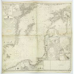
Baltic Sea Eastern SheetCompiled from Swedish German and Russian Government Surveys. . .
A large and detailed Admiralty chart first published in 1862, but with numerous revisions and editions up until 1921. Map of the Baltic Sea, covering some of the Gulf of ...
Place & Date: London, 1921
Selling price: $110
Sold in 2019
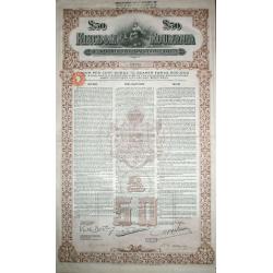
KINGDOM OF ROUMANIA £50 GOLD EXTERNAL LOAN 4% 1922 Bond.
KINGDOM OF ROUMANIA £50 GOLD EXTERNAL LOAN 4% 1922. No D1079. Large format with vignette of a girl with flowers.The verso is beautifully engraved. The main body of col...
Place & Date: London, 1922
Selling price: $85
Sold in 2016
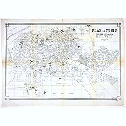
Plan de Tunis edité en 19éé par la librairie Yvorra & Barlier
A large plan of Tunis published by the Tunisian book shop and publisher Yvorra & Barlier.
Place & Date: Tunis, ca 1922
Selling price: $200
Sold in 2020

Carte de l''Indochine, feuille n°13: Bang-Kok.
Large scale map (1:500,000) centered on Bang Kok. Prepared by Lieutenant Colonel Dubuisson, head of the "Service Géographique de l'Indochine". With a color key...
Place & Date: Hanoï, 1923
Selling price: $200
Sold in 2013
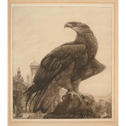
The Captive.
Superb impression, printed in dark brown ink, from the only edition of only 100 signed proofs. Printed by the artist himself. Signed in pencil bottom margin.The most impr...
Place & Date: London, 1923
Selling price: $220
Sold in 2014
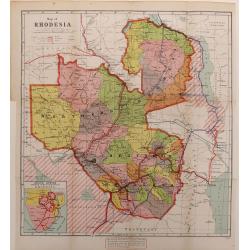
Map of Rhodesia.
A color-printed, wood engraved map of Rhodesia (now Zimbabwe), as administered by the British South Africa Company, which lasted from 1889 to 1924, when it became a Briti...
Place & Date: London, 1923
Selling price: $70
Sold in 2016
Clubland and Theatreland, London map 1924
This colorful and highly detailed large map of London was published c.1924 by Geographia Ltd. Covers the West End (Downtown) of London from the Hammersmith Bridge and Wor...
Place & Date: London, 1924
Selling price: $50
Sold in 2015

Erie Harbor and Presque Isle, Pennsylvania.
A US nautical chart of Erie Harbour and Presque Island in Pennsylvania - an eight updated edition (1924) to an original survey first undertaken in 1901 of the northern an...
Place & Date: United States, 1924
Selling price: $8
Sold in 2021
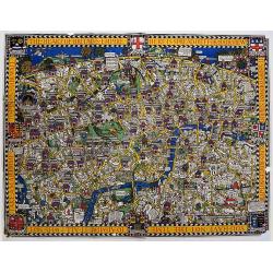
The Wonderground Map of London Town Drawn by MacDonald Gill.
In 1914, 'The Wonderground Map' was designed by MacDonald Gill and commissioned for the underground by Frank Pick, Commercial Manager of the then-Underground Electric Rai...
Place & Date: London, 1924
Selling price: $700
Sold in 2020

Burma
Curious large-scale map of Amherst & Thaton districts in Burma. Shows the area around Kamkareik with many place names, rivers, topographical features, etc. The Legend...
Place & Date: 1925
Selling price: $25
Sold in 2012

Plan commode deParis rues & monuments autobus & tramways - Guide indicateur des rues de Paris avec les stations du Métropolitain le plus proches. . .
A well-preserved copy of this charming folding map of Paris, in its original hardcover gilted red wrapper. This tourist map starts with a 162pp of index to the streets an...
Place & Date: Paris, ca. 1925
Selling price: $180
Sold
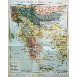
Teatro della guerra Greco-Turca.
Unusual map of South-East Europe with Greece, Romania, Bulgaria, and parts of Turkey. Coloring indicates the countries during the The Greco-Turkish War of 1919–1922. Pu...
Place & Date: Milan, c. 1925
Selling price: $100
Sold in 2017

Tetsudo kyoso Sugoroku [Railway Race Sugoroku)
A scarce Japan map produced ca. 1925 (Taisho 14) board for the Japanese game known as 'sugoroku'. The board depicts the islands of Japan oriented in a northwesterly direc...
Place & Date: Sogoroku-taisho14-1925
Selling price: $475
Sold in 2017

Ceylon.
A uncommon issue of this detailed map of Ceylon. Notes roads, railways, towns, rivers, lakes, and a host of other topographical features. Scale of 24 miles to an inch. Th...
Place & Date: Colombo, 1925
Selling price: $60
Sold in 2019

Ceylon.
A uncommon issue of this detailed map of Ceylon. The map covers the entire island and is color coded according to provinces. Notes roads, railways, towns, rivers, lakes, ...
Place & Date: Colombo, 1925
Selling price: $35
Sold in 2022

City of Colombo.
A uncommon issue of this detailed map of Colombo.The Department of Survey of Sri Lanka (also known as the Department of the Surveyor General) is a non-ministerial governm...
Place & Date: Colombo, 1925
Selling price: $50
Sold in 2019

(Publicity) Consommé P'ti'pot.
Original color lithographed, in-store small format, display for Consommé P'ti'pot designed Henry le Monnier and printed and published by the advertising agency and poste...
Place & Date: Paris, 1925
Selling price: $100
Sold
Côte Est d'Asie. Iles et Mers du Japon Mer Jaune.
Large French sea chart featuring the northern part of the Pacific Ocean and the Yellow Sea with Korea and Quelpaert Island, Japan and the coasts of Manchuria, and China t...
Place & Date: France, 1906-1925
Selling price: $500
Sold in 2020
Côte Est de Chine. Rivière de Wusung. Port de Shangaï.
Important French map featuring the harbour of Shanghai during the Chinese Revolution and the Civil War, and representing the French, English and American concessions. Ann...
Place & Date: France, 1905-1925
Selling price: $1800
Sold in 2018