Browse Listings
![[Untitled] Map of Northern India, Tibet, Nepal, Bhutan and surrounding countries.](/uploads/cache/42031-250x250.jpg)
[Untitled] Map of Northern India, Tibet, Nepal, Bhutan and surrounding countries.
The top sheet (No.47) of a two sheet map centered on Nepal, Bhutan and Tibet. Also covered by the map are: Northern India, Afghanistan, Pakistan, Turkistan, far Eastern C...
Place & Date: London, ca 1890
Selling price: $150
Sold in 2018

Carte de la Cochinchine.
Uncommon map of Cochin chine, prepared by captain Friquegnon. Printed in Hanoï by F.H.Schneider.
Place & Date: Hanoï, 1890
Selling price: $220
Sold in 2019

West Coast of Africa, Sheet III Sta. Cruz to Cape Bojador.
A large sea chart of an area of the north-western African coast from Santa Cruz to Cape Bojador, first surveyed in 1835 by Lieut. Arlett, R.N. The chart features depth so...
Place & Date: London, ca 1890
Selling price: $165
Sold in 2019
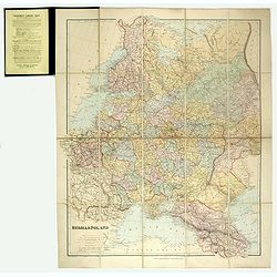
Russia & Poland.
Charming, folding map of Russia and Poland, giving a detailed overview of Europe from Baltic to Caspian Sea. Railways and rivers prominently delineated.In lower left a ke...
Place & Date: London, ca. 1890
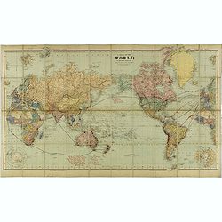
A Chart of the World on Mercator's Projection Shewing the Principal Ocean Steam Routes, the Submarine Telegraphs &c.
Charming, folding world map on Mercator's projection showing extensive steam routes and underground and undersea telegraph cables. The map is annotated in blue and red wi...
Place & Date: London, ca. 1890
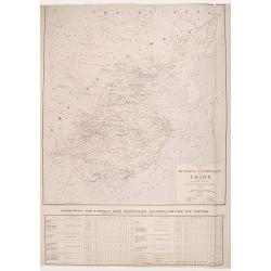
Carte des Missions Catholiques en Chine.
Uncommon and detailed map of China, Korea and Taiwan; includes also a description of the Catholics missions in China giving population and the number of missionaries, etc...
Place & Date: Lyon, 1890
Selling price: $375
Sold in 2008

Sketch Map of the Route of the Emin Pasha Relief Expedition
A complete extract from the Proceedings of the Royal Geographical Society of June 1890, p313 ? 331, with the folding map as called for on p.372, now bound in blue covers ...
Place & Date: London, 1890
Selling price: $360
Sold
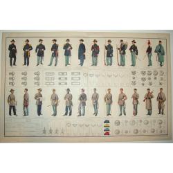
ATLAS TO ACCOMPANY THE OFFICIAL RECORDS OF THE UNION AND CONFEDERATE ARMIES 1861 - 1865
A highly desirable, rarely found double page lithograph of official Union and Confederate army uniforms, along with chevrons, buttons, badges, caps and more. A fascinatin...
Place & Date: New York, c. 1890
Selling price: $750
Sold

Neo-Gothic illuminated manuscript on vellum.
Wide panel border with designs of colored acanthusleaves on aburnished gold back ground. With a 8 lines verse in Latin.Blank verso.
Place & Date: Belgium, c. 1890
Selling price: $150
Sold in 2020

Nouvelle carte politique et commerciale de l'Europe indiquant toutes les communications maritimes, chemins de fer, et les changements des nouvelles limites des Etats d'Orient.
A large and very rare map of Europe, indicating various travelling routes. Decorated with 28 views of buildings and places in major cities such as Paris, Hamburg, Milan, ...
Place & Date: Paris, 1890
Selling price: $140
Sold in 2019

Goose game board inspired by Jules Verne's novel Tour du Monde en 80 jours.
Goose game board inspired by Jules Verne's novel whose boxes are illustrated with color lithographs and the center occupied by a world map. Vignette illustrations numbere...
Place & Date: Paris, ca. 1880-1890
Selling price: $750
Sold in 2021

Eastern Africa beteween the Rovuma and Zambesi rivers illustrating the surveys of Mr. J.T. Last.. . .
Map in two sheets of the eastern part of Africa. The Royal Geographical Society (with the Institute of British Geographers) is the Learned Society representing Geography ...
Place & Date: London, J.T Last, 1890
Selling price: $85
Sold in 2021

El Giro del Mondo.
Goos-game with 80 numbered anticlockwise boxes, showing a journey around the world. In center a steam ship and title. I four corners the rules of the game.In box 56 the P...
Place & Date: Milan, Stab. A.Bertarelli & C., 1890
Selling price: $110
Sold in 2020

Plan Phnom Penh et ses environs.
Early French map of Phnom Penh and its surroundings. Printed by. F. H. Schneider in Hanoi. Recruited as an agent at the colonial printing press in Saigon in 1882, he was ...
Place & Date: Hanoï, ca. 1890
Selling price: $120
Sold in 2020
Globo Celeste Arabio del Sec XI.
A 19th Century image of globe gores of an Arabic Celestial Globe. The Globe in the Museo Galileo in Florence is believed to be the oldest Arabic celestial globe in the wo...
Place & Date: Florence, 1891
Selling price: $200
Sold in 2020
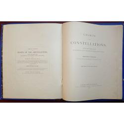
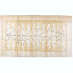
Charts of the Constellations, from the North Pole to between 35 & 40 Degrees of South Declination. Popular Edition, on a Reduced Scale With Three Additional key Maps and Introduction and Notes.
All 39 celestial charts are present plus the introduction of 32 pages. Published by Edward Stanford.Additional shipping costs apply due to weight of the book. Shipping to...
Place & Date: London, 1891
Selling price: $230
Sold in 2019
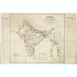
India. To illustrate the goods traffic on Indian ralways . . .
Large folded map of India, Ceylon, Malaysia, illustrating the goods traffic on Indian railways for the year 1891. A small inset showing the continuation until Singapore.T...
Place & Date: London, 1891
Selling price: $85
Sold in 2017
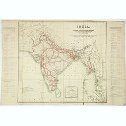
India. To illustrate the passengers traffic on India railways, showing the average number of passengers carried per mile over the various sections of each line, during the year 1891 . . .
Large folded map of India, Ceylon, Malaysia, showing the traffic of passengers by train for the year 1891. A small inset showing the continuation until Singapore.Text pan...
Place & Date: London, 1891
Selling price: $85
Sold in 2017

India. To illustrate the principal centres of traffic on Indian railways.
Large folded map of India, Ceylon, Malaysia, illustrating the principal centres of traffic on Indian railways for the year 1891.Text panels to the side : "Principal ...
Place & Date: London, 1891
Selling price: $85
Sold in 2017
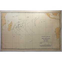
Cyclone tracks in the South Indian Ocean, December 1848-1885.
A map of the tracks of cyclones recorded in December for the years 1848 to 1885, except for years 1849, 1850 and 1853, published in London. Printed for H.M.S.O. by Eyre a...
Place & Date: London, 1891
Selling price: $12
Sold in 2018
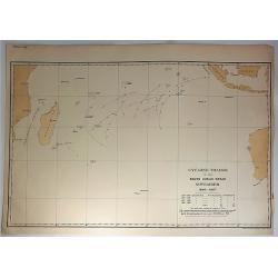
Cyclone Tracks in the South Indian Ocean, November 1848-1885.
A map of the tracks of cyclones recorded in November for the years 1848 to 1885, except for years 1849, 1850 and 1853, published in London. Printed for H.M.S.O. by Eyre a...
Place & Date: London, 1891
Selling price: $11
Sold in 2018
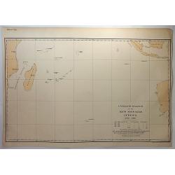
Cyclone tracks in the South Indian Ocean, October 1848-1885.
A map of the tracks of cyclones recorded in October for the years 1848 to 1885, except for years 1849, 1850 and 1853, published in London. Printed for H.M.S.O. by Eyre an...
Place & Date: London, 1891
Selling price: $10
Sold in 2018
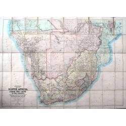
Juta's Map of South Africa from the Cape to the Zambesi...
A large and detailed folding-map of Southern Africa, published by Juta in Cape Town and Standford in London. With regions of the time such as Gaza Land, Orange Free State...
Place & Date: Cape Town (London), 1891
Selling price: $145
Sold in 2019

Vue de Hong Kong
This is a wonderful antique print depicting a panoramic view of Hong Kong as it appeared in the late-1800s. Wood engraving, published in l'Univers illustré. French text ...
Place & Date: Paris, ca. 1891
Selling price: $165
Sold
![Canada Creek Falls . . [title in French, English, German & Latin] N°32. Pl. 4.](/uploads/cache/26800-250x250.jpg)
Canada Creek Falls . . [title in French, English, German & Latin] N°32. Pl. 4.
A view of the Canada Creek Falls.From 8e Livraison Amérique Septentrionale - Etat de New York. After Jacques Milbert and lithographed by Dupressoir and figures by V. Ada...
Place & Date: Paris, Bove dirigée par Nöel ainé & Cie, 1892
![Albany-Capital of the State of New York. . . [title in French, English, German & Latin] N°13. Pl. 1.](/uploads/cache/26654-250x250.jpg)
Albany-Capital of the State of New York. . . [title in French, English, German & Latin] N°13. Pl. 1.
A town-view coastal of Albany-Capital of the State of New York..From 4e Livraison Amérique Septentrionale - Etat de New York. After Jacques Milbert and lithographed by D...
Place & Date: Paris, Bove dirigée par Nöel ainé & Cie, 1892
Selling price: $750
Sold in 2010
![Foundery on Jone's Creek near Baltimore. . [title in French, English, German & Latin] N°52. Pl. 4.](/uploads/cache/26804-250x250.jpg)
Foundery on Jone's Creek near Baltimore. . [title in French, English, German & Latin] N°52. Pl. 4.
A view of Jone's Creek foundery near Baltimore.From 13e Livraison Amérique Septentrionale - Etat de New York. After Jacques Milbert and lithographed by Bichebois and fig...
Place & Date: Paris, Bove dirigée par Nöel ainé & Cie, 1892
Selling price: $100
Sold in 2009
![Commencement of Passaic falls. . [title in French, English, German & Latin] N°47. Pl. 3.](/uploads/cache/26818-250x250.jpg)
Commencement of Passaic falls. . [title in French, English, German & Latin] N°47. Pl. 3.
A view of the Passaic Falls.From 12e Livraison Amérique Septentrionale - Etat de New York. Drawn after nature by J.R.Smith and lithographed by Dupressoir and the figures...
Place & Date: Paris, Bove dirigée par Nöel ainé & Cie, 1892
Selling price: $100
Sold in 2009
![View of the natural bridge. [title in French, English, German & Latin] N°53. Pl. 5.](/uploads/cache/26819-250x250.jpg)
View of the natural bridge. [title in French, English, German & Latin] N°53. Pl. 5.
A view of a natural bridge.From 13e Livraison Amérique Septentrionale - Etat de New York. After Jacques Milbert and lithographed by Bichebois and figures by V. Adam. Pri...
Place & Date: Paris, Bove dirigée par Nöel ainé & Cie, 1892
Selling price: $80
Sold in 2009

Saw-Mill at the village of Glenns. . . N°23. Pl.3.
A view of the saw mill at the village of Gleens.From 6e Livraison Amérique Septentrionale - Etat de New York. After Jacques Milbert and lithographed by Villeneuve. Print...
Place & Date: Paris, Bove dirigée par Nöel ainé & Cie, 1892
Selling price: $225
Sold in 2010

Australland.
Detailed map of Australia. With index to the different, colonies, with number of inhabitants and size. Border lines are drawn in by hand.A interesting map by the famous G...
Place & Date: Glogau, 1892
Selling price: $150
Sold in 2020
La quadratura nel circolo ossia il giuoco delle alleanze.
Circular game of alliances in Europe depicting 18 European countries personified by characters in costume and in the center, St Peter's Square in Rome. Text in 2 columns ...
Place & Date: Turino, ca. 1892
Selling price: $140
Sold in 2020

Grand Birds-Eye View of the Grounds and Buildings of the Great Columbian Exposition at Chicago, Illinois, 1892-3.
Lithography after a watercolor by C. Graham created as part of a portfolio for the World's Columbian Exposition (also known as the Chicago World's Fair) was a world's fai...
Place & Date: New York, 1892
Selling price: $1200
Sold in 2023
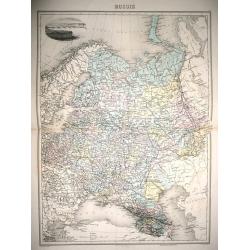
Russie.
Full inscriptions: Russie. Grave par L. Smith. Dresse Sous La Direction De J. Migeon Par Ch. Lacoste. Migeon, editeur, imp, r. du Moulin Vert, Paris. Ecrit par A. Bizet. ...
Place & Date: Paris, 1892
Selling price: $60
Sold in 2014
Africa east coast Malindi to Juba Surveyed by Captain ... W. F. W. Owen,1824-25... Surveying ship,
A fine Hydrographic Office chart no. 848 (2245), showing the coast from Malindi to Juba (Kenya). Engraved by Davies & Company. London : Published at the Admiralty 14t...
Place & Date: London, 1877 / 1892
Selling price: $80
Sold in 2019
The Universal Atlas published for The Atlas Publishing Company .
Published in London by Cassell and Company Ltd, London, Paris & Melbourne in 1893. A highly detailed Atlas of the World, in a folio size - illustrated with 117 colore...
Place & Date: London, 1893
Selling price: $160
Sold in 2016
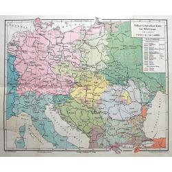
Völker-u. Sprachen-Karte von Mitteleuropa.
Interesting thematic map illustrating the nations and languages of central Europe, from Brussels to the Black Sea. Published by Artaria in Vienna.
Place & Date: Vienna, 1893
Selling price: $20
Sold in 2016
![[Title in Chinese - General map of China]](/uploads/cache/42891-250x250.jpg)
[Title in Chinese - General map of China]
Chromo lithographed map of China prepared by Pêre S. Chevalier and published by Hong-pao-tchai, Shanghai. With 3 colored insets and several index and key tables. The tit...
Place & Date: Shanghai / Zi-ka-wei, 1893
Selling price: $2400
Sold in 2018

Panorama vom Gornergrat.
The Gornergrat is situated in Switzerland, between the Gornergletscher and Findelgletscher and offers views of more than 20 four-thousand metre peaks, whose highest are t...
Place & Date: London, ca 1893
Selling price: $45
Sold in 2019
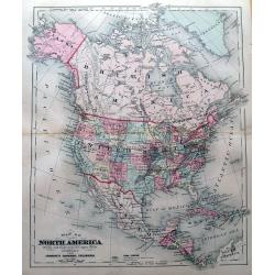
Map of North America.
Attractive map of North America during the late 19th century. With the Indian Territory north of Texas. Indicates coal fields, and shows railways.
Place & Date: New York, 1894
Selling price: $25
Sold in 2015

A set of 23 humorous Punch prints of Russian interest and The Crimea, The Russian Empire's war with the French and British Empire's. 1853 - 1894
This set of 23 prints are from 1853 - 1894. Mostly engraved by Joseph Swain. Joseph Swain was one of the most important woodblock engravers. Punch was responsible for the...
Place & Date: London, 1853 – 1894
Selling price: $100
Sold in 2016
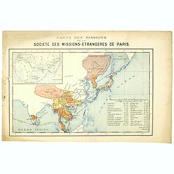
Carte des missions de la société des missions-étrangeres de Paris.
Rare and detailed map of the Far East, including India, Thailand, China, Tibet, Korea, Japan. Key to Missions confiées à la Société des Missions Etrangères avec le c...
Place & Date: Lyon / Paris, 1894
Selling price: $150
Sold in 2020

Express. Queen's Road Echoes.
Rare broadside with critical and political text about the Tai Ping Shan area. Printed in Hongkong, dated 21st July 1894.
Place & Date: Hongkong, 1894
Selling price: $31
Sold in 2016
Tape Indicator Map of London and Visitors Guide.
A fold out linen backed hand colored plan of London by Charles Smith & Son, London, 1894. With green hardcover in good condition. Tape is present and complete.
Place & Date: London, 1894
Selling price: $120
Sold in 2017
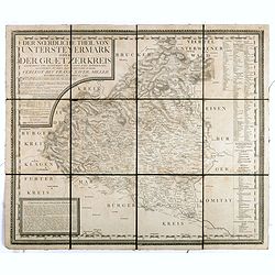
Der noerdliche Theil von Untersteyermark oder der Graetzer Kreis, Entworfen und gezeichnet von Joseph Karl Kindermann
Beautiful, rare and decorative copper engraved map of Styria, Austria. Prepared by Jos. Karl Kindermann, engraved by Christoph Junker in Vienna and published by Xavier Mi...
Place & Date: Graetz, 1789-1894
Selling price: $55
Sold in 2018

Burma and adjacent countries.
A large color printed map of Burma and her neighboring countries.
Place & Date: London, 1894
Selling price: $50
Sold in 2018
ATLAS TO ACCOMPANY THE OFFICIAL RECORDS OF THE UNION AND CONFEDERATE ARMIES, 1861-1865
An impressive and rarely seen double-page lithographic print of official U.S. Civil War-era national and military standards, badges, and icons. More than 100 items are de...
Place & Date: New York, ca. 1894
Selling price: $325
Sold
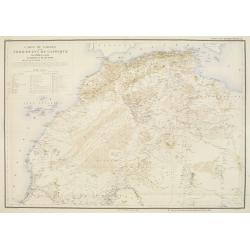
Carte du Sahara et du Nord Ouest de l'Afrique.
Rare and detailed map of northern part of Africa, including Canary Islands. Includes also a translations of some basic words in Arab and Berber. Key to Lieux ou ont été...
Place & Date: Lyon/Paris, 1894
Selling price: $260
Sold
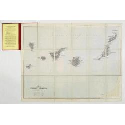
Map of the Canary Islands.
Charming folding map of Canary Islands, still in it's original publisher's yellow advertisements at endpapers, folding into original red covers, yellow label. Published b...
Place & Date: London, ca. 1894
Selling price: $150
Sold
Chine - Détroit de Petchily. Lu Chun Ko ou Port Arthur.
Detailed of Lushan or Port Arthur.In 1856, during the Second Opium (or Arrow) War, an English captain, Lieutenant William C. Arthur, towed a damaged English gunboat into...
Place & Date: Paris, 1885 updated for 1894
Selling price: $150
Sold in 2013

Etats Danubiens. . .
Map of east of Europe, showing Hongriae, Serbia, Bulgaria, Romania, Bosnia and part of the Black Sea up to Odessa. Text in French in lower part.This publication is in fac...
Place & Date: Paris, E.Capiomont,1894
Selling price: $100
Sold in 2014
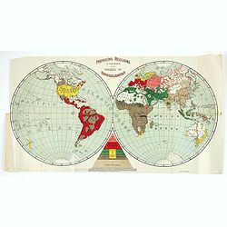
Prevailing Religions of the World and Progress of Evangelization.
Baker and Taylor Map of the World's Religions. Uncommon persuasive map illustrating the global progress of Christian evangelization.A curious 1894 map of the world that a...
Place & Date: Philadelphia, 1894
Selling price: $100
Sold in 2021

Valparaiso und Santiago.
Eye-bird view of Valparaiso bay, together with a city plan of Santiago. The print has been printed by F.A.Brockhaus Geogr. - artist. Anstalt, Germany in 1895.
Place & Date: Germany, 1895
Selling price: $25
Sold in 2020

A set of 10 humorous prints with China interest.
This set of 10 are from 1857 - 1895. Mostly engraved by Joseph Swain. Joseph Swain was one of the most important woodblock engravers.Punch was responsible for the word se...
Place & Date: London 1857 - 1895
Selling price: $80
Sold in 2015
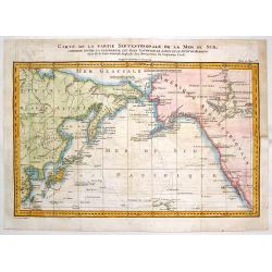
Carte de la Partie Septentrionale de la Mer du Sud, Comprise entre La Californie, Les Isles Sandwich, Le Japon et le Detroit de Behring
An informative Cook's map of the Pacific Ocean with the Behring Straight and Hawaii featured. It shows the route of Captain Cook's 3rd voyage between 1778 and 1789. Lieut...
Place & Date: Paris, ca. 1895
Selling price: $26
Sold in 2018
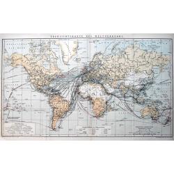
Übersichtskarte des Weltverkehrs.
Interesting map of the World showing the shipping routes between the major ports, with the duration of traveling. Published around 1895 the map shows numerous colonial po...
Place & Date: Leipzig, c1895
Selling price: $33
Sold in 2013
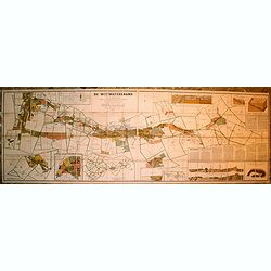
Carte Du District Aurifere Du Witwatersrand Transvaal (Afrique du Sud) Par S. Goldmann d'apres le Cadastre officiel du Gouvernement
VERY RARE OCLC lists one copy at the Bibl. Interuniversitaire Scientifique Jussieu (Paris) and one copy on the trade.Mineralogical survey dating from the early years of t...
Place & Date: (Johannesburg, Decembre 1894 / Paris, 1895
Selling price: $1401
Sold in 2019

Philippine Islands.
Nice chromolithograph map of the Philippines, extending from the Bashee Channel and the southern tip of Formosa and Hong Kong to North Borneo and the Celebes Sea. Include...
Place & Date: Chicago, 1895
Selling price: $95
Sold in 2017

Le Petit Journal - Uniforme des armées Européennes.
French wall map sized map of Europe taken from the famous newspaper Le Petit Journal Illustré, showing the different army uniforms types in Europe, with a map of Europe....
Place & Date: Paris, circa 1895
Selling price: $300
Sold in 2017
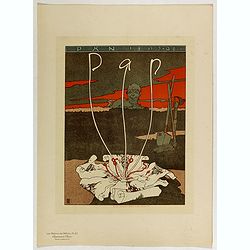
Pan.
Chromo lithographed poster, "Pan.", by SATTLER, J. Plate 67, published in Maître 17, on April 1895. The "Les Maîtres de l'Affiche" contained 256 sma...
Place & Date: Paris, Imprimerie Chaix, April 1895
Selling price: $120
Sold
Les Mines d'Or de l'Afrique du Sud. Deuxieme edition considerablement augmentee.
An important work in French on gold and gold mining in South Africa, written shortly following the discovery of gold in the Witwatersrand in 1886, a profound transition f...
Place & Date: Paris, Lemaire & Dupont, 1895
Selling price: $100
Sold in 2018

Bird's Eye View of the Tourists' Ideal Route from Niagara to the Sea.
A terrific "bird's eye view" of the Tourists' Ideal Route from Niagara to the Sea - ca. 1895. The maker is unknown, map shows from Nova Scotia to St Louis, and ...
Place & Date: Buffalo, ca. 1895
Selling price: $105
Sold in 2018

Korea, eine Sommerreise nach dem Lande der Morgenruhe, 1894
Hesse-Wartegg arrived in Busan from Nagasaki, and travelled in the South of Korea to Seoul. Chapters on the Emperor and his government, soldiers, calendar, ceremonies, re...
Place & Date: Dresde, Leipzig, Carl Reissner, 1895
Selling price: $475
Sold in 2018
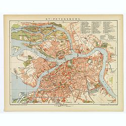
St. Petersburg.
A lovely detailed double page plan of the famous Russian city of St. Petersburg. From 'Brockhaus' Konversations-Lexikon', published by F. A. Brockhaus, in Leipzig. A num...
Place & Date: Leipzig, 1895
Selling price: $35
Sold in 2018
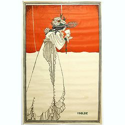
Isolde.
Lithographed poster signed Isolde by Aubrey Beardsley in the Art Nouveau manner. Printed by Gallery five. In the tales of King Arthur, the knight Tristan and the Irish pr...
Place & Date: London, 1895
Selling price: $350
Sold
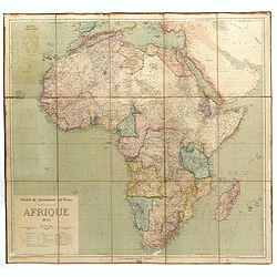
Afrique.
Oversized and detailed map of Africa drawn by J. Hansen and engraved by Erbard Freres (Paris), with part of Arabia and Madagascar. Published by E.Andriveau-Goujon.
Place & Date: Paris, 1895
Selling price: $205
Sold in 2019

Port de Boston d'après la carte de l'United Coast Survey.
A fine French Service Hydrograhique de la Marine chart no. 4821, showing Boston Harbour, after maps of the United Coast Survey. A past-on (7 x 10 cm) has been pasted on t...
Place & Date: Paris, 1895
Selling price: $150
Sold in 2019

Japan - The Kuril Islands from Nipon to Kamchatka..
Large chart representing the Kuril Islands in the Pacific Ocean. Some of the capes and bays are highlighted in red and yellow.Contains 7 inset plans of bays, anchorages a...
Place & Date: London, 1893, updated 1895
Selling price: $150
Sold in 2021
![[Title in Ottoman Turkish: WEST AFRICA AND THE MAGHREB].](/uploads/cache/44731-250x250.jpg)
[Title in Ottoman Turkish: WEST AFRICA AND THE MAGHREB].
A fine Ottoman map of West Africa and the Maghreb from Ali Seref Pasa’s rare ‘Yeni cografya atlasi’, published by the press of Matbaa-i Amire, the successor of Ibra...
Place & Date: Beyazit, Istanbul: Matbaa-i Amire 1311 or 1895
Selling price: $250
Sold in 2019

Map of New York City showing portions of Brooklyn, Jersey City, and Westchester Co.
Map of the routes of the train system around New York. With inset plan of lower Manhattan. On verso Guide map of New York City, with lovely illustration of Broadway Centr...
Place & Date: Chicago & New York, 1895
Selling price: $50
Sold
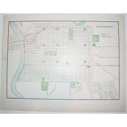
Sacramento.
A nice, late 19th century plan of the City of Sacramento, capital of California. The map shows the city's existing railway as well as the "proposed railway". On...
Place & Date: New York, ca. 1895
Selling price: $40
Sold

Carte de L'Indo-Chine Dressée sous les auspices des Ministres des affaires étrangéres & des colonies..
Large folding, so-called case-map showing Indo China and part of Thailand.Printed in color lithography by Dufrénov in Paris. The map is engraved on stone by Poulmaire.Wi...
Place & Date: Paris, 1895
Selling price: $450
Sold

Map of Switzerland.
Rand McNally & Company. Indexed Atlas of the World.The name Rand McNally is today synonymous with maps, and Rand McNally & Company is one of the foremost cartog...
Place & Date: Chicago, 1895
Selling price: $25
Sold in 2010

Map of Sweden and Norway.
Rand McNally & Company. Indexed Atlas of the World. The name Rand McNally is today synonymous with maps, and Rand McNally & Company is one of the foremost cart...
Place & Date: Chicago, 1895
Selling price: $10
Sold in 2010

Philippine Islands.
Map of the Philippines, with insets of Manila, Manila vicinity, Sulu Archipelago, China Sea and Batan Islands. The shipping routes between the main cities are printed in ...
Place & Date: Chicago & New York, 1895
Selling price: $300
Sold in 2014

Paris fashion plate. (3248)
Uncommon Paris fashion plate from Le Moniteur de la Mode, under direction of Abel Goubaud.In the later quarter of the 19th century there was a proliferation of women's ma...
Place & Date: Paris, 1896
Selling price: $3
Sold in 2023

Paris fashion plate. (3281)
Uncommon Paris fashion plate from Le Moniteur de la Mode, under direction of Abel Goubaud.In the later quarter of the 19th century there was a proliferation of women's ma...
Place & Date: Paris 1896
Selling price: $30
Sold in 2011
Atlas international des nuages. International cloud-atlas. Internationaler wolken-atlas.
FIRST EDITION. Title in French, English and German. The first edition consisted of plates of color photographs, which was then a new technology."In 1874, the year of...
Place & Date: Paris, Gauthier-Villars et fils, 1896
Selling price: $2400
Sold
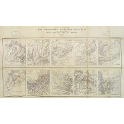
Carte d'Ensemble des Principaux Districts Aurifères (autre que le district aurifère de Witwatersrand) situés dans les pays Sud africains.
Ten inset maps of the main auriferous districts located in various South African countries. A key in upper left and right hand corner. The places with gold mines are indi...
Place & Date: Paris, Monroqo, 1896
Selling price: $190
Sold in 2010
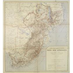
Carte Commerciale et Minière Pays Sud-Africains.
General trade and gold mine map of South Africa.In upper right corner "Carte Commerciale et Minière des Pays Sud-Africains No. 1".Prepared by F. Bianconi. With...
Place & Date: Paris, Monroqo, 1896
Selling price: $180
Sold in 2010