Browse Listings
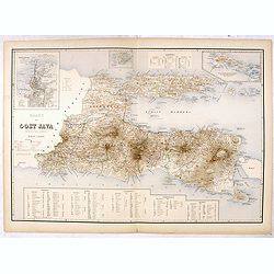
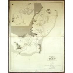
Kaart van Oost Java. (derde militaire afdeeling.)
Very detailed map of East Java taken from "Atlas der Nederlandsche bezittingen in Oost-Indië", who was published by Departement van Koloniën". With large...
Place & Date: The Hague, 1883-1885
Selling price: $50
Sold in 2016
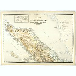
Kaart van Noord Sumatra: Gouvernement Atjeh en Onderhoorigheeden / Noordelijke gedeelten van de Res.n Tapanoeli en Sumatra's Oostkust / en de onafhankelijkeBatak Landen. . .
Very detailed map of Northen Sumatra, taken from "Atlas der Nederlandsche bezittingen in Oost-Indië", who was published by Departement van Koloniën".Firs...
Place & Date: The Hague, 1883-1885
Selling price: $50
Sold in 2023
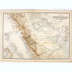
Kaart van Midden-Sumatra : Gouver.nt v. Sumatra's Westkust, Zuid ged. d. R. Sumatra's-Oostkust, Afd. Lingga v.d. Res. Riouw en Onderh. en het Rijk Djambi.
Very detailed map of Central Sumatra, taken from "Atlas der Nederlandsche bezittingen in Oost-Indië", who was published by Departement van Koloniën". Wit...
Place & Date: The Hague, 1883-1885
Selling price: $55
Sold in 2017
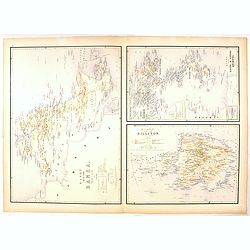
Kaart van Eiland Banka / Kaart van den Riouw en Lingga Archipels / Kaart van het Eiland Billiton.
Three very detailed maps of Banka Island, Billiton and the Riouw and Lingga Archipel, taken from "Atlas der Nederlandsche bezittingen in Oost-Indië", who was p...
Place & Date: The Hague, 1883-1885
Selling price: $40
Sold in 2016
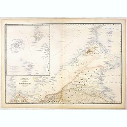
Kaart van Het Noordelijk Gedeelte Van Het Eiland Borneo.
Very detailed map of Northern Borneo, taken from "Atlas der Nederlandsche bezittingen in Oost-Indië", who was published by Departement van Koloniën".With...
Place & Date: The Hague, 1883-1885
Selling price: $125
Sold in 2016
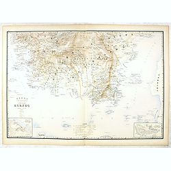
Kaart van het Zuidelijk Gedeelte Van het Eiland Borneo.
Very detailed map of Southern part of Bornea, taken from "Atlas der Nederlandsche bezittingen in Oost-Indië", who was published by Departement van Koloniën&qu...
Place & Date: The Hague, 1883-1885
Selling price: $40
Sold in 2020
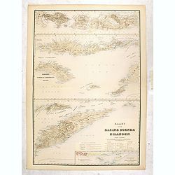
Kaart van de Kleine Soenda Eilanden.
Four very detailed maps of the Soenda Islands on one sheet taken from "Atlas der Nederlandsche bezittingen in Oost-Indië", who was published by Departement van...
Place & Date: The Hague, 1883-1885
Selling price: $50
Sold in 2016
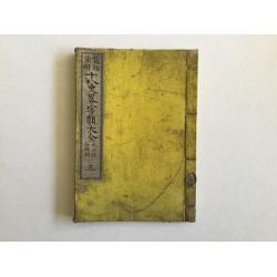
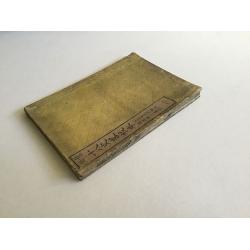
Ju Hachi Shiryaku - Summaries of the 18 eras, Historical maps.
A superb atlas of Chinese maps, showing the geographic extent of various Chinese dynasties.11 beautifully hand colored double page woodblock maps of China. Publisher: Moh...
Place & Date: 1885
Selling price: $210
Sold in 2016
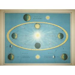
The Seasons, The Earth and the Moon
An attractive engraving showing the Four seasons, and the Moon's attraction to the sun.
Place & Date: London, 1885
Selling price: $85
Sold in 2016
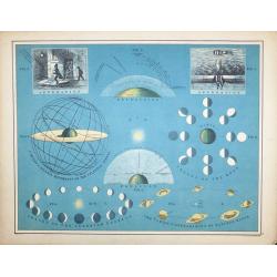
Circles & Diurnal Movements of the Celestial Sphere
An attractive celestial engraving showing various phases of the planets.
Place & Date: London, 1885
Selling price: $120
Sold in 2016
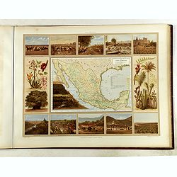
Atlas pintoresco e histórico de los Estados Unidos Mexicanos.
Monumental atlas solely devoted to Mexico, very rare to find complete and in very good condition.This atlas is regarded as one of the most beautiful color-plate books on ...
Place & Date: Mexico City, sucesores de Debray, 1885
Selling price: $5700
Sold
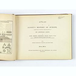
Alison's History of Europe.
An atlas with frontispiece, 108 battle and siege plans and maps, with 16 pp. lithographic explanation of Military Signs and Illustrations of Modern Fortification.Quarto s...
Place & Date: Edinburgh, London, 1885
Selling price: $115
Sold in 2018

Wandkarte der Alpen nach dem Entwurfe & unter der Leitung des Vinzenz von Haardt ausgeführt in Ed. Holzel's geographischem Institut in Wien...
Large folding map of French and Swiss Alps. Hölzels' masterpiece of cartography, edited by Vincent von Haardt. Eduard Hölzel opened in 1844 a bookstore in Olomouc (now...
Place & Date: Vienna, 1885
Selling price: $500
Sold in 2019

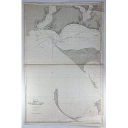
Chine. Côte Nord de Formose. Baye de Ke-Lung..
Large illustrating the bay of Keelung in Taiwan.Showing settlements, banks, isles and soundings made in metres. Relief shown by hachures.Prepared in 1884 by M.M. Renaud ...
Place & Date: Paris, 1886
Selling price: $750
Sold in 2020

Captain James Cook portrait with facsimile signature
'CAPTAIN JAMES COOK' with a facsimile signature. Exceptional engraved portrait of a fine naval man.Original steel engraving by Henry Bryan Hall, and his three sons; Henry...
Place & Date: New York, ca. 1886
Selling price: $95
Sold in 2016
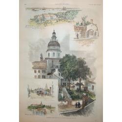
Annapolis, Maryland
A beautiful woodcut grouping incorporating five views of / in Annapolis, the capital of Maryland. The central view is of the old capitol building. The original U.S. Naval...
Place & Date: New York, 1886
Selling price: $100
Sold

Cyprus. / London Atlas map of Cyprus.
With decorative cover title: LONDON ATLAS MAP OF CYPRUS. LONDON EDWARD STANFORD Ltd. Cartographer to the King, / 12, 13 & 14, LONG ACRE, W.C. and 29 & 30 Charing ...
Place & Date: London, 1887
Selling price: $350
Sold in 2009
Mer de Chine. Golfe du Tonkin. Entrées de Kuaï-Chin-Mun et Tsieng-Mun. . .
Large chart centred on the Gulf of Tonkin in the South China Sea. Showing banks, isles and soundings made in metres. Relief is shown by hachures.Engraved by A. Gérin aft...
Place & Date: Paris, 1887
Selling price: $300
Sold in 2008

East India Arichpelago (Miyako + Oki Daito Islands)
Very large sea-chart showing the Japanese Islands Miyako-jima (here still called Typinsan) and Okidaitō (Rasa Island). The huge sheet mainly covers water, only ...
Place & Date: London, 1887
Selling price: $30
Sold in 2012

Carte des rcifs Arbrohos (Cote du Bresil).
Large detailed marine chart of the coast of Brazil from San Mateo to the Itacolomis. The cost of the chart was printed on the map and was two francs. Depot de la Marine...
Place & Date: Paris, 1887
Selling price: $95
Sold in 2015

CEYLON
A fine detailed map of Ceylon with the provinces colored in separate tints. The districts are separated by narrow red lines and their names underlined in red A railway ru...
Place & Date: London, 1887
Selling price: $50
Sold in 2014
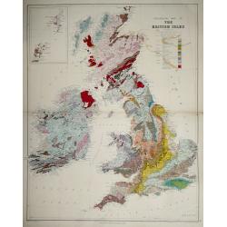
Geological map of the British Isles.
Geological map of the British Isles by Edward Best, published by Edward Stanford. Steel engraved.Shows 27 geologic units. Includes inset of the Shetland and Orkney islan...
Place & Date: London, 1887
Selling price: $60
Sold in 2014
Sheet 2 (Western Route to China).
Impressively sized sea-chart of a part of the Java Sea. Shows Indramayu to Semarang on Java, the Karimunjawa Islands, a small part of Borneo, and a part of Belitung (Bill...
Place & Date: London, 1887
Selling price: $120
Sold in 2014
ILE UVEA CROQUIS DES BAIES DE MUA ET DE MATA UTU.
Mata-Utu is the capital of Wallis and Futuna, an overseas collectivity of France. It is located on the island of Uvéa, in the district of Hahake, of which it is also the...
Place & Date: Paris, 1887
Selling price: $16
Sold in 2018
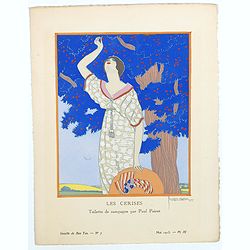
Les cerises.
Beautiful pochoir taken from the "Gazette du Bon Ton" signed by Le Pape. Plate N°7 from May 1913. La Gazette du Bon Ton is a luxury fashion magazine published ...
Place & Date: Paris, 1887
Selling price: $200
Sold in 2017
Mer Noire - Entrée du Liman du Dnieper et Baie de Tendra.
A fine large sea chart on the Black Sea in the Ukraine featuring the Dnieper River and the Tendra Bay. It has an insert of Liman de Berezan and shows Kinburn Spit and Ca...
Place & Date: Paris, 1887
Selling price: $17
Sold in 2018
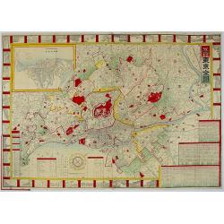
Map of Tokyo.
A very attractive folded engraved map of Tokyo in the Japanese and English languages in woodblock color. It shows views of tourist attractions. It includes an address cha...
Place & Date: Tokyo, 1887
Selling price: $250
Sold in 2018
![[Atlas] Report of the Royal Commission on The Land Law (Ireland) Act, 1881, & The Purchase of Land (Ireland) Act, 1885,](/uploads/cache/43202-250x250.jpg)
[Atlas] Report of the Royal Commission on The Land Law (Ireland) Act, 1881, & The Purchase of Land (Ireland) Act, 1885,
The Land Acts were a series of measures to deal with the question of peasant proprietorship of land in Ireland in the nineteenth and twentieth centuries. Five such acts w...
Place & Date: London, 1887
Selling price: $100
Sold in 2019

Murphy Bolanz. Official Map of the City of Dallas and East Dallas, Texas, 1887.
Engraved map with to the right and lower margin. Very small inset map of northeast Texas at top, along with an illustration of the firm's offices. Size of the map 375x252...
Place & Date: Dallas, June, 1888
Selling price: $1150
Sold in 2014

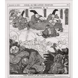
A set of 20 humorous prints of Russian interest and The Crimea, The Russian Empire's war with the French and British Empire's. 1849 - 1888 London 1849 - 1888
This set of 20 are from 1849 - 1888. Mostly engraved by Joseph Swain. Joseph Swain was one of the most important woodblock engravers. Punch was responsible for the word s...
Place & Date: London, 1849 - 1888
Selling price: $120
Sold in 2016
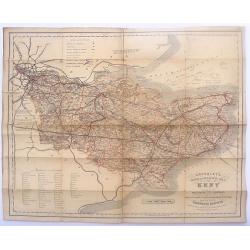
Cruchley's Road and Railway Maps of the County of Kent.
Interesting map featuring the roads and rail lines in the English county of Kent. It also shows the names of the stations, turnpike roads, villages, gentlemen's seats, im...
Place & Date: London, 1888
Selling price: $15
Sold in 2016
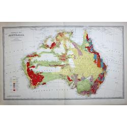
GEOLOGICAL MAP OF AUSTRALIA
The best colonial period geological map of Australia. The map has a color index to the lower left quadrant. This rare map is from the 'Picturesque Atlas of Australasia', ...
Place & Date: Melbourne, 1888
Selling price: $350
Sold in 2017
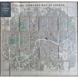
Collins Standard Map of London.
Linen backed. A famous map of London, drawn by Richard Jarman in 1858, at a scale of four inches to one statute mile, and originally published by Henry George Collins. W...
Place & Date: London, 1888
Selling price: $200
Sold in 2018
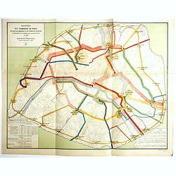
Recettes des tramways de Paris des bateaux-omnibus et du chemin de ceinture et mouvements des voyageurs dans les gares de paris en 1880.
Detailed plan of Paris showing the movements of passengers between the different stations in the year 1880. Legends in the lower right and left corners, including the num...
Place & Date: Paris, Monrocq, 1888
Selling price: $450
Sold in 2018
![East India archipelago [Western route to China, chart No. 6].](/uploads/cache/29948-250x250.jpg)
East India archipelago [Western route to China, chart No. 6].
Huge sailing chart showing the China Sea covering southeastern China in the vicinity of Hong Kong and Guangdong Province, southern Taiwan, and the northern Philippines (L...
Place & Date: London, 1888
Selling price: $1150
Sold in 2018

Les Etats Unis de l' Amerique Septentrionale, Partie Occidentale.
Rigobert Bonne (1727-1795), French cartographer. His maps are found in a.o. Atlas Moderne (1762), Raynal's Histoire Philos. du Commerce des Indes (1774) and Atlas Encyclo...
Place & Date: Paris, 1787-1888
Selling price: $170
Sold
![[Complete map of ancient and modern geography of China]](/uploads/cache/18997-250x250.jpg)
[Complete map of ancient and modern geography of China]
A variant of a so-called "Complete map of ancient and modern geography of China.". The map shows Korea in the east to Central Asia in the west, and from Heilong...
Place & Date: China, ca. 1888
Selling price: $15000
Sold in 2022

East India archipelago Western route to China, chart No.3.
Huge sailing of Gulf of Siam and South China Sea. Centering on Gulf of Siam, with a large inset of Gulf of Bangkok. Seven other insets, among, Saigon, River Bangkok, Pul...
Place & Date: London, 1888
Selling price: $1100
Sold in 2013
A complete set of 21 humorous Punch prints with Japan interest 1888.
This set of 21, numbered 1 – 21 cartoon prints are from Punch published between May1888 – November 1888. Mostly engraved by Joseph Swain. Joseph Swain was one of the ...
Place & Date: London, 1888
Selling price: $80
Sold in 2017
![Carte de la Tunisie.. [2 sheets]](/uploads/cache/23672-250x250.jpg)
Carte de la Tunisie.. [2 sheets]
Lithographic map of Tunisia in 2 sheets, extending eastwards as far as Tripoli and including the Jazirat Jalitah sland in the North.
Place & Date: Paris 1889
Selling price: $40
Sold

LA FRANCE ELECTORALE.
History seems really to repeat itself !? A chromolithographed satyrical map, on the ousting by election of the French populist Politician, Minister of War and Member of P...
Place & Date: Paris, 1889
Selling price: $300
Sold in 2020
![CEUX QUI BOUDENT L'EXPOSITION [THOSE WHO SHUN THE EXPOSITION].](/uploads/cache/85250-250x250.jpg)
CEUX QUI BOUDENT L'EXPOSITION [THOSE WHO SHUN THE EXPOSITION].
A chromolithograph, satirical map of Europe on the mostly negative reactions of the European nations against France ,which held the great international exposition in 1889...
Place & Date: Paris, 1889
Selling price: $68
Sold in 2021
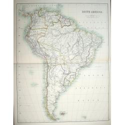
(A set of six maps of Central & South America)
This beautiful set of maps were made by Adam and Charles Black in 1889 for the library edition of "The Scribner-Black Atlas of the World" And also for "Bla...
Place & Date: Edinburgh, 1889
Selling price: $80
Sold in 2014

Exposition universelle de 1889.
Very rare broad sheet plan made for The Exposition Universelle of 1889, which was a world's fair held in Paris, from 6 May to 31 October 1889.A bird's eye view of the fai...
Place & Date: Paris, Maison Quantin, 1889
Selling price: $180
Sold
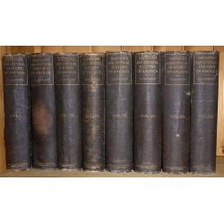
Eight volumes, ' Narrative and Critical History of America ' by Justin Winsor, complete, published by Houghton, Mifflin & Co. Boston at the Riverside Press 1889
In addition to the set in volume, I is a handwritten letter dated July 7th, 1893, signed Edward Channing, an American historian, and author of a monumental "History ...
Place & Date: Boston, 1889
Selling price: $130
Sold in 2017

Plano de la Ciudad de Buenos-Aires.
Folding plan of Buenos Aires orientated with north towards the right edge, scale c. 1½ inches to 1 kilometre. Original color to water and parks, street names printed in ...
Place & Date: (Offered by the Pintureria of Monserrat, Buenos Aires). 1890
Selling price: $110
Sold in 2012
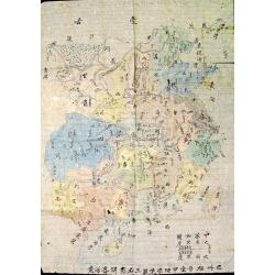
The Complete Map of China (Zhonghua Quantu)
Rare survival of a student's geography work in China, traced and colored by a late Qing Dynasty schoolboy. Not only commercial map makers made maps. Students and young pe...
Place & Date: c. 1890
Selling price: $150
Sold in 2012
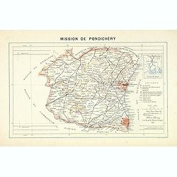
Mission de Pondichery
Important map of Pondichery in India, prepared by Adrien Launay, who was a French Missionary and later chronicler of the history of the French Missions in Indo-China at e...
Place & Date: Lille, 1890
Selling price: $170
Sold in 2017

Mission de Siam.
Important map of Thailand, prepared by Adrien Launay, who was a French Missionary and later chronicer of the history of the French Missions in Indo-China at end of the 19...
Place & Date: Lille, 1890
Selling price: $360
Sold

Japon
An interesting chromolithograph semi-cartoon map of Japan with several views from the middle 19th century.It features a boy carrying water, men playing with puppets, and ...
Place & Date: Haarlem, ca. 1890
Selling price: $42
Sold in 2017

Die Pflanze (The Plant).
This wonderful chromolithograph print incorporates botanical imagery into innovative, elaborate, Art Nouveau designs. Look closely and there are two crowned headpieces of...
Place & Date: Vienna, 1890
Selling price: $20
Sold in 2017
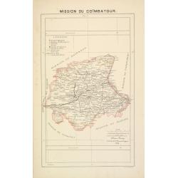
Mission du Coïmbatour.
Important missionary centered on Coimbatour. It is the Third largest city and urban agglomeration in the Indian state of Tamil Nadu, prepared by Adrien Launay, who was a ...
Place & Date: Lille, 1890
Selling price: $125
Sold in 2017
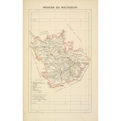
Mission du Maïssour.
Important missionary map centered on Mysor, prepared by Adrien Launay, who was a French Missionary and later chronicler of the history of the French Missions in Indo-Chin...
Place & Date: Lille, 1890
Selling price: $125
Sold in 2017

Mission du Cambodge.
Important missionary map showing Cambodia, prepared by Adrien Launay, who was a French Missionary and later chronicler of the history of the French Missions in Indo-China...
Place & Date: Lille, 1890
Selling price: $110
Sold in 2015

Mission de Cochinchine orientale.
Important missionary map showing central part of Vietnam, prepared by Adrien Launay, who was a French Missionary and later chronicler of the history of the French Mission...
Place & Date: Lille, 1890
Selling price: $65
Sold in 2016

Mission de Cochinchine septentrionale.
Important missionary map showing part of Vietnam, prepared by Adrien Launay, who was a French Missionary and later chronicler of the history of the French Missions in Ind...
Place & Date: Lille, 1890
Selling price: $40
Sold in 2016

Tong-King Méridional.
Important missionary map showing part of Vietnam, prepared by Adrien Launay, who was a French Missionary and later chronicler of the history of the French Missions in Ind...
Place & Date: Lille, 1890
Selling price: $40
Sold in 2016
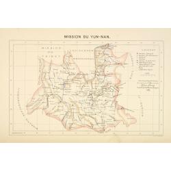
Mission du Yun-Nan.
Important missionary map showing part of China, prepared by Adrien Launay, who was a French Missionary and later chronicler of the history of the French Missions in Indo-...
Place & Date: Lille, 1890
Selling price: $100
Sold
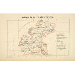
Mission du Su-Tchuen Oriental.
Important missionary map showing part of China, prepared by Adrien Launay, who was a French Missionary and later chronicler of the history of the French Missions in Indo-...
Place & Date: Lille, 1890
Selling price: $60
Sold
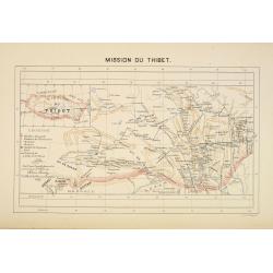
Mission du Thibet.
Important missionary map showing Tibet, prepared by Adrien Launay, who was a French Missionary and later chronicler of the history of the French Missions in Indo-China at...
Place & Date: Lille, 1890
Selling price: $150
Sold

Mission du Japon méridional. (Kyushu)
Important missionary map showing Kyushu in southern Japan, prepared by Adrien Launay, who was a French Missionary and later chronicler of the history of the French Missio...
Place & Date: Lille, 1890
Selling price: $80
Sold in 2016

Mission du Japon central.
Important missionary map showing the northern part of Honshu, including Tokyo and Hokkaido. In upper left inset of Kuriles Islands. Prepared by Adrien Launay, who was a F...
Place & Date: Lille, 1890
Selling price: $90
Sold in 2016
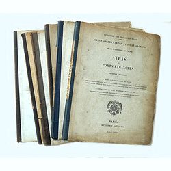
Atlas des ports étrangers. (Complete set of six volumes)
Six volumes, large 4°. First volume: 25 plates, 2nd volume: 24 plates, third volume: 25 plates, fourth volume: 24 plates, 5th volume: 23 plates, 6th volume: 13 plates: i...
Place & Date: Paris, Imprimerie Nationale 1884-1886-1887-1888-1889-1890
Selling price: $1950
Sold in 2014
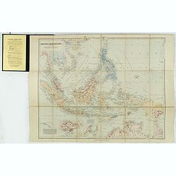
Asiatic Archipelago on Mercator's projection.
Charming, folding map of Indonesia, with Philippines, Papua new Guinea and inset maps of Singapore (80x12mm.) and Labuan (65x72mm.) a federal territory of Malaysia off th...
Place & Date: London, ca. 1890
Selling price: $350
Sold in 2015
Ju Hachi Shiryaku - Summaries of the 18 eras.
A wonderful medium-sized atlas of Chinese maps, showing the geographic extent of various Chinese dynasties.10 woodblock maps of China - 2 maps per page. Meiji 22. Maps by...
Place & Date: Meiji 22 or ca. 1890
Selling price: $200
Sold in 2016

Bilder aus den Tatarischen Dörfern in Russland.. II. Bogen.
Originally hand colored wood block engravings, published in "Münchener Bilderbogen" and published ca. 1890.
Place & Date: München, 1890
Selling price: $10
Sold in 2016

Bilder aus den Tartarischen Dörfern bei Kasan in Rusland. I. Bogen.
Originally hand colored wood block engravings, published in "Münchener Bilderbogen" and published ca. 1890.
Place & Date: München, 1890
Selling price: $20
Sold in 2016

Singapore.
A simplified plan of Singapore, including streets and rivers. Names the Racecourse, the Palace of the Governor, Fort Canning, and the Battery. Indicates the depth of the ...
Place & Date: London, ca. 1890
Selling price: $160
Sold in 2016

Manuscript map of the Philippine Archipelago.
An unusual small, and basic manuscript map of the Philippine Archipelago. Many small islands named.
Place & Date: London, ca. 1890
Selling price: $120
Sold in 2016

Galapagos Islands.
An unusual small, and basic manuscript map of the Galapagos Islands in the Pacific Ocean, off the coast of South America. It looks as though the map depicts an explorers ...
Place & Date: London, ca. 1890
Selling price: $75
Sold in 2017
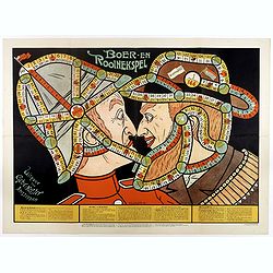
Boer-en Rooinekspel.
Design by E.G.Schlette.
Place & Date: Amsterdam, Koster, ca. 1890
Selling price: $450
Sold in 2017
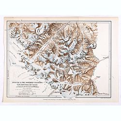
Dych-Tau & the Northern Glaciers of the Central Group of the Caucasus from surveys by M.M.Jukoff & Bogdanoff. . .
Early map of Dykh-Tau or Dykhtau, from surveys by M.M.Jukoff & Bogdanoff. Dykh-Tau is a mountain located in Kabardino-Balkaria, Russia, its peak stands about 5 km (3 ...
Place & Date: London, Edward Stanford, 1890
Selling price: $50
Sold in 2019
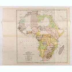
A map of Africa Showing the boundaries settled by international treaties & agreements.
Map of Africa with a color key showing the British, French, German, Italian, Portuguese and Spanish boundaries settled by international treaties and agreements. Free trad...
Place & Date: London, Edward Stanford, 1890
Selling price: $75
Sold in 2017
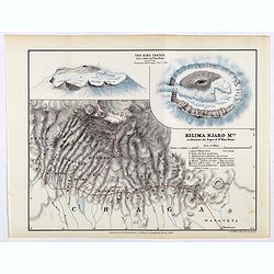
Kilima Njaro Mtn. to illustrate the paper of Dr. Hans Meyer.
One of the first maps of Mount Kilima Njaro with insets of the Bibo Crater, the route of dr. Hans Meyer shown in a red line.Fine colored lithograph map lithographed by F....
Place & Date: London, Edward Stanford, 1890
Selling price: $625
Sold in 2017

East Africa. Mounts of the Zambesi River surveyed by Daniel J.Rankin, M.R.A.S. 1889.
One of the first maps of the mouths of the Zambesi River surveyed by Daniel J.Rankin in 1889, his track shown in a red line.Fine colored lithograph map lithographed by Tu...
Place & Date: London, Edward Stanford, 1890
Selling price: $25
Sold in 2019

Sketch map of the route of the Emin Pasha relief expedition from the mounth of the Aruwimi to Bagamyo 1887 to 1889.
One of the first maps of the Emin Pasha relief expedition route from the mouth of the Aruwimi to Bagamoyo 1887 to 1889, his track shown in a red line.Fine colored lithogr...
Place & Date: London, Edward Stanford, 1890
Selling price: $60
Sold in 2017

Arab horsemen.
Adolf Schreyer (July 9, 1828 Frankfurt-am-Main – July 29, 1899 Kronberg im Taunus) was a German painter, associated with the Düsseldorf school of painting. His subject...
Place & Date: Cologne, ca. 1890
Selling price: $220
Sold in 2019

Théâtre de l'Olympia.
Chromo lithographed poster, "Théâtre de l'Olympia.", by PAL. Plate 35, published in 1896. The "Les Maitres de l'Affiche" contained 256 reduced litho...
Place & Date: Paris, Imprimerie Chaix, 1890
Selling price: $100
Sold in 2018

A Map of Africa Showing the Boundaries Settled by International Treaties & Agreements.
An interesting political map showing the boundaries of Africa, based on treaties and agreements as at 1890. It was printed for Sandford’s Geographical Establishment.The...
Place & Date: London, 1890
Selling price: $75
Sold in 2018
![[Untitled Turkish map of Central America, from California until Honduras]](/uploads/cache/81325-250x250.jpg)
[Untitled Turkish map of Central America, from California until Honduras]
An unusual Turkish map of Central America, from California until Honduras, including parts of today's Arizona, New Mexico, Texas and Louisiana. A highly collectible Ottom...
Place & Date: Turkey, ca. 1890
Selling price: $41
Sold in 2018