Browse Listings
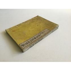
![[142 Indian Mica paintings.]](/uploads/cache/42949-250x250.jpg)
[142 Indian Mica paintings.]
One hundred and forty-two Mica Paintings of castes, people of India, trades-people, musicians, snake charmers.The majority of these paintings were produced in standard se...
Place & Date: India, 1850 to ca.1880
Selling price: $1600
Sold in 2019
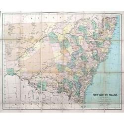
New South Wales.
Large and detailed folding map of New South Wales. 24 segments on linen. Original cover with gilt title. Advert label inside. Published by George Philip & Son 32 Flee...
Place & Date: London & Liverpool, ca. 1880
Selling price: $20
Sold in 2019

Plans of the most important cities and towns of continental Europe accompanying the special edition of Bradshw's continental railway, steam transit, &c. Guide and general handbook.
Including plans of Paris, Lyon, Marseilles, Ostend, Ghent, Brussels, Antwerp, The Hague, Cologne, Mayence, Frankfort on the Maine, Dresden, Hamburg, Munich, Berlin, Tries...
Place & Date: Birmingham, 1880
Selling price: $210
Sold in 2020
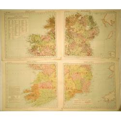
Ireland (4 Sheets).
Original map for Letts’s Popular Atlas of the World published in 1889 by Mason & Payne of London. This map is printed in color on four sheets, and has the added sta...
Place & Date: London, c1880
Selling price: $30
Sold in 2019

A Chinese Mandarin fan of a Palace garden scene.
Folding fan made of sheet paper, gouache painting depicting a lively garden of a dignitary and servants whose costumes are silk applied (in relief), the heads of the char...
Place & Date: China, 1880
Selling price: $900
Sold in 2021

Die Österreichisch & Ungarischen Eisenbahnen der Gegewart und der Zukunst.
Rare rail-way folding map of Austria, Hungary and Galicia (centered on Lviv, or Lemberg ). Published in Vienna, by Artaria & Co. The firm was founded by the cousins C...
Place & Date: Vienna, 1881
Selling price: $110
Sold in 2013

Carte du bassin compris entre la Sardaigne, l'Italie, et la Sicile. . . N° 021.
A detailed of the Sardinia, Italy and Sicily Basin. Corrections made in 1881.
Place & Date: Paris, 1863-1881
Selling price: $200
Sold in 2015

The Great East River Suspension Bridge. Pont de Brooklyn. Connecting the cities of New York and Brooklyn.
A very decorative print of the Brooklyn Bridge. The bridge enters the print at center left, the New York end of the bridge is at right, with lower Manhattan. Featured wit...
Place & Date: New York, 1881
Selling price: $700
Sold in 2014

Boston.
A highly detailed late -19th century plan of the city of Boston. It depicts the entire city in remarkable detail, noting individual streets, important public buildings, r...
Place & Date: London, 1881
Selling price: $150
Sold in 2020
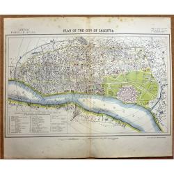
Plan of the City of Calcutta.
A highly detailed late -19th century plan of the city of Calcutta. It depicts the entire city in remarkable detail, noting individual streets, important public buildings,...
Place & Date: London, 1881
Selling price: $120
Sold in 2020
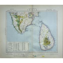
A set of Twelve maps of India.
>A set of 12 highly detailed and beautifully colored maps of India at the time of the British Raj. The maps show in high detail; Railways existing and under constructi...
Place & Date: London, 1881
Selling price: $200
Sold in 2019

Set of 6 maps South America.
A set of 6 highly detailed colored maps of the different countries that go to make up the whole of South America.Each map with a color key to British Consulates and Briti...
Place & Date: London, 1881
Selling price: $160
Sold in 2020
![[ Set of 6 Star Maps ]](/uploads/cache/82691-250x250.jpg)
[ Set of 6 Star Maps ]
Set of six Star Maps by Thomas Letts including North Polar and South Polar.
Place & Date: London, 1881
Selling price: $210
Sold in 2019

La France. Nouvel Atlas illustré des départements et des colonies..
Uncommon and decorative title page in typical neo-gothic style. In bottom a globe and map of France. Engraved by Dyonnet.
Place & Date: Paris, 1881
Selling price: $20
Sold

Fenètre Louis XVI, Fantaisie.
Very decorative and colorful lithography of an elegant French interior. From "La Tenture FranÇaise, published by G.Mathière, 32/34 Rue de Charonne, Paris.
Place & Date: Paris 1882
Selling price: $40
Sold

Chambre de demoiselle fenètre Louis XVI.
Very decorative and colorful lithography of an elegant French interior. From La Tenture Française/I>, published by G.Mathière, 32/34 Rue de Charonne, Paris.
Place & Date: Paris 1882
Selling price: $60
Sold
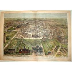
OUR NATIONAL CAPITAL VIEWED FROM THE SOUTH
A handsome, hard to find, double page bird's-eye panorama of Washington D.C. as seen in the early 1880's. This finely engraved wood-cut provides excellent detail of the c...
Place & Date: New York, 1882
Selling price: $290
Sold

Carta das Lagoas dos Patos, Mirim e dos Canaes que as ligao a Barra do Rio Grande do Sul..
Large lithography illustrating the coastal area of the Brazilian state "Rio Grande do Sul", namely the 2 large lagoons Merin and dos Patos.With 3 inset maps sup...
Place & Date: Rio de Janeiro, 1882
Selling price: $700
Sold in 2013
Carte de la Mer de Chine. . . N° 3002.
Sea chart depicting the China Sea prepared by the French Ingenieur L.Manen. The Chart is updated for the year 1882, and must have served the French during the Sino-French...
Place & Date: Paris, 1871 updated to September 1882
Selling price: $350
Sold in 2009

Fenètre de Salon Louis XVI. . .
Very decorative and colorful lithography of an elegant French interior. From La Tenture Française, published by G.Mathière, 32/34 Rue de Charonne, Paris.
Place & Date: Paris, 1882
Selling price: $20
Sold in 2023

Fenètre de Salon Louis XVI. . .
Very decorative and colorful lithography of an elegant French interior. From La Tenture Française, published by G.Mathière, 32/34 Rue de Charonne, Paris.
Place & Date: Paris, 1882
Selling price: $20
Sold in 2023
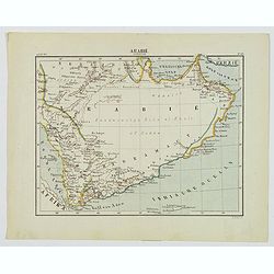
Arabie Zuidelijk.
A nice small Dutch map of southern Arabia in the late 19th century. With plenty of coastal detail, the interior was yet to be explored and recorded. The map shows Mecca, ...
Place & Date: Amsterdam, 1882
Selling price: $50
Sold in 2020

(Certificate) Accion ordinarias de 500 Pesetas.
Beautifully engraved certificate from the Compania General De Tabacos De Filipinas issued in 1882. This historic document has an ornate border with a vignette of allegori...
Place & Date: Barcelona, 1882
Selling price: $60
Sold in 2012
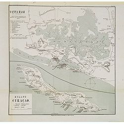
St. Anna Baai op Curaçao. / Eiland Curaçao.
Very detailed (1:20.000) lithographed map of St. Anna Bay, including Willemstad with the historic center of the city with Punda and Otrobanda. on the island Curaçao as s...
Place & Date: Amsterdam-Utrecht, K.N.A.G./ C.L.Brinkman, J.J.Beijers, 1882
Selling price: $95
Sold in 2013

St. Anna Baai op Curaçao. / Eiland Curaçao.
Very detailed (1:20.000) lithographed map of St. Anna Bay, including Willemstad with the historic center of the city with Punda and Otrobanda. on the island Curaçao as s...
Place & Date: Amsterdam-Utrecht, K.N.A.G./ C.L.Brinkman, J.J.Beijers, 1882
Selling price: $95
Sold in 2015
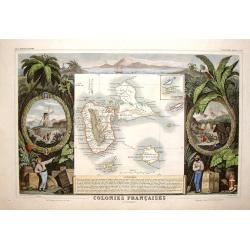
Colonies Francais en Amerique - Guadaloupe & St. Martin's.
Beautiful map of the Caribbean Islands of Guadeloupe and Grande Terre. The map is surrounded by several elaborate decorative engravings designed to illustrate the richnes...
Place & Date: Paris, 1882
Selling price: $99
Sold in 2015
The Comprehensive Atlas & Geography of the World 1882 Blackie & Son
The full title of the atlas: 'The Comprehensive Atlas & Geography of the World comprising An Extensive Series of Maps, A Description, Physical and Political of all th...
Place & Date: Glasgow, 1882
Selling price: $300
Sold in 2016
The Chinese Empire Compiled from Native and Foreign Authorities.
Extremely detailed map of China and Korea with inset of Hong Kong & the Pearl River Delta and Amoy. Published by Charles Scribner's Sons.
Place & Date: New York, 1883
Selling price: $36
Sold in 2012

The Imperial Coronation at Moscow.... 19 woodblock engravings
A collection of 19 woodblock engravings from "The Illustrated London News" mostly dated June 1883. The engravings display all phases of the Imperial Coronation ...
Place & Date: London, 1883
Selling price: $120
Sold in 2016

The High and Mighty Prince James.
Portrait of James I (The High & Mighty Prince James) as king. Half length with short hair, plumed hat, beard, closed ruff, embroidered jacket, and mantle, holding orb...
Place & Date: London, 1603 - 1883
Selling price: $20
Sold in 2016
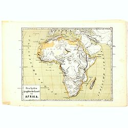
Oro-Hydrographische Kaart van Afrika.
One of the earliest thematic maps of Africa published in the Netherlands from "Atlas der natuurkundige aardrijkskunde. . .". prepared by Nicolaas Wilhelmus Post...
Place & Date: Amsterdam, C.L. Brinkman, 1883
Selling price: $20
Sold in 2016
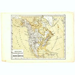
Oro-Hydrographische Kaart van Noord-Amerika.
One of the earliest thematic maps of North America published in the Netherlands from "Atlas der natuurkundige aardrijkskunde. . .". prepared by Nicolaas Wilhelm...
Place & Date: Amsterdam, C.L. Brinkman, 1883
Selling price: $20
Sold in 2018
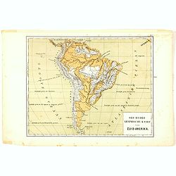
Oro-Hydrographische Kaart van Zuid-Amerika.
One of the earliest thematic maps of South America published in the Netherlands from "Atlas der natuurkundige aardrijkskunde. . .". prepared by Nicolaas Wilhelm...
Place & Date: Amsterdam, C.L. Brinkman, 1883
Selling price: $20
Sold in 2020
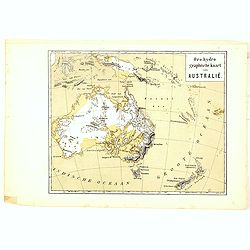
Oro-Hydrographische Kaart van Australië.
One of the earliest thematic maps of Australia and New Zealand published in the Netherlands from "Atlas der natuurkundige aardrijkskunde. . .". prepared by Nico...
Place & Date: Amsterdam, C.L. Brinkman, 1883
Selling price: $20
Sold in 2021
Geologische Kaart der Geheele Aarde.
One of the earliest thematic world maps published in the Netherlands from "Atlas der natuurkundige aardrijkskunde. . .". prepared by Nicolaas Wilhelmus Posthumu...
Place & Date: Amsterdam, C.L. Brinkman, 1883
Selling price: $1
Sold in 2023
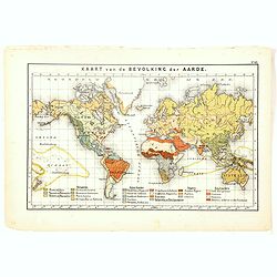
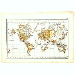
Kaart van de Bavolking der Aarde.
One of the earliest thematic world maps published in the Netherlands from "Atlas der natuurkundige aardrijkskunde. . .". prepared by Nicolaas Wilhelmus Posthumu...
Place & Date: Amsterdam, C.L. Brinkman, 1883
Selling price: $20
Sold in 2016
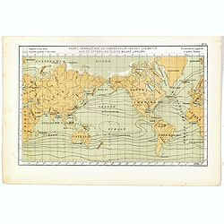
Kaart, Aanwujzende de temperatuur van het zeewater aan de oppervlakte, in de maand Januari.
One of the earliest thematic maps published in the Netherlands from "Atlas der natuurkundige aardrijkskunde. . .". prepared by Nicolaas Wilhelmus Posthumus. The...
Place & Date: Amsterdam, C.L. Brinkman, 1883
Selling price: $20
Sold in 2020
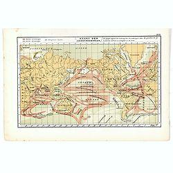
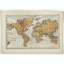
Kaart der Zeestroomingen.
World map with ocean currents. One of the earliest thematic maps published in the Netherlands from "Atlas der natuurkundige aardrijkskunde. . .". prepared by Ni...
Place & Date: Amsterdam, C.L. Brinkman, 1883
Selling price: $20
Sold in 2018
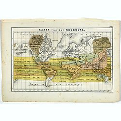
Kaart van den Regenval.
One of the earliest thematic maps showing a World map in Mercator projection of the rainfall. Published in the Netherlands from "Atlas der natuurkundige aardrijkskun...
Place & Date: Amsterdam, C.L. Brinkman, 1883
Selling price: $20
Sold in 2019
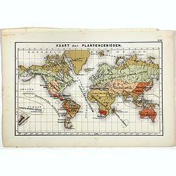
Kaart der Plantengebieden.
One of the earliest thematic maps published in the Netherlands showing a world map of Plant Areas, accompanied by 5pp text sheets with illustrations. From "Atlas der...
Place & Date: Amsterdam, C.L. Brinkman, 1883
Selling price: $20
Sold in 2019
Kaart der Isogonen en Isoklinen.
One of the earliest thematic maps published in the Netherlands from "Atlas der natuurkundige aardrijkskunde. . .". prepared by Nicolaas Wilhelmus Posthumus. The...
Place & Date: Amsterdam, C.L. Brinkman, 1883
Selling price: $20
Sold

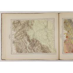
Parts of Western Wyoming, Southeastern Idaho and Northeastern Utah.
A fine, detailed economic map of portions of the mid-western states of Wyoming, Idaho and Utah, published in 1883 in Hayden's 12th Annual Report. It is a spectacular, ear...
Place & Date: Washington, 1883
Selling price: $13
Sold in 2018
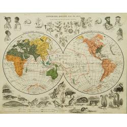
Mappemonde dressée par TH. Joly.
A World map centered on Oceania and surrounded by animals and vegetables from this region. The human being is classified according to six principal races. Gerard Mercator...
Place & Date: Paris c. 1883
Selling price: $285
Sold
Mer Baltique - Côte de Prusse - De Rixhöft A Brüsterort. . .
A well engraved and highly detailed chart focused on the Gulf of Danzig and encompassing the area between Cape Rozewie and Samland.A few places highlighted in red and yel...
Place & Date: Paris, 1883
Selling price: $750
Sold in 2020

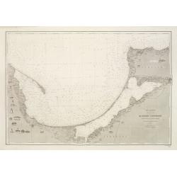
Bonifacio Strait from an Italian Government Survey, 1879. The South Coast of Corsica with the adjacent islands and rocks from a French Government Survey 1884. . .
Detailed chart of the southern Corsican coast with adjacent islands and rocks. Map is taken from an Italian Government Survey dated 1879. Lighthouses marked in yellow and...
Place & Date: London, 1879 & updated 1883
Selling price: $600
Sold in 2010
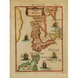
Terre de Iesso.
A charming small map of Hokkaido and the northern part of Honshu. With four western ships in the sea, by Allain Manneson Mallet (1630-1706), a well traveled military engi...
Place & Date: Franckfurth 1884
Selling price: $300
Sold

PANORAMIC VIEW OF NEW ORLEANS - THE FEDERAL FLEET AT ANCHOR IN THE RIVER, APRIL 25TH, 1862
A superb bird's-eye panoramic view of the city of New Orleans in April, 1862. From a special 1884 publication titled: "The Soldier in our Civil War an Illustrated H...
Place & Date: New York, 1884
Selling price: $300
Sold
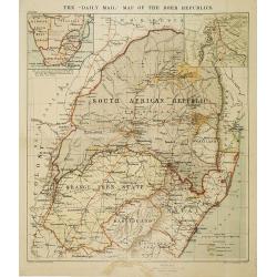
The "Daily Mail" map of the Boer Republics.
Map of the South African Republic, with two inset maps of South Africa and Natal. In lower right keys Railways, roads and British and Portuguese processions and goldfield...
Place & Date: London, Liverpool, ca.1884
Selling price: $50
Sold in 2009
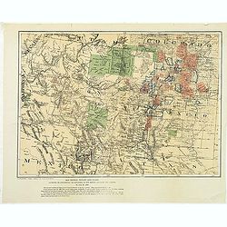
Map showing private land claims, patented or unpatented or cinfirmed in New Mexico, Colorado and Arizona.
Rare map showing private land claims, patented or unpatented or confirmed in New Mexico, Colorado and Arizona to accompany Thomas Donaldson "The Public Domain, Its H...
Place & Date: Washington, 1884
Selling price: $25
Sold in 2012

Carta dimostrativa delle Circoscrizioni Militari del Regno d'Italia 1884
Decorative military map of Italy from 1884 printed on cloth/linen. The map shows the military districts of the Kingdom of Italy in 1884 and is surrounded with coats of ar...
Place & Date: Italy, ca.1884
Selling price: $45
Sold in 2012
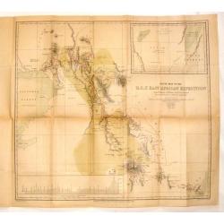
Route Map of the R.G.S. East African Expedition.
Fine map of East Africa published for the Proceedings of the Royal Geographical Society (R.G.S.). Mapmaker was E. Weller.The map area is from Mombasa to Mount Kenia &...
Place & Date: London, 1884
Selling price: $169
Sold in 2014

Carte Particuliere de la Cote du Bresil.
Large detailed map of the coast of Brazil from The Bay of Sapetiba to the Island of Sao Sebastia. It was priced at two francs when produced. Depot de la Marine (1720 - ...
Place & Date: Paris, 1884
Selling price: $99
Sold in 2013
Hyouchuu Hasshiryaku Kouhon - Summaries of the 18 Histories, Volume 1
A larger sized, beautiful atlas of Chinese maps, showing the geographic extent of various Chinese dynasties. 10 double page woodblock maps of China. Meiji 16 (1884) text ...
Place & Date: 1884
Selling price: $210
Sold in 2016
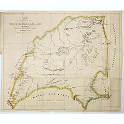
Map Showing The Boundaries Of The South African Republic As Defined By Article I Of The Convention Of London Dated February 27Th 1884
Frederick Dangerfield map of the South African Republic (1884). Map showing the Boundaries of the South African Republic as defined by Article I of the Convention of Lond...
Place & Date: London, Houses Of Parliament ,1884
Selling price: $200
Sold in 2017
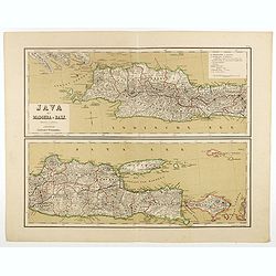
Java met Madoera en Bali. Schaal van 1:1750000.
A very detailed map of Java is divided in two parts, taken from "Atlas van Nederlandsch Oost- en West-Indie," prepared by a doctor I. Dornseiffen, and published...
Place & Date: Amsterdam, Seyffardt, 1884
Selling price: $35
Sold in 2017
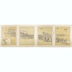
Java op een schaal van 1:950 000
Very detailed map of Java in 4 sheets, with an inset map of 'Batavia met de haven werken' (Jakarta). Taken from "Atlas van Nederlandsch Oost- en West-Indie", pr...
Place & Date: Amsterdam, Seyffardt, 1884
Selling price: $50
Sold in 2017
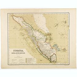
Sumatra, Bangka, Blitong, Riouw, enz. (with Singapore)
Very detailed map of Sumatra, with Singapore to the East, taken from "Atlas van Nederlandsch Oost- en West-Indie", prepared by doctor I. Dornseiffen, and publis...
Place & Date: Amsterdam, Seyffardt, 1884
Selling price: $175
Sold in 2017
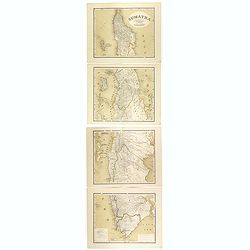
Sumatra op een schaal van 1: 1450000
Very detailed map of Sumatra on 4 sheets, taken from "Atlas van Nederlandsch Oost- en West-Indie", prepared by doctor I. Dornseiffen, and published by published...
Place & Date: Amsterdam, Seyffardt, 1884
Selling price: $85
Sold in 2017
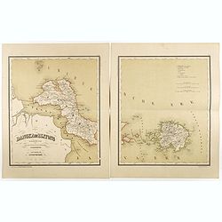
Bangka en Blitong op een schaal van 1:750000.
Very detailed two sheet map of Bangka en Blitong, taken from "Atlas van Nederlandsch Oost- en West-Indie", prepared by doctor I. Dornseiffen, and published by p...
Place & Date: Amsterdam, Seyffardt, 1884
Selling price: $30
Sold in 2018
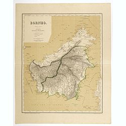
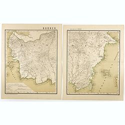
Borneo op een schaal van 1:420000.
Very detailed two sheet map of Borneo with some good detail to Brunei as well, taken from "Atlas van Nederlandsch Oost- en West-Indie", prepared by doctor I. Do...
Place & Date: Amsterdam, Seyffardt, 1884
Selling price: $130
Sold in 2017
Borneo op een schaal van 1:1800000.
Very detailed two sheet map of Southern part of Borneo in two sheets, taken from "Atlas van Nederlandsch Oost- en West-Indie", prepared by doctor I. Dornseiffen...
Place & Date: Amsterdam, Seyffardt, 1884
Selling price: $20
Sold in 2017
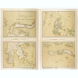
Celebes en de Molukken in vier bladen.
Very detailed four-sheet map of Celes and the Moluccas on a scale of 1:1800000, taken from "Atlas van Nederlandsch Oost- en West-Indie," prepared by a doctor I....
Place & Date: Amsterdam, Seyffardt, 1884
Selling price: $22
Sold in 2017
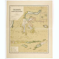
Celebes, de kleine Soenda eilanden, enz. Schaal van 1:4200000.
Very detailed two sheet map of Moluccas, taken from "Atlas van Nederlandsch Oost- en West-Indie", prepared by doctor I. Dornseiffen, and published by published ...
Place & Date: Amsterdam, Seyffardt, 1884
Selling price: $30
Sold in 2017
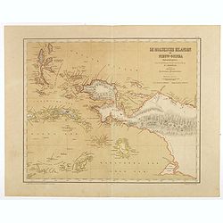
De Moluksche eilanden en Nieuw-Guinea (Nederlandsch gedeelte) . . . schaal van 1:4200000.
Very detailed two sheet map of New Guinea with good detail to the Moluccas as well, taken from "Atlas van Nederlandsch Oost- en West-Indie", prepared by doctor ...
Place & Date: Amsterdam, Seyffardt, 1884
Selling price: $30
Sold in 2017
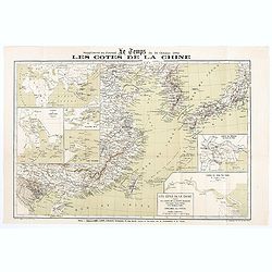
Les Côtes de la Chine supplément au journal le temps du 16 Octobre 1884
Map of the Chinese coasts, with an inset showing Europe, Africa, Arabia and the Asian continent, with part of Australia and showing the route from France to China. Publis...
Place & Date: Paris, October 6th, 1884
Selling price: $75
Sold in 2020
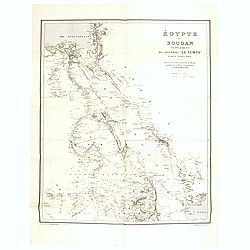
Egypte et Soudan supplément au journal "Le Temps", Paris, Mars 1884
Detailed map of Egypt, engraved by R.Haussmann and published as supplement in "LeTemps", published by Roland Bonaparte (1858-1924), geographer and president of ...
Place & Date: Paris, 1884
Selling price: $25
Sold in 2020

Heath's Fern Portfolio.
Illustrated with fifteen chromo-lithographed color plates. All the species of British ferns are included in this volume. The work is intended to present a series of life-...
Place & Date: London, 1885
Selling price: $360
Sold in 2019
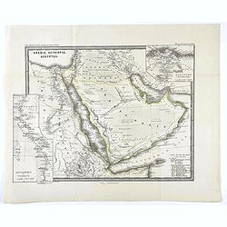
Arabia, Aethiopia, Aegyptus.
Map of the Arabian peninsula from "Histoire du Commerce du Monde". Inset maps of Egyptus Inferior and Heptanomis et Thebais.
Place & Date: Gaotha, ca. 1885
Selling price: $100
Sold in 2020

Iles Pescadores <Chine>.
Very interesting water color most probably made in Ki-lung (Jilong in northern Taiwan) by a French eye-witness during the short time France occupied the Pescadores and Fo...
Place & Date: Kilung [Jilong], Mai 1885
Selling price: $5250
Sold

Carte commerciale de la province de Thrace. . .
Rare separately issued folding example of Bianconi's map of the European part of Turkey. F Bianconi directed a series of "Carte commerciale" of all countries; t...
Place & Date: Paris, Librairie Chaix, 1885
Selling price: $200
Sold in 2012

A collection of 5 maps North and South America, Canada.
A collection of 5 maps North and South America, Canada by W. & A.K. Johnston and published by W & R Chambers, of London & Edinburgh.The map of Canada, South A...
Place & Date: London, 1885
Selling price: $80
Sold in 2012

A set of 16 humorous prints of Russian interest and The Russian Empire's war with the French and British Empire's.
This set of 16 are from 1853 - 1885. Mostly engraved by Joseph Swain. Joseph Swain was one of the most important woodblock engravers.Punch was responsible for the word se...
Place & Date: London 1853 - 1885
Selling price: $100
Sold in 2016
![[LOT OF 4] Flower prints.](/uploads/cache/92621-250x250.jpg)
[LOT OF 4] Flower prints.
Interesting set of four old prints/lithographs: 1) "Nepenthes Sanderiana" Robinson - Henry G Moon, ca. 1903? 2) "Croton Duvivieri" Depannemaeker &...
Place & Date: France, after 1885
Selling price: $20
Sold in 2013
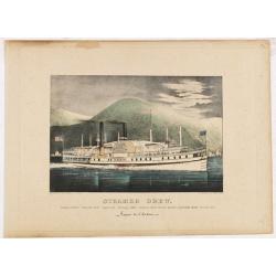
Steamer Drew. Vapeur de l'Hudson.
A very decorative print of the steamboat "Drew" sailing on the Hudson River.Published by Currier & Ives 125 Nassau Street, New York."Currier & Ives...
Place & Date: New York, ca. 1885
Selling price: $350
Sold in 2014
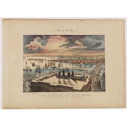
The Harbor of New York. Pont de Brooklyn.
A very decorative print of New York Harbor and Brooklyn Bridge. Five men stand or sit on the Brooklyn Bridge tower in the foreground. The harbor extends to the horizon at...
Place & Date: New York, ca. 1885
Selling price: $1550
Sold in 2014
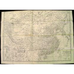
(Ortographische und geologische Karten. Erste Abtheilung: Das nördliche China.)
Very rare atlas of Northern China prepared by and during the lifetime of Ferdinand Freiherr von Richthofen. It is considered to be the first scientific atlas about China,...
Place & Date: Berlin, D.Reimer, 1885
Selling price: $2500
Sold
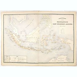
Overzichtskaart van den Nederlandsch oost Indischen Archipel.
Very detailed map of Indonesia, taken from "Atlas der Nederlandsche bezittingen in Oost-Indië", who was published by Departement van Koloniën". Including...
Place & Date: The Hague, 1883-1885
Selling price: $50
Sold in 2017
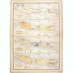
Kaart van Java en Madoera . . .
Four maps of Java and Madoera on one sheet taken from "Atlas der Nederlandsche bezittingen in Oost-Indië", who was published by Departement van Koloniën"...
Place & Date: The Hague, 1883-1885
Selling price: $55
Sold in 2017
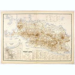
Kaart van West Java (eerste militaire afdeeling)
Very detailed map of west Java, taken from "Atlas der Nederlandsche bezittingen in Oost-Indië", who was published by Departement van Koloniën". With inse...
Place & Date: The Hague, 1883-1885
Selling price: $75
Sold in 2016
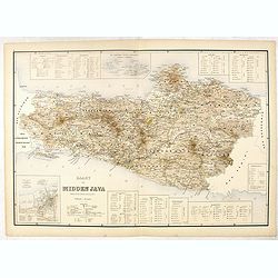
Kaart van Midden Java. ( tweede militaire afdeeling )
Very detailed map of central Java, taken from "Atlas der Nederlandsche bezittingen in Oost-Indië", who was published by Departement van Koloniën". In low...
Place & Date: The Hague, 1883-1885
Selling price: $50
Sold in 2016