Browse Listings
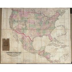
Colton's Map of the United States of America The British Provinces, Mexico and the West Indies, Showing the Country from the Atlantic to the Pacific Oceans.
Large folding map of the United States. Dissected and mounted onto linen in 60 sections. Original linen backing with original slip case. Published by G W & C B Colton...
Place & Date: New York 1870
Selling price: $600
Sold in 2013

Instantaneous Indicator New Plan of Paris with Ribbon. . .
Instantaneous Indicator New Plan of Paris with Ribbon complete & reetify [sic], for circulating in Paris like the most acquinted [sic] with it, System Acklin, patente...
Place & Date: Paris, Logerot, ca. 1870
Selling price: $400
Sold
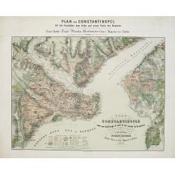
Plan de Constantinople avec ses faubourgs, le port et une partie du Bosphore..
Decorative and very detailed plan of Istanbul and its environs. With title and dedication in German and French. Lower part key to symbols.Rare in this uncut state, usuall...
Place & Date: Berlin 1870
Selling price: $1200
Sold in 2015
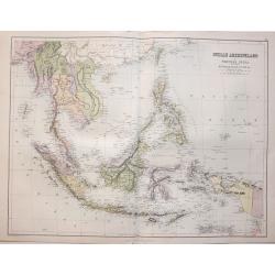
Indian Archipelago and Further India. Including Burmah, Siam, Anam &c.
The map covers the area from India - China - Formoza (Taiwan) in the North to New Guinea and the tip of Australia in the South.
Place & Date: Edinburgh, 1870
Selling price: $65
Sold in 2014
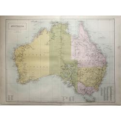
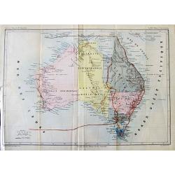
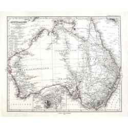
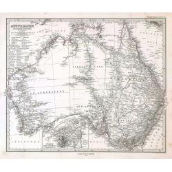
Australia.
Large scale map of Australia by John Bartholomew and published in Edinburgh by Adam & Charles Black in 1870. The map shows provincial boundaries and has high detail o...
Place & Date: Edinburgh, 1870
Selling price: $80
Sold in 2015

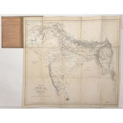
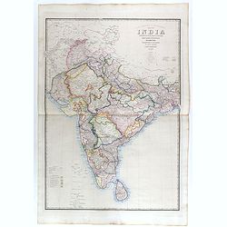
India ( on two sheets)
An extremely highly detailed map of India printed over two sheets North & South, color-coded for the different provinces. The South sheet has Ceylon (present day Sri ...
Place & Date: Edinburgh 1870
Selling price: $80
Sold in 2015

Oceania and Pacific Ocean.
A highly detailed map of the Pacific rim counties from Russia - China to Australia & New Zealand to North & South America's western coasts. Original coloring sepa...
Place & Date: Edinburgh, 1870
Selling price: $60
Sold in 2014
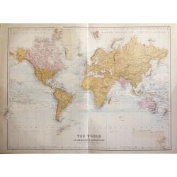
The World On Mercators Projection showing 'The British Possessions throughout the World'.
John Batholomew's map of the World showing 'The British Possessions throughout the World are colored Red'. Ocean currents are clearly marked.Published in Edinburgh by Ada...
Place & Date: Edinburgh 1870
Selling price: $60
Sold in 2015

Russia in Europe.
A highly detailed map of Russia in the late 19th century. The provinces are separated by coloring. Published in Edinburgh by Adam & Charles Black
Place & Date: Edinburgh, 1870
Selling price: $60
Sold in 2014

Italy with Sicily, Corsica, Malta, and Sardinia.
A highly detailed map of Italy with Sicily, Corsica, Malta and Sardinia by John Bartholomew Provinces are divided by colors.Published in Edinburgh by Adam & Charles B...
Place & Date: Edinburgh 1870
Selling price: $60
Sold in 2014

The Great Mississippi Steamboat Race.
A very decorative print of a steamboat race. Two riverboats, "Robert E. Lee" at left and "Natchez" at right, race from the right background toward the...
Place & Date: New York, ca. 1870
Selling price: $1350
Sold in 2014
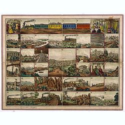
(Voyage from New York to San Francisco upon the Union Pacific Railroad).
Rare Union Pacific railroad game board based on the "new Union Pacific Railroad." The game board shows forty five beautifully executed views of places along the...
Place & Date: c. 1870
Selling price: $1000
Sold in 2014
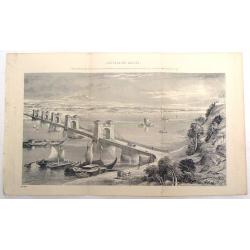
Suspension Bridge, Russia, Across the Dnieper at Kieff.
Fine lithograph of the wrought iron bar-chain suspension bridge erected by command of the Emperor of Russia. Currently, the bridge is in Kiev, Ukraine.
Place & Date: 1870
Selling price: $89
Sold in 2015
![[RARE huge world wall map in double hemisphere.]](/uploads/cache/36237-250x250.jpg)
[RARE huge world wall map in double hemisphere.]
Large world map in double hemispheres. Lithography's with strong original hand colors. A few pages with tears, but no paper missing.Francesco Vallardi tipografo was an ed...
Place & Date: Milan, Rome, Palermo, 1870
Selling price: $1250
Sold in 2015

Canada, New Brunswick, Nova Scotia, Cape Breton Island, Prince Edward Island and Newfoundland.
A large map of the South-East of Canada, including the United States until Virginia and Chesapeake Bay. Complete with an inset map of Newfoundland.Highly detailed, with m...
Place & Date: London, ca 1870
Selling price: $29
Sold in 2016

Landing of the Prince at Hong-Kong.
Nice view of the harbour with numerous ships celebrating the arrival of the Prince Alfred - the Duke of Edinburgh in Hongkong. From the Illustrated London News, January 2...
Place & Date: London, 1870
Selling price: $27
Sold in 2016

The Enchanted Lake in the Philippine Islands.
Original wood engraving drawn by Lancelot and engraved by Maurand. Beautiful scene of the lake with a deer and a crocodile. Attractive hand color.
Place & Date: London, c1870
Selling price: $20
Sold in 2016
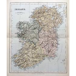
Ireland.
A highly detailed map of the island. Names many towns, areas, rivers, lochs, bays, railways etc.
Place & Date: London, Edingburgh & Glasgow, ca. 1870
Selling price: $25
Sold in 2018

Great Fire at Hong-Kong.
A view of several buildings burning with a number of people in the foreground. From the Illustrated London News, ca. 1865-1870.
Place & Date: London, ca. 1870
Selling price: $11
Sold in 2017
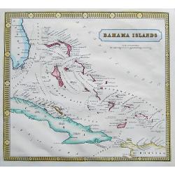
Bahama Islands.
A scarce and very detailed map of the Bahamas, including a part of Florida, Cuba, and Hispaniola. Map shows many islands, shoals and rocks. Names also the Hole in the Wal...
Place & Date: ca. 1870
Selling price: $35
Sold in 2017
![[Map of the Moon] Die sichtbare Seite der Mond-Oberflache bei voller Beleuchtung Nach Beer u Madlers Karte .](/uploads/cache/43040-250x250.jpg)
[Map of the Moon] Die sichtbare Seite der Mond-Oberflache bei voller Beleuchtung Nach Beer u Madlers Karte .
Map of the Moon, based upon the work of Johann Heinrich von Mädler ( 1794 -1874) one of the most important German astronomer's of the late 19th Century.Mädler began giv...
Place & Date: Gotha, 1870
Selling price: $180
Sold

Amerique Russe, Nouvelle Bretagne et Groenland.
A map showing the newly acquired U.S. land of Alaska, newly acquired from Russia, all of Canada and Greenland. The United States purchased Alaska from the Russian Empire ...
Place & Date: Paris, ca 1870
Selling price: $40
Sold in 2019

Temple d'Antonin et Faustine / Tempio d'Antonino e Faustina.
A nice and decorative lithograph from Rome dans sa Grandeur.
Place & Date: Paris, ca 1870
Selling price: $17
Sold in 2019

Para usted Real é Imperial frabrica de cigarros de Eduardo Guillo Habana.
Original chromo lithographed advertising poster by Testu & Massin, for the Spanish tobacco company Eduardo Guillo. Printed in Paris by Bognard & Dechavanne and R....
Place & Date: Paris, Bognard & Dechavanne and R. de la Perle, ca. 1870
Selling price: $380
Sold in 2019
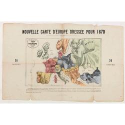
Nouvelle Carte d'Europe dressée pour 1870.
The Franco-Prussian War and The Commune in Caricature 1870-71.Satirical illustration by Paul Hadol showing disposition of power in Europe at the beginning of 1870. Satiri...
Place & Date: Paris, 1870
Selling price: $250
Sold in 2020

Colombia Prima or South America drawn from the large map in eight sheets by Louis Stanislav D'Arcy Delarochette.
2 large double page engraved maps (each 53 x 76 cm overall sheet 56 x 86 and if joined combining to make an overall sheet size of c.110 x 86 cm) with original outline col...
Place & Date: London: James Wyld. Geographer toHer Majesty Charing Cross East. 1870
Selling price: $310
Sold in 2020

Et voilà que chacun se meut, s'agite, s'escite au plaisir . . .
Erotic scene of 3 women and a man on a coach.
Place & Date: France, ca. 1870
Selling price: $150
Sold in 2021

Flags of all Nations prepared for Zell's Atlas of the World.
A rare print showing 70 flags of the World, featuring multiple British and American Flags. Also including the Sandwich Islands, Birmah, Cochin-China, Siam, Papal...
Place & Date: Philadelphia, ca 1870
Selling price: $90
Sold in 2020
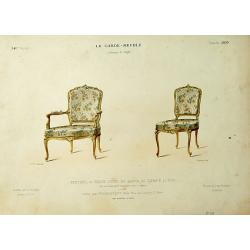
Fauteuil et Chaise Louis XV. . .
Very decorative and colorful lithography of two French chairs. From Le Garde-meuble, published by E.Maincent and D.Guilmard, 2, Rue de Lancry, Paris. Lithographed by Laro...
Place & Date: Paris, 1871
Selling price: $12
Sold in 2022

Canapé d'Angle. Transition du Louis XV et..
Very decorative and colorful lithography of an elegant sofa. From Le Garde-meuble , published by E.Maincent and D.Guilmard, 2, Rue de Lancry, Paris. Lithographed by Laroc...
Place & Date: Paris, 1871
Selling price: $50
Sold in 2021

America.
General map of America, published in Stieler's Hand Atlas .
Place & Date: Gotha, 1871
Selling price: $60
Sold in 2009
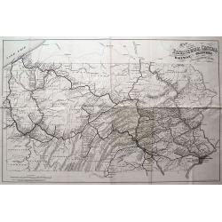
MAP OF THE PENNSYLVANIA CENTRAL RAILWAY, BRANCHES AND CONNECTING LINES.
Rare and interesting railroad map, showing the routes and stops from Philadelphia to Erie, including Pittsburgh. Very detailed with a lot of topographical information.
Place & Date: Washington D.C., 1871
Selling price: $65
Sold in 2013
![Karta Kievskoi Gubernii [Kiev Governorate, Ukraine].](/uploads/cache/34757-250x250.jpg)
Karta Kievskoi Gubernii [Kiev Governorate, Ukraine].
A detailed map of Ukraine's Kyiv Governorate, printed in St. Petersburg by Alexey Afinogenovich Ilyin, one of the most important 19th Century maps of the region.This fine...
Place & Date: St. Petersburg, 1871
Selling price: $750
Sold in 2021

La Canonnière la Farcy amarrée en face des Tuileries pendante l'incendie de Paris dans la nuit du 24 Mai 1871.
Very fine lithography in decorative original hand color of the Palais des Tuileries set on fire in the last days of the Paris Commune, either by Communards or by petrol b...
Place & Date: Paris, F. Sinnett, 1871
Selling price: $300
Sold

Cochin China. Phan-Rang Bay to Touron Bay.
Coastal chart of Cochin China and the Phan-Rang and Touron Bays. From a survey made in 1798 by Jean Dayot, and subsequently by French surveyors from 1865-66.The colonizat...
Place & Date: 1865-1866, updated to 1871
Selling price: $100
Sold in 2018
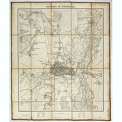
Environs de Strasbourg.
Map of Strasbourg and its direct vincinity, prepared by the Historical Section of the Major General Prussian State, map at 1 / 25,000. Published by E.S. Mittler and Sons,...
Place & Date: Berlin, 1871
Selling price: $950
Sold in 2020
*untitled*
Uncommon map of Australia by Henri Plon, published in Beauvoir's "Australie. Voyage autour du monde". A red line indicates the route of the voyage from arriving...
Place & Date: Paris, 1872
Selling price: $55
Sold in 2012
![[Tittle in Russian] Kapta. . . (Map of the Russian North Coast).](/uploads/cache/29142-250x250.jpg)
[Tittle in Russian] Kapta. . . (Map of the Russian North Coast).
A detailed wall map sized map of the Northern coast of Russia with a color key in top which seems to highlight the various Russian Artic explorations along the coast usin...
Place & Date: Moscow, 1872
Selling price: $650
Sold in 2014
Map of India to Illustrate the History of the Mutiny .
An unusual subject for this folding map of India by James Wyld the junior, the map covers the area from Afghanistan and Cashmere in the North to Ceylon(Sri Lanka) in the ...
Place & Date: London, 1872
Selling price: $60
Sold in 2016

Prussia.
Detailed map of Germany, Prussia and Poland, with unique hand-drawn details and borders. Dated 1872 by Alice Welsh. Includes several kingdoms, rivers, and cities.
Place & Date: London, 1872
Selling price: $25
Sold in 2015
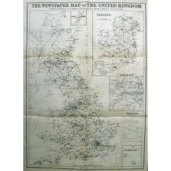
The Newspaper Map of the United Kingdom.
Large map, showing the distribution and variety of newspaper publication in the UK. A key has symbols that give an explanation of towns with one paper, more than one pape...
Place & Date: London, 1872
Selling price: $35
Sold in 2015
Australien.
A highly detailed map of Australia. With an inset map of Sydney and Port Jackson. Includes notes, explorer routes and dates.By A. Petermann, published in "Stieler's ...
Place & Date: Gotha, 1872
Selling price: $28
Sold in 2018
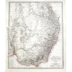
Süd-Ost Australien.
A highly detailed map of parts of Queensland, New South Wales, and Victoria, it also includes Adelaide, Melbourne, Sydney, and Brisbane. Includes notes, explorer routes a...
Place & Date: Gotha, 1872
Selling price: $10
Sold in 2018

New York City.
A nice plan of the City of New York, colored by wards. Extends north to Mount Eden, and south to Prospect Park in Brrokly. With good coverage of Manhattan and parts of Br...
Place & Date: New York, 1872
Selling price: $140
Sold in 2020
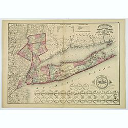
Putnam, Rockland, Westchester, New York, Richmond, Kings, Queens, and Suffolk Counties.
A detailed map of counties encompassing metropolitan New York City. The map highlights Putnam, Rockland and Westchester Counties, New York City, and, most prominently, Lo...
Place & Date: New York, 1872
Selling price: $115
Sold in 2019
General View of the Ruins after the Great Fire at Boston.
A birds-eye woodcut view of the ruins and the aftermath of the Great Fire of Boston in 1872. The view starkly illustrates those parts of the city that were wrecked, and t...
Place & Date: London, 1872
Selling price: $9
Sold in 2023
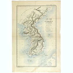
TYO SYEN Corée par les Missionnaires de Corée de la société des missions etrangéres.
A very nice map and rare map of Korea. Prepared by R.P.Carceri who was an missioner active for de la Sociéte des Missions Etrangères.Published as a supplement to Journa...
Place & Date: Lyon, 1872
Selling price: $700
Sold in 2023

Croisée Louis XVI. Marie Antoinette.
Very decorative and colorful lithography of an elegant French interior. From Le Garde-meuble , published by E.Maincent and D.Guilmard, 2, Rue de Lancry, Paris. Lithograph...
Place & Date: Paris 1872
Selling price: $50
Sold
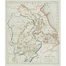
Carte du Kiang Nan ..
Detailed and very rare map of the area of Shanghai, showing the location of the missionaries' residences during the years 1871-72. P. Carceri was an missionary active for...
Place & Date: Lyon 1872
Selling price: $640
Sold
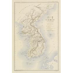
TYO SYEN Corée par les Missionnaires de Corée de la société des missions etrangéres.
A very nice map and rare map of Korea. Prepared by R.P.Carceri who was an missioner active for de la Sociéte des Missions Etrangères.Published as a supplement to Journa...
Place & Date: Lyon, 1872
Selling price: $900
Sold
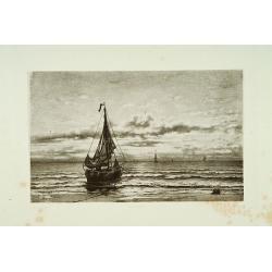
Shipping
Attractive lithography showing Dutch vessels off the Dutch coast, by J.J.Mesker after a painting by H.W.Mesdag. Published in Kunst Kroniek .
Place & Date: The Hague 1872
Selling price: $50
Sold in 2013

Carte réduite de l'Islande et des Iles Feroë. . . N°837.
Sea of Iceland and the Faroes Islands.Lighthouses are colored by hand in red and yellow. It shows soundings, anchorage's, channels, shoals, navigational sightings.
Place & Date: Paris, 1872
Selling price: $100
Sold in 2015

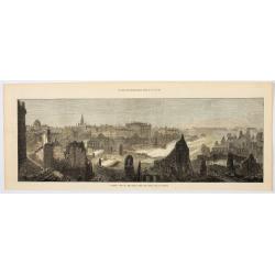
City of Boston (From South Boston).
A handsome mid 19th century panoramic view of the city of Boston as seen from the southern part of it's harbor. Many monuments are clearly visible, including the State Ho...
Place & Date: New York, 1873
Selling price: $80
Sold in 2008

Paris fashion plate.
"From Le Mode Elégant.A attractive print from a 19th century Paris women's magazine. These periodicals, whose circulation in great numbers, created height...
Place & Date: Paris 1873
Selling price: $16
Sold in 2009

New Orleans.
A famous mid 19th century view of the city of New Orleans from its southern dock section. The harbor perspective depicts a variety of river and ocean ships. Major landmar...
Place & Date: New York, 1873
Selling price: $100
Sold

Fenètre de salon empire.
Very decorative and colorful lithography of an elegant French interior. From La Tenture Française, published by G.Mathière, 32/34 Rue de Charonne, Paris.
Place & Date: Paris, 1873
Selling price: $80
Sold in 2012
Australien.
Australia by Adolph Stieler.
Place & Date: 1873
Selling price: $90
Sold in 2009
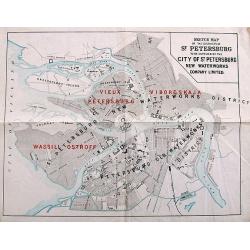
Sketch Map of the Districts of St. Petersburg to be supplied by the City of St. Petersburg New Waterworks Company Limited.
A scarce plan of St. Petersburg. The names of the districts to be "newly" supplied with water - "Vieux Petersburg" (Peterburgskaya), "Viborgskaya...
Place & Date: St. Petersburg, 1873
Selling price: $75
Sold in 2017

Polynesien und der grosse Ocean. . .
Highly detailed map of Southeast Asia, Australia and New Zealand. With numerous inset maps of islands: Carolinas, Marianas, Samoa, Fidji, New Caledonia, Tonga,... Early...
Place & Date: Gotha, 1873
Selling price: $55
Sold in 2014
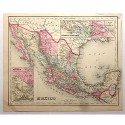
Mexico.
A comprehensive chromolithograph map of Mexico, taken from Gray's “Atlas of the United States...” Each individual county within Mexico is highlighted in a different c...
Place & Date: Philadelphia, 1873
Selling price: $20
Sold in 2018
Road, Railway & Telegraphic map of India shewing the post roads and dawk stations. . .
A large, decorative post road map also showing Indian railways. A color key is showing British possessions, subsidiary states, and protected and independent areas. Scale ...
Place & Date: London, ca. 1872/1873
Selling price: $400
Sold in 2019
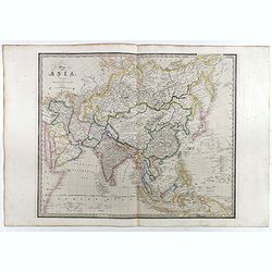
Map of Asia. . .
A large map of Asia. The map is of interest for being one of the few 19th century maps with the use of Gulf of Corea, for the sea between Korea and Japan. From "A Ne...
Place & Date: London, ca. 1872/1873
Selling price: $550
Sold

Map of the Burman Empire Including also Siam, Cochin-China, Ton-king and Malaya.
Superb map showing South East Asia, from Calcutta to Hong Kong. Includes many regions and place names such as the Burman Empire, Siam (Thailand), Cochin China and Tonking...
Place & Date: London, ca. 1872/1873
Selling price: $475
Sold in 2017

South Japan Marine Chart.
Marine chart by Amirale Cécile in 1846, but corrections in 1870 and 1873 by the Dépôt général de la marine. Meji period. A wonderful chart of the very southern part ...
Place & Date: Paris, 1873
Selling price: $340
Sold in 2021
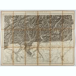
Generalkarte der Schweiz. Blatt IV.
Folding map showing the area from Mainz in the north to Bergamo and Como in the south. The map, engraved by Müllhaupt, is probably part of the 'Topographical Atlas of th...
Place & Date: Bern, 1873
Selling price: $40
Sold in 2023

Province ou dèpt de Constantine.
Decorative map of one of the provinces in Algeria from "Géographie Universelle, Atlas Migeon." published by J. Migeon. Very nice engraving of the view of Const...
Place & Date: Paris, 1874
Selling price: $35
Sold in 2017

Amérique Centrale.
Decorative map of Central America from "Géographie Universelle, Atlas Migeon." published by J. Migeon. Nice steel engraving at the upper right hand of a view o...
Place & Date: Paris, 1874
Selling price: $80
Sold in 2014
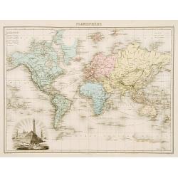
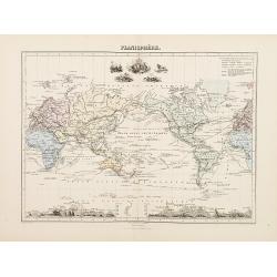
Planisphére.
Decorative map of the world from Géographie Universelle, Atlas Migeon. published by J. Migeon. Lower left cartouche with IJfel Tower, Pyramids, Statue of Liberty, a Chin...
Place & Date: Paris 1874
Selling price: $70
Sold
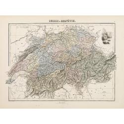
Suisse ou Helvétie.
Decorative map of Switzerland from Géographie Universelle, Atlas Migeon. published by J. Migeon. Very nice engraving of view of the Chapel of Willem Tell. Engraving by S...
Place & Date: Paris, 1874
Selling price: $30
Sold in 2011

Italie Méridionale.
Decorative map of Italy from Géographie Universelle, Atlas Migeon. published by J. Migeon. Engraved by L.Smith. Inset of the Isle of Sardine.From one of the last decorat...
Place & Date: Paris, 1874
Selling price: $20
Sold in 2019
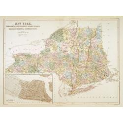
New York. Vermont, New Hempshire, Rhode Island..
A detailed lithographed map of New York, New Hampshire, Vermont, Rhode Island, Massachusetts and Connecticut. With in lower left corner inset-plan of City of New York. Pu...
Place & Date: Edinburg 1874
Selling price: $90
Sold

Italie Ancienne.
Decorative map of Italy from Géographie Universelle, Atlas Migeon. published by J. Migeon. In upper right hand corner a view of the "Temple de la Sibylle a Tivoli&q...
Place & Date: Paris, 1874
Selling price: $16
Sold in 2017
Planisphére.
Decorative map of the world from Géographie Universelle, Atlas Migeon. published by J. Migeon. Mountain-height details at the bottom of the map engraved by Sengteller.Fr...
Place & Date: Paris 1874
Selling price: $100
Sold
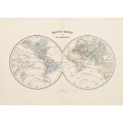
Mappe-Monde en deux Héemisphères.
Decorative map of the world from Géographie Universelle, Atlas Migeon. published by J. Migeon.From one of the last decorative atlases published in the 19th century.
Place & Date: Paris 1874
Selling price: $65
Sold

France par Départements.
Decorative map of France from Géographie Universelle, Atlas Migeon. published by J. Migeon. In lower left hand corner a view of a building in Strasbourg engraved by Schr...
Place & Date: Paris 1874
Selling price: $5
Sold
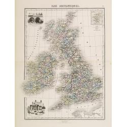
Iles Britanniques.
Decorative map of the British Isles from Géographie Universelle, Atlas Migeon. published by J. Migeon. In lower left hand corner a view of the tower of London and an eng...
Place & Date: Paris 1874
Selling price: $10
Sold

Espagne et Portugal
Decorative map of Spain and Portugal from Géographie Universelle, Atlas Migeon. published by J. Migeon. In lower right hand corner a view of Alhambra engraved by Schroed...
Place & Date: Paris 1874
Selling price: $12
Sold

Empire d'Allemange.
Decorative map of the Germany from Géographie Universelle, Atlas Migeon. published by J. Migeon. Engraving by Schroeder of a view of Mayence in the upper right corner.Fr...
Place & Date: Paris 1874
Selling price: $10
Sold
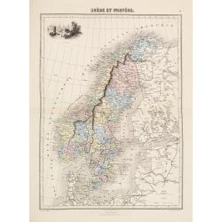
Suède et Norvége.
Decorative map of the Sweden and Norway from Géographie Universelle, Atlas Migeon. published by J. Migeon. Engraving by Schroeder of a view of the Stockholm in the upper...
Place & Date: Paris 1874
Selling price: $10
Sold
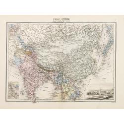
Inde, Chine
Decorative map of India and China from Géographie Universelle, Atlas Migeon. published by J. Migeon. Engraving by Schroeder of a view of Calcutta in the lower right corn...
Place & Date: Paris 1874
Selling price: $20
Sold