Browse Listings

Burma, Siam, &c.
Interesting map, extending from Bangladesh until China with Hainan island, and as far south as Singapore. Filled with place names, rivers, mountains, islands, etc.
Place & Date: London, c1865
Selling price: $15
Sold in 2018
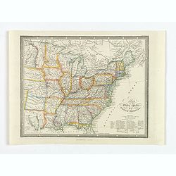
Map of the United States of North America.
A detailed map of the U.S. published at the end of the American Civil War in London by James Wyld. Each state is colored differently, rivers, major settlements and native...
Place & Date: London, ca 1865
Selling price: $150
Sold in 2020
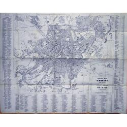
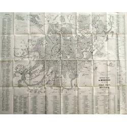
Guide du Voyageur (with rare large plans of Moscow)
French travel guide of St. Petersburg with the large and very rare town-plan of Moscow! "Nouveau Plan de Moscou avec Environs" published by Hoppe in 1867. The ...
Place & Date: Paris, 1866
Selling price: $350
Sold in 2012
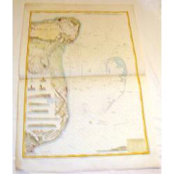
Angleterre Cote S.E., Rade des Dunes.
Informative sea chart featuring the coast of England from Margate to Dover with miniatrure city plans of Deal and Ramsgate in between. Miniature colored pictures of ligh...
Place & Date: Paris, 1866
Selling price: $99
Sold in 2015

Paris fashion plate. (593)
From Les Modes Parisiennes. Underneath the print are the names of the shops where the clothing's, perfumes, porcelains, flowers, etc., depicted in the engraving, are to b...
Place & Date: Paris, 1866
Selling price: $20
Sold in 2019

Paris fashion plate. (594)
From Les Modes Parisiennes. Underneath the print are the names of the shops where the clothing's, perfumes, porcelains, flowers, etc., depicted in the engraving, are to b...
Place & Date: Paris, 1866
Selling price: $10
Sold in 2022

Paris fashion plate. (666)
From Les Modes Parisiennes. Underneath the print are the names of the shops where the clothing, perfumes, porcelains, flowers, etc., depicted in the engraving, are to be ...
Place & Date: Paris, 1866
Selling price: $7
Sold in 2022

Paris fashion plate. (127)
From Les Modes Parisiennes. Underneath the print are the names of the shops where the clothing's, perfumes, porcelains, flowers, etc., depicted in the engraving, are to b...
Place & Date: Paris, 1866
Selling price: $20
Sold in 2019

Paris fashion plate. (905)
From Les Modes Parisiennes. Underneath the print are the names of the shops where the clothing's, perfumes, porcelains, flowers, etc., depicted in the engraving, are to b...
Place & Date: Paris, 1866
Selling price: $12
Sold in 2022

Paris fashion plate. (576)
From Les Modes Parisiennes. Underneath the print are the names of the shops where the clothing's, perfumes, porcelains, flowers, etc., depicted in the engraving, are to b...
Place & Date: Paris, 1866
Selling price: $20
Sold in 2013

Paris fashion plate. (572)
From Les Modes Parisiennes. Underneath the print are the names of the shops where the clothing's, perfumes, porcelains, flowers, etc., depicted in the engraving, are to b...
Place & Date: Paris, 1866
Selling price: $10
Sold in 2022

Paris fashion plate. (567)
From Les Modes Parisiennes. Underneath the print are the names of the shops where the clothing's, perfumes, porcelains, flowers, etc., depicted in the engraving, are to b...
Place & Date: Paris, 1866
Selling price: $10
Sold in 2022

Paris fashion plate. (617)
From Les Modes Parisiennes. Underneath the print are the names of the shops where the clothing's, perfumes, porcelains, flowers, etc., depicted in the engraving, are to b...
Place & Date: Paris, 1866
Selling price: $20
Sold in 2019

A set of 15 humorous prints. 1846, 1856, 1862, 1863, 1864, 1865, 1866. All with American, Civil War, Oregon Treaty and Abraham Lincoln interest
A set of 15 humorous prints. 1846, 1856, 1862, 1863, 1864, 1865, 1866. All with American, Civil War, Oregon Treaty and Abraham Lincoln interest.Mostly engraved by Sir Joh...
Place & Date: London, 1846 - 1866
Selling price: $65
Sold in 2015
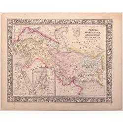
Map of Persia, turkey in Asia,,Afghanistan, Beloochistan.
An example of the beautiful maps of Augustus Mitchell. This map covers the modern day countries of Turkey, Iran, Iraq, Syria, Jordan and Afghanistan. There is an inset of...
Place & Date: New York, 1866
Selling price: $15
Sold in 2016
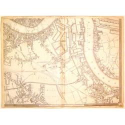
London, (South East Sheet).
Large handsome map of mid-Victorian South East London, including Southwark, Bermonsey, Surrey Docks, Depford and western Isle of Dogs. Published by Cassell, Petter & ...
Place & Date: London, 1866
Selling price: $55
Sold in 2019

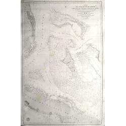
Chart of the North Sea Comprising All the Modern Surveys Drawn by J.S. Hobbs.
A fine antique working nautical chart of the North Sea by Norie, published in London in 1866. It was published by Charles Wilson (Late J.W. Norie and Wilson). The seller...
Place & Date: London, 1866
Selling price: $450
Sold in 2018
Carta del gran banco de Bahama parte de la isla de Cuba y costa de la Florida.
A scarce chart of the Bahamas, from Grand Bahama to Cuba and from Florida to the Exumas. In Florida it shows Fort Jupiter, Boca Raton, Miami, Jessup, Fort Lauderdale, etc...
Place & Date: Madrid, 1866
Selling price: $700
Sold in 2020
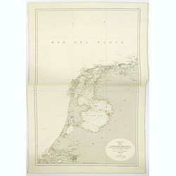
Mar de la Norte, Carta de la Costa de Holanda. . .
A large sea chart, published in Madrid of part of the coast of Holland. The chart extends from Borkum in Lower Saxony in Germany in the north, south to Brouwershaven in Z...
Place & Date: Madrid, 1866
Selling price: $85
Sold in 2019
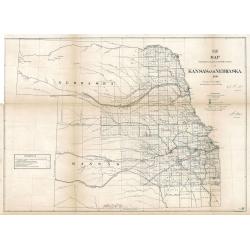
Map Showing the progress of the Public surveys in Kansas and Nebraska
An impressive and important early land survey of Kansas and the Nebraska Territory immediately following the Civil War when America set its sight back on the western fron...
Place & Date: Philadelphia, 1866
Selling price: $450
Sold in 2023

Paris fashion plate. (597)
From Les Modes Parisiennes. Underneath the print are the names of the shops where the clothing's, perfumes, porcelains, flowers, etc., depicted in the engraving, are to b...
Place & Date: Paris, 1866
Selling price: $15
Sold in 2015

Paris fashion plate. (600)
From Les Modes Parisiennes. Underneath the print are the names of the shops where the clothing's, perfumes, porcelains, flowers, etc., depicted in the engraving, are to b...
Place & Date: Paris, 1866
Selling price: $15
Sold in 2015

Paris fashion plate. (604)
From Les Modes Parisiennes. Underneath the print are the names of the shops where the clothing's, perfumes, porcelains, flowers, etc., depicted in the engraving, are to b...
Place & Date: Paris, 1866
Selling price: $10
Sold in 2023

Paris fashion plate. (611)
From Les Modes Parisiennes. Underneath the print are the names of the shops where the clothing's, perfumes, porcelains, flowers, etc., depicted in the engraving, are to b...
Place & Date: Paris, 1866
Selling price: $20
Sold in 2015
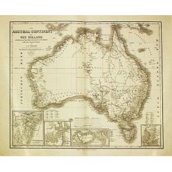
Das Austral Continent oder Neu Holland.
A map of the Australian continent with insets showing N.S.Wales, Sydney, Melville Island and Adelaide.
Place & Date: Wimar, 1866
Selling price: $160
Sold in 2009

Paris fashion plate. (662)
From Les Modes Parisiennes. Underneath the print are the names of the shops where the clothing's, perfumes, porcelains, flowers, etc., depicted in the engraving, are to b...
Place & Date: Paris, 1866
Selling price: $30
Sold in 2023

Paris fashion plate. (653)
From Les Modes Parisiennes. Underneath the print are the names of the shops where the clothing's, perfumes, porcelains, flowers, etc., depicted in the engraving, are to b...
Place & Date: Paris, 1866
Selling price: $21
Sold in 2013

Plage de Scheveningen.
Attractive lithography showing a typical Dutch beach scene at Scheveningen in the middle of the 19th century, lithographed by Cleman after a painting by Nuyen. Published ...
Place & Date: The Hague, c.1867
Selling price: $50
Sold
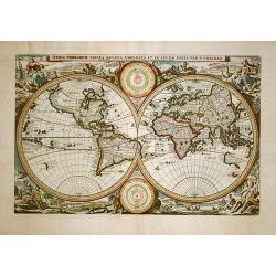
Orbis Terrarum Tabula Recens..
This is a very unusual nineteenth century edition of one of the most popular world maps of the seventeenth century. First produced in 1663, this map appeared in a Dutch b...
Place & Date: Amsterdam, 1867
Selling price: $650
Sold in 2008

Mer des Antilles. Carte des passages entre Cuba, La Jamaique et la cote des mosquitos. . .
Detailed centered on Jamaica and the Cayman Islands. Engraved by Chassant and the text by Carré. Lighthouse have a yellow/red dot and additional red printed explanation...
Place & Date: Paris, 1867
Selling price: $50
Sold in 2018

Mapa fisica y politica de la América del Sur. . .
Large and uncommon lithographed map of South America prepared by A.Vuillemin and A.Logerot and printed by Gratia. Most names in Spanish. In lower right corner an inset ma...
Place & Date: Paris, A.Logerot / F.Brachet, 1867
Selling price: $600
Sold in 2011

Nouvelle carte du royaume d'Italie indiquant les nouvelles divisions politiques. . . Nouvelle edition.
Large post road maps map of Italy and Central Europe published by A.Logerot. According to a text in lower part "Les eaux gravées à la méganique par M.me Fontaine&...
Place & Date: Paris, c.1867
Selling price: $96
Sold in 2023
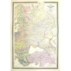
Carte de la Russie d'Europe et de la Turquie Théàtre de la Guerre en Oriens. . .
Very large, highly detailed and uncommon issue of the map by Brué depicting the progress of the war in the Ukraine, the Crimea and the Black Sea. Including Istanbul and ...
Place & Date: Paris, London, ca. 1867
Selling price: $400
Sold in 2013
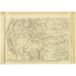
Map Showing the Scene of General Hancocks Operations in the Indian Country, the Forts, military stations, Pacific railroads etc.
A full-page map from Harper's Weekly that is very well engraved and detailed considering it is from a weekly newspaper. The subject of the map is General Hancock's operat...
Place & Date: New York, 1867
Selling price: $50
Sold in 2012
Guide du Voyageur en Russie (with plans of St. Petersburg, Moscow, and a map of Russia)
French travel guide to St. Petersburg with two large and very rare town-plans of St. Petersburg and Moscow! "Nouveau Plan de St. Petersbourg avec Environs" and...
Place & Date: Paris, 1867
Selling price: $1150
Sold in 2012

Johnson's Australia and East Indies
Very attractive and large map of Australia, the East Indies and Southeast Asia. Extends from Thailand and Vietnam, south to include all of the East Indies, the Philippine...
Place & Date: New York, 1867
Selling price: $110
Sold in 2012

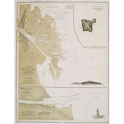
Brazos Santiago, Texas
Completed chart. Area of Padro Island.Brazos Island has a hospital and barracks shown.Quite interesting for this area and time. Dated in plate. Needs bottom re-margining.
Place & Date: 1867
Selling price: $30
Sold in 2016

A Bibliographical and Historical Essay on the Dutch Books relating to New Netherland... Dutch West India Company...
This is the rare original edition of Ashers important reference work. With the large folding map "Novi Belgii..." after Visscher.Additional shipping costs apply...
Place & Date: Amsterdam, 1867
Selling price: $400
Sold in 2019
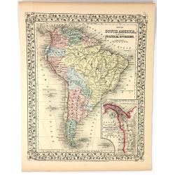
Map of South America Showing its Political Divisions
A pleasing map of South America, with attention to both political and geographical elements. Complete with inset of the Atrato-Inter-Oceanic Canal Routes. The map is sur...
Place & Date: Philadelphia, 1867
Selling price: $20
Sold in 2016

Singsing Town of Ossining, Westchester Co. N.Y.
Fine lithographed map of Sing Sing and Ossining New York. The map provides the names of specific homeowners, as well as information about the occupations and physical loc...
Place & Date: New York, 1867
Selling price: $200
Sold in 2019

Mamaroneck, Scarsdale, White plans, Harrison & Rye.
Fine lithographed map of Mamaroneck, Scarsdale, White plans, Harrison & Rye. The map provides the names of specific homeowners, as well as information about the occup...
Place & Date: New York, 1867
Selling price: $90
Sold in 2019

Mamaroneck.
Fine lithographed map of Mamaroneck. The map provides the names of specific homeowners, as well as information about the occupations and physical locations of the various...
Place & Date: New York, 1867
Selling price: $75
Sold in 2019
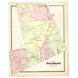
Town of Poundridge.
Fine lithographed map of the town of Poundridge. The map provides the names of specific homeowners, as well as information about the occupations and physical locations of...
Place & Date: New York, 1867
Selling price: $90
Sold in 2017

Port Chester.
Fine lithographed map of Port Chester. The map provides the names of specific homeowners, as well as information about the occupations and physical locations of the vario...
Place & Date: New York, Beers, Ellis, & Soule, 1867
Selling price: $60
Sold in 2016

Plan of New York and Brooklyn.
Fine lithographed map of New York and Brooklyn. The map provides the names of specific homeowners, as well as information about the occupations and physical locations of ...
Place & Date: New York, 1867
Selling price: $100
Sold in 2017
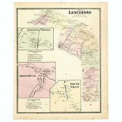
Town of Lewisboro.
Fine lithographed map of the town of Lewisboro. The map provides the names of specific homeowners, as well as information about the occupations and physical locations of ...
Place & Date: New York, 1867
Selling price: $90
Sold

Plans of Westchester, West Farms, Morrisania . . .
Fine lithographed map of Westchester, West Farms, Morrisania. The map provides the names of specific homeowners, as well as information about the occupations and physical...
Place & Date: New York, 1867
Selling price: $90
Sold in 2018
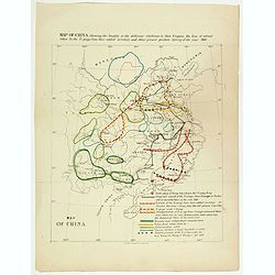
Map of China showing the locality of the different rebellions in that Empire, the line of retreat taken by the Ti-pings from their settled territory, and their present position Spring of the year 1866.
Map of China showing the locality of the different rebellions in that Empire, the line of retreat taken by the Ti-pings from their settled territory, and their present po...
Place & Date: London, circa 1867
Selling price: $230
Sold in 2017
![[Official US Government Document.]](/uploads/cache/48158-250x250.jpg)
[Official US Government Document.]
An official US government printed document, completed in manuscript. An attractive engraved broadside, signed by President Andrew Johnson appointing John G. Chandler with...
Place & Date: Washington D.C., 1867
Selling price: $350
Sold in 2022

The Bouquet of Sydney.
An unusual view of Sydney on an envelope! This small but detailed image of the city shows the harbour with many ships and people in the foreground. With gold printed fram...
Place & Date: Hamburg, ca. 1868
Selling price: $80
Sold in 2020
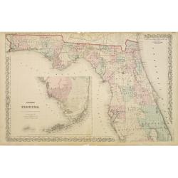
Colton's Florida.
With inset map of the southern part of Florida. Extremely detailed map (scale 1:140.000). On verso one page of text with a wealth of geographical information.
Place & Date: New York, 1868
Selling price: $100
Sold in 2009
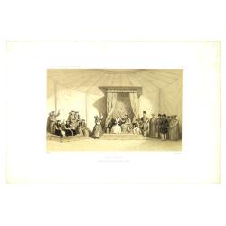
Danse Kalmouke sous la tente de la Princesse Tumêne.
Lithography from a rare book by Hommaire-de-Hell "Voyage à la mer Caspienne". Ignace-Xavier Morand Hommaire-de-Hell (1812-1848) was a traveler and geologist, w...
Place & Date: Paris, Lemercier, 1868
Selling price: $50
Sold in 2010
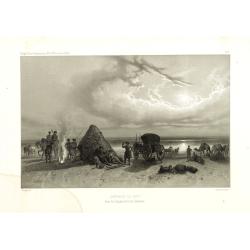
Campement de nuit dans les steppes de la mer Caspienne. Voyage à la mer Caspienne par Mr et Mme Hommaire de Hell.
Lithography after a design by Gluck of a Kalmouk Buddhist Temple in the Republic of Kalmykia, the only Buddhist region in Europe. Lithography taken from "Voyage à l...
Place & Date: Paris, Lemercier, 1868
Selling price: $50
Sold in 2011

Temple Kalmouk sur la rive gauche du Volga. Voyage à la mer Caspienne par Mr et Mme Hommaire de Hell.
Lithography after a design by Gluck of a Kalmouk Buddhist Temple in the Republic of Kalmykia, the only Buddhist region in Europe. Lithography taken from "Voyage à l...
Place & Date: Paris, Lemercier, 1868
Selling price: $150
Sold in 2014
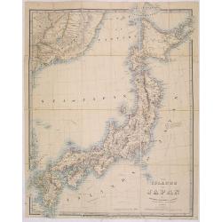
The islands of Japan by James Wyld..
Very detailed map of Japan, including part of the coast of Korea with Busan harbor. Including tracks of explorers, Krusenstern (1804), Providence (1796), Argonaut (1797),...
Place & Date: London, 1868
Selling price: $500
Sold in 2013
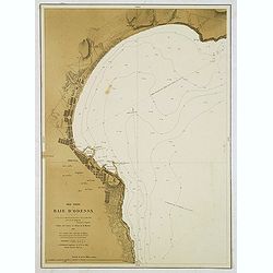
Mer Noire - Baie d'Odessa. . .
Detailed chart of the Bay and town of Odessa in the Ukraine. With soundings. According to the title the chart is copied from a Russian map made by Lieut. Belgavski. The c...
Place & Date: Paris, 1869
Selling price: $120
Sold in 2012
Mer Noire. Danube Bouches de la Branche Kilia. / Branche Sulina (Danube).
Two very detailed charts of the outlet of the Danube River into the black Sea. In upper right corner inset map of "Ilan Ada st ou Fido-Nisi ou Ile aux serpents. . . ...
Place & Date: Paris, after 1869
Selling price: $150
Sold
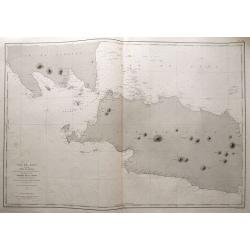
Ile de Java 1ère Feuille Partie Occidentale. . .
Large size sea-chart of the Sunda Strait. Shows parts of Sumatra and Java (extending east until Cirebon). With numerous small islands shown, depth soundings and anchoring...
Place & Date: Paris, 1869
Selling price: $145
Sold in 2014

Ile de Java 2ème Feuille Partie Centrale. . .
Large size sea-chart of central Java. Extends from Indramayu until Madura. Includes Karimunjawa and Bawean in great detail. With depth soundings and anchoring places. Onl...
Place & Date: Paris, 1869
Selling price: $85
Sold in 2014
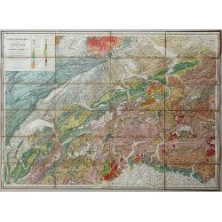
Carte Geologique de la Suisse de M.M.B. Studer et A. Escher von der Linth. 2nd Edition revue et corrigée d'après les publications récentes et les communications des auteurs et de M.M. v. Fritsch, Gilleron, Jaccard, Kaufmann, Mösch, Müller, Stoppani, Théob
Lithographic map, dissected and laid on linen as issued. When folded the map is protected by two contemporary "leather" covers with the title imprinted in gold....
Place & Date: Winterthur, 1869
Selling price: $201
Sold in 2020

Paris fashion plate.
"From Le Mode Elégant.A attractive print from a 19th century Paris women's magazine. These periodicals, whose circulation in great numbers, created height...
Place & Date: Paris 1869
Selling price: $16
Sold in 2009

Paris fashion plate.
"From Le Mode Elégant.A attractive print from a 19th century Paris women's magazine. These periodicals, whose circulation in great numbers, created height...
Place & Date: Paris 1869
Selling price: $16
Sold in 2009
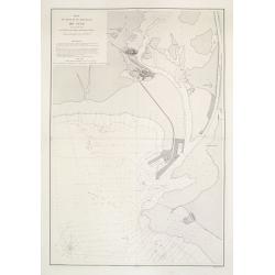
Plan du Port et du Mouillage de Suez..
A very detailed and historically important of the Suez bay showing a plan of the town Suez, and the entry of the Suez canal. The map is updated to August 1869, only a fe...
Place & Date: Paris, 1869
Selling price: $300
Sold in 2012
![[2 sheets] Cartes du Canal de Suez.. 1ère Partie. De Port-Saïd a Kantara. 2ème Partie. De Kantara aux Lacs Amers./ 3ère Partie. De L'Entrée Nord Dans Les Lacs Amers A Suez.](/uploads/cache/23502-250x250.jpg)
[2 sheets] Cartes du Canal de Suez.. 1ère Partie. De Port-Saïd a Kantara. 2ème Partie. De Kantara aux Lacs Amers./ 3ère Partie. De L'Entrée Nord Dans Les Lacs Amers A Suez.
A set of two detailed charts: The first and second part on one sheet illustrating 2 parts of the Suez Canal and its surroundings, from Port Said to Al Qantarah and from t...
Place & Date: Paris, 1869
Selling price: $300
Sold in 2012
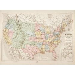
Carte physique et politique des États-Unis..
Very detailed map of the United States. In lower right inset maps of the Great Lakes and the River Niagara.Engraved by Th.Gobert and Langevin. Included in Atlas Général...
Place & Date: Paris, 1870
Selling price: $150
Sold in 2014
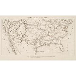
États-Unis D'Amérique.
Rare map of the United States showing the existing roads, the existing roads owned by the Compagnie Transcontinentale Memphis-Pacific and the planned roads of the same co...
Place & Date: Paris 1870
Selling price: $37
Sold

Harbour at Concarneau.
Etching of a landscape with the harbour of Concarneau, signed Lalanne.Early state, with the the erasion of the original "Trouville" at bottom right. Still wrong...
Place & Date: France ca. 1870
Selling price: $100
Sold

Infanterie de ligne.
A very decorative lithography of soldiers from about 1804.
Place & Date: France, c.1870
Selling price: $30
Sold in 2023

NEW ORLEANS
A handsome panorama of New Orleans as seen in the late 1830's. Perhaps the finest view of the city produced during the 19th century. Several key sites are depicted along ...
Place & Date: New York, c. 1870
Selling price: $80
Sold
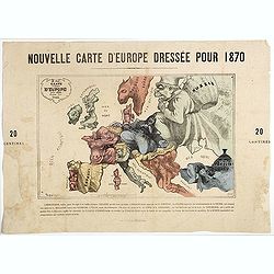
Nouvelle Carte d'Europe dressée pour 1870 / Carte drôlatique d'Europe pour 1870 dressée par Hadol.
Satirical illustration by Paul Hadol showing disposition of power in Europe at the beginning of 1870. Satirical print depicting a map of Europe in which the countries are...
Place & Date: Paris, Imprimerie Vallée, 1870
Selling price: $900
Sold

Land Verhuizing naar Canada..
A rare pamphlet in order to stimulate immigration of Belgium farmers to the province of Quebec.In top two maps, one of western Europe and one of eastern Canada. The pamph...
Place & Date: Antwerp c.1870
Selling price: $140
Sold
![[Interior with wallmap.]](/uploads/cache/25617-250x250.jpg)
[Interior with wallmap.]
Scene of a painter and his model set in an old Dutch interior with a wall map of Holland in the back. Etching by Willem Unger after a painting by Joannes Vermeer.Many sev...
Place & Date: Amsterdam, c. 1870
Selling price: $160
Sold in 2008
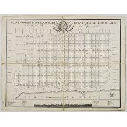
Plano Topografico de las Calles de la Ciudade de Buenos-Aires. . .
Folding-map of Buenos Aires Inset of the city sky line with a key map.
Place & Date: ca. 1870
Selling price: $500
Sold in 2008

Cartes des Alpes Maritimes Littoral de la Méditerranée aux environs de Fréjus, Cannes, Grasse, Antibes, Nice, Monaco et Menton.
Folding-map of the Maritime Alps and the Mediterranean coastline of Fréjus, Cannes, Grasse, Antibes, Nice, Monaco, and Menton. Engraved by Erhard, geographer and engrave...
Place & Date: Paris, 1870
Selling price: $80
Sold in 2008
![[untitled map of Japan]](/uploads/cache/91045-250x250.jpg)
[untitled map of Japan]
Superb 19th century woodblock printed map of Japan. Very large size and scale, with excellent detail. Strikingly decorative and skillfully executed. With nice hand-colori...
Place & Date: Japan, c1870
Selling price: $1000
Sold in 2010
![[Europe, Africa and North America].](/uploads/cache/25707-250x250.jpg)
[Europe, Africa and North America].
The upper right sheet of a four sheet folding world map. Showing Europe, with an inset with the British Islands, the eastern half of North America and the Caribbean. Incl...
Place & Date: Paris, J.Dumaine, c.1870
Selling price: $30
Sold in 2018
![[Oceanie and Untitled States].](/uploads/cache/25708-250x250.jpg)
[Oceanie and Untitled States].
The lower left sheet of a four sheet folding world map. Showing Oceania with an inset map of the United States. The Pacific Ocean is filled with shipping routes of the di...
Place & Date: Paris, J.Dumaine, c.1870
Selling price: $100
Sold in 2011
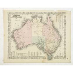
Johnson's Australia by Johnson and Ward.
A beautiful example of A. J. Johnson’s later map of Australia much detail marked in the interior. North Australia instead of Northern Territory. Tables in the corners s...
Place & Date: M. McDouall Stuart, Burke and Wills, New York, c. 1870
Selling price: $50
Sold in 2012

Special-Karte der Eisenbahn- Post- u. Dampfschiff-Verbindungen Mittel-Europa's - mit Angabe aller Eisenbahn-, Post- u. Dampfschiffstationen, Speditionsorte, Zoll- u. Steuerämter, Bäder, Mineralquellen
Gigantic wall map of Central Europe showing rail way, post routes and ship routes, prepared by C.J.C. Raab and edited by H. Müller. More about folding maps. [+]
Place & Date: Glogau, C.Flemming, 1870
Selling price: $300
Sold in 2017
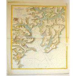
Angleterre Cote Sud, Port du Falmouth.
Striking lithographed sea chart of the Port of Falmouth in England. Depôt des Cartes et Plans de la Marine (1720 - present), often called the Depôt de Marine, was a Fr...
Place & Date: Paris, 1870
Selling price: $79
Sold in 2015