Browse Listings
Isles Britanniques carte des chemins de fer et canaux.
Very detailed map from Atlas Sphéroïdal & Universel de géographie , Prepared by F.A.Garnier and edited by Jules Renouard, rue de Tournon, Paris. Uncommon map with ...
Place & Date: Paris, 1861
Selling price: $135
Sold in 2011
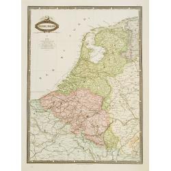
Belgique & Hollande.
Very detailed map from Atlas Sphéroïdal & Universel de géographie. Prepared by F.A.Garnier and edited by Jules Renouard, rue de Tournon, Paris. Uncommon map with d...
Place & Date: Paris 1861
Selling price: $100
Sold in 2020
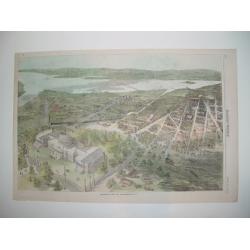
Balloon view of Washington, D. C.
An impressive wood cut balloon view of Washington, D. C. at the start of the American Civil War. The Capitol is seen in the foreground, with its dome under construction. ...
Place & Date: New York, 1861
Selling price: $160
Sold
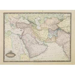
Asie Occidentale. Turquie..Arabie, Perse, Turkestan..
Very detailed map from Atlas Sphéroïdal & Universel de géographie. Prepared by F.A.Garnier and edited by Jules Renouard, rue de Tournon, Paris. Uncommon map with d...
Place & Date: Paris, 1861
Selling price: $85
Sold in 2011
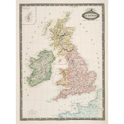
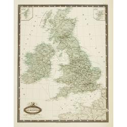
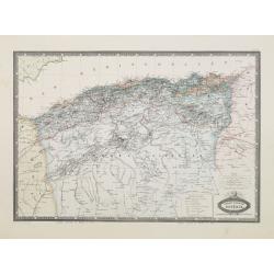
Isles Britanniques, Angleterre, Ecosse, Irlande. . .
Very detailed map from Atlas Sphéroïdal & Universel de géographie, Prepared by F.A.Garnier and edited by Jules Renouard, rue de Tournon, Paris. Uncommon map with d...
Place & Date: Paris, 1861
Selling price: $100
Sold in 2011

Abraham Lincoln. Président des Ëtats-Unis.
Very fine steel engraving of Abraham Lincoln. Engraved in steel by Carl Mayer.
Place & Date: c. 1861
Selling price: $35
Sold

Atlas zu Alexander von Humboldt's Kosmos.
Folio, oblong. In the original 8 instalments, in original covers (sl. dam.). With 39 col. maps and 3 tables with 31 steelengravings. In new slipcase.The popular edition o...
Place & Date: Stuttgart, T. Bromme, 1860-1861
Selling price: $1150
Sold

Afrique spheroidale..
Very detailed map from Atlas Spherodidal & Universel de géographie , Prepared by F.A.Garnier and edited by Jules Renouard, rue de Tournon, Paris. Uncommon map with d...
Place & Date: Paris 1861
Selling price: $180
Sold
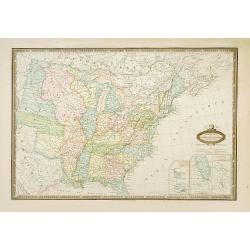
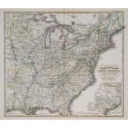
États-Unis de L'Amérique du Nord..
Very detailed map from "Atlas Spherodidal & Universel de geographie", Prepared by F.A.Garnier and edited by Jules Renouard, rue de Tournon, Paris. Uncommon ...
Place & Date: Paris, 1861
Selling price: $180
Sold

Amérique Boréale, Nouv.le-Bretagne & Canada.
Very detailed map from Atlas Sphérodoïdal & Universel de géographie , Prepared by F.A.Garnier and edited by Jules Renouard, rue de Tournon, Paris. Uncommon map wit...
Place & Date: Paris, 1861
Selling price: $90
Sold in 2016
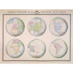
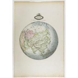
Tableau synoptique de la sphericite de la Terre,. . .
Very unusual map showing six globe-projections. From Atlas Sphérodïdal & Universel de géographie , prepared by F.A. Garnier and edited by Jules Renouard, rue de To...
Place & Date: Paris, 1861
Selling price: $160
Sold in 2014

Suisse.
Very detailed map from Atlas Sphéroïdal & Universel de géographie , Prepared by F.A.Garnier and edited by Jules Renouard, rue de To...
Place & Date: Paris, 1861
Selling price: $50
Sold in 2010
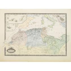
Afrique Septentrionale, Maroc, Algerie.. Canaries..Malte.
Very detailed map from Atlas Sphérodoïdal & Universel de géographie , Prepared by F.A.Garnier and edited by Jules Renouard, rue de Tournon, Paris. Uncommon map wit...
Place & Date: Paris 1861
Selling price: $160
Sold
Afrique Francaise. Algerie.
Very detailed map from Atlas Sphérodoïdal & Universel de géographie , Prepared by F.A.Garnier and edited by Jules Renouard, rue de Tournon, Paris. Uncommon map wit...
Place & Date: Paris 1861
Selling price: $35
Sold
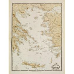
Carte Generale de L'Archipel.
Very detailed map from Atlas Sphéroïdal & Universel de géographie. Prepared by F.A.Garnier and edited by Jules Renouard, rue de Tournon, Paris. Uncommon map with d...
Place & Date: Paris, 1861
Selling price: $55
Sold in 2022
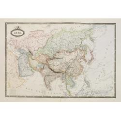
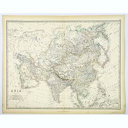
Asie.
Very detailed map from Atlas Sphéroïdal & Universel de géographie. Prepared by F.A.Garnier and edited by Jules Renouard, rue de Tournon, Paris. Uncommon map with d...
Place & Date: Paris 1861
Selling price: $150
Sold in 2008
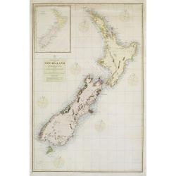
Pacific Ocean New Zealand
Large scale map of New Zealand from surveys by Captain J.L.Stokes, Commander B.Drury and G.H.Richards 1848-55. The chard was prepared in 1856 and corrected in 1858 and 18...
Place & Date: London, 1861
Selling price: $800
Sold

Turquie D'Asie Syrie, Liban. Region du Caucase.
Very detailed map from Atlas Sphérodïdal & Universel de géographie , Prepared by F.A.Garnier and edited by Jules Renouard, rue de Tournon, Paris. Uncommon map with...
Place & Date: Paris, 1861
Selling price: $100
Sold in 2008
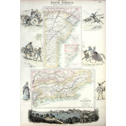
EAST COAST OF SOUTH AMERICA; BRAZIL, MIDDLE PROVINCES
Excellent lithograph published by Fullarton. Shows two maps of Brazil: "East Coast of Brazil" & "Province of Rio de Janeiro" both by H.Mahlmann a...
Place & Date: London, Edinburgh, Dublin, c.1861
Selling price: $35
Sold
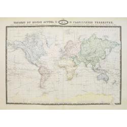
Tableau du Monde actuel ou planisphere Terestre,..
Very detailed world map in Mercator-projection, from Atlas Sphérodïdal & Universel de géographie. Prepared by F.A.Garnier and edited by Jules Renouard, rue de Tour...
Place & Date: Paris, 1861
Selling price: $160
Sold in 2011

Empire Romain
The Roman Empire, from Atlas Universel Physique, Historique, Politique de Géographie Ancienne et Moderne printed by Louis Antoine and published by Armand le Chevalier in...
Place & Date: Paris, 1861
Selling price: $15
Sold in 2011
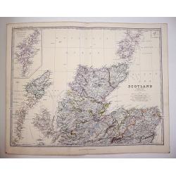
Scotland on Two sheets North and South
Scotland divided onto two large sheets. Scotland, northern sheet,page 7. by Keith Johnston, F.R.S.E. Engraved & printed by W. & A.K. Johnston, Edinburgh. William ...
Place & Date: Edinburgh, 1861
Selling price: $120
Sold in 2019

Europe.
Interesting map of Europe with its geography and territories around 1861! Published by Dufour. A large and detailed map with attractive coloring indicating the borders.
Place & Date: Paris, 1861
Selling price: $50
Sold in 2013
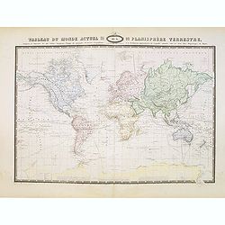
Tableau du Monde actuel ou planisphere Terestre,..
Very detailed world map in Mercator-projection, from Atlas Sphérodïdal & Universel de géographie , Prepared by F.A.Garnier and edited by Jules Renouard, rue de Tou...
Place & Date: Paris, 1861
Selling price: $100
Sold in 2014
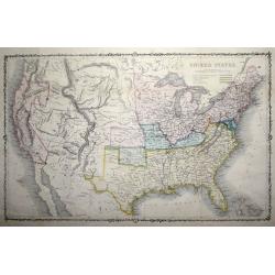
United States.
An uncommon pre-Civil War issue that was published by the London Printing and Publishing Company. Circa 1861.A highly detailed map which covers the entire country, issued...
Place & Date: London 1861
Selling price: $80
Sold in 2015

Six ethnographical maps illustrative of The Natural History of Man . . .
This atlas of six ethnographical maps were intended as a companion to Prichard's Natural History of Man, originally published in 1843, and the expanded five-volume editio...
Place & Date: London and New York: H. Baillière, 1861
Selling price: $1750
Sold in 2017
Asie spheroidale.
Very detailed map from Atlas Spherodidal & Universel de geographie , Prepared by F.A.Garnier and edited by Jules Renouard, rue de Tournon, Paris. Uncommon map in an u...
Place & Date: Paris, 1861
Selling price: $100
Sold in 2018

Asie Meridionale. Inde Anglaise et Indo-Chine.
Very detailed map from Atlas Spherodidal & Universel de geographie , Prepared by F.A.Garnier and edited by Jules Renouard, rue de Tournon, Paris. Uncommon map with de...
Place & Date: Paris, 1861
Selling price: $45
Sold in 2020

India (Southern Sheet).
A large and detailed steel engraved map sheet (1 of 2 only) of Southern India. Map extent is from Nagpur in the north to Ceylon (Sri Lanka) in the south. Regions are in d...
Place & Date: London, 1861
Selling price: $20
Sold in 2021
Asia.
A large, highly detailed map of the continent of Asia, from Johnston's General Atlas published around 1860 in Edinburgh. Various countries are highlighted in differing ou...
Place & Date: Edinburgh, ca 1861
Selling price: $60
Sold in 2020

Atlas Universel de Geographie Ancienne et Moderne. . .
FULL TITLE: Ambroise Tardieu. Atlas universel de géographie ancienne et moderne, dresse par Ambroise Tardieu, revu et corrige´par A. Vuillemin, pour l'intelligence de l...
Place & Date: Paris, 1861
Selling price: $160
Sold in 2019
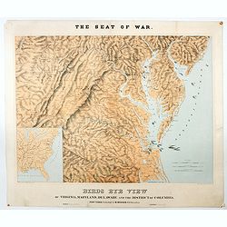
The Seat of War. Birds Eye View of Virginia, Maryland, Delaware and the District of Columbia.
A large and striking example of the seat of the civil war in the mid-Atlantic states in 1861. Extending from the southern reaches of New Jersey and Pennsylvania to northe...
Place & Date: New York, London, Paris, 1861
Selling price: $1150
Sold in 2020

Europe en 1789 (1861).
A large, highly significant and detailed map of Europe as it appeared in 1789 - on the very eve of the French revolution - something that would have a profound and lastin...
Place & Date: Paris, 1861
Selling price: $8
Sold in 2020
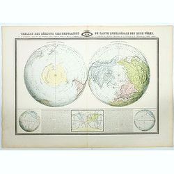
Tableau des regions circumpolaires..deux poles,..
A very detailed map showing the two polar-projections, in lower part of the map there are insets of the Atlantic Ocean, Pacific and a world map in Mercator projection. Ex...
Place & Date: Paris, 1861
Selling price: $150
Sold in 2021

Environs de Paris. Nouvel Atlas Topographique comprenant pour chaque Etat les villes d'industrie et de commerce, les places fortifiées, les chemins de fer, les canaux etc.
A bird's eye-view of Paris and vicinity by Guittet. Centered on Paris and the Seine River and including Versailles, St. Germain, Neuilly, Orly, etc.Paris, in pink, shown ...
Place & Date: Paris, ca. 1862
Selling price: $250
Sold in 2021
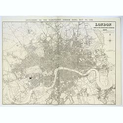
London Guide to the International Exhibition 1862
A very large and impressive plan of London, published specifically for the city's international exhibition of 1862. The exposition was a world's fair, seven years after t...
Place & Date: London, ca 1862
Selling price: $700
Sold
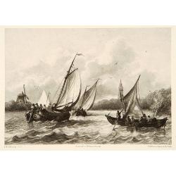
Shipping.
Attractive lithography showing Dutch vessels off the Dutch coast, by F.H.Weissenbruch after a painting by A.Waldorp. Published in "Kunst Kroniek".
Place & Date: The Hague, 1862
Selling price: $45
Sold in 2014

New Orleans
A desirable Civil War panoramic woodcut view of New Orleans. All major sites are depicted, including the Church of Saint Louis and French Quarter section. The city's harb...
Place & Date: New York, dated 1862
Selling price: $180
Sold in 2008
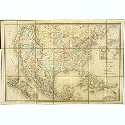
Carte Générale Des Etats - Unis Et Du Mexique Comprenant L'Amerique Centrale Et Les Antilles.
Large folding-map of the United States, Mexico and West Indies, with inset maps of Central America, Lesser Antilles, New York and Long Island, and the Atlantic connection...
Place & Date: Paris, 1862
Selling price: $500
Sold in 2019
Verein-Staaten von Nord-America . . .
General map of the United States of America with inset map of Texas. Very detailed map with a color key to American States.Published in Stieler's Hand Atlas.
Place & Date: Gotha, 1862
Selling price: $35
Sold in 2011
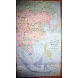
ASIE ORIENTALE comprenant L'EMPIRE CHINOIS ET LE JAPON LES ETATS DE L'INDO-CHINE ET LE GRAND ARCHIPEL D'ASIE
Early edition of the rare wall-map of the Far East by Andriveau-Goujon. Shows the Far East, from Russia, with Tibet, China, Korea, Thailand, Singapore, Indonesia, unti...
Place & Date: Paris, 1862
Selling price: $210
Sold in 2011

Carte de la République du Paraguay (cours du Parana et du Paraquay) . . .
Large, detailed and rare map of Paraguay prepared by Ernest Amédée Barthélemy Mouchez. According to the title the information was gathered during his voyages in 1857 -...
Place & Date: Paris, Logerot, 1862
Selling price: $600
Sold
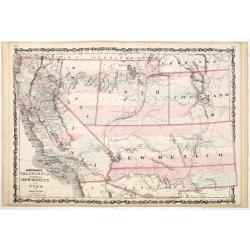
Johnson's California territories of New Mexico and Utah by Johnson and Ward.
Rare and important third state of the Johnson southwest map, now with a clearly defined Arrizona Territory. Published in 1862 at the height of the American Civil War, thi...
Place & Date: New-York, A. J. Johnson and Ward, 1862
Selling price: $170
Sold in 2014

Carte provisoire de la basse Cochinchine. Dressée par Ordre de Mr. le Vice Amiral Charner Commandant en Chef l'Escadre des Mers de Chine . . .
Map of Cochinchina prepared by L.Manen for the French Dépôt de la Marine. Engraved by Jacobs.Saigon is in the center. The map has red manuscript lines drawn in. In lowe...
Place & Date: Paris, 1862
Selling price: $100
Sold in 2015
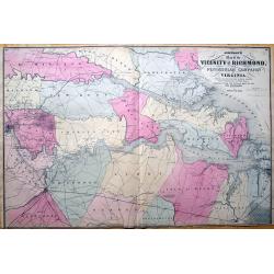
Johnson's Map of the Vicinity of Richmond, Peninsular Campaign in Virginia. Showing also the interesting localities along the James, Chickahominiy and York Rivers...
Important 1862 map of the vicinity of Richmond during the civil war. Shows the Union Advance during the Peninsular Campaign of the American Civil war.Highly detailed map,...
Place & Date: New York, 1862
Selling price: $30
Sold in 2013
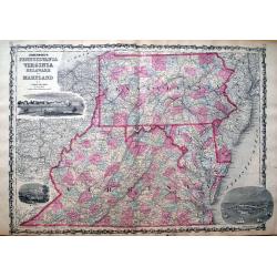
Johnson's Pennsylvania, Virginia, Delaware and Maryland.
Detailed map of Virginia, Maryland, Delaware and Pennsylvania, issued during the Civil War. The map pre-dates the formation of West Virginia and only appeared in the ear...
Place & Date: New York, 1862
Selling price: $35
Sold in 2013

Taureau Gascon
Representation of a bull from Gascon. Hand-colored heliogravure drawn by Emile Van Marcke after a photograph by Nadar, pseudonym of Gaspard Felix Tournachon, 1820-1910, F...
Place & Date: Paris, ca. 1861 - 1862
Selling price: $50
Sold in 2018

Vache d´Ayr.
Representation of an Obwalden bull. Hand-colored heliogravure drawn by Emile Van Marcke after a photograph by Nadar, pseudonym of Gaspard Felix Tournachon, 1820-1910, Fre...
Place & Date: Paris, ca. 1861 - 1862
Selling price: $50
Sold in 2018
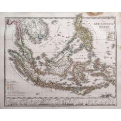
Die Ostindischen Inseln entw. u. gez. von F. v. Stülpnagel und Herm. Berghaus.
Superb map of Indonesia, filled with place names. Shows the area from Thailand to Papua New Guinea, including the Philippines, Singapore, Malaysia, Borneo, and the Indone...
Place & Date: Gotha, 1862
Selling price: $202
Sold in 2014
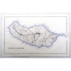
Island of Madeira.
Fine map of Madeira, one of the Portugese Islands in the Atlantic Ocean. Published by Fullerton & Company in 1862.
Place & Date: Edinburgh, 1862
Selling price: $19
Sold in 2016
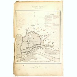
Prise de Canton 28 et 29 Décembre 1857.
A rare plan of Canton prepared by Captain Labbe. Plate II from "Atlas de l'expédition de Chine en 1860: rédigé au dépôt de la guerre d'après les documents offi...
Place & Date: Paris, 1862
Selling price: $250
Sold in 2018
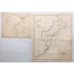
Reconnaissance of the Rebel Works at Gloucester Va. & Yorktown Va. (Two Maps)
Two fine maps of the “Reconnaissance of the Rebel Works” of Gloucester and Yorktown, Virginia. They were by Lieut. Comstock and Lieut. Abbot respectfully.They are qui...
Place & Date: New York, 1862
Selling price: $235
Sold in 2018
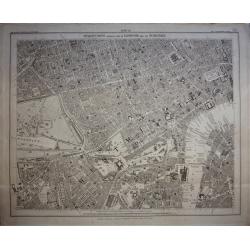
London. Guide to the International Exhibition.
Published as a supplement to the ILN of May 24th, 1862, this is a large, wonderfully detailed plan of London, extending from Hammersmith in the west, to Poplar in the eas...
Place & Date: London, 1862
Selling price: $210
Sold in 2017
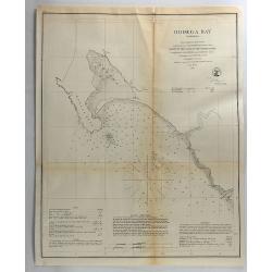
Bodega Bay, California.
Original lithograph of the U.S. Coast Survey map of Bodega Bay California from 1862.FULL TITLE : Bodega Bay California from a trigonometrical survey under the direction o...
Place & Date: Washington, 1862
Selling price: $14
Sold in 2018
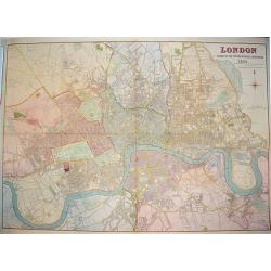
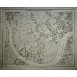
Stanford's Library Map of London and its Suburbs, sheet 10.
Published by Edward Stanford, 6 Charing Cross, London, February 15, 1862. Sheet no 10 covers the West End of London to the Houses Parliament and the Thames at Westminste...
Place & Date: London, 1862
Selling price: $240
Sold in 2020

Essai d'une carte géologique de l'Ile de Chypre.
Geological map of Cyprus prepared by Albert Gaudry (1827-1908), professor at Muséum d'histoire naturelle and member of the London Royal society of Sciences.A color key i...
Place & Date: Paris, 1862
Selling price: $600
Sold in 2017
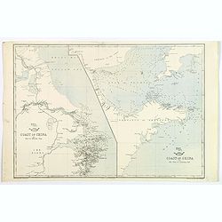
Coast of China. Nyew tew island to Hae Chow / Hae Chow to Leaotong Gulf.
A pair of coastal maps of China, published in the Weekly Dispatch Atlas circe 1862. The map information is mainly confined to the coast, but there is some detail inland a...
Place & Date: London, ca 1862
Selling price: $45
Sold in 2020
Stanford's Library Map of London and its Suburbs, sheet 13.
Published by Edward Stanford, 6 Charing Cross, London, February 15, 1862. Sheet no 13 covers West London... The Kings road in fields. The Thames from Hammersmith Bridge t...
Place & Date: London, 1862
Selling price: $260
Sold in 2019

Der Isthmus von Auckland Mit Seinen Erloschenen Vulkanegein.
Interesting map of Auckland isthmus with its extinct volcanoes. Published by Gotha Justus Perthes and printed in the Novara Expedition in 1859. THE HARBOURS AND BAYS OF ...
Place & Date: Gotha, 1862
Selling price: $45
Sold in 2019

New zealand middle & south islands. . .
Detailed map of New Zealand engraved by John Dower for "The Weekly Dispatch Atlas".
Place & Date: London, 1863
Selling price: $150
Sold in 2014
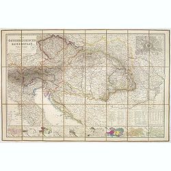
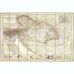
Der Osterreichische Kaiserstaat Entworfen von Herm. Berghaus. . .
Very detailed large-scale 19th century folding map of Austria, published in the birth year of Franz Ferdinand, became Archduke of Austria. Covers from Northern part of It...
Place & Date: Gotha, Justus Perthes, 1863
Selling price: $150
Sold in 2014
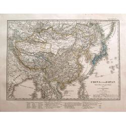
China und Japan. Entworfen und gezeichnet von F. von Stülpnagel. 1850 bereicht v. Herm. Berghaus.
Interesting and highly detailed map of the Far East, centered on China. Includes Japan, Taiwan, northern Philippines, Tibet, Mongolia, Nepal, parts of India, Myanmar, Tha...
Place & Date: Gotha, 1863
Selling price: $61
Sold in 2014

Australien und Polynesien in Mercators Projection.
Interesting and very detailed map of Australia and the Pacific Ocean, including a part of China, Japan, New Zealand, Hawaii, and a small part of California. With many sma...
Place & Date: Gotha, 1863
Selling price: $35
Sold in 2014
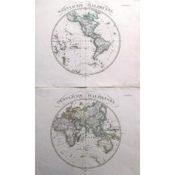
(2 maps) Westliche Halbkugel & Oestliche Halbkugel.
A fine pair of maps showing the two Hemispheres. Suggests an open North-West-Passage, and includes small parts of Antarctica. With large titles above the maps. Publishe...
Place & Date: Gotha, 1863
Selling price: $41
Sold in 2014
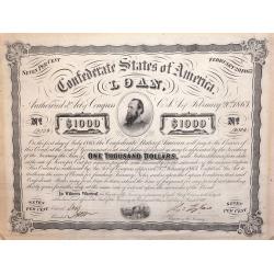
A Confederate States of America 1000 Dollar Loan Bond February 20th 1863.
American Civil War Bond of 1863, Low issue number, From the Confederate States of America 1000 Dollar Loan Bond: February 20th, 1863.With portrait of "Stonewall Jack...
Place & Date: Richmond, VA. ca. 1863
Selling price: $230
Sold in 2014

A set of 16 humorous woodblock prints from the Russian Empire's war with the French and British Empire's.
This set of 16 are from 1853 - 1863, mostly engraved by Joseph Swain. Joseph Swain was one of the most important woodblock engravers.Punch was responsible for the word se...
Place & Date: London, 1853 - 1863
Selling price: $100
Sold in 2015

A set of 16 humorous woodblock prints from the Russian Empire's war with the French and British Empire's.
This set of 16 are from 1853 - 1863, mostly engraved by Joseph Swain. Joseph Swain was one of the most important woodblock engravers. Punch was responsible for the word s...
Place & Date: London 1853 - 1863
Selling price: $100
Sold in 2015
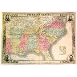
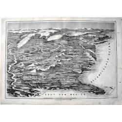
Map of the Southern States, Including Rail Roads, County Towns, State Capitals, County Roads, The Southern Coast From Delaware to Texas, Showing the Harbors, inlets, Forts and Position of Blockading Ships
Fine Harper's map of the South from Virginia and Florida to Kansas and Texas. The map features portraits of Lincoln, McClellan, Seward and Scott in the corners. Also a de...
Place & Date: New York, 1863
Selling price: $150
Sold in 2015
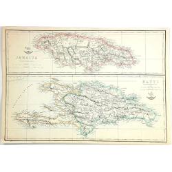
Jamaica & Hayti
Two maps on one sheet, the top showing Jamaica, and the bottom, the island of Haiti and Hispaniola. Published at the "Weekly Dispatch" Office in London in 1863...
Place & Date: London, 1863
Selling price: $5
Sold in 2016
![[4-sheets] Ireland.](/uploads/cache/39116-250x250.jpg)
[4-sheets] Ireland.
Large four-sheet map of Ireland by Edward Weller, published in the 'Dispatch Atlas'. Map consists of a N.E. sheet, a S.E. sheet, a N.W. sheet, which bears the title, and ...
Place & Date: London, 1863
Selling price: $36
Sold in 2017
![[4-sheets] Wales.](/uploads/cache/39117-250x250.jpg)
[4-sheets] Wales.
Large four-sheet map of Wales by Edward Weller, published in the 'Dispatch Atlas'.Map consists of a N.E. sheet, from Montgomeryshire up to the River Dee, a S.E. sheet fro...
Place & Date: London, 1863
Selling price: $16
Sold in 2017
![[4-sheets] Scotland.](/uploads/cache/39118-250x250.jpg)
[4-sheets] Scotland.
Large four-sheet map of Scotland by Edward Weller, published in the 'Dispatch Atlas'.Map consists of a N.W. sheet, from, the Western Isles, Skye, to parts of Ross and Sut...
Place & Date: London, 1863
Selling price: $35
Sold in 2017
![[4-sheets] England and Wales.](/uploads/cache/39119-250x250.jpg)
[4-sheets] England and Wales.
Large four-sheet map of England and Wales by Edward Weller, published in the 'Dispatch Atlas'.Map consists of a S.E. sheet, showing London and the 'Home Counties', a S.W....
Place & Date: London, 1863
Selling price: $25
Sold in 2017
Der Osterreichische Kaiserstaat Entworfen von Herm. Berghaus. . .
Very detailed large-scale 19th century folding map of Austria, published in the birth year of Franz Ferdinand, became Archduke of Austria. Covers from Northern part of It...
Place & Date: Gotha, Justus Perthes, 1863
Selling price: $205
Sold in 2023
Die Vereinigten Staaten von Amerika aus der Vogelschau.
From the "Illustrierte Zeitung", a rere map of the United States appeared in 1863. It shows the "sclaven Staaten" as well as the train roads. Rare
Place & Date: Germany, 1863
Selling price: $250
Sold in 2017
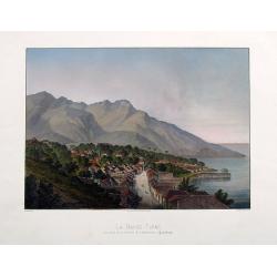
La Basse-Terre, vue prise de la Batterie de l'Impératrice, (Guadeloupe).
A fantastic view of the town from the rare and important series La Guadeloupe pittoresque by Armand Budan, published in 1863. Lithograph by Emile Vernier, and printed by...
Place & Date: Paris, 1863
Selling price: $100
Sold in 2017

Le Bourg de L'Anse Bertrand. Grand Terre (Guadeloupe).
A fantastic view of Anse-Bertrand, from the rare and important series La Guadeloupe pittoresque by Armand Budan, published in 1863. Lithograph by Emile Vernier, and print...
Place & Date: Paris, 1863
Selling price: $300
Sold in 2020

Vue du port et de la ville du Moule.
A fantastic view of Le Moule, from the rare and important series La Guadeloupe pittoresque by Armand Budan, published in 1863. Lithograph by Emile Vernier, and printed by...
Place & Date: Paris, 1863
Selling price: $300
Sold in 2020

Vue de la Souffrière prise de Versailles (Guadeloupe).
A fantastic view of the Soufrière volcano ,taken from the rare and important series La Guadeloupe pittoresque by Armand Budan, published in 1863. Lithograph by Emile Ver...
Place & Date: Paris, 1863
Selling price: $325
Sold in 2020
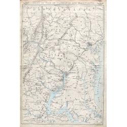
Seat of war in Virginia and Maryland.
An important and very detailed map of the District of Columbia, Eastern Maryland and Virginia. Extends from Gettysburg to Fredericksburg and Leonardtown, and includes str...
Place & Date: London, ca. 1863
Selling price: $25
Sold in 2018