Browse Listings

Atlas de Choix ou Recueil des Meilleures Cartes de Geographie Ancienne et Moderne.
Illustrated with 27 engraved single sheet maps and 33 double-page map sheets of which 7 are 2 or 4-sheet maps all with original hand-coloring. Including hand-colored tabl...
Place & Date: Paris, c. 1860
Selling price: $4200
Sold

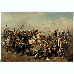
Colonel Mordaunt's Cock Match. At Lucknow in the Province of Oude in the Year 1786 at which were present several High and Distinguished Personages
An impression from the second half of the nineteenth century on wove paper first published as a hand-colored mezzotint by Earlom after Zoffany, Robert Sayer, London, 1792...
Place & Date: London, 1850-1860
Selling price: $200
Sold in 2016
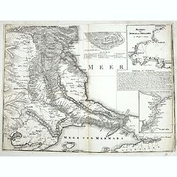
Meerbusen von Burgas oder Mesambri im Maasstab von 1:200.000. . . .
The lower part of a two-sheet map entitled "Karte der Hauptstraßen von der niederen Donau bis Constantinopel. . . ." The map has 4 insets with "Meerbusens...
Place & Date: Berlin, ca.1860
Selling price: $60
Sold in 2015
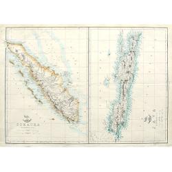
Sumatra; Java;
Two maps on one sheet. Both maps are highly detailed, filled with place names. The Sumatra map shows also Malaysia and Singapore. "The Weekly Dispatch" newspa...
Place & Date: London, ca. 1860
Selling price: $20
Sold in 2018

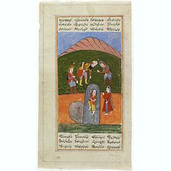
Manuscript page from a Shahnameh, The Book of Kings, written by Ferdowsi.
Page with large miniature 195 x 165mm. from the Shahnameh, or ("The Book of Kings"), which is a long epic poem written by the Persian poet Ferdowsi between c. 9...
Place & Date: Kashmir, ca. 1830-1860
Selling price: $325
Sold in 2016

Manuscript page from a Shahnameh, The Book of Kings, written by Ferdowsi.
Page with large miniature 160 x 160mm. from the Shahnameh, or ("The Book of Kings"), which is a long epic poem written by the Persian poet Ferdowsi between c. 9...
Place & Date: Kashmir, ca. 1830-1860
Selling price: $375
Sold in 2016
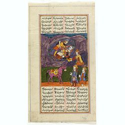
Manuscript page from a Shahnameh, The Book of Kings, written by Ferdowsi.
Page with large miniature 250 x 160mm. from the Shahnameh, or ("The Book of Kings"), which is a long epic poem written by the Persian poet Ferdowsi between c. 9...
Place & Date: Kashmir, ca. 1830-1860
Selling price: $325
Sold in 2016
Manuscript page from a Shahnameh, The Book of Kings, written by Ferdowsi.
Page with large miniature 185 x 160mm. from the Shahnameh, or ("The Book of Kings"), which is a long epic poem written by the Persian poet Ferdowsi between c. 9...
Place & Date: Kashmir, ca. 1830-1860
Selling price: $425
Sold in 2016

County Map of Nova Scotia, New Brunswick, Cape Breton Island and Prince Edward Island
A pleasing map of the Canadian Maritime Provinces, with attention to both political and geographical elements. Complete with inset of the city of Halifax. Map is surround...
Place & Date: Philadelphia, 1860
Selling price: $45
Sold in 2016
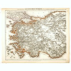
Specialkarte der Asiatischen Turkey : 1. Blatt Anadoli (Klein - Asien)
Steel engraved map of western part of Turkey, engraved by Ifslieb and J. Grassl for Druck u. Verlag des Bibliographischen Instituts in Hildburghausen, 1860.Included in &q...
Place & Date: Hildburghausen, 1860
Selling price: $50
Sold in 2016

Tasmania or Van Diemen's Island
A large and detailed lithographed map. It shows many towns, counties, rivers, and notes on the topography. Relief shown by hachures and spot heights. In the lower right-h...
Place & Date: London, ca. 1860
Selling price: $50
Sold in 2016

Paris sous Francois 1er. Vue générale à vol d'oiseau...
Fantastic color lithographed birds-eye view of Paris. Published by Charpentier in "Paris dans sa splendeur".
Place & Date: Paris, ca. 1860
Selling price: $65
Sold in 2016

(2 separate titles...) High Life & Low Life.
Two engravings by H Beckwith after Sir Edwin Landseer. Published by James S Virtue Each accompanied by a sheet of descriptive text
Place & Date: London 1860
Selling price: $60
Sold in 2018
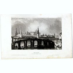
Moscau von der kreml-Seite.
View of Moscow with in the background the Kremlin. Original steel engraving, published by Bibliographisches Institut Hildburghausen.
Place & Date: Hildburghausen, ca. 1860
Selling price: $10
Sold in 2016
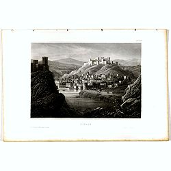
Tiflis.
View of Tiflis. Original steel engraving, published by Bibliographisches Institut Hildburghausen.
Place & Date: Hildburghausen, ca. 1860
Selling price: $10
Sold in 2020
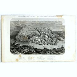
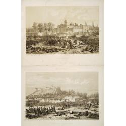
Plan of Attack & Defences of the South & North Sides of Harbour & Town of Sebastopol.
Scene during Crimean (Russo-Turkish) War 1853-1856. Bird's-eye plan of the harbour and town of Sebastopol Sevastopol) with the retreat of the Russians. Steel engraved pla...
Place & Date: London, James S Virtue, 1860
Selling price: $50
Sold in 2017

Etats-Unis, Region du Sud & Etats-Unis, Region du Nord (2 Maps).
A pair of chromo-lithograph maps featuring north and south United States. They are by A.H. Dufour and from "ATLAS POPULAIRE" published by Gustave Barba of Paris...
Place & Date: Paris , 1860
Selling price: $120
Sold in 2017
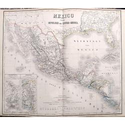
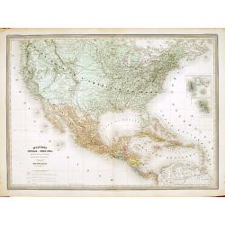
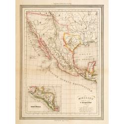
Mexico und die Republiken von Central-America.
Large and detailed map of Central America, Mexico and the contiguous parts of California, New Mexico, Texas and the very southern US. Two inset maps of the Tehuantepec an...
Place & Date: Weimar, ca. 1860
Selling price: $40
Sold in 2017

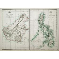
Borneo; The Philippine Islands;
Two maps on one sheet. Both maps are highly detailed, filled with place names.
Place & Date: London, ca. 1860
Selling price: $35
Sold in 2018
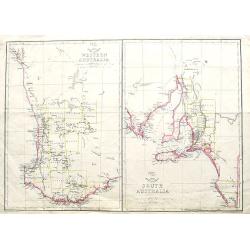
Western Australia; South Australia;
Two maps on one sheet. Both maps are highly detailed, with many place names. The maps show Perth, Adelaide, and Kangaroo Island. The Weekly Dispatch newspaper was publi...
Place & Date: London, ca. 1860
Selling price: $7
Sold in 2018
Map of the Great Salt Lake; The Great Salt Lake (Mormon) City;
Two important maps on one sheet showing Salt Lake City in Utah, and its surroundings. Both maps are very detailed, with many place names of rivers, settlements, springs, ...
Place & Date: London, ca. 1860
Selling price: $91
Sold in 2018

British Columbia (New Caledonia); Vancouver Island;
Two maps on one sheet. Both maps are very detailed, with many place names of rivers, islands, towns, forts, etc. The map of Vancouver shows the island in considerable sca...
Place & Date: London, ca. 1860
Selling price: $65
Sold in 2018
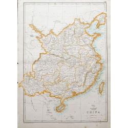
China.
A map of China and Taiwan, highly detailed, filled with place names.The Weekly Dispatch newspaper was published in London between the years 1856 and 1862, and included in...
Place & Date: London, ca. 1860
Selling price: $53
Sold in 2018
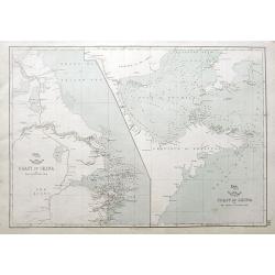
Coast of China. . .
Two charts on one sheet: The coast of China from Nyew tew Island to Hae-Chow; and the Coast of China from Hae-Chow to Leaotong Gulf. Both maps are highly detailed, filled...
Place & Date: London, ca. 1860
Selling price: $17
Sold in 2018
Lot of eleven chromolithographed plates showing Napoleon in Egypt.
Lot of 11 similar sheets with chromolithographed scene of "Battle of the Pyramids" after a painting of Antoine-Jean Gros.
Place & Date: France, ca. 1860
Selling price: $200
Sold in 2018
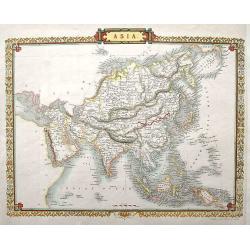
Asia.
Detailed steel engraved map by J. Rapkin, who also worked on the famous Tallis map. This map being almost identical to the Tallis version, only without the vignettes.
Place & Date: London, ca. 1860
Selling price: $37
Sold in 2018
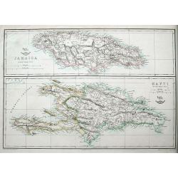
Jamaica; Hayti.
Two maps on one sheet, both very detailed with many place names, roads, hills, etc.The Weekly Dispatch newspaper was published in London between the years 1856 and 1862,...
Place & Date: London, ca 1860
Selling price: $25
Sold in 2018
Borneo; The Philippine Islands.
Two maps on one sheet. Both maps are highly detailed, filled with place names. The Philippines are shown from the Bashee Islands in the north to the Sooloo Archipelago in...
Place & Date: London, ca 1860
Selling price: $78
Sold in 2018
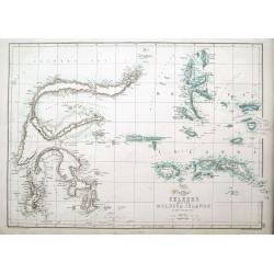
Celebes and the Molucca Islands.
A highly detailed map of the islands, also known as the Spice Islands, Celebes and Maluku Islands or the Moluccas, with many even small islands depicted. It depicts bays,...
Place & Date: London, ca 1860
Selling price: $20
Sold in 2018
South Africa.
An informative map of South Africa.
Place & Date: London, ca 1860
Selling price: $5
Sold in 2018

British settlements in the Malay peninsula and coast of Borneo . . .
Set of six little maps on one sheet, including a map of the Coast of Borneo, Singapore, Malacca, etc. Engraved by J. Bartholomew.
Place & Date: London, A.Fullarton, c. 1860
Selling price: $150
Sold in 2019

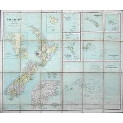
New Zealand.
An attractive map of New Zealand, with plenty of map detail, and a decorative Maori style border, by J.Rapin, closely based on those map published by his contemporary, Jo...
Place & Date: London, ca 1860
Selling price: $35
Sold in 2020
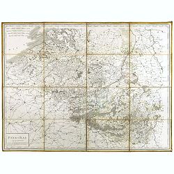
Pays-Bas en 4 Feuilles.
Uncommon map of present-day Belgium. Engraved by P.F.Tardieu. Text engraved by Aubertz.
Place & Date: Paris, 1860
Selling price: $50
Sold in 2019

Petit Atlas Elementaire.
A small French mid-nineteenth century atlas, complete with 8 double page maps: Mappe Monde (twin hemi), Europe, Europe Centrale, Asie, Afrique, Amerique (Nord et Sud), Oc...
Place & Date: Paris ca 1860
Selling price: $57
Sold in 2019
New Zealand.
An unusual folding map of New Zealand. With several insets of other islands including Hawaii, Society Islands, Galapagos, Fiji,... Also with a detailed map of Dunedin and...
Place & Date: London & Liverpool, ca. 1860
Selling price: $20
Sold in 2019
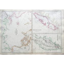
North Circumpolar regions / Vancouver Island / Kamtschatka.
Three maps on a douple page sheet. The maps are very detailed, with place names, rivers, islands, towns, forts, etc. The map of Vancouver shows the island in considerable...
Place & Date: Glasgow/Edinburgh/London, ca. 1860
Selling price: $30
Sold in 2019

Preussischer Staat.
Map of the Prussian state showing Posen, Pommern, Brandenburg, Sachsen, Westphalia, Rheinprovinz, Preussen. Nicely colored. Inset of Neufchatel, and a legend box.Cities s...
Place & Date: Glogau/Leipzig, ca 1860
Selling price: $50
Sold in 2019

Canada, New Brunswick, Nova Scotia, Cape Breton Island, Prince Edward Island and Newfoundland.
A fine, large, chromolithograph map of the Maritime provinces of Canada. Published by George Philip & Son of London in 1860 – 7 years before Canada was formed. New...
Place & Date: London, 1860
Selling price: $22
Sold in 2019
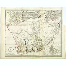
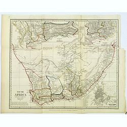
South Africa.
An informative map of South Africa, when it was under British influence. The various districts are highlighted in different outline colors mountains, rivers, coastal town...
Place & Date: London, ca 1860
Selling price: $25
Sold in 2022
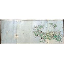
(untitled).
A Japanese woodblock map from the Edo period (1800-1868). It shows a part of the Kagoshima Prefecture on the island of Kyushu. An attractive and unusual map!
Place & Date: Japan, ca 1860
Selling price: $46
Sold in 2019

Sketch map of Nova Scotia showing the proposed line of the Nova Scotia eastern railway . . .
Lithograph map of Nova Scotia showing the proposed line of the Nova Scotia Eastern Railway.
Place & Date: London, ca. 1860
Selling price: $60
Sold in 2021
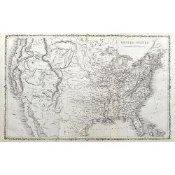
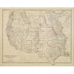
United States.
An unusual map of the United States. With excellent detail throughout. With "Indian Territory" north of Texas. Canada is named British America. Shows the Missou...
Place & Date: ca. 1860
Selling price: $67
Sold in 2020

British India.
A late edition map of British India, published by the London Printing and Publishing Company. Replacing the decorative vignettes of earlier editions are tables of signifi...
Place & Date: London, 1860
Selling price: $40
Sold in 2020
Carta moderna degli Stati Estensi.
Very finely engraved and detailed map of Emilia Romagna, Italy, Liguria, TuscanyWith a key on the right part of the map. Engraved by Vettorio Angeliand included in: Atlan...
Place & Date: Rome, 1860
Selling price: $100
Sold in 2023
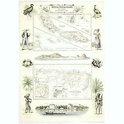
Dutch Possessions in South America and the West Indies.
Two maps are shown: one of the island of Curaçao with insets of the Leeward and the Lesser Antilles and a map of the northern part of Dutch Guyana with insets of a plan ...
Place & Date: London, 1860
Selling price: $185
Sold in 2020
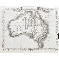
Australia.
A very detailed and up-to-date map, including tables of counties in Victoria, Western Australia, and New South Wales.This is the uncommon and slightly later edition by Ra...
Place & Date: London, ca 1860
Selling price: $39
Sold in 2020
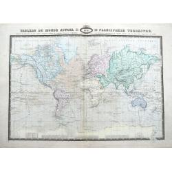
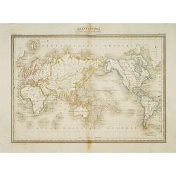
Tableau Du Monde Actuel Ou Planisphere Terrestre, indiquant les Itineraires de plus celebres Navigateurs. . .
A large and scarce map of the world shown on Mercator's projection. Filled with details and explorers routes and dates. Names even smallest islands. Shows the magnetic po...
Place & Date: Paris, 1860
Selling price: $121
Sold in 2021

Carte du Voyage Sur la Mer du Monde.
A scarce lithographed map of the Mer Du Monde, showing the track of life with many funny place names in French, such as Ile du Travail, Detroit des etudes, Ile des Desirs...
Place & Date: Paris? ca 1860
Selling price: $100
Sold in 2021
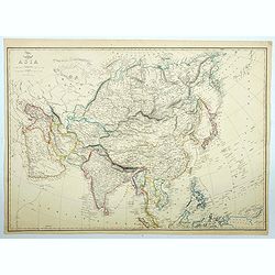
Asia.
The large map of the continent of Asia appeared in the part-work "Dispatch Atlas" issued in supplements and ultimately as a complete volume. A detailed map with...
Place & Date: London, 1860
Selling price: $16
Sold in 2021
![[Game of the goose] Jeu Moral et Instructif.](/uploads/cache/48342-250x250.jpg)
[Game of the goose] Jeu Moral et Instructif.
Goose board game. Oval with boxes numbered from 1 to 63. The boxes illustrate virtues, sins, biblical episodes or professions.The route leads to Paradise. In the central...
Place & Date: Metz,, ca 1860
Selling price: $77
Sold in 2022

Carte de la partie du Detroit de Magellan reconnue par les Corvettes L'Astrolabe et La Zelee. . .
A detailed map of the Straits of Magellan, prepared by Vincendon Dumoulin after a visit of the ships L'Astrolabe and La Zelee in the year 1841. From Voyage au Pole Sud et...
Place & Date: Paris, 1860
Selling price: $200
Sold in 2023

Carte du voyage sur la mer du monde
Curious humorous map in French, showing curious islands in the "Sea of the World" such as: Island of work, Island of desires, Island of greed, Island of injusti...
Place & Date: Lille, ca. 1860
Selling price: $110
Sold in 2023
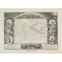
Planisphère.
One of the last decorative maps of the area. In side panels representations of the four seasons. In original o.l. color, from his "Atlas Universel Illustré". T...
Place & Date: Paris, 1845-1860

Chicago in 1820.
A fascinating steel engraving of early frontier Chicago, adapted from a sketch done by H. R. Schoolcroft. The view depicts indigenous Americans canooing on Lake Michigan ...
Place & Date: Washington DC, ca 1860
Selling price: $90
Sold
Mexique Antilles, États-Unis..
Very detailed map of the United states. Engraved by Ch.Dyonnet, prepared by A.H.Dufour for his "Atlas Universele".
Place & Date: Paris 1860
Selling price: $200
Sold
Mappe-Monde suivant la projection de Mercator.
A fine map of the world in a Mercator projection and with Australia in the center of the map.Engraved by Thierry, rue des Mathurins St.Jacques No.1, Paris.
Place & Date: Paris, 1860
Selling price: $100
Sold in 2014
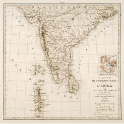
Carte des établissements .. L'Inde..
Detailed map of India. On verso 5 manuscript maps in pen and ink showing "Territoire de Pondichèry", "Territoire de Karikat, scale 1:300.000", "...
Place & Date: Paris 1860
Selling price: $80
Sold
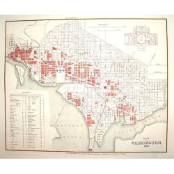
Plan von Washington 1845
A finely engraved plan of pre Civil War Washington D.C., as it was in 1845. There is an inset plan of the Capitol building, which was not yet built at the time. In additi...
Place & Date: Heidelberg, 1860
Selling price: $320
Sold
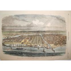
The City of Chicago, Illinois, Where the Republican Convention will Meet on May 16, 1860.
A handsome woodcut pre-great-fire view of Chicago. The work depicts the city as seen in the late 1850s and centers on the Chicago River.Numerous sailing and steam vessels...
Place & Date: New York, 1860
Selling price: $115
Sold

Vue de New York.
A view of New York over the bay with ships and boats as well as some people in the foreground. Probably after D. Fabronius and published by P. Cremetti in Brussels.
Place & Date: Bruxelles 1860
Selling price: $1300
Sold

Nouvelle Orléans.
A view of a part of the town of New Orleans, seen from the river with ships and boats in the foreground. After D. Fabronius (in the stone signed) and published by P. Crem...
Place & Date: Bruxelles 1860
Selling price: $1300
Sold
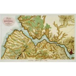
Karte des Bosporos und dier Umgebungen.
A very nice map centered on the Bosporus. Title cartouche on the upper left-hand corner.
Place & Date: Paris, ca.1860
Selling price: $300
Sold in 2013
![[ South East Asia with the North East coast of Australia ].](/uploads/cache/26130-250x250.jpg)
[ South East Asia with the North East coast of Australia ].
General map of the South East Asia with the North East coast of Australia.
Place & Date: France, c. 1860
Selling price: $95
Sold in 2013
![[Map puzzle] Atlas géographique.](/uploads/cache/16637-250x250.jpg)
[Map puzzle] Atlas géographique.
A uncommon geographic Jigsaw puzzle. With a double hemisphere world map, Europe and France. The maps used for the puzzle are geographically sophisticated and well engrave...
Place & Date: Paris 1860
Selling price: $295
Sold

The old couple.
Etching by Jozef Israels (1824-1911) of a farm interior with an old woman on a chair, light falling on her from the right handed-side window. An Ill(?) man in his bed.No ...
Place & Date: The Netherlands, ca.1860
Selling price: $35
Sold in 2011
2 historial plates dealing with US/Mexican War (1846-1848).
2 plates sold by the famous Mexican publisher Julio Michaud's shop (estampería) who collaborated with a man known today only as Thomas. He published Álbum Pintoresco de...
Place & Date: Mexico/ Paris c.1860
Selling price: $300
Sold
Messico Nuova Spagna.
Uncommon map of Mexico and Baya California. Prepared by T.Duvotenay and published in an Italian version by Calcolitografia Fratelli Doyen, Torino. All nales translated to...
Place & Date: Milan c.1860
Selling price: $100
Sold

Malte.
A nice an beautiful panoramic view of Valletta with extensive shipping. Engraved by Aubert.
Place & Date: Paris, c.1860
Selling price: $190
Sold in 2008
![[ Christophe Colomb ]](/uploads/cache/21197-250x250.jpg)
[ Christophe Colomb ]
Uncommon wood block print showing Columbus and his egg.
Place & Date: France c. 1860
Selling price: $40
Sold

Vue de New York.
This scene includes careful renderings of the buildings in lower Manhattan and Brooklyn. Castle Garden, which was then an entertainment hall, is shown offshore of Battery...
Place & Date: Paris 1860
Selling price: $450
Sold
United States of North America. Western States.
Detailed map of western part of North America by Keith Johnston, a well-known publisher of maps who continually updated their regional maps. From his Royal Atlas . With g...
Place & Date: Edinburg 1860
Selling price: $90
Sold

Carte Physique et Routiere de la Sicile..
A very nice exemplary centred on Sicily. Printed by L.Turgis active in Paris and New York. Malta is represented on the bottom.
Place & Date: Paris, 1860
Selling price: $100
Sold

Carta moderna dell' Isola di Sicilia e delle isole minori circonvicine . . .
Map of Sicily from "Atlante Geografico dell Italia". In lower left corner inset maps of Malta.
Place & Date: Rome, 1860
Selling price: $150
Sold in 2018

Amérique Boréale, Nouv.le Bretagne & Canada.
Very detailed map from Atlas Sphérodïdal & Universel de géographie , Prepared by F.A.Garnier and edited by Jules Renouard, rue de Tournon, Paris.Uncommon map with ...
Place & Date: Paris 1860
Selling price: $150
Sold
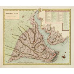
Constantinople superficie 3,975,000 Toises.
Decorative and very detailed plan of Istanbul and its environs. With a numbered key (1-86) to principal places of interest.
Place & Date: Paris 1860
Selling price: $320
Sold

Pianta della citta di Trieste.
Very finely engraved and detailed plan of Triest. Engraved by V.Angeli and included in: Atlante Geografico dell Italia . To the left, a key to the principal buildings and...
Place & Date: Rome, 1860
Selling price: $100
Sold in 2020
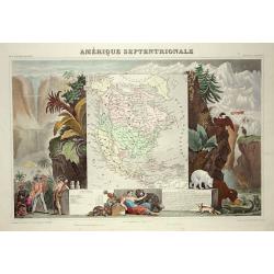
Amerique Septentrionale
Lovely map with an INDEPENDENT TEXAS. The United States extending into present day Canada, Russia in control of Alaska and Mexico's northern border according to the Treat...
Place & Date: Paris 1860
Selling price: $240
Sold

Miniature of St Barbara, on vellum from a neo-Gothic Book of Hours.
RECTO : Large miniature of St Barbara, a roman martyr, with her emblem, on the verso of a 15th century leaf from a Book of Hours, Northern Netherlands, 19th cent. Close f...
Place & Date: Flanders ca.1860
Selling price: $1800
Sold

Miniature showing St. Catherine of Alexandria. Manuscript leaf on vellum from a Neo-Gothic Book of Hours.
RECTO : Miniature showing St. Catherine of Alexandria, who defied the emperor and his wisemen in philosophy, he sentenced her to death through breaking her bones with a h...
Place & Date: Flanders ca.1860
Selling price: $1950
Sold

Miniature of St. John, the Baptist. Manuscript leaf on vellum from a Neo-Gothic Book of Hours.
RECTO : Miniature of St. John, the Baptist, with a lamb on a book, wearing a cloth of camelhair of the heremite in the desert, not so here though with a luscious backgrou...
Place & Date: Flanders ca.1860
Selling price: $1800
Sold