Browse Listings

Oceania.
Beautiful steel plate map of the Oceania region. A very decorative work featuring depictions of indigenous peoples pursuing various activities, foliage and geographic sce...
Place & Date: Paris, ca. 1855
Selling price: $140
Sold in 2010

Vista de la iglesia mayor y de la ermita del buenviaje.
Decorative view of the High Church and the Hermitage of Good Voyages at San Juan de los Remedios, by un unknown lithographer after Frederico Mialhe (1810-1881).He is know...
Place & Date: Havana, ca. 1855
Selling price: $500
Sold in 2010
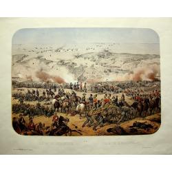
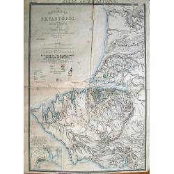
Siége de Sébastopol; Siege of Sebastopol.
Panoramic lithograph view of the city and port of Sevastopol (Crimea) being attacked by British and French troops during the war of 1854/1855.A very detailed and dramatic...
Place & Date: Paris / Lyon, c1855
Selling price: $130
Sold in 2011

Michigan and Wisconsin
Map of Michigan and Wisconsin. Page 35/36 from Sidney E. Morse's: System of Geography for the use of schools , published by Harper and brothers, 329 Pearl Street, New Yor...
Place & Date: New York 1855
Selling price: $20
Sold in 2011
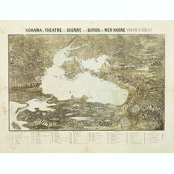
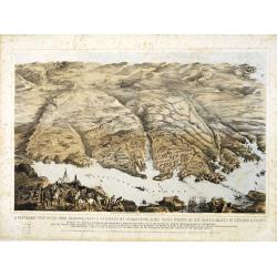
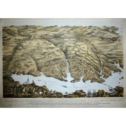
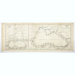
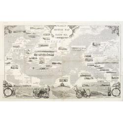
Panorama du théatre de la guerre sur les bords de la Mer Noir vu a vol d'oiseau.
Scarce plan and panoramic view of the Black Sea. With a numbered key (1-60) in lower part. Edited by Lémérey and E.Gratier. Printed with Gabiller and Molenaars.
Place & Date: Paris, c.1855
Selling price: $170
Sold in 2011
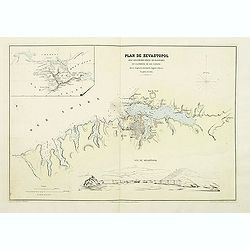
Plan de Sevastopol avec ses fortifications ses batteries et la portée de ses canons.
Map of the area around Sevastopol, engraved by Erhard and prepared by D.Ramee. Printed by Caillet. In the upper left corner is an inset plan of the Crimea. (380x555mm.). ...
Place & Date: Paris, Caillet, 1855
Selling price: $100
Sold in 2011

Seat of War in the Krimea.
Steel engraved folding map of the Krimea with original hand color. With panoramic views of Sevastopol, Balaklava and Eupatoria from Anchorage. Maps of the Black Sea and a...
Place & Date: London, 1855
Selling price: $140
Sold in 2012
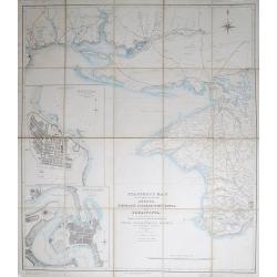
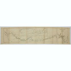
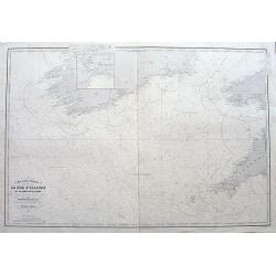
Stanford's Map of the Roads &c. Between Odessa, Nikolaief, Perekop, Simfieropol, and Sebastopol.
Folding map of south-eastern Ukraine, focusing on the region between Odessa and just east of Balaklava. Large inset maps of Odessa and Nikolayev to left edge. The whole d...
Place & Date: London, 1855
Selling price: $220
Sold in 2012

A set of 10 humorous prints from the Russian Empire's war with French and British Empire's.
Ten humoorous prints with the following titles: - Another Russian Victory!!! July 8th 1854. - The Russian Frankenstein and His Monster July 15th 1854. - The Real ...
Place & Date: London 1854-1855
Selling price: $130
Sold in 2012
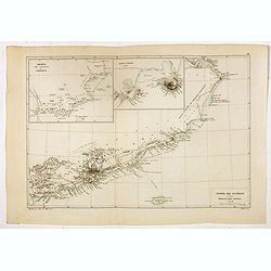
The Environs of Sevastopol with the Batteries & Approaches.
Large lithographed plan of the Siege of Sevastopol. Shows the surroundings of the city in great topographical detail, and all the troop locations. Also indicates roads, t...
Place & Date: London, c1855
Selling price: $120
Sold in 2012

A set of 9 humorous prints from the Russian Empire's war with French and British Empire's.
Nine humorous prints with the following titles: - The Queen visiting the Imbeciles of the Crimea,1855- Cruel Treatment of Russian Prisoners in England,1854.- Bursting of ...
Place & Date: London, 1854-1855
Selling price: $100
Sold in 2012

A set of 10 humorous prints from the Russian Empire's war with French and British Empire's.
Ten humorous prints with the following titles: 1.Tightening the Grip2.A Water Party3.Sir Edmund Lyons going in his Brougham to the Opera at Sebastopol4.Cruel Treatment of...
Place & Date: London, 1854-1855
Selling price: $90
Sold in 2012
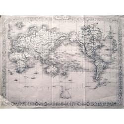
The World on Mercator's Projection.
Detailed map of the world. With suggested Antarctica! This is the uncommon and slightly later edition by Rapkin based on Tallis' maps. The vignettes have been removed....
Place & Date: London, c.1855
Selling price: $46
Sold in 2013
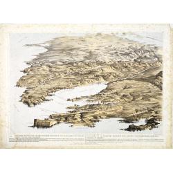
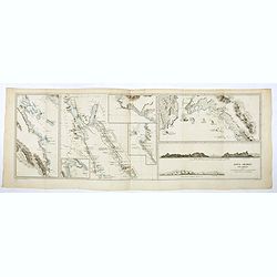
A panoramic view of the town, harbour, forts & defences of Sebastopol & the siege works of the allied armies of England & France. . .
A panoramic town-plan of the town, harbour, forts and defenses of Sevastopol in Ukraine.Chromolithographed and designed by Thomas Packer, and published by Stannard and Di...
Place & Date: London, 1855
Selling price: $275
Sold in 2013
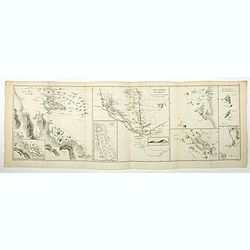
![A Panoramic View of the Position now occupied by the Allied Armies before Sebastopol [. . .] sketched by command of the Emperor Louis Napoleon by an eminent officer of the French Imperial Engineers](/uploads/cache/33753-250x250.jpg)
A Panoramic View of the Position now occupied by the Allied Armies before Sebastopol [. . .] sketched by command of the Emperor Louis Napoleon by an eminent officer of the French Imperial Engineers
A panoramic view of the position occupied by the Allied Armies before Sevastopol in Ukraine.Chromolithographed and designed by Thomas Parker, and published by Read & ...
Place & Date: London, 1855
Selling price: $250
Sold in 2013
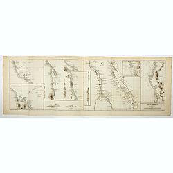
Panoramic view of the Present Extended Position of the Allied Armies of England, France, Turkey and Sardinia. - Panorama de la position presente des armées alliées, Anglaise, Française, Turque et Sarde. . .
Panoramic view of the position of the Allied Armies of England, France, Turkey and Sardinia at the south side of Sevastopol in Ukraine.Chromolithographed and designed by ...
Place & Date: London, 1855
Selling price: $250
Sold in 2013

Cavaliere Yuto e Capo Arrapohe & Capo Sioux Yanctons e Capo Ponkas. (2 prints)
Two chromolithograph prints of Native Americans including those from the Arrapoho and Ponka tribes. They are from an unidentified source by an anonymus artist. The publis...
Place & Date: Rome, c.1855
Selling price: $27
Sold in 2016
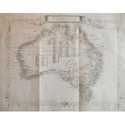
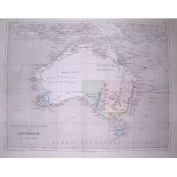
Australia.
Very detailed and up-to-date map, including tables of counties in Victoria, West Australia, and NSW. This is the uncommon and slightly later edition by Rapkin based on T...
Place & Date: London, c1855
Selling price: $65
Sold in 2013
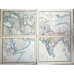
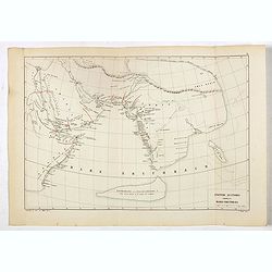
Map of the Countries lying between Turkey & Birmah, comprising Asia Minor, Persia, India, Egypt & Arabia, and including the Black, Caspian & Red seas by James Wyld, Geographer to the Queen, Charing Cross East. Model of the Earth, Leicester Square, London.
Map of the Countries lying between Turkey & Birmah, comprising Asia Minor, Persia, India, Egypt & Arabia, and including the Black, Caspian & Red seas by James...
Place & Date: London, 1855
Selling price: $375
Sold in 2013
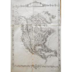
North America.
Very detailed and up-to-date map of North America, from Russian America (Alaska) to Panama, including the West Indies. With numerous place names and Indian tribes! This ...
Place & Date: London, ca. 1855
Selling price: $80
Sold in 2013

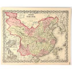
China and Birmah.
Very detailed and up-to-date map, from the Bay of Bengal to Formosa (Taiwan). Includes also a part of Luzon. Filled with place names! This is the uncommon and slightly l...
Place & Date: London, ca. 1855
Selling price: $26
Sold in 2013
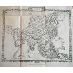
Asia.
Very detailed and up-to-date map, reaching from the Ural mountains until New Guinea. Locating tribes, mountains, rivers, cities,... This is the uncommon and slightly lat...
Place & Date: London, c1855
Selling price: $27
Sold in 2013

Asia Minor.
Very detailed and up-to-date map of Turkey including Cyprus. With numerous place names, roads connecting the towns, rivers, mountains, and regions. This is the uncommon ...
Place & Date: London, c1855
Selling price: $15
Sold in 2013
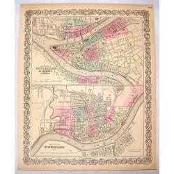
The Cities of Pittsburgh & Allegheny & The City of Cincinnati.
A hand-colored first edition of Colton's interesting two part map of Pittsburgh Pennsylvania and Cincinnati, Ohio. Interestingly, both maps are drawn to the same scale.
Place & Date: New York, 1855
Selling price: $15
Sold in 2016
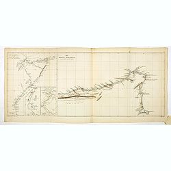
A Panoramic View of the Town, Harbour, Forts & Defences of Sebastopol & The Siege Works of The Allied Armies of England & France.
Printed & Published April 18th 1855 by Stannard & Dixon 7, Poland St London. A large panoramic plan of the town, harbour, forts and defenses of Sevastopol in Ukra...
Place & Date: London, 1855
Selling price: $250
Sold in 2014
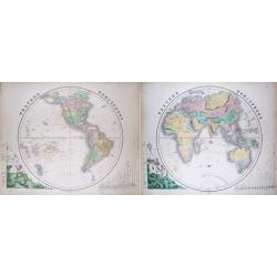
(Pair of 2 maps): Western Hemisphere & Eastern Hemisphere
Impressive size maps of the hemispheres, with comparisons of mountain hights and river lengths. Filled with place names and many interesting geographical features: -larg...
Place & Date: Edinburgh, c1855
Selling price: $36
Sold in 2014
Nouvelle Hollande ou Australie.
Very interesting and detailed map of Australia, with the border of "Australie heureuse" along the Lachlan River. With numerous bays, rivers, hills, islands, etc...
Place & Date: Paris, c1855
Selling price: $21
Sold in 2014
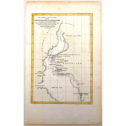
Chart Exhibiting the Discoveries of the Second American Grinnell Exhibition in Search of Sir John Franklin.
The expedition searching for Sir Franklin resulted in important advances in the exploration of Greenland and other previously unexplored Arctic regions.
Place & Date: New York, 1855
Selling price: $99
Sold in 2016
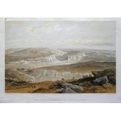
The ruins of Inkermann and city of caverns.
A spectacular view of the area of Inkerman in the Ukraine, now under Russian control (Crimean peninsula). Original colored lithograph by Day & Son. Published May 22nd...
Place & Date: London, 1855
Selling price: $40
Sold in 2015
Chart of the Coast of China and of the Japan Islands including the Marianes and a Part of the Philippines.
Commodore Perry’s Sailing Directions for China and Japan with large map of Asian waters including the Mariana Islands and a part of the Philippines. Compiled by order o...
Place & Date: Washington, 1855
Selling price: $120
Sold in 2015
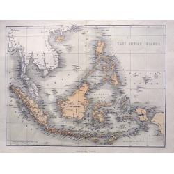
East Indian Islands.
Superb map of Indonesia, filled with many place names. Shows the area from Birma and Thailand to Papua New Guinea, including the Philippines, Singapore, Malaysia, Borneo,...
Place & Date: London, ca. 1855
Selling price: $58
Sold in 2015

Der Vulkan-Gürtel und die Central-Gruppen des grossen Oceans.
Map shows the volcano's around the Pacific Ocean, China, Indonesia, Hawaii, and the Americas. Active volcano's are underlined in orange. Two circled areas show the main g...
Place & Date: Hildburghausen, ca. 1855
Selling price: $1
Sold in 2015

Northern Italy & Southern Italy (Two Maps)
A matched pair of maps that cover all of Italy. These beautifully engraved, hand-colored maps were published in Colton's monumental world atlas “Illustrated Atlas of th...
Place & Date: New York, 1855
Selling price: $35
Sold in 2017
Colton's China
A map of China, Korea, Taiwan, Hong Kong and Macao. Surrounded by Colton's typical spiral motif border. From Colton's "ALAS OF THE WORLD".Joseph Hutchins Colton...
Place & Date: New York, 1855
Selling price: $42
Sold in 2016
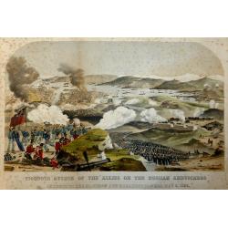
Vigorous Attack of the Allies on the Russian Ambuscades In front of the Mamelon and Malakoff Towers, May 9, 1855.
A highly detailed lithograph showing the battle to silence the Malakoff Towers. In the distance a view of Sebastopol looking towards the Dockyard Harbour... The Malakoff ...
Place & Date: London, 1855
Selling price: $40
Sold in 2017
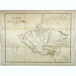
Plano della battaglia della Cernaia.
Large lithographed map showing the Battle of the Chernaya. Decorative title with numbered key (1-17) and a color key indicating the French, English, Italian, Turkish and ...
Place & Date: Milan, 1855
Selling price: $200
Sold in 2017

Carte Generale dell Europa Divisa ne Suoi Principali Stati.
A pleasing map of Europe by Cassella, published in Turin in 1855.
Place & Date: Turin, 1855
Selling price: $26
Sold in 2017
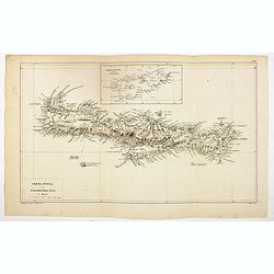
Creta Insula sec. Stadiasmum Maris Magni.
Delicate map of ancient Crete, according to the "Stadiasmus Maris Magni", prepared by Karl Wilhelm Ludwig Muller (1813-1894) and published in "Geographi Gr...
Place & Date: Paris, Ambrosio Firmin Didot, 1855
Selling price: $30
Sold in 2017

Cyprus Insula ad Stadiasmum Maris Magni S. 297-317
Delicate map of ancient Crete according to the "Stadiasmus Maris Magni", prepared by Karl Wilhelm Ludwig Muller (1813-1894) and published in "Geographi Gra...
Place & Date: Paris, Ambrosio Firmin Didot, 1855
Selling price: $25
Sold in 2017

Scylacis Periplus. . .
Delicate map of ancient Greece and the West coast of Turkey according to the "Stadiasmus Maris Magni", prepared by Karl Wilhelm Ludwig Muller (1813-1894) and pu...
Place & Date: Paris, Ambrosio Firmin Didot, 1855
Selling price: $10
Sold in 2017
Sinus Arabici pars borealis secundum Agatharchidem, Artimidorum, Plinium, Ptolemaeum. (Northern part of the Red Red Sea)
Seven maps on one sheet showing the Northern part of the Red Sea according to the "Stadiasmus Maris Magni", prepared by Karl Wilhelm Ludwig Muller (1813-1894) a...
Place & Date: Paris, Ambrosio Firmin Didot, 1855
Selling price: $20
Sold in 2020
Sinus Arabici pars meridionalis secundum Agatharchidem, Artimidorum, Plinium, Ptolemaeum. (Southern part of the Red Red Sea)
Eight maps on one sheet showing the Southern part of the Red Sea according to the "Stadiasmus Maris Magni", prepared by Karl Wilhelm Ludwig Muller (1813-1894) a...
Place & Date: Paris, Ambrosio Firmin Didot, 1855
Selling price: $35
Sold in 2020
Sinus Arabici pars media secundum Agatharchidem, Artimidorum, Plinium, Ptolemaeum. (Center part of the Red Red Sea)
Nine maps on one sheet showing the center part of the Red Sea according to the "Stadiasmus Maris Magni", and prepared by Karl Wilhelm Ludwig Muller (1813-1894) ...
Place & Date: Paris, Ambrosio Firmin Didot, 1855
Selling price: $35
Sold in 2020
Ora regionis aromatiferae a ras gulvainy adbasHafoun. / Libye oraorientalissecundum Periplum maris Erythraei. (The United Arab Emirates)
Four maps on one sheet. The right hand map showing The United Arab Emirates, the other maps the larger region including Oman. These ancient maps are according to the &quo...
Place & Date: Paris, Ambrosio Firmin Didot, 1855
Selling price: $60
Sold in 2020
Arabiae Ora australis secundum Periplum maris Erythraei. (Oman)
Three maps on one sheet. The larger map showing Oman, the other maps the larger region including Oman. These ancient maps are according to the "Stadiasmus Maris Magn...
Place & Date: Paris, Ambrosio Firmin Didot, 1855
Selling price: $50
Sold in 2020

Dachinabadae ora Maritima secundum anonymi periplum maris erythrei. (India)
Two ancient maps on one sheet showing India, prepared by Karl Wilhelm Ludwig Muller (1813-1894) and published in "Geographi Graeci Minores". Muller wrote in Lat...
Place & Date: Paris, Ambrosio Firmin Didot, 1855
Selling price: $20
Sold in 2017
Nearchi Navigatio ab indo ad Euphratem secundum arriani historiam Indicum. . .
Three maps showing the coastline of Iran and Pakistan according to the "Stadiasmus Maris Magni", and prepared by Karl Wilhelm Ludwig Muller (1813-1894) and publ...
Place & Date: Paris, Ambrosio Firmin Didot, 1855
Selling price: $25
Sold in 2019
Ponti Euxini Periplus secundum Arrianum.
Two ancient maps on one sheet showing the Black Sea and Ukraine, prepared by Karl Wilhelm Ludwig Muller (1813-1894) and published in "Geographi Graeci Minores"....
Place & Date: Paris, Ambrosio Firmin Didot, 1855
Selling price: $20
Sold in 2017
Anonymi auctoris periplus Maris Erythraei.
Delicate map showing the Indian Ocean during ancient times according to the "Stadiasmus Maris Magni", and prepared by Karl Wilhelm Ludwig Muller (1813-1894) and...
Place & Date: Paris, Ambrosio Firmin Didot, 1855
Selling price: $25
Sold in 2017

Russia in Europe showing the Territorial Acquisitions since the time of Peter the Great.
"Russia in Europe showing the Territorial Acquisitions since the time of Peter the Great" This map shows the acquisitions from Turkey, Sweden, Poland and Persia...
Place & Date: London, 1855
Selling price: $80
Sold in 2019

Atlas de physique et de meteorologie agricoles.
Rare atlas of meteorology and agronomy of France, Europe and the world printed by Hayet in Versailles. Illustrated with frontispiece and 13 maps lithographed in colors. T...
Place & Date: Paris, Bachelier / Versailles, Hayet, 1855
Selling price: $1550
Sold in 2019
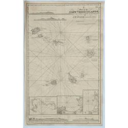
A Chart of the Cape Verde Islands, Drawn from the Latest Authorities by J.W. Norie, Hydrogrpher.
An original and striking, mariners chart of the Cape Verde Islands in the Atlantic Ocean, off the coast of Africa. It is by J. W. Norie one of the most important chart ma...
Place & Date: London, 1855
Selling price: $150
Sold in 2018

Venice.
A lovely steel engraved plan, on 2 sheets, of Venice by the Society for the Diffusion of Useful Knowledge (SDUK). This English philanthropic enterprise was entirely devot...
Place & Date: London, 1855
Selling price: $110
Sold in 2018
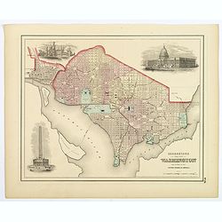
Georgetown and the City of Washington, the Capital of the United States of America.
An excellent 1855 example of Colton's plan of Washington D.C. and Georgetown. It covers the city in detail from Georgetown (Georgetown University, then College, shown) in...
Place & Date: New York, 1855
Selling price: $50
Sold in 2018
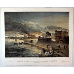
Burning of the Government buildings at Kertch.
A fine hand colored lithograph from "THE SEAT OF WAR IN THE EAST". By the illustrator William Simpson (1823-1899). Published in London in 1855 by Paul and Domin...
Place & Date: London, 1855
Selling price: $15
Sold in 2018

New York Bay & Harbor. . .
The chart provides a fantastically detailed look at the Harbor of New York and environs. The chart includes detailed depth soundings, and has a directional rose.The chart...
Place & Date: London, ca 1855
Selling price: $55
Sold in 2018
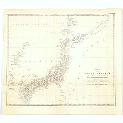
Map of the Japan Islands. . .complied by order of Commodore M.C. Perry, USN.
A map of Japan by Maury and Bent under the orders of Commodore Perry, 1855. Very good detail of the many islands with cities marked and with decent topographical informat...
Place & Date: New York, 1855
Selling price: $86
Sold in 2020
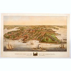
Bird's Eye View of the City of Annapolis, the Capitol of Maryland.
A wonderful large colored lithograph, by E. Sachse & Co., one of two important lithography companies operating in Baltimore during the mid nineteenth century, showing...
Place & Date: Baltimore, ca 1855
Selling price: $6600
Sold in 2020

Nicholas I. Emperor of Russia.
Steel engraved portrait of Nicholas I (1796–1855), tsar and emperor of Russia from 1825 to 1855. Engraved by G.Cook and published by Regan Paul Trench.
Place & Date: London, ca.1855
Selling price: $10
Sold in 2020
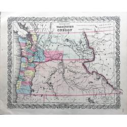
The Territories of Washington and Oregon.
Rare and early map of this region, in nice conditions.
Place & Date: New York, 1855
Selling price: $200
Sold in 2022
Percement de l'isthme de Suez. Atlas des cartes, plans, sondages, profils et forages à l'appuie du projet de la commission internationale. . .
Atlas from the third series only illustrated with 12 plates, maps, plans, sections and elevations, most folding.Surveys carried out in 1855 and 1856 in the Suez Isthmus f...
Place & Date: Paris, aux bureaux de L'Isthme de Suez, Henri Plon, 1856
Selling price: $500
Sold in 2020
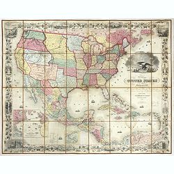
United States of America the British Provinces, Mexico...
Large engraved folding map surrounded by a decorative grapevine border interspersed with twelve insets and a large American eagle in front of a port. The map's coverage ...
Place & Date: New York, 1856
Selling price: $3600
Sold in 2019

Impero di Marocco.
An interesting and uncommon detailed and large-scale Italian map of Morocco. The Italian text below provides historical, political and commercial information. Published i...
Place & Date: Naples, 1856
Selling price: $50
Sold in 2021
Carte des entrées de la Mer D'Irlande et du Canal de Bristol. . .
A large sea-chart of southern Ireland and parts of Cornwall and Wales. With numerous old pencil notes. colored yellow dots indicate the fire signals along the coasts. Wit...
Place & Date: Paris, 1856
Selling price: $30
Sold in 2020

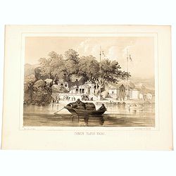
Whampoa Pagoda & Anchorage.
A lithographic illustration from the Narrative of The Expedition of an American Squadron to the China Seas and Japan, Performed in the Years 1852, 1853 and 1854, under th...
Place & Date: New York, 1856
Selling price: $15
Sold in 2020
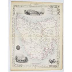
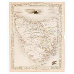
Van Diemen's Island or Tasmania.
Double page steel engraved map of Tasmania. Three vignette including one of Hobart Town. Decorative scrolling and title cartouche to the edges of the image. For the Great...
Place & Date: London & New York: John Tallis & Company, 1856
Selling price: $100
Sold in 2020
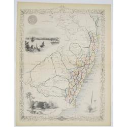
New South Wales.
Double page steel engraved map. With vignette illustrations of Sydney Cove and The Murray. Two other illustrations of the Seal of New South Wales and the plant XanthorrÃ...
Place & Date: London & New York: John Tallis & Company, 1856
Selling price: $100
Sold in 2020
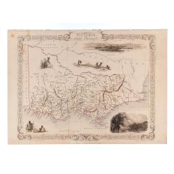
Victoria or Port Phillip.
24.5 x 32.5 cm. Original outline color. Steel engraved map. Five vignette illustrations including Melbourne. Decorative scrolling and title cartouche to the edges of the ...
Place & Date: London & New York: John Tallis & Company, 1856
Selling price: $120
Sold in 2023

Jesuit Convent in Macao.
In the August of 1853, Commodore Perry departed Lew Chew for China. His first stop was in Macao, where he took a house for an extended stay. This lithograph is a view of ...
Place & Date: New York, 1856
Selling price: $27
Sold in 2020
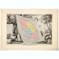
Colonies Francaises - Martinique Amerique du Sud.
A beautiful map from one of the finest decorative atlases of the nineteenth century. The map is surrounded with engravings depicting the countryside with trade goods incl...
Place & Date: Paris, 1856
Selling price: $17
Sold in 2020

China Girl. Sycee head Dress.
A lithograph taken from a daguerreotype from Commodore M.C. Perry's' Narrative of the Expedition of an American Squadron to the China Seas and Japan, Performed in the Yea...
Place & Date: Philadelphia, ca 1856
Selling price: $25
Sold in 2020
Chinese Temple, Macao.
A pleasant view of the important Chinese Temple in Macao.
Place & Date: Philadelphia, 1856
Selling price: $15
Sold in 2020
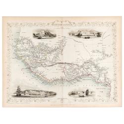
Western Africa.
Original steel engraved map of Western Africa. Map accompanied by vignette scenes of Christiansborg, Cape Coast Castle, Sierra Leone and Bakel. Decorative scrolling and t...
Place & Date: London & New York: John Tallis & Company, 1856
Selling price: $70
Sold in 2023
The Bucareli Promenade - Paseo de Bucareli - Promenade de Bucareli.
Lithographed plate of the Bucareli Promenade of Mexico City. The plate has caption title in English, Spanish and French, from the rare publication MEXICO Y SUS ALREDEDORE...
Place & Date: Mexico, Establecimiento Litografico de Decaen, 1855-1856
Selling price: $100
Sold in 2021
Van Diemen's Island or Tasmania.
Original steel engraved map of Tasmania. Three vignettes including one of Hobart Town. Decorative scrolling and title cartouche to the edges of the image. (Map 22 x 29.5 ...
Place & Date: London / New York: J. / F. Tallis, 1856
Selling price: $80
Sold in 2023
Picture map of the Baltic sea.
Large wood block engraved map of the Baltic Sea and adjacent countries (Denmark, Sweden, Finland, Estonia, Latvia, Lithuania, Poland, Germany) with numerous vignettes to ...
Place & Date: London, 1856
Selling price: $210
Sold in 2014
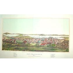
San Francisco
From Henry Bill's History of the World, a justly famous and sought after bird's-eye view of San Francisco published within seven years of the Gold Rush. It contains a leg...
Place & Date: New York, 1856
Selling price: $490
Sold

Atlas Geográfico Universal.
Folio, hlf. leath., damaged.. With 42 double-page maps. Some staining, mainly in marges.A Spanish atlas with 42 maps ( a.o. 2 world maps, 7 maps of (parts of) the America...
Place & Date: Barcelona, 1856
Selling price: $1500
Sold

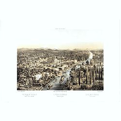
La Habana: vista general tomada desde la entrada del puerto.
A splendid, large lithographed view of the city of Havana as seen from the north, beautifully and subtly colored. The viewer is situated above the sea, looking into the m...
Place & Date: Havana, Sergio Martin, 1856
Selling price: $3000
Sold

Cardenas Vista general tomada desde la Bahia.
A splendid, large lithographed view of the city of Cardenas, beautifully and subtly colored. The viewer is situated above the sea, looking to the harbour. Dozens of boats...
Place & Date: Havana, Sergio Martin, 1856
Selling price: $2000
Sold