Browse Listings
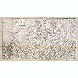
Carte des voies de cummunication de la Russie d'Erope et des etats voisins dressée par ordre se s.m. L'Empereur. . .
Detailed folding map of Northern part of Russia, prepared by L. Sagansan. The map is engraved on stone by the brothers Avril and printed by Kaeppelin in Paris.
Place & Date: Paris, 1854
Selling price: $250
Sold in 2015
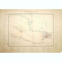
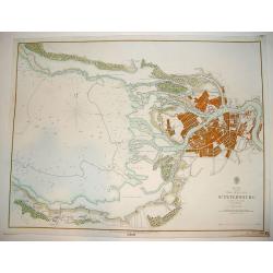
St.Petersbourg et Kronstadt.
Detailed map of the region with Kronstadt and St. Petersburg. Published by J. Correard, Directeur du journal des Sciences Militaires, R. Christine Dauphine a Paris . In l...
Place & Date: Paris, 1854
Selling price: $200
Sold in 2013
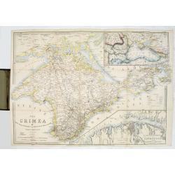
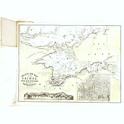
The Crimea by James Wyld Geographer to the Queen & H.R.H. Prince Albert.
The second edition of this folding map of Crimea. In the upper right corner, an inset map of the areas around the Black Sea, "The Town & Harbor of Sevastopol wit...
Place & Date: London, 1854
Selling price: $250
Sold in 2017

India.
Large detailed map of India by Sidney Hall published by A. &. C. Black in Edinburgh Steel engraving with original color Relief shown by hachures. States shown by tint...
Place & Date: Edinburgh, 1854
Selling price: $50
Sold in 2014
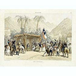
Historia de Chile. No. 20. Una chingana.
From "Historia de Chile." by Claudio Gay, a French naturalist, who was working under contract to the Chilean government between 1830-1833. Upon his return to Fr...
Place & Date: Paris, 1854
Selling price: $35
Sold in 2014
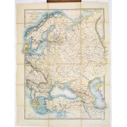
The Russian & Ottoman Empires, Sweden, Denmark, Prussia & Austria.
Detailed map of Russia, Scandinavia, Turkey, Crimea and Black Sea and Caspian Sea. Including railway from Moscow to St. Petersburg.James Wyld (the younger) was geographer...
Place & Date: London, 1854
Selling price: $170
Sold in 2017

Cronstadt in the Baltic with the fortifications, batteries's & range of the guns &c.
A rare map showing the area around Cronstadt, which was an island defense for St Petersburg. The map includes the range of guns in addition to the position of the fortifi...
Place & Date: London, 1854
Selling price: $500
Sold in 2015
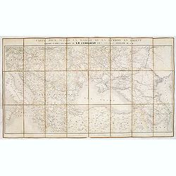
Carte pour suivre la marche de la guerre en Orient, dressée d'après les ordres de l'empereur: par L. Sagansan.
Detailed folding map of the theatre of war in the Balkans, Ukraine and around the Black Sea, indicating the Austrian, Russian and Turkish spheres of influence, prepared b...
Place & Date: Paris, ca. 1854
Selling price: $50
Sold in 2019
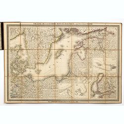
Theatre de la guerre dans la Baltique, par Mr. le Colonel LAPIE.
Excellent detailed folding map of the Baltic Sea. With inset map of Finland in lower right (195x185mm.) and inset plans of "Environs de Riga", "Plan de la ...
Place & Date: Paris, 1854
Selling price: $250
Sold in 2014
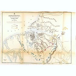
SEVASTOPOL showing the positions of the allied camps and the batteries. . . 5th edition.
Fifth edition of this fine and important single sheet lithographed plan in a scale of ca. 1:21 500 of Sevastopol. With some soundings and seabed contours. Scales in yards...
Place & Date: London, 1854
Selling price: $500
Sold in 2014
Philips' new map of the Crimea with map of Europe and view of Sevastopol.
A well-preserved copy of this charming folding map of Russia. In lower part an inset with a panoramic view of Sevastopol. To the lower right a map of Europe.
Place & Date: London, 1854
Selling price: $250
Sold in 2014
Philips' new map of the Crimea with map of Europe and view of Sevastopol.
A well-preserved copy of this charming folding map of Russia, Poland and the Baltic States. With charming original hardcover red wrapper richly decorated with flower desi...
Place & Date: London, 1854
Selling price: $100
Sold in 2014
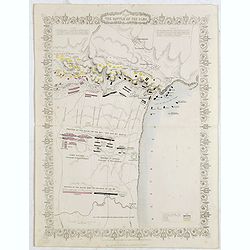
Plan of the battle of Alma.
An antique plan drawn and engraved by John Rapkin "from English and French Official Documents" Published 1858 by the London Printing and Publishing Co., London....
Place & Date: London, 1854
Selling price: $100
Sold in 2020
Siege of Sebastopol.
A detailed map of the Siege of Sebastopol. After the Battle of the Alma, the Allies proceeded to Sebastopol and commenced the Siege on September 26th, 1854. A steel engra...
Place & Date: London, 1854
Selling price: $140
Sold in 2020
The Gulf of Finland and Baltic Sea with the fortified places from Stockholm to St.Petersburg. . . / Gulf of Bothia. / Cronstadt and St. Petersburg. . . / The harbour & entrances of Sweaborg and Helsingfors. . . Cronstadt. . .
Folding map of Gulf of Finland with several inset maps. James Wyld (the younger) was geographer to the Queen and H.R.H. Prince Albert. Joined his father's business in 183...
Place & Date: London, 1854
Selling price: $200
Sold in 2015
Siege of Sebastopol.
Detailed steel engraving map of the Siege of Sebastopol. After the Battle of the Alma, the Allies proceeded to Sebastopol and commenced the Siege on September 26th, 1854....
Place & Date: London, 1854
Selling price: $31
Sold in 2019
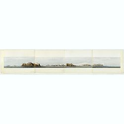
Panoramic view of the southern coast of the Crimea.
Panorama on 4 joint sheets. Impressive panorama showing the South-East coastline of Crimea from Kara-Dag and Koktebel to Feodosia, after a drawing by Captain W. H. Parker...
Place & Date: London Dickinson, 1854
Selling price: $300
Sold in 2016

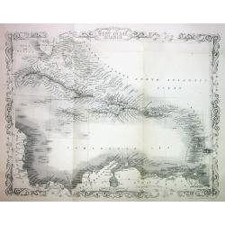
West India Islands
A superb map of the West Indies and the tip of Florida - Venezuela, drawn and engraved by William Hughes – Sidney Hall steel engraved. Published by Adam & Charles B...
Place & Date: Edinburgh, 1854
Selling price: $50
Sold in 2016
China
A highly detailed and attractive map of China drawn and engraved by William Hughes – Sidney Hall, steel engraved.Published by Adam & Charles Black in the ‘General...
Place & Date: Edinburgh, 1854
Selling price: $85
Sold in 2016
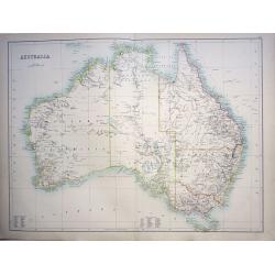
Australia
A highly detailed and attractive map of Australia drawn and engraved by William Hughes – Sidney Hall, steel engraved.Published by Adam & Charles Black in the ‘Gen...
Place & Date: Edinburgh, 1854
Selling price: $65
Sold in 2016
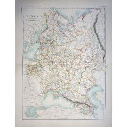
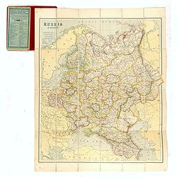
Russia in Europe
A highly detailed and attractive map of European Russia engraved by William Hughes – Sidney Hall, steel engraved.Published by Adam & Charles Black in the ‘General...
Place & Date: Edinburgh, 1854
Selling price: $65
Sold in 2019
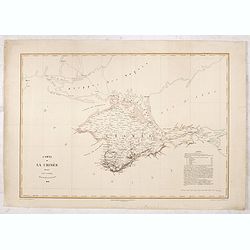
Carte de la Crimée dressée par D. RAMÉE, auteur du Plan de Sévastopol - 1854.
Uncommon map of Crimea, printed by Trinocq in Paris. Extensive legends in lower right corner.
Place & Date: Paris, Garnier Frères Libraires, 1854
Selling price: $80
Sold in 2016

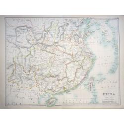
China.
A lovely, large map of China, with insets the Island of Chusan, and the Estuary of the Canto River from Hong Kong to Canton. Korean peninsula shown. Good detail and excel...
Place & Date: Edinburgh, 1854
Selling price: $95
Sold in 2018
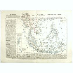
Malesia ossia Arcipelago Indiano, ed India-Transgangetica.
Attractive map of the Southeast Asia with inset map: Arcipelago di Andaman, Arcipelago di Nicobar. A wealth of information listing his cartographic sources and giving pol...
Place & Date: Naples, 1848-1854
Selling price: $250
Sold in 2017
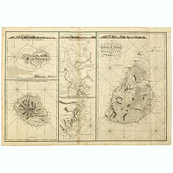
A New chart of Island of France or MAURITIUS by J.N. Norie, 1832. The island of Bourbon, called also Mascarenthas.
Five charts on one sheet, including " A New chart of Island of France or MAURITIUS", "The island of Bourbon, called also Mascarenthas", "Plan of ...
Place & Date: London, 1854
Selling price: $1000
Sold in 2018
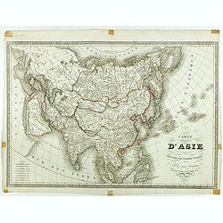
Carte d'Asie dressée par Pierre Tardieu . . .
Large map of Asia published by Édouard-Auguste-Patrice Hocquart (1789-1870?)He succeeded the print dealer Basset at rue Saint-Jacques before 1836. Engraver, he invents i...
Place & Date: Paris, Hocquart, 1854
Selling price: $270
Sold in 2024
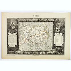
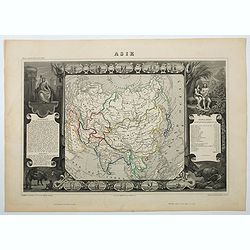
Asie.
A decorative 19th-century map of the continent. The map is surrounded by numerous steel engraved vignettes, all depicting costumes of the various peoples of Asia, Adam an...
Place & Date: Paris, 1854
Selling price: $60
Sold in 2021

Atlas elementaire simplifie de geographie ancienne et moderne.
French school atlas, with title page, complete with 30 double page maps: Maps 1-10 Cosmographie, Geographie Generale. Maps 11-20 Geographie Particulaire de l'Europe. Maps...
Place & Date: Paris, ca 1854
Selling price: $120
Sold in 2020

New Zealand.
Map of New Zealand, published by "The London Printing and Publishing Company". Drawn and engraved by John Rapkin.
Place & Date: London, 1854
Selling price: $100
Sold in 2022
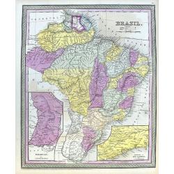
Brazil.
A fine map of Brazil, from Guiana and Venezuela in the north to Uruguay and Buenos Aires in the south. Filled with places names and also some reference to Indians. Two in...
Place & Date: Philadelphia, 1854
Selling price: $18
Sold in 2020
Asie
A decorative 19th century map of the continent. The map is surrounded by steel engraved vignettes depicting costumes of the various peoples of Asia, Adam and Eve, and sev...
Place & Date: Paris, 1854
Selling price: $60
Sold in 2020

West Coast of South America including Chile & part of Bolivia & Peru.
A decorative regional map of South America, which contains 4 maps. The top map shows Peru and the neighboring Bolivian Table Lands, while and the 3 maps at the bottom dep...
Place & Date: Edinburgh, 1854
Selling price: $65
Sold in 2020

Map of the Punjab: western Himalaya and adjoining parts of Tibet from recent Surveys, and based upon the Trigonometrical survey of India, . . .
Rare separately published map of the Western Himalayas, Tibet and part of Punjab, published as part of the Great Trigonometrical Survey of India. The map was issued by th...
Place & Date: London, W.H. Allen & Co., 1854
Selling price: $650
Sold in 2021
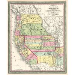
Map of the States of California, Washington, Utah, New Mexico, & Oregon Territories
This map by one of the leading U.S. cartographic firms of the period, is an excellent example of American mapping at an important time in the development of the western U...
Place & Date: Philadelphia, 1854
Selling price: $400
Sold in 2023
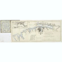
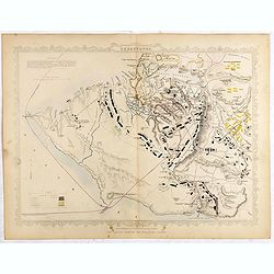
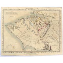
The town & harbour of Sevastopol with the batteries & approaches. . .
Rare colored linen backed map showing the harbour and town of Sevastopol, with soundings. In upper left corner a inset map (65x150mm) of the Black Sea. In bottom part a l...
Place & Date: London, March 27th, 1854

Agricultural Map of the State of New York.
A thematic map of New York State.
Place & Date: New York, c. 1854
Selling price: $32
Sold in 2013
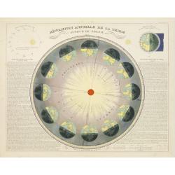
Revolution Annuelle De La Terre.
Colorful astronomical chart showing the annual succession of seasons, from winter to spring. Notes the positions of the earth during the Solstices and Equinoxes. Closer t...
Place & Date: Paris, 1854
Selling price: $180
Sold in 2009
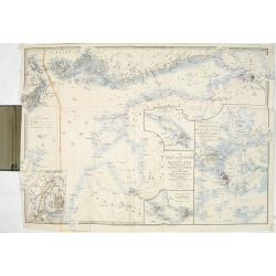
The Bay of St. Petersburg
A very rare British Admiralty nautical chart of the Bay of St. Petersburg, engraved by J & C Walker. Licensed to J. D. Potter as agent for the British Admiralty Char...
Place & Date: Dated 1854
Selling price: $1100
Sold
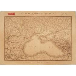
Théatre de la Guerre en Orient 1854.
Detailed map depicting the progress of the war in the Ukraine, the Crimea and the Black Sea. Including Istanbul lower left. Centered on the Black Sea area, with the north...
Place & Date: Paris, 1854
Selling price: $100
Sold in 2009
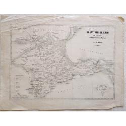
Kaart van de Krim of Taurië, (oudtijds Chersonesus Taurica).
Map of the southern part of Ukrain, between the Sea of Azov, The Black Sea, Karkinyts'ka Gulf and the Nogaic desert. After H.J.N. Huot.With the capitals, towns, villages,...
Place & Date: Utrecht, 1854
Selling price: $50
Sold in 2013

Village d\'Umata (Ile Gouaham).
Two-shades plate engraved for the "Atlas Pittoresque - Voyage au Pôle Sud et dans l'Océanie, sur les corvettes l'Astrolabe et la Zélée, exécuté par ordre du Ro...
Place & Date: Paris, 1841-1854
Selling price: $70
Sold in 2011

Baie de Sarah's Bosom (Iles Auckland)
Plate engraved for the "Atlas Pittoresque - Voyage au Pôle Sud et dans l'Océanie, sur les corvettes l'Astrolabe et la Zélée, exécuté par ordre du Roi pendant l...
Place & Date: Paris, 1841-1854
Selling price: $250
Sold in 2008

Vue de l'Observatoire.
Two-shades plate engraved for the "Atlas Pittoresque - Voyage au Pôle Sud et dans l'Océanie, sur les corvettes l'Astrolabe et la Zélée, exécuté par ordre du Ro...
Place & Date: Paris, 1841-1854
Selling price: $455
Sold in 2010

Grande rue d\'Umata.
Two-shades plate engraved for the "Atlas Pittoresque - Voyage au Pôle Sud et dans l'Océanie, sur les corvettes l'Astrolabe et la Zélée, exécuté par ordre du Ro...
Place & Date: Paris, 1841-1854
Selling price: $55
Sold in 2011

Mouillage d'Otago.
Two-shades plate engraved for the "Atlas Pittoresque - Voyage au Pôle Sud et dans l'Océanie, sur les corvettes l'Astrolabe et la Zélée, exécuté par ordre du Ro...
Place & Date: Paris, 1841-1854
Selling price: $385
Sold in 2010

Grande rue de Merizo.
Two-shades plate engraved for the "Atlas Pittoresque - Voyage au Pôle Sud et dans l'Océanie, sur les corvettes l'Astrolabe et la Zélée, exécuté par ordre du Ro...
Place & Date: Paris, 1841-1854
Selling price: $60
Sold in 2011
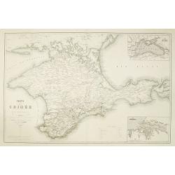
Carte de la Crimée pour suivre les opérations de la Guerre d'Orient.
Uncommon map showing the Crimea region, published to follow the Crimean war. With inset maps "Carte des pays riverains de la Mer Noire" et "Port de Sevasto...
Place & Date: Paris, Ernest Bourdin, 1854
Selling price: $275
Sold in 2010
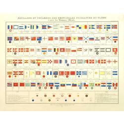
Pavillons et cocardes des principales puissances du globe d'après des Documents Officiels.
Very decorative originally hand colored chart of flags and rosettes of all sea fearing nations, prepared by J. Andriveau-Goujon and published in his "Atlas Universel...
Place & Date: Paris, ca. 1854
Selling price: $325
Sold in 2012

Black Sea - Baljik Bay surveyed by the officers of H.S.M.V. Spitfire 1854
of the Baljik Bay with in top a panoramic view of the town seen from the anchorage. The Baljik Bay is located in Southeastern Europe, bordering the Black Sea, between Ro...
Place & Date: London, after 1854
Selling price: $50
Sold in 2017

Map of Louisiana Representing the Several Land Districts
A handsome and very uncommon map of Louisiana. The work is a detailed survey of the State's various land divisions. A 12 point reference table provides letter coding and ...
Place & Date: Donoldsonville, Louisiana, dated 1855
Selling price: $210
Sold

A Plan of the City of New York & its Environs to Greenwich.
A marvelous re-issue of Major John Montresor's famous and exceedingly scarce official plan of New York. This plan was specially commissioned by George Hayward in 1854 fo...
Place & Date: New York, 1855
Selling price: $480
Sold

Jerusalem.
Very rare bird's eye view of the Holy City of Jerusalem. Engraved in stone by C.Bruder.The town plan is very detailed and has 159 numbers referring to the most important ...
Place & Date: Germany, c. 1855
Selling price: $330
Sold

Grand atlas Universel physique, historique et politique geographie ancienne et moderne.
Atlas with 40 maps of the old and modern world, prepared by CH. Dyonnet . Each map measures about 55x74cm.
Place & Date: Paris 1855
Selling price: $900
Sold
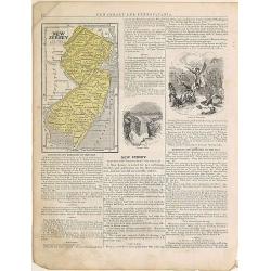
New Jersey.
From: System of Geography for the use of schools , published by Harper and brothers, 329 Pearl Street, New York.Page 37/38 from Sidney E. Morse's: System of Geography for...
Place & Date: New York, 1855
Selling price: $20
Sold in 2015
West India Islands.
This is the uncommon and slightly later edition by Rapkin based on Tallis' maps. The vignettes have been removed and the map is issued in black and white. The map extends...
Place & Date: London 1855
Selling price: $80
Sold
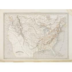
Etats-Unis. . .
Very detailed map of the United States of America, prepared by Auguste Henri Dufour (1798-1865). From La Terre Atlas Historique et Universel de Geographique. Published in...
Place & Date: Paris, 1855
Selling price: $120
Sold in 2020
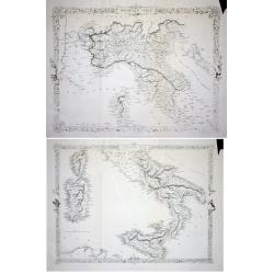
LOT OF 2: Northern Italy & Southern Italy
Lot of 2 maps of the the uncommon and slightly later edition by Rapkin based on Tallis' maps. The vignettes have been removed and the map is issued in black and white. Wi...
Place & Date: London 1855
Selling price: $30
Sold
CHINA and BIRMAH
This is the uncommon and slightly later edition by Rapkin based on Tallis' maps. The vignettes have been removed and the map is issued in black and white.A rare and desir...
Place & Date: London, 1855
Selling price: $60
Sold
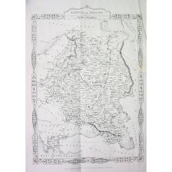
RUSSIA in EUROPE
This is the uncommon and slightly later edition by Rapkin based on Tallis' maps. The vignettes have been removed and the map is issued in black and white. A rare and desi...
Place & Date: London, 1855
Selling price: $50
Sold in 2008

West India Islands
This is the uncommon and slightly later edition by Rapkin based on Tallis' maps. The vignettes have been removed and the map is issued in black and white. The map extends...
Place & Date: London 1855
Selling price: $85
Sold
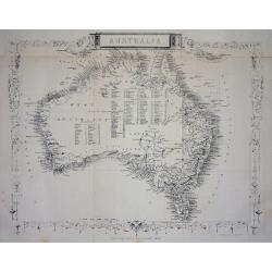
Australia.
This is the uncommon and slightly later edition by Rapkin based on Tallis' maps. The vignettes have been removed and the map is issued in black and white. With decorative...
Place & Date: London 1855
Selling price: $80
Sold
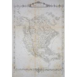
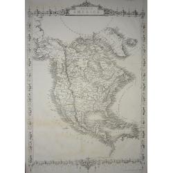
North America.
Important and uncommon later edition by Rapkin based on Tallis' maps. The vignettes have been removed and the map is issued in black and white. With decorative borders an...
Place & Date: London 1855
Selling price: $25
Sold
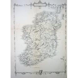
Ireland
This is the uncommon and slightly later edition by Rapkin based on Tallis' maps. The vignettes have been removed and the map is issued in black and white. With decorative...
Place & Date: London 1855
Selling price: $50
Sold

Cape Colony
This is the uncommon and slightly later edition by Rapkin based on Tallis' maps. The vignettes have been removed and the map is issued in black and white.With decorative ...
Place & Date: London, 1855
Selling price: $40
Sold in 2008

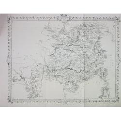
Carte Administrative, Physique et Routière De l'Espagne et du Portugal..
Steel engraving in 2 sheets representing the Iberian peninsula. Surrounded by a decorative frame composed by 32 views of Spanish towns.Title engraved by Ch. Simon.
Place & Date: Paris, 1855
Selling price: $1150
Sold
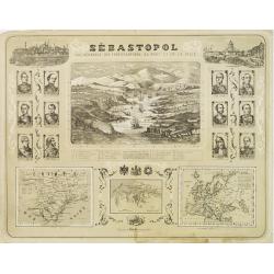
Sébastopol Vue Générale des Fortifications, du Port et de la Ville.
View of Sebastopol and its harbor, from the newspaper Le Siècle whose first issue was published in 1836. Surrounded by 2 views of Istanbul and St. Petersburg in the top ...
Place & Date: Paris ca. 1855
Selling price: $150
Sold

South America western part.
Map of western part of South America. From Sidney E. Morse''s: System of Geography for the use of schools , published by Harper and brothers, 329 Pearl Street, New York.A...
Place & Date: New York, 1855
Selling price: $20
Sold in 2009

Persia and Arabia. / India and Malaysia.
Map of India and Malaysia. On the verso a map of Persia and Arabia (110x140mm.) . From Sidney E. Morse''s: System of Geography for the use of schools , published by Harpe...
Place & Date: New York, 1855
Selling price: $10
Sold in 2011
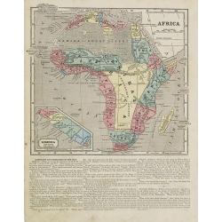
Africa.
Map of Africa. From Sidney E. Morse''s: System of Geography for the use of schools , published by Harper and brothers, 329 Pearl Street, New York.An 150 years old map wit...
Place & Date: New York, 1855
Selling price: $55
Sold in 2008

South America.
Map of the South American continent. From Sidney E. Morse''s: System of Geography for the use of schools , published by Harper and brothers, 329 Pearl Street, New York.An...
Place & Date: New York, 1855
Selling price: $17
Sold in 2009
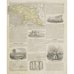
Turkey in Asia.
Map of Turkey. From Sidney E. Morse''s: System of Geography for the use of schools , published by Harper and brothers, 329 Pearl Street, New York.An 150 years old map wit...
Place & Date: New York, 1855
Selling price: $10
Sold in 2009

Italy, Turkey and Greece. / Holland and Belgium.
Map of Italy, Turkey and Greece. From Sidney E. Morse''s: System of Geography for the use of schools , published by Harper and brothers, 329 Pearl Street, New York.An 150...
Place & Date: New York, 1855
Selling price: $20
Sold in 2009

Austria and Prussia.
Map of Austria and Prussia. From Sidney E. Morse''s: System of Geography for the use of schools , published by Harper and brothers, 329 Pearl Street, New York.An 150 year...
Place & Date: New York, 1855
Selling price: $20
Sold in 2008
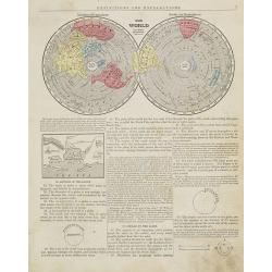
The World Northern & Southern hemisphere.
Map of the world presented in two northern and southern hemispheres. From Sidney E. Morse''''''''s: System of Geography for the use of schools , published by Harper and b...
Place & Date: New York, 1855
Selling price: $25
Sold
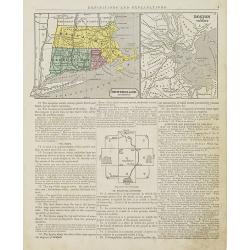
New England Southern Part.
Map of the southern part of New England specifically of Massachusetts, Connecticut and Rhode Island and Boston and its vicinities. On the verso, a world map of North and ...
Place & Date: New York, 1855
Selling price: $10
Sold in 2015

Canada.
Map of Canada. On the verso, a world map of North and South America with its northern and southern hemispheres. From Sidney E. Morse''s: System of Geography for the use o...
Place & Date: New York, 1855
Selling price: $20
Sold in 2015

Ohio and Indiana.
Map of Ohio and Indiana. On verso a map of Iowa, Illinois and Missouri. From Sidney E. Morse''s: System of Geography for the use of schools , published by Harper and brot...
Place & Date: New York, 1855
Selling price: $20
Sold in 2011
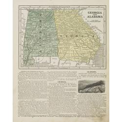
Georgia and Alabama.
Map of Georgia and Alabama. On verso a map of Louisiana, Mississippi and Arkansas. From Sidney E. Morse''s: System of Geography for the use of schools , published by Harp...
Place & Date: New York, 1855
Selling price: $30
Sold in 2010
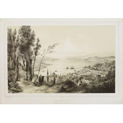
Constantinople - Vue prise de la tour du Séraskir.
Lithography on tinted grounds, with a panoramic view of the Bosphorus, with on foreground Istanbul. Printed by Wild, after a design of Bouquet and drawn on stone by Champ...
Place & Date: Paris, ca 1855
Selling price: $400
Sold in 2013
North America.
Important and uncommon later edition of Tallis map. The vignettes have been removed and the map is issued in black and white. Very detailed with numerous place names and ...
Place & Date: London, c.1855
Selling price: $30
Sold in 2011