Browse Listings

Die Staaten von New York, Pensylvania, Maryland, New Jersey.
Including the states of New York, Pennsylvania, Maryland, New Jersey, Delaware and Virginia. With inset plans of New York, Philadelphia, Niagara Falls, Albany, Pittsburgh...
Place & Date: Hildburghausen & Philadelphia, 1852
Selling price: $22
Sold in 2011

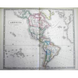
Carte de l'Amerique..
Very detailed map of the western hemisphere, prepared by Auguste Henri Dufour (1798-1865). Published by Mrs. V.Turgis, rue Serpentine in Paris. To the left inset maps of ...
Place & Date: Paris, 1852
Selling price: $170
Sold in 2023
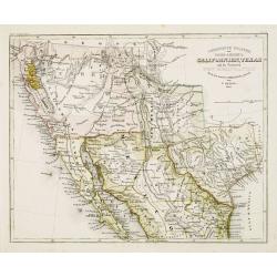
Vereinigte Staaten von Nord-America: Californien, Texas, und die Territorien New Mexico u. Utah.
Gold Regions tinted yellow. Very unusual combination of Texas and New Mexico configuration. California divided into ?Upper California?, which includes the Gold Regions an...
Place & Date: Hildburghausen, 1852
Selling price: $80
Sold
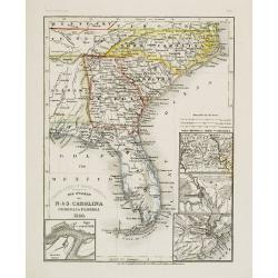
Die Staaten von N. & S. Carolina Georgia & Florida 1850.
Detailed map of Florida, North and South Carolina, with inset maps of St.Augustine, Newberne, Charleston and "Gold region von Nord -Carolina".Major ?roads? show...
Place & Date: Hildburghausen, 1852
Selling price: $80
Sold
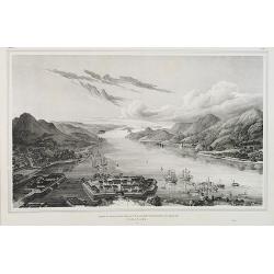
Gezigt op de haven en de baai van Nagasaki.
A birds-eye view showing Deshima, the trading post of the V.O.C., and Nagasaki bay. Von Siebold was born in Würtzburg, in Germany, and worked for the Dutch government as...
Place & Date: Leiden, 1832-1852
Selling price: $3600
Sold in 2010

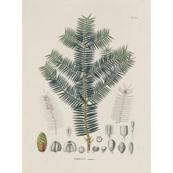
Acer micranthum.
From his famous work 'Flora Japonica'. Von Siebold was born in Würtzburg, in Germany, and worked for the Dutch government as a doctor in Java. In Japan, where Von Siebol...
Place & Date: Leiden, 1852
Selling price: $120
Sold in 2009
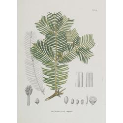
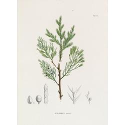
Cephalotaxus drupacea.
From his famous work 'Flora Japonica'. Von Siebold was born in Würtzburg, in Germany, and worked for the Dutch government as a doctor in Java. In Japan, where Von Siebol...
Place & Date: Leiden, 1852
Selling price: $90
Sold in 2009
![Dépt. Des Bes. Du Rhône. N°12. [ Marseille, Arles, Aix ]](/uploads/cache/27091-250x250.jpg)
Dépt. Des Bes. Du Rhône. N°12. [ Marseille, Arles, Aix ]
Map of the region around Marseille, Arles, Aix in the south of France.Lovely map from one of the last decorative atlases of the nineteenth century.The rather simple map i...
Place & Date: Paris, A. Combette, 1852
Selling price: $80
Sold in 2010
![Dépt. De La Charente. N°13. [ Cognac ]](/uploads/cache/27094-250x250.jpg)
Dépt. De La Charente. N°13. [ Cognac ]
Map of the Charente region, centered on Angouleme and Cognac. Home of the world's best-known brandy, the map shows the countryside surrounding the Charente River one hund...
Place & Date: Paris, A. Combette, 1852
Selling price: $50
Sold in 2023
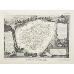
Dépt. De La Corrèze. N°18.
Map of the Corrèze region in France.Lovely map from one of the last decorative atlases of the nineteenth century.The rather simple map is framed by medallion portraits a...
Place & Date: Paris, A. Combette, 1852
Selling price: $30
Sold in 2009
![Dépt. De La Côte D'Or. N°20. [ Lyon ]](/uploads/cache/27099-250x250.jpg)
Dépt. De La Côte D'Or. N°20. [ Lyon ]
Map of the Burgundy area, centered on Lyon.Lovely map from one of the last decorative atlases of the nineteenth century.The rather simple map is framed by medallion portr...
Place & Date: Paris, A. Combette, 1852
Selling price: $50
Sold in 2009
![Dépt. Des Côtes Du Nord. N°21. [ St.Brieuc and St.Malo ]](/uploads/cache/27100-250x250.jpg)
Dépt. Des Côtes Du Nord. N°21. [ St.Brieuc and St.Malo ]
Map of the northern part of Brittany, including the towns of St.Brieuc and St.Malo, Dinan, etc.Lovely map from one of the last decorative atlases of the nineteenth centur...
Place & Date: Paris, A. Combette, 1852
Selling price: $65
Sold
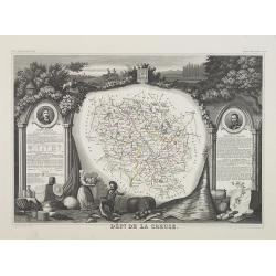
Dépt. De La Creuse. N°22.
Map of the Creuse region in France.Lovely map from one of the last decorative atlases of the nineteenth century.The rather simple map is framed by medallion portraits and...
Place & Date: Paris, A. Combette, 1852
Selling price: $35
Sold in 2009
![Dépt. Du Doubs. N°24. [ Besançon ]](/uploads/cache/27103-250x250.jpg)
Dépt. Du Doubs. N°24. [ Besançon ]
Map of the Doubs region, centered on the town Besançon in France.Lovely map from one of the last decorative atlases of the nineteenth century.The rather simple map is fr...
Place & Date: Paris, A. Combette, 1852
Selling price: $30
Sold in 2009
![Dépt. De La Dordogne. N°25. [ Perigueux ]](/uploads/cache/27104-250x250.jpg)
Dépt. De La Dordogne. N°25. [ Perigueux ]
Map of the Dordogne region, centered on Perigueux in France.Lovely map from one of the last decorative atlases of the nineteenth century.The rather simple map is framed b...
Place & Date: Paris, A. Combette, 1852
Selling price: $50
Sold in 2010
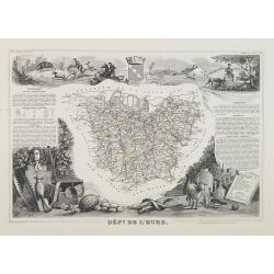
Dépt. De L'Eure. N°26.
Map of the Eure a region in France, including the area south of the River Seine from Vernon to Le Havre.Lovely map from one of the last decorative atlases of the nineteen...
Place & Date: Paris, A. Combette, 1852
Selling price: $30
Sold in 2009
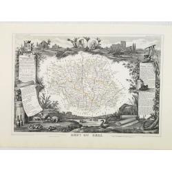
Dépt. Du Gers. N°31.
Map of the Gers region in France.Lovely map from one of the last decorative atlases of the nineteenth century.The rather simple map is framed by medallion portraits and c...
Place & Date: Paris, A. Combette, 1852
Selling price: $50
Sold in 2010
![Dépt. De La Gironde. N°32. [ Bordeaux ]](/uploads/cache/27111-250x250.jpg)
Dépt. De La Gironde. N°32. [ Bordeaux ]
Map of the Gironde region, including Bordeaux in France.Lovely map from one of the last decorative atlases of the nineteenth century.The rather simple map is framed by me...
Place & Date: Paris, A. Combette, 1852
Selling price: $55
Sold in 2009
![Dépt. De L'Hérault. N°33. [ Narbonne, Montpellier ]](/uploads/cache/27112-250x250.jpg)
Dépt. De L'Hérault. N°33. [ Narbonne, Montpellier ]
Map of the Hérault region, including the towns of Narbonne, Montpellier, etc in Southern France.Lovely map from one of the last decorative atlases of the nineteenth cent...
Place & Date: Paris, A. Combette, 1852
Selling price: $30
Sold in 2009
![Dépt. Du Loiret. N°44. [ Orleans ]](/uploads/cache/27123-250x250.jpg)
Dépt. Du Loiret. N°44. [ Orleans ]
Map of the Loire region, centered on the town of Orleans and the region north of the River Loire.Lovely map from one of the last decorative atlases of the nineteenth cent...
Place & Date: Paris, A. Combette, 1852
Selling price: $40
Sold
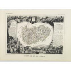
Dépt. De La Meurthe. N°53.
Map of the Meurthe region in France.Lovely map from one of the last decorative atlases of the nineteenth century.The rather simple map is framed by medallion portraits an...
Place & Date: Paris, A. Combette, 1852
Selling price: $50
Sold in 2013
![Dépt. De La Sarthe. N°71. [ Le Mans ]](/uploads/cache/27152-250x250.jpg)
Dépt. De La Sarthe. N°71. [ Le Mans ]
Map of the Sarthe region, centered on Le Mans.Lovely map from one of the last decorative atlases of the nineteenth century.The rather simple map is framed by medallion po...
Place & Date: Paris, A. Combette, 1852
Selling price: $50
Sold in 2010
![Dépt. De Vaucluse. N°81. [ Avignon, Carpentras, Apt ]](/uploads/cache/27161-250x250.jpg)
Dépt. De Vaucluse. N°81. [ Avignon, Carpentras, Apt ]
Map of the Vaucluse region in France, including Avignon, Carpentras, Apt, etc.Lovely map from one of the last decorative atlases of the nineteenth century.The rather simp...
Place & Date: Paris, A. Combette, 1852
Selling price: $50
Sold in 2017
![Dépt. De La Vienne. N°83. [ Poitier ]](/uploads/cache/27164-250x250.jpg)
Dépt. De La Vienne. N°83. [ Poitier ]
Map of the Vienne region in France, centered on the town Poitier.Lovely map from one of the last decorative atlases of the nineteenth century.The rather simple map is fra...
Place & Date: Paris, A. Combette, 1852
Selling price: $30
Sold in 2009
![Dépt. De La Hte. Vienne. N°84. [ Limoges]](/uploads/cache/27165-250x250.jpg)
Dépt. De La Hte. Vienne. N°84. [ Limoges]
Map of the Upper Vienne region, centered on the town Limoges, famous for its porcelain.Lovely map from one of the last decorative atlases of the nineteenth century.The ra...
Place & Date: Paris, A. Combette, 1852
Selling price: $30
Sold in 2009

Colonies Françaises (en Afrique). N°91.
Handsome map divided into two sections shows a section of the coast of French West Africa titled 'Senegambie' (Senegal & Gambia) with a drawing of the Senegal River a...
Place & Date: Paris, A. Combette, 1852
Selling price: $80
Sold in 2009
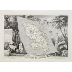
Colonies Françaises Martinique. Amérique du Sud. N°90.
Map of Martinique.A very decorative 19th century map of Martinique Island. The map is surrounded by the products of the island like tobacco, sugar, etc. A decoration of t...
Place & Date: Paris, A. Combette, 1852
Selling price: $90
Sold in 2018
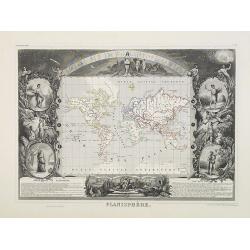
Planisphère. N°93.
World map in Mercator's projection and surrounded by fine steel engravings including vignettes representing the four seasons, allegorical figures of the continents and se...
Place & Date: Paris, A. Combette, 1852
Selling price: $140
Sold in 2009

Europe.
Map of Europe, framed by medallion portraits and coats of arms down each side and is set against a background of statues and allegorical figures. A large group of adorabl...
Place & Date: Paris, A. Combette, 1852
Selling price: $80
Sold in 2009

Amérique Méridionale.
Map of South America.Lovely map from one of the last decorative atlases of the nineteenth century.The rather simple map is framed by horses, Indians, jaguars, tapirs, and...
Place & Date: Paris, A. Combette, 1852
Selling price: $60
Sold in 2009
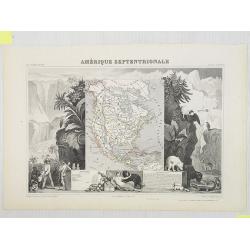
Amérique Septentrionale.
Map of North America showing the Republic of Texas, the United States extends into present-day Canada, Russia is in control of Alaska, and Mexico's northern border is acc...
Place & Date: Paris, A. Combette, 1852
Selling price: $200
Sold in 2009
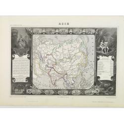
Asie.
Map of Asia framed by vignettes depicting costumes of the various peoples of Asia, Adam and Eve, and several exotic animals. Interesting population chart at right totalin...
Place & Date: Paris, A. Combette, 1852
Selling price: $80
Sold in 2009
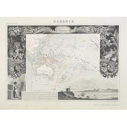
Océanie.
Map of Oceania (Australia, New Zealand, and New Guinea, and all of the Malay Archipelago), divided into four parts. "Malaisie" includes the islands of Southeast...
Place & Date: Paris, A. Combette, 1852
Selling price: $80
Sold in 2009
![[Title page]. Atlas National Illustré des 86 Départements et des Possessions de la France . . .](/uploads/cache/27077-250x250.jpg)
[Title page]. Atlas National Illustré des 86 Départements et des Possessions de la France . . .
Frontispiece of the
Place & Date: Paris, A. Combette, 1852
Selling price: $50
Sold in 2011

Tableau Statistique de la France et de ses Colonies.
Demographic and geographic statistic chart of France and its colonies.From one of the last decorative atlases of the nineteenth century.Victor Levasseur's "Atlas Nat...
Place & Date: Paris, A. Combette, 1852
Selling price: $40
Sold in 2009

France en 1852.
A general map of France in 1852.Lovely map from one of the last decorative atlases of the nineteenth century.The rather simple map is framed by medallions showing stages ...
Place & Date: Paris, A. Combette, 1852
Selling price: $30
Sold in 2009

Podocarpus Nageia.
From his famous work 'Flora Japonica'. Von Siebold was born in Wü:rtzburg, in Germany, and worked for the Dutch government as a doctor in Java. In Japan, where Vo...
Place & Date: Leiden 1852
Selling price: $150
Sold in 2009
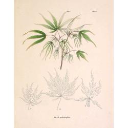
Acer polymorphum.
From his famous work 'Flora Japonica'. Von Siebold was born in Würtzburg, in Germany, and worked for the Dutch government as a doctor in Java. In Japan, where Von Siebol...
Place & Date: Leiden 1852
Selling price: $150
Sold in 2009
IUNIPERUS chinensis. Tab. 126.
From his famous work 'Flora Japonica'. Von Siebold was born in Wurtzburg, in Germany, and worked for the Dutch government as a doctor in Java. In Japan, where Von Siebold...
Place & Date: Leiden, 1852
Selling price: $150
Sold in 2009

IUNIPERUS chinensis. Tab. 127.
From his famous work 'Flora Japonica'. Von Siebold was born in Wurtzburg, in Germany, and worked for the Dutch government as a doctor in Java. In Japan, where Von Siebold...
Place & Date: Leiden, 1852
Selling price: $150
Sold in 2009
IUNIPERUS chinensis. Tab. 129.
From his famous work 'Flora Japonica'. Von Siebold was born in Wurtzburg, in Germany, and worked for the Dutch government as a doctor in Java. In Japan, where Von Siebold...
Place & Date: Leiden, 1852
Selling price: $220
Sold in 2009

IUNIPERUS chinensis. Tab. 126.
From his famous work 'Flora Japonica'. Von Siebold was born in Wurtzburg, in Germany, and worked for the Dutch government as a doctor in Java. In Japan, where Von Siebold...
Place & Date: Leiden, 1852
Selling price: $140
Sold in 2009
IUNIPERUS chinensis. Tab. 127.
From his famous work 'Flora Japonica'. Von Siebold was born in Würtzburg, in Germany, and worked for the Dutch government as a doctor in Java. In Japan, where Von Siebol...
Place & Date: Leiden, 1852
Selling price: $120
Sold in 2009
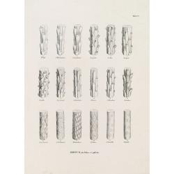
ABIETUM phyllulae et pulvini.s. Tab. 137.
From his famous work 'Flora Japonica'. Von Siebold was born in Würtzburg, in Germany, and worked for the Dutch government as a doctor in Java. In Japan, where Von Siebol...
Place & Date: Leiden, 1852
Selling price: $80
Sold in 2021

CEPHALOTAXUS drupacea. Tab. 131.
From his famous work 'Flora Japonica'. Von Siebold was born in Würtzburg, in Germany, and worked for the Dutch government as a doctor in Java. In Japan, where Von Siebol...
Place & Date: Leiden, 1852
Selling price: $150
Sold in 2009

Het Japansche Ryk. De Voornaamste Eilanden van Hetzelve Zijn. Das Japanische Reich. Die vorzügliehsten Inseln desselben . . . Neben und Schutzländer.
A table prepared by Von Siebold showing the names of the different Japanese islands in Japanese and Latin.Von Siebold was born in Wurzburg, in Germany, and worked for the...
Place & Date: Leiden, 1832-1852
Selling price: $350
Sold in 2010

Japan ten tyde van Zin-mu-ten-woo 660 v.c.
Historical map of Japan for the year 660 B.C., during the regime of Zin-mu-ten-woo. According to the map Japan was known as "Jama-to v. Aki-Tsu-Sima.The tip of Korea...
Place & Date: Leiden 1832-1852
Selling price: $500
Sold in 2014

Nouvelle Carte de France indiquant les Routes de Poste . . .
post road mapsPost route map of France with two inset maps, one of Paris upper left corner, and one of Corsica lower left corner. Prepared by the geographer Charle and pu...
Place & Date: Paris, A. Combette, 1852
Selling price: $100
Sold

Muzijkinstrumenten - Samisen / Kokiu.
A japanese woman playing the samisen and a men playing kokiu.Von Siebold was born in Würtzburg, in Germany, and worked for the Dutch government as a doctor in Java. In J...
Place & Date: Leiden, 1832-1852
Selling price: $450
Sold in 2012
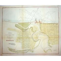
Survey of the Harbor of Cleveland Ohio..
An interesting and finely executed mid 19th century harbour survey and town plan of Cleveland. This lithographic work details the Cuyahoga River and topography of the cit...
Place & Date: New York, ca 1853
Selling price: $240
Sold
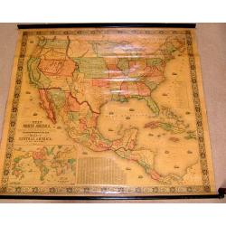
New Map of that Portion of North America Exhibiting..
Full title: New Map of that Portion of North America Exhibiting the United States and Territories, the Canada's, New Brunswick, Nova Scotia and Mexico, also Central Ameri...
Place & Date: Baltimore 1853
Selling price: $2600
Sold
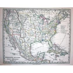
Vereinigte Staaten von Nord America und Mexico
Famous German steel-engraved map of the United States and Latin America, published in Stieler's Schul-Atlas. Includes much topographical detail and curiously shaped state...
Place & Date: Gotha, c. 1853
Selling price: $95
Sold

Afrique/Publiee par Logerot.
Original map on steel drawn by A. R. Frémin, engraved by Ch. Dyonnet, published by Logerot.
Place & Date: Paris, 1853
Selling price: $60
Sold in 2008

General-karte von der Europäischen Türkei nach allen vorhandenn originalkarten und itinerarischen hülfsmitteln bearbeitet und von Heinrich Kiepert
Map of present-day Greece and Turkey.
Place & Date: Berlin, Dietrich Reimer, 1853
Selling price: $490
Sold in 2008

United States and Canada 1853
The first Map Hitcheock,s landmark map of 1853 which is unchanged from the first edition of this report.
Place & Date: Boston, 1853
Selling price: $1500
Sold

Plan Itinéraire De Paris.
Folding plan of Paris divided into numbered and lettered squares, corresponding indices of streets and public buildings to left and right edges. Original color in block a...
Place & Date: Paris: J. Andriveau-Goujon, 1853
Selling price: $120
Sold in 2012
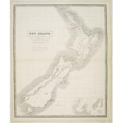
New Zealand by A.K. Johnston F.R.G.S.
Map of New Zealand, with notes, and with "the southern part of the North I. corrected from recent surveys by Mr Kettle, Assist. Surveyor to the N.Z. Co., Oct. 1843.&...
Place & Date: Edinburgh, ca. 1853
Selling price: $120
Sold in 2023

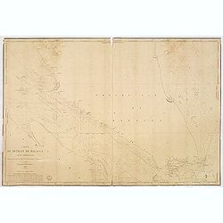
Carte du détroit de Malacca. Partie Septentrionale comprenant depuis Poulo Penang jusqu'au Mont Parcelar. . .
Detailed chart depicting the strait of Malacca and the north west coast of Malaysia, from the island Pulau Pinang to Pelabuhan Klang west of Kuala Lumpur.With inset chart...
Place & Date: Paris, 1843 updated to 1853
Selling price: $1050
Sold in 2013
Carte du détroit de Malacca. Partie Méridionale comprenant depuis le Mont Parcelar jusqu'à Singapoure.
Detailed chart depicting the strait of Malacca and the southern tip of Malaysia, including the island Singapore.The chart was actually used and has some lead pencil annot...
Place & Date: Paris, 1843 updated to 1853
Selling price: $525
Sold in 2013
America.
Large and detailed map of the Western Hemisphere. With "New California" labeled Russian America (Alaska) La Plata (pre Argentina) Unfinished coasts ...
Place & Date: Liverpool, 1853
Selling price: $35
Sold in 2013
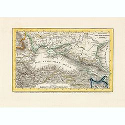
Küstenländer des Schwarzen Meeres.
Detailed steel engraved miniature map of the Black Sea region. The map was prepared and engraved by Lieutenant L. Renner., who was a military officer, recruited by Joseph...
Place & Date: Hildburghausen / Amsterdam / Philadelphia, 1853
Selling price: $30
Sold in 2014
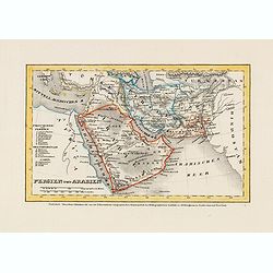
Persien und Arabien.
Detailed steel engraved miniature map of the Arabia Pen insular and Persia. The map was prepared and engraved by Lieutenant L. Renner., who was a military officer, recrui...
Place & Date: Hildburghausen / Amsterdam / Philadelphia, 1853
Selling price: $30
Sold in 2014

Britische colonien von Süd Africa.
Detailed steel engraved miniature map of South Africa, with inset of Cape Town. The map was prepared and engraved by Lieutenant L. Renner., who was a military officer, re...
Place & Date: Hildburghausen / Amsterdam / Philadelphia, 1853
Selling price: $30
Sold in 2015
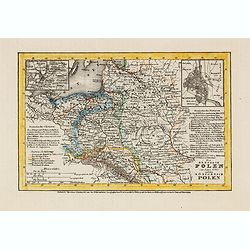
Die Republik Polen (im Jahre 1772) und das Königreich Polen.
Detailed steel engraved miniature map of South Africa, with inset maps of Vilnius and Warschau. The map was prepared and engraved by Lieutenant L. Renner., who was a mili...
Place & Date: Hildburghausen / Amsterdam / Philadelphia, 1853
Selling price: $30
Sold in 2014
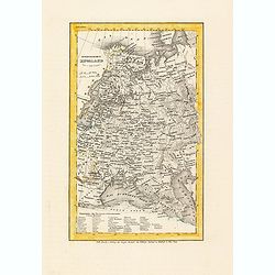
Europaeisches Russland.
Detailed steel engraved miniature map of Russia, prepared by Radefeld. The map was engraved by Lieutenant L. Renner., who was a military officer, recruited by Joseph Meye...
Place & Date: Hildburghausen / Amsterdam / Philadelphia, 1853
Selling price: $30
Sold in 2014

New Zealand.
Nice hand-colored lithograph map of New Zealand engraved by W. Hughes and published in Edinburgh by A. & C. Black in 1853. The map features insets of Tasmania and Wes...
Place & Date: Edinburgh, 1853
Selling price: $24
Sold in 2016

The Rights of Women or the Effects of Female Enfranchisement.
Hand-colored satirical etching by illustrator & cartoonist, George Cruikshank and issued in his "THE COMIC ALMANAC" for 1853.Features one of the early polit...
Place & Date: London, 1853
Selling price: $145
Sold in 2017

Posesiones de America : Isla de Cuba. . .
Wall size map of land areas showing all of Cuba, part of Florida Keys plus San Adios and Salvador Grande in the Bahamas.Minute topographical, political, and hydrographic ...
Place & Date: Madrid, 1853
Selling price: $750
Sold in 2023
Baltic Gulf of Finland KRONSTAT from the Russian survey . . .
Large scale chart of the island of Kronstat in the Gulf of Finland. With also coast of Finland. With soundings, scale and vignette of Hydrographical office. Chart nr. 221...
Place & Date: London, 1853
Selling price: $250
Sold in 2021

Der Atlantische Ocean
A very interesting map of the Atlantic Ocean, showing several routes (with dates) between Europe and the Americas. Includes the tracks of Columbus' first voyage, Humboldt...
Place & Date: Gotha, 1853
Selling price: $32
Sold in 2016
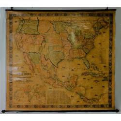
New Map of the Portion of North America, Exhibiting the United States and Territories, The Canadas, New Brunswick, Nova Scotia, and Mexico also Central America, and the West India Islands.
Possibly the most interesting and attractive 19th-century wall map of North America. Published in 1853 by Jacob Monk, this large and beautiful wall map details much of No...
Place & Date: Baltimore, 1853
Selling price: $1840
Sold in 2018
Carte particulière des cotes d'Italie (Grand Duché de Toscane). . .
Large chart showing the coast of Tuscany with the town of Cala Di Forno and Talamone. Engraved by V. Carré and J.M.Hacq.
Place & Date: Paris, 1853
Selling price: $60
Sold in 2018
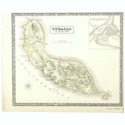
A detailed map of the island of Curaçao.
A detailed map of the island of Curaçao showing settlements, roads, and the topography. An inset shows Fort Amsterdam with the battery, gallows, and fortifications.
Place & Date: Liverpool, George Philip and Son, 1853
Selling price: $100
Sold in 2022

Map of the Valley of the Amazon To Accompany Lt. Herndon's Report.
This is one of three maps that accompanied Herndon's report, “Exploration of the Valley of the Amazon”. In 1851, Lieutenant Herndon was commissioned to lead the first...
Place & Date: Baltimore, 1853
Selling price: $47
Sold in 2018

Stretto di Gibilterra.
The bottom half of a two view sheet by Corbetta. (The missing view is that of the Dardanelles in Turkey.) This colored view is that of the Strait of Gibraltar. With Itali...
Place & Date: Milano, 1853
Selling price: $65
Sold in 2020
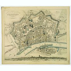
Frankfort.
A detailed plan of the German city of Frankfort, published by the Society for the Diffusion of Useful Knowledge. Streets and prominent buildings shown in great detail, to...
Place & Date: London, 1853
Selling price: $30
Sold in 2020

A set of 10 humorous prints from the Russian Empire's war with French and British Empire's. c1854.
Ten humorous prints with the following titles: 1.The United Service 18542. The Soldiers Dream 18543. The Shooting Season 18544. God Defend The Right 18545. You Are reques...
Place & Date: London, 1854
Selling price: $120
Sold in 2012

A set of 15 humorous prints from the Russian Empire's war with French and British Empire's. c1854.
Mostly engraved by Joseph Swain. Joseph Swain was one of the most important wood engravers of his time. Punch was responsible for the word sense "cartoon" as a ...
Place & Date: London, 1854
Selling price: $120
Sold in 2012

A set of 10 humorous prints from the Russian Empire's war with French and British Empire's. c1854
1.Peace or War – Anyhow he Must Pay the Bill 18542.Brothers in Arms 18543.Smoke 1854 4.A Struggle Between Duty and Inclination 1854 5.The Holiday Letter 18546.Sebastopo...
Place & Date: London, 1854
Selling price: $120
Sold in 2012
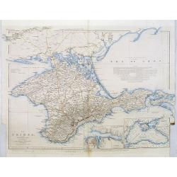
The Crimea, chiefly from surveys made by order of the Russian government. . .
Map of Crimea and the Sea of Azov. In lower right corner two inset maps showing Sebastopol inlet and harbour and a second one with the Black Sea. This second maps shows t...
Place & Date: London, 1854
Selling price: $300
Sold in 2012