Browse Listings
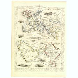
Overland Route to India.
Decorative steel engraved map of the Overland Route to India, surrounded 8 decorative vignettes.Taken from "The illustrated atlas and modern history of the world by ...
Place & Date: London, 1851
Selling price: $90
Sold in 2020

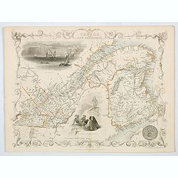
British America.
A decorative and useful map of modern day Canada, when it was still under British rule in the mid nineteenth century. Provinces are outlined in red, with additional annot...
Place & Date: London, 1851
Selling price: $75
Sold in 2022
China and Birmah.
A highly decorative and detailed map of China and Burma which was drawn and engraved by J. Rapkin (vignettes by A. H. Wray & J. B. Allen).Showing British Factories in...
Place & Date: London, Edinburgh & Dublin 1851
Selling price: $195
Sold in 2019
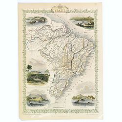
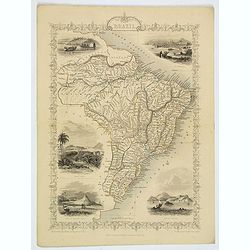
Brazil.
A highly decorative and detailed map of Brazil which was drawn and engraved by J. Rapkin (vignettes by H. Winkles & W. Lacey ). Showing Boats on Lake Negro, Monte Vid...
Place & Date: London, Edinburgh & Dublin 1851
Selling price: $55
Sold in 2020

Cape Colony.
The five vignettes show: Cape Town, Graham's Town, the entrance to the Knysna, native people and a lion.
Place & Date: London, Edinburgh, Dublin, 1851
Selling price: $90
Sold in 2019

Natal and Kaffraria.
Tallis' map of Natal and Kaffraria, with vignettes of Port Natal and Durban atlas. This map was printed from a steel engraving by John Rifkin for Tallis’s The Illustrat...
Place & Date: London, 1851
Selling price: $25
Sold in 2020

Cabool, the Punjab and Beloochistan.
A decorative steel engraved map of Cabool, the Punjab and Beloochistan, surrounded 3 large, colored, decorative vignettes.Taken from "The illustrated atlas and moder...
Place & Date: London, 1851
Selling price: $78
Sold in 2020

West Canada.
This is John Tallis’ attractive map of West Canada. The map is surrounded by a number of topical steel engraved vignettes, including Niagara Falls, Kingston, Indians, B...
Place & Date: London, 1851
Selling price: $58
Sold in 2018

Polynesia or Islands in the Pacific Ocean.
A decorative and attractive map of the Islands in the Pacific Ocean. The map extent shows parts of California, Papua New Guinea, eastern Australia, and southern Japan.The...
Place & Date: London ,1851
Selling price: $75
Sold in 2019

Northern India.
Decorative steel engraved map of Northern India, surrounded 6 decorative vignettes.Taken from "The illustrated atlas and modern history of the world by John Tallis&q...
Place & Date: London, 1851
Selling price: $45
Sold in 2020
Turkey in Europe.
A striking map of European Turkey by John Tallis. It features decorative vignettes of Ali Pasha, The Bosphorus and Constantinople and a Greek Caloyer figure. There is als...
Place & Date: London, 1851
Selling price: $65
Sold in 2019
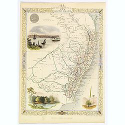
New South Wales.
A decorative steel engraved map of New South Wales, surrounded by illustrations of Sydney Cove, native trees and the seal of New South Wales. Interlocking border design. ...
Place & Date: London, ca 1851
Selling price: $55
Sold in 2020

Nova Scotia and Newfoundland.
A decorative and attractive map of the Canadian provinces of Nova Scotia and Newfoundland. The map is enhanced by the seals of both provinces, plus delightful vignettes o...
Place & Date: London, 1851
Selling price: $48
Sold in 2020

Carte d'une partie des Cotes Orientales de L'Amerique Meridionales. . .
A large marine chart of the eastern coast of Argentina, from the mouth of the River Plate, south to the Gulf of St. George. Filled with nautical information depth levels,...
Place & Date: Paris, 1851
Selling price: $70
Sold in 2019
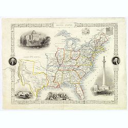
United States.
This is John Tallis’ pretty map of the United States, published mid nineteenth century. The map is surrounded by a number of delightful steel engraved vignettes and the...
Place & Date: London, 1851
Selling price: $60
Sold in 2018

West Canada.
This is John Tallis’ attractive map of West Canada. The map is surrounded by a number of topical steel engraved vignettes, including Niagara Falls, Kingston, Indians, B...
Place & Date: London, 1851
Selling price: $48
Sold in 2019
Brazil.
A highly decorative and detailed map of Brazil which was drawn and engraved by J. Rapkin (vignettes by H. Winkles & W. Lacey ). Showing Boats on Lake Negro, Monte Vid...
Place & Date: London, Edinburgh & Dublin 1851
Selling price: $17
Sold in 2021
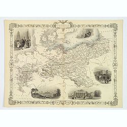
Prussia.
A nice example of this marvelous map of Prussia, surrounded by five decorative vignettes. They include the French Church in Berlin, Frederick the Great, The Royal Palace,...
Place & Date: London, 1851
Selling price: $30
Sold in 2019
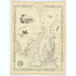
Part of South Australia.
A decorative steel engraved map of the southern part of South Australia, surrounded by illustrations of Adelaide, natives on a catamaran, the seal of the state, an Austra...
Place & Date: London, ca. 1851
Selling price: $35
Sold in 2020
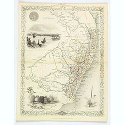
New South Wales.
A decorative steel engraved map of New South Wales, surrounded by illustrations of Sydney Cove, native trees along the Murray River, 'black boy' trees, and the seal of Ne...
Place & Date: London, ca 1851
Selling price: $45
Sold in 2019
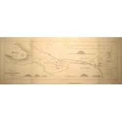
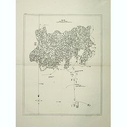
General Plan of the Antiquities of Stenness, Orkney.
General Plan of the Antiquities of Stenness and Orkney. Interesting map that covers the lochs and profiles the stones and Mees of Stenness. Drawn and engraved by James ...
Place & Date: London, 1851
Selling price: $11
Sold in 2019
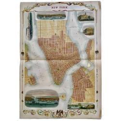
New York.
Rare, double page map of New York by John Tallis with 6 beautiful vignettes. Includes vignettes of City Hall, the Custom's House, the Narrow's from Fort Hamilton, a New ...
Place & Date: London, 1851
Selling price: $350
Sold in 2019
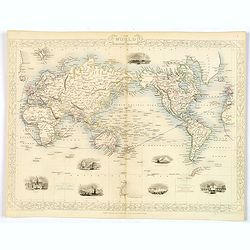
The World on Mercator's Projection.
Drawn & engraved by John Rapkin for "The Illustrated Atlas and Modern History of the World" by Montgomery Martin. Published London 1851 by The London Printi...
Place & Date: London, 1851
Selling price: $88
Sold in 2023
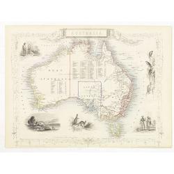
Australia.
Decorative steel engraved map of Australia, surrounded by illustrations of Sydney harbor, birds, kangaroos and local people. Interlocking border design. Taken from "...
Place & Date: London, ca. 1851

Wa-Em-Boesh-Kaa, A Chippeway Chief
A beautifully defined lithograph of a Chippewa chief, from Mckeeney and Hall?s Indian Tribes of North America, perhaps the most important work ever published on North Ame...
Place & Date: Philadelphia, ca.1851
Selling price: $260
Sold
![[LOT OF 4 MAPS] Parts of Australia.](/uploads/cache/92569-250x250.jpg)
[LOT OF 4 MAPS] Parts of Australia.
Set of four highly decorative maps of Australia: 1) Western Australia - Swan River 2) New South Wales 3) Part of South Australia 4) Victoria or Port Phillip The Tallis ...
Place & Date: London/New York, c1851
Selling price: $217
Sold in 2013
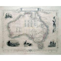
AUSTRALIA.
Great steel engraved map of Australia, with decorative vignettes of Australian Parrots, Aborigines, Kangaroos, and a view Sydney. A very accurate and detailed map, inclu...
Place & Date: London / New York, c1851
Selling price: $380
Sold in 2013
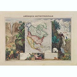
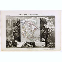
Amérique Septentrionale
Important French map of North America, showing Texas as an independent republic. The population table lists Texas with 200.000 and the United States with 19.000.000 inhab...
Place & Date: Paris 1851
Selling price: $200
Sold in 2008

Neueste Karte von Lousiana.
This highly attractive work is from the German edition of the Tanner / Mitchell Louisiana map, forming part of the NEW UNIVERSAL ATLAS. It shows a German title with place...
Place & Date: Hidleburgh, dated 1851
Selling price: $200
Sold in 2011
Carte de l'Amerique du Nord...
Excellent detailed map of North America, including early western Territorial borders : only OR, CA, NM, UT, TX and NE in the west as well as Russian America.Nice detail t...
Place & Date: Paris, 1851
Selling price: $150
Sold in 2019
![[Title page] Atlas National Illustré des 86 Départements et des Possessions de la France . . .](/uploads/cache/29518-250x250.jpg)
[Title page] Atlas National Illustré des 86 Départements et des Possessions de la France . . .
Frontispiece of the
Place & Date: Paris, A. Combette, 1851
Selling price: $30
Sold in 2010

British possessions in the Mediterranean.
Decorative steel engraved map of the islands and possessions Gibraltar, Malta, Gozo, Corfu, Paxo, Cerigo, Zante, Cephalonia, Ithaca and Maura. Illustrations sit amongst t...
Place & Date: London, ca. 1851
Selling price: $375
Sold

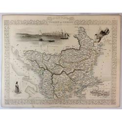
Turkey in Europe.
Decorative steel engraved map of Albania, Macedonia, Romania, Bulgaria, Moldavia and the European part of Turkey with insets of the Bosporus and Constantinople and depict...
Place & Date: London, ca. 1851
Selling price: $230
Sold in 2011
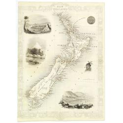
New Zealand.
Decorative steel engraved map of New Zealand, surrounded by illustrations of Auckland, Mount Egmont, a New Zealander, and the port of Wellington. Border in a New Zealand ...
Place & Date: London, 1851
Selling price: $500
Sold in 2010
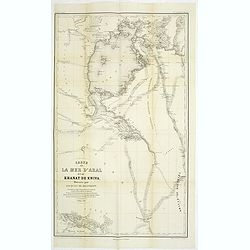
Carte de la Mer d'Aral et du Khanat de Khiva Dressée par Jacques de Khanikoff. . .
Detailed map of The Aral Sea according to Khanikoff. Khanikoff was advisor for the Russian foreign ministry of the Emperor. The map included the travel route of Mouratief...
Place & Date: Paris, 1851
Selling price: $310
Sold in 2011
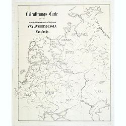
Orientirungs-Carte über die bestehenden und vorgechlagenen Canalverbindungen Russlands.
Uncommon map of the European part of Russia, showing the existing and proposed Canal system. Published in "Allgemeine Bauzeiting".The Allgemeine Bauzeitung was ...
Place & Date: Vienna, 1851
Selling price: $100
Sold in 2011

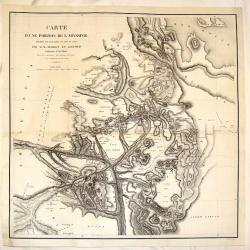
Mouth of Columbia River...
Large and very detailed chart of the Columbia River entering the Pacific Ocean near Astoria, Oregon. With numerous depth soundings and observations on the approach. I...
Place & Date: United States, 1851
Selling price: $37
Sold in 2011

Cape Colony.
A detailed map of the "Cape Colony" of South Africa. It is surrounded by a decorative borders and included vignettes depicting the entrance to the Knysna, Graha...
Place & Date: London, 1851
Selling price: $110
Sold in 2020
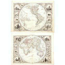
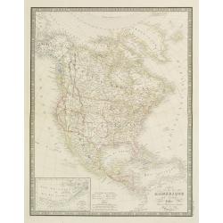
Western Hemisphere / Eastern Hemisphere.
A decorative pair of steel engraved maps of both the Western Hemisphere (The Americas, Pacific Islands, NZ), and the Eastern Hemisphere (the rest of the world), both surr...
Place & Date: London, 1851
Selling price: $255
Sold in 2020
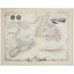
Nova Scotia and Newfoundland.
Double page steel engraved map, accompanied by vignette illustrations of Halifax and cod fishing off Newfoundland. Decorative scrolling and title cartouche around the edg...
Place & Date: London & New York: John Tallis & Company, 1851
Selling price: $64
Sold in 2023
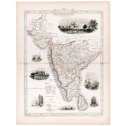
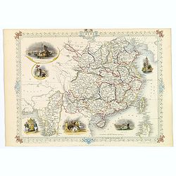
Southern India.
Original steel engraved map of Southern India. Several vignette scenes, including Shuhur, Jeypoor, Calcutta and Bejapoor. Decorative scrolling and title cartouche around ...
Place & Date: London, Edinburgh & Dublin: J & F Tallis, 1851
Selling price: $100
Sold in 2020

Vue Generale du Niagara a Vol d'Oiseau.
A spectacular view of Niagara Falls, the Horseshoe Falls in the foreground looking upstream towards Lake Erie. It was lithographed by Eugene Ciceri (1813 -90) after the v...
Place & Date: Paris, ca 1851
Selling price: $150
Sold in 2021

Jamaica
Fantastic map of Jamaica from the famous Atlas by John Tallis & company published in London & New York around 1850.It shows the island in great detail, filled wit...
Place & Date: London & New York, c1851
Selling price: $44
Sold in 2021

New South Wales
Very decorative and important map of NSW with Sydney, extending north until todays Brisbane and Gold Coast area. Shows many place names, and also with good inland detail!...
Place & Date: London & New York, c1851
Selling price: $35
Sold in 2021
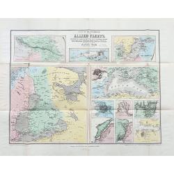
Scene of the operations of the Allied Fleets.
Scarce folding map with 11 maps showing various parts and cities. Including Caucasian Isthmus, Kronstadt, the Baltic Sea, Black Sea, St. Petersburg, the mouth of the Danu...
Place & Date: London, ca. 1851
Selling price: $100
Sold in 2023

South America.
This is John Tallis’ pretty map of South America. The map is surrounded by a number of topical steel engraved vignettes and the whole is surrounded by a decorative vine...
Place & Date: London, 1851
Selling price: $50
Sold in 2023
East Canada and New Brunswick.
This is John Tallis’ map of East Canada, or what is now Quebec and New Brunswick. Includes Montreal, Quebec City, and the St. Lawrence River valley. Features four vigne...
Place & Date: London, 1851
Selling price: $45
Sold in 2023

E and F (combined) Diagram of the State of Missouri.
Detailed land map of the state of Missouri, prepared by John G. Clark, William Dunn, William Shields and Aaron Snider and published by the Office of the surveyor general.
Place & Date: Washington, 1852
Selling price: $50
Sold in 2021
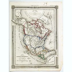
Carte de L'Amerique Septentrionale dresee et dessinee
An uncommon map of North America by J. G. Barbie du Bocage. It shows all of North America from the Arctic Circle to the northern most parts of South America. The US is sh...
Place & Date: PARIS, 1852
Selling price: $60
Sold in 2020

KOORAI. Kumtsjun. Nippon VII. TAB. VIII.
Kumtsjun from Korea, lithography from his very rare book "Nippon".Philipp Franz von Siebold (1796-1866) was a physician, researcher and teacher who joined the D...
Place & Date: Leiden, 1852
Selling price: $600
Sold

KOORAI. Hosatsem. Nippon VII. TAB. IX.
Hosatsem from Korea, lithography from his very rare book "Nippon".Philipp Franz von Siebold (1796-1866) was a physician, researcher and teacher who joined the D...
Place & Date: Leiden, 1852
Selling price: $600
Sold
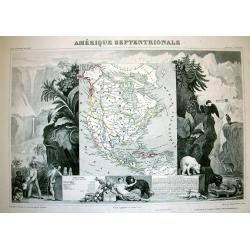
Amérique Septentrionale.
A very decorative map with the Republic of Texas, the United States extending into present-day Canada, Russia in control of Alaska, and Mexico's northern border according...
Place & Date: Paris, A.Combette, ca. 1852
Selling price: $190
Sold in 2013
Carte D'Une Portion de L'Abyssinie
Large, detailed, rare map of the coast of Abyssinia, Egypt, Ethiopia, Somalia and the Red Sea. The cartographers were M.M. Ferret and Galinier, the engraver was Henry Coo...
Place & Date: Paris, 1852
Selling price: $220
Sold in 2013
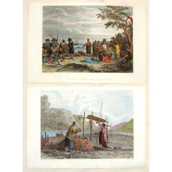
(2 Engravings) Interview of Massacoit with the Pilgrims and Feeding the Dead.
Two steel engravings featuring life among Native Americans in the early times. From "History of the Indian Tribes of the United States", published by Lippincott...
Place & Date: Philadelphia, 1852
Selling price: $17
Sold in 2016
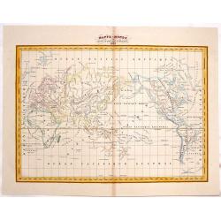
Mappe-Monde.
A pleasant world map centered on the Pacific Ocean. Original O/L coloring.
Place & Date: Paris, 1852
Selling price: $30
Sold in 2015
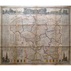
Belgique divisée en provinces et arrondissemens. . .
Scarce large size map of Belgium and Luxembourg, by D. Raes, and engraved by De Lahoese.The map is surrounded by views of important buildings, calenders of the years 1855...
Place & Date: Bruxelles, c1852
Selling price: $209
Sold in 2014
Tab IV. Insulae Nippon partem septentrionalem repraesentans.
Fine map of the most northern part of Honshu, including Fukushima, the island of Sado island.One of the few large scale maps, of Japan included in the rare work by Von Si...
Place & Date: Leiden, 1832-1852
Selling price: $450
Sold in 2016
Tab III. Insulae Nippon partem orientalem repraesentans.
Fine map of the eastern part of Honshu, including Tokyo, Yokohama, Chiba, Shizuoka, Saitama and as far east as Izu Islands.One of the few large scale maps of Japan includ...
Place & Date: Leiden, 1832-1852
Selling price: $450
Sold in 2016

The Bloomers in Hyde Park.
Hand-colored satirical etching by illustrator & cartoonist, George Cruikshank and issued in his "THE COMIC ALMANAC" for 1852.This etching features men and w...
Place & Date: London, 1852
Selling price: $159
Sold in 2016

Curacao to Holland.
A detailed map of the island of Curaçao
Place & Date: Liverpool, 1852
Selling price: $70
Sold in 2016
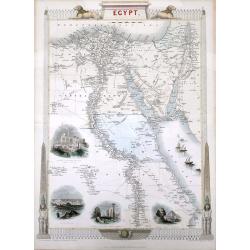
Egypt, and Arabia Petraea
A highly decorative and detailed mid-19th century map of Egypt. Very detailed with many places named along the Nile river, and several Oasis shown, complete with vignette...
Place & Date: London, ca 1852
Selling price: $85
Sold in 2016
![Maury's wind & current chart 3rd edition 1849. no.8 series A. [with] Maury's wind & current chart 3rd edition 1852. no.2 series A. [with] Storm and rain chart of the north Atlantic. . .](/uploads/cache/39424-250x250.jpg)
Maury's wind & current chart 3rd edition 1849. no.8 series A. [with] Maury's wind & current chart 3rd edition 1852. no.2 series A. [with] Storm and rain chart of the north Atlantic. . .
Three rare charts with winds and currents in the North Sea and Atlantic Ocean. - Maury's wind & current chart 3rd edition 1849. no.8 series A. - Maury's wind & c...
Place & Date: USA, 1849, 1852
Selling price: $300
Sold in 2017

MUZJIKINSTRUMENTEN. MUSIKINSTRUMENTE. Tab.V.
Several Japanese instruments.Philipp Franz von Siebold (1796-1866) was a physician, researcher and teacher who joined the Dutch East Indian army and travelled to Japan on...
Place & Date: Leiden, 1852
Selling price: $200
Sold in 2021
Amerique Septentrionale.
Beautiful map with the United States extending into present day Canada, Russia in control of Alaska and Mexico's northern border according to the Treaty of 1810. Surround...
Place & Date: Paris, A. Combette, 1852
Selling price: $120
Sold in 2019

Sud America.
A lovely large map of South America, nicely colored by the newly formed independent countries, with a legend and mileage scales. With good map detail and competently engr...
Place & Date: Weimar, ca 1852
Selling price: $25
Sold in 2020
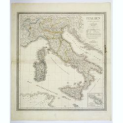
Italien.
A lovely large map of Italy, nicely colored, with a population legend and mileage scales. With plenty of good map detail and competently engraved. Inset of Malta and Gozo...
Place & Date: Weimar, ca 1852
Selling price: $65
Sold in 2018
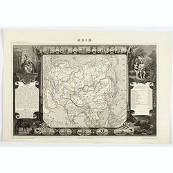
Asie.
A decorative map of Asia framed by glorious vignettes depicting costumes of the various peoples of Asia Adam and Eve, and several exotic animals. With an interesting popu...
Place & Date: Paris, 1852
Selling price: $52
Sold in 2019
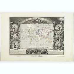
Planisphère.
One of the last decorative maps of the world. In side panels there are representations of the four seasons. In original outline. color, from Levasseur's "Atlas Unive...
Place & Date: Paris, 1852
Selling price: $75
Sold in 2019

Neueste Karte von Mississippi..
Detailed map of the state Mississippi with numerous physical and political features including mines, settlements, trails/roads, forts and Indian areas. From "Meijers...
Place & Date: Hildburghausen/ Philadelphia 1852
Selling price: $100
Sold

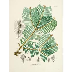
Araucaria excelsa.
"From his famous work ''Flora Japonica''. Von Siebold was born in Würtzburg, in Germany, and worked for the Dutch government as a doctor in Java. In Japan, where Vo...
Place & Date: Leiden 1852
Selling price: $120
Sold in 2012
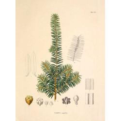
Taxus cuspidata.
"From his famous work 'Flora Japonica'. Von Siebold was born in Würtzburg, in Germany, and worked for the Dutch government as a doctor in Java. In Japan, where Von ...
Place & Date: Leiden 1852
Selling price: $110
Sold in 2009

New Orleans from the Lower Cotton Press
A beautifully defined panoramic view of New Orleans as seen in the late 1840s / early 1850s. The harbor scene depicts numerous sailing ships, steamboats and other vessels...
Place & Date: New York, 1852
Selling price: $100
Sold
![[Untitled Map of Africa]](/uploads/cache/23279-250x250.jpg)
[Untitled Map of Africa]
Fine manuscript map of Africa with relief shown pictorially. Signed by the author in the lower right corner.Lower left Décembre 1852.
Place & Date: Paris, 1852
Selling price: $160
Sold

Amérique.
Fine manuscript map of America with relief shown pictorially. Inset map of Central America called Guatemala in the left hand side.Signed by the author in the lower right ...
Place & Date: Paris, 1852
Selling price: $400
Sold in 2017

Araucaria Cuninghamii.
From his famous work 'Flora Japonica'. Von Siebold was born in Würtzburg, in Germany, and worked for the Dutch government as a doctor in Java. In Japan, where Vo...
Place & Date: Leiden 1852
Selling price: $150
Sold in 2012
Cephalotaxus drupacea.
From his famous work \'Flora Japonica\'. Von Siebold was born in Wurtzburg, in Germany, and worked for the Dutch government as a doctor in Java. In Japan, where Von Siebo...
Place & Date: Leiden 1852
Selling price: $100
Sold in 2009

Torreya nucifera.
From his famous work \'Flora Japonica\'. Von Siebold was born in Würtzburg, in Germany, and worked for the Dutch government as a doctor in Java. In Japan, where Von Sieb...
Place & Date: Leiden 1852
Selling price: $100
Sold in 2009

Portrait of Otaksa.
Fine portrait of Otaksa, published in Nippon . Von Siebold was born in Wurtzburg, in Germany, and worked for the Dutch government as a doctor in Java. In Japan, where Von...
Place & Date: Leiden, 1832-1852
Selling price: $250
Sold in 2009

Amerique Meridionale.
A decorative map of South America from levasseur's 'Atlas national Illustre des 86 Departements et des possesions de la France'.
Place & Date: Paris, 1852
Selling price: $100
Sold

Geographische Wercke aus dem Verlag von Justus Perthes in Gotha. Januar 1852.
A very rare publicity leaflet for atlases published by Justus Perthes in 1852. This leaflet is very valuable as it gives in detail the different atlasses published in 185...
Place & Date: Gotha, 1852
Selling price: $150
Sold