Browse Listings

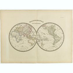
Océanie.
A large and detailed map of Australasia, with insets of New South Wales and the south west corner of Australia. An uncommon map including Australia, New Zealand and Indon...
Place & Date: Paris, ca 1850
Selling price: $40
Sold in 2017

Sir Francis Drake O.B. 1596
A fine steel engraving by Freeman from an original painting. It was published by Fullerton & Co. in Glasgow around 1850.Sir Francis Drake, circa 1540-1596, was an Eng...
Place & Date: Glasgow, ca. 1850
Selling price: $10
Sold in 2017
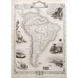
South America.
A detailed map of South America from the famous atlas by John Tallis. With many place names, regions, and countries shown. A highly decorative map with ornamental borders...
Place & Date: London, ca. 1850
Selling price: $70
Sold in 2017

Peru & Bolivia.
A very decorative steel-engraved map extending from Guayaquil southwards until the Atacama. Very detailed with place names, rivers, hills, bays, etc.Attractively illustra...
Place & Date: London, ca. 1850
Selling price: $50
Sold in 2018

Falkland Islands and Patagonia.
Two very decorative steel-engraved maps on one sheet. Both maps are very detailed with place names, rivers, hills, islands, bays, etc.Attractively illustrated with vignet...
Place & Date: London, ca. 1850
Selling price: $50
Sold in 2020
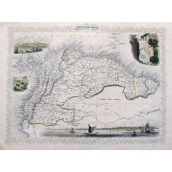
Venezuela, New Granada, Equador, and The Guayanas.
A highly decorative steel-engraved map from Panama to French Guayana. Very detailed with place names, rivers, hills, bays, etc. Attractively illustrated with vignette sty...
Place & Date: London, ca. 1850
Selling price: $60
Sold in 2018

Chili and La Plata.
A very decorative steel-engraved map extending from the border of Bolivia until Patagonia, with northern Chile and northern Argentina. Very detailed with place names, riv...
Place & Date: London, ca. 1850
Selling price: $65
Sold in 2017
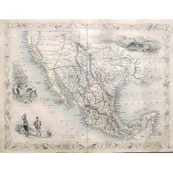
Mexico, California and Texas.
An excellent and important map that shows the Californian gold-rush of the 1840s. After gold was discovered in California, the plate was re-engraved to include a vignett...
Place & Date: London, ca. 1850
Selling price: $150
Sold in 2017

British America.
A very decorative steel-engraved map of Canada, highly detailed with place names, rivers, mountains, islands, bays, etc. Attractively illustrated with vignette style vie...
Place & Date: London, ca. 1850
Selling price: $25
Sold in 2017
![Ansei kaisei fugo on Edo ezu. [Tokyo]](/uploads/cache/40776-250x250.jpg)
Ansei kaisei fugo on Edo ezu. [Tokyo]
An extraordinary color-printed town-plan now-a-day Tokyo, and a fine example of Edo cartography. The present map is exceptionally detailed with accurate delineations of d...
Place & Date: Edo, ca. 1850
Selling price: $500
Sold in 2017

Europe.
While the map itself is quite simple without a great deal of detail, the surrounding engravings make this one of the most decorative 19th century maps. The map is framed ...
Place & Date: Paris, 1850
Selling price: $80
Sold in 2023
![[Plan of Edo / Tokyo.]](/uploads/cache/41893-250x250.jpg)
[Plan of Edo / Tokyo.]
A fascinating and impressive town plan of Edo/Yedo in Japan, during the Tokugawa Shogunate of the 1850s. After 1868, Yedo was renamed Tokyo.The publisher Owariya produced...
Place & Date: Tokyo, ca. 1850
Selling price: $125
Sold in 2020
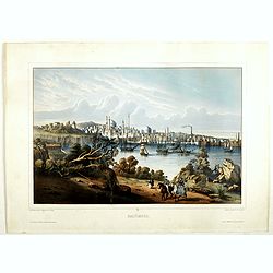
Baltimore.
Beautiful lithography of Baltimore after a design by Louis Le Breton (1818 Douarnenez - 1866 Paris). He drew this charming view as one of a series showing major ports of ...
Place & Date: Paris, Auguste Bry, ca. 1850
Selling price: $2000
Sold in 2018
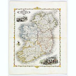
Ireland.
A delightful small map of the island of Ireland, by Alfred Adlard, published in his Vignette Modern School Atlas of the World. When looking at this map you are immediatel...
Place & Date: London, 1850
Selling price: $85
Sold in 2018
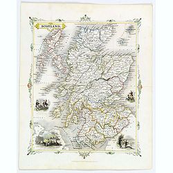
Scotland.
A delightful small map of Scotland, by Alfred Adlard, published in his Vignette Modern School Atlas of the World. When looking at this map you are immediately struck by i...
Place & Date: London, 1850
Selling price: $85
Sold in 2018

Amerique Septentrionale.
A beautiful map of the United States with Texas as a Republic, and extending into present day Canada, Russia in control of Alaska, and Mexico's northern border defined ac...
Place & Date: Paris, ca 1850
Selling price: $95
Sold in 2018
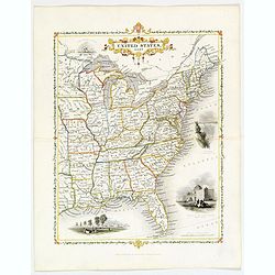
United States, East..
A delightful small map of the eastern portion of the United States, by Alfred Adlard, published in his Vignette Modern School Atlas of the World. When looking at this map...
Place & Date: London, 1850
Selling price: $65
Sold in 2020
Carte du Nouveau Continent & Carte de l'Ancien Continent.
Two maps with unusual projection. Published by Buffon after de Vaugondy.
Place & Date: Paris, ca 1850
Selling price: $20
Sold in 2018
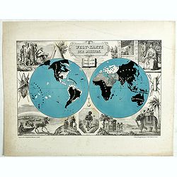
Welt-Karte der Mission.
A rare, double-hemisphere world map showing the Christian missions through out the world. Christian countries are left blank, non-Christian countries in darkness and blac...
Place & Date: Mullhausenl, ca 1850
Selling price: $300
Sold in 2019
Constantinople and the Bosphorus.
A detailed map of Istanbul and the Bosphorus. With many place names, and two insets: One of the Mosque of St. Sophia; and one of the Princess islands. By Findlay in Londo...
Place & Date: London, 1850
Selling price: $50
Sold in 2018

Amérique Septentrionale.
An important French map of North America, showing Texas within Mexico. The population table lists Texas with 200.000 and the United States with 19.000.000 inhabitants. Th...
Place & Date: Paris, ca 1850
Selling price: $62
Sold in 2018
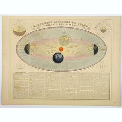
Mouvemens Apparens du Soleil, Theorie des Saisons.
A nice and attractive example of Andriveau-Goujon's decorative chart depicting the theory of the seasons as the earth orbits the Sun in an elliptical fashion, with 4 smal...
Place & Date: Paris 1850
Selling price: $55
Sold in 2020
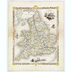
England and Wales.
A delightful small map of England and Wales, by Alfred Adlard, published in his Vignette Modern School Atlas of the World. When looking at this map you are immediately st...
Place & Date: London, 1850
Selling price: $40
Sold in 2020
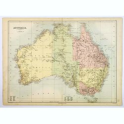
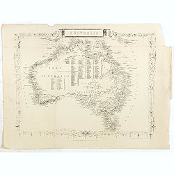
Australia.
A large, colored map of the continent of Australia, featuring 'Counties in Western Australia' 1-26 & 'Counties in South Australia 1-36'. As you would expect, nearly a...
Place & Date: Edinburgh, ca 1850
Selling price: $40
Sold in 2019
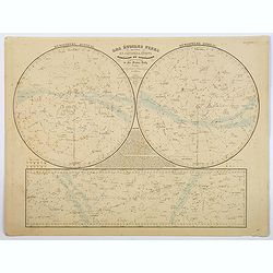
Les Etoiles Fixes divisees en Constallations Boreales et Australes. . .
A highly detailed double hemisphere chart of the northern and southern skies, showing the various constellations, as catalogued by Sir Francis Baily, along with a third c...
Place & Date: Paris, 1850
Selling price: $55
Sold in 2019
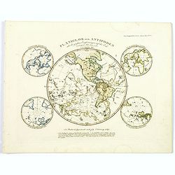
Planiglob der Antipoden...
Interesting projection of the world: The two hemispheres shown mirrored into one hemisphere, illustrating points opposite to one other on the globe. Further with four sma...
Place & Date: Gotha, 1850
Selling price: $45
Sold in 2020

Valletta and its Environs.
A bird's-eye view of Valletta. Surrounded by views of important places in town, and two of local costume. The Brocktorffs were a family of artists who had an important li...
Place & Date: Valetta, 1850
Selling price: $750
Sold in 2020

Amerique Septentrionale.
A beautiful map of the United States with Texas as a Republic, and extending into present day Canada, Russia is in control of Alaska, and Mexico's northern border defined...
Place & Date: Paris, ca 1850
Selling price: $85
Sold in 2020

Colonies Françaises (en Amérique.)
A very decorative 19th-century map showing the French Colonies in the Americas, the islands of St Martin, St Pierre et Miquelon and Terra Nova. Includes also Guyana. The ...
Place & Date: Paris, 1850
Selling price: $16
Sold in 2021
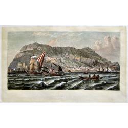
GIBRALTAR.
This print is one from a series of thirty-two published in a volume entitled 'The Route of the Overland Mail To India'. The print is by the artist Henry Fitzcook, a paint...
Place & Date: London, 1850
Selling price: $70
Sold in 2019
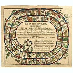
Jeu de l'Oie, renouvelé des Grecs, Jeu de plaisir et de récréation.
French Jeu de l'Oie (Game of the Goose) game board on thin paper with 63 numbered pictorial compartments, in the center, the rules of the game and the 63rd compartment, i...
Place & Date: Epinal, ca. 1850
Selling price: $35
Sold in 2019

Sizhou city, Jiangsu Province.
An original Qing Dynasty era Chinese manuscript map of Sizhou city in Jiangsu province, China.Sizhou was destroyed by floods during emperor Kangxi reign about 300 years a...
Place & Date: China, ca. 1850
Selling price: $950
Sold in 2019
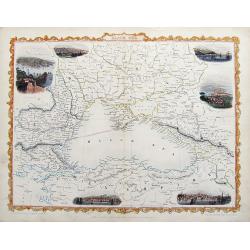
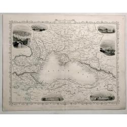
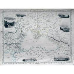
Black Sea.
A fine steel engraved map of the Black Sea and surrounding areas. With small decorative views of Sevastopol, Varna, Odessa, Sinope, Constantinople, and Silistria, all nic...
Place & Date: London, ca 1850
Selling price: $35
Sold in 2019
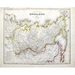
Asiatisches Russland 1850.
A highly detailed map of Russia with parts of China and Japan. Filled with topographical information. From Meyers Grosser Zeitungs-Atlas, the most important German Atlas ...
Place & Date: Hildburghausen, 1850
Selling price: $10
Sold in 2019
![[Set of 6 tinted lithographic views of St. Petersburg.]](/uploads/cache/44570-250x250.jpg)
[Set of 6 tinted lithographic views of St. Petersburg.]
A set of 6 delightful views of St. Petersburg, with titles in both Russian and French. Published in Paris by Daziaro. Lithographed by Jacottet & Regamey. Image 1. Adm...
Place & Date: Paris, ca 1850
Selling price: $220
Sold in 2020
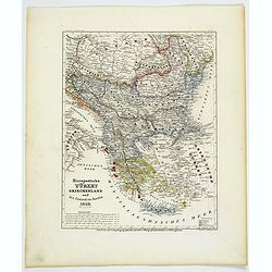
Europaeische Turkey, Griechenland und die Ionischen Inseln.
A steel-engraved outline hand color map Turkey in Europe, color-coded by region, with an explanation box lower right corner. An interesting historical map showing the reg...
Place & Date: Hildburghausen, 1850
Selling price: $17
Sold in 2021
Austria.
A striking hand-colored lithographed map of Austria by Montegue. It features inserted vignettes of the city of Vienna, the Fortress of Komorn and Croatian Irregular Troop...
Place & Date: London, ca 1850
Selling price: $32
Sold in 2019
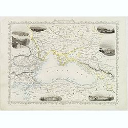
Black Sea.
Detailed and decorative map of The Black Sea with six vignettes of Sebastopol, Varna, Odessa, Sinope and Constantinople.. A John Tallis map published by The London Prin...
Place & Date: London, 1850
Selling price: $75
Sold in 2019
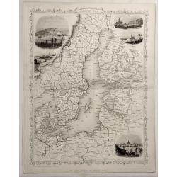
Baltic Sea.
Detailed and decorative map of The Baltic Sea with five vignettes of Kronstadt, Revel, St. Petersburg, Abo and Helsingfors. A John Tallis map published by The London P...
Place & Date: London, 1850
Selling price: $75
Sold in 2019
Black Sea.
Decorative steel engraved map of the Black Sea with inset views of Sebastopol and Odessa. There are also vignettes of Constantinople, Sinope and Varna. Taken from "T...
Place & Date: London, London Printing and publishing Company of London, ca. 1851
Selling price: $75
Sold in 2019
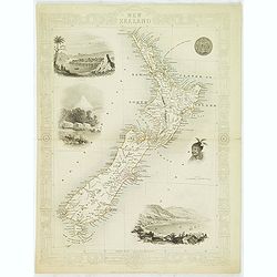
New Zealand.
Decorative steel engraved map of New Zealand, surrounded by illustrations of Auckland, Mount Egmont, a New Zealander, and the port of Wellington. Border in a New Zealand ...
Place & Date: London, 1851
Selling price: $350
Sold in 2023

Western Hemisphere.
Decorative steel engraved map of Western Hemisphere, surrounded 12 decorative vignettes. Taken from "The illustrated atlas and modern history of the world by John Ta...
Place & Date: London, 1851
Selling price: $150
Sold in 2012
The World on Mercators Projection Shewing the Voyages of Captain Cook Round the World.
Full color example of this beautiful World map with a distinctive decorative border, a vignette of Captain Cook’s ship the 'Endeavour' and Captain Cook’s tracks. Base...
Place & Date: London, 1851
Selling price: $200
Sold in 2015
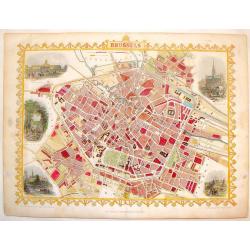
Brussels.
Striking hand-colored town plan of Tallis's "Brussels". It features vignettes of hotel de Ville, Palace royal, avenue in the Park, View from Port Anderlecht and...
Place & Date: London, 1851
Selling price: $99
Sold in 2014
Black Sea.
Great steel engraved map of the Black Sea and surrounding areas. With small decorative views of Sevastopol, Varna, Odessa, Sinope, Constantinople, and Silistria! A decor...
Place & Date: London, c1851
Selling price: $36
Sold in 2013
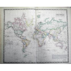
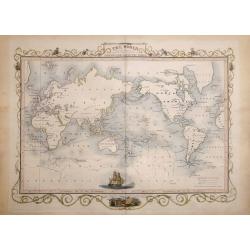
The World on Mercators Projection.
Large map of the world filled with interesting features: ~The seas are filled with explorers tracks ~Partial coasts of Antarctica shown with dates of discovery ~...
Place & Date: Liverpool, 1851
Selling price: $53
Sold in 2013

Birds' eye view of New Orleans. . .
A panoramic view of New-Orleans drawn from nature on stone by J.Bachman. Bird's-eye view of The Big Easy spread out along the banks of the Mississippi, upon which steambo...
Place & Date: New York, 1851
Selling price: $5800
Sold in 2015

Chile, La Plata or the Argentine Republic and Bolivia.
A fine example of Adam and Charles Black's 1851 map of Chile, the Argentine Republic and part of Bolivia. The map illustrates Bolivia's claims to the Atacama Desert and a...
Place & Date: Edinburgh, 1851
Selling price: $60
Sold in 2013

A Distant View of the Falls of Niagara.
A fine colored print of Niagara Falls accented by a Rococco trellis and five miniature engravings.
Place & Date: Edinburgh, 1851
Selling price: $99
Sold in 2015
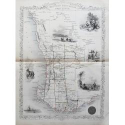
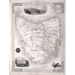
Western Australia, Swan River.
Decorative steel engraved map of part of Western Australia and Swan River extending from Champion Bay to Doubtful Island Bay. With decorative illustrations of Perth, Abor...
Place & Date: London, ca. 1851
Selling price: $75
Sold in 2014
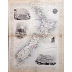
New Zealand.
An interesting and detailed map of the islands, with vignettes of Auckland, Mount Egmont from New Plymouth, Wellington and others.John Tallis was one of the last great de...
Place & Date: London, 1851
Selling price: $250
Sold in 2017

Probable Effects of Over Female Emigration.
Hand-colored satirical etching by illustrator & cartoonist, George Cruikshank and issued in his "THE COMIC ALMANAC" for 1851. On the left of this panoramic ...
Place & Date: London, 1851
Selling price: $135
Sold in 2016
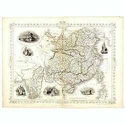
China and Birmah.
A highly decorative and detailed map of China and Burma which was drawn and engraved by J. Rapkin (vignettes by A. H. Wray & J. B. Allen).Showing British Factories in...
Place & Date: London & New York: John Tallis & co, c.1851
Selling price: $200
Sold in 2017
Mappemonde en deux Hemisphères.
Double hemisphere world map centered on Australia and New Zealand. Prepared by J. Andriveau-Goujon and included in his "Atlas Universel". Prime meridian to Pari...
Place & Date: Paris, 1851
Selling price: $47
Sold in 2015
Australia.
Steel engraved map of Australia, taken from a geographical series, not the same as a Tallis atlas map. The map is more frequently seen with surrounded illustrations of Sy...
Place & Date: London, the london printing and publishing company, ca. 1851
Selling price: $100
Sold in 2020
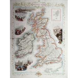
The British Isles.
A highly decorative and detailed mid-19th century map of the British Isles, which was drawn and engraved by J. Rapkin with the vignettes by John Salmon & Robert Walli...
Place & Date: London, 1851
Selling price: $130
Sold in 2016
Van Diemen's Island or Tasmania.
A very decorative steel-engraved map of the island, highly detailed with place names, rivers, hills, bays, etc.Attractively illustrated with vignette style views of Hobar...
Place & Date: London, 1851
Selling price: $95
Sold in 2016
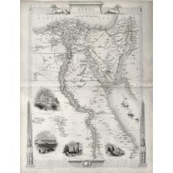
'EGYPT AND ARABIA PETRAEA'
A highly decorative and detailed mid-19th century map of Egypt with large vignettes of the Mosque of the Sultan Hassan, Alexandria, Ruins of the Great Temple Karnac, Grea...
Place & Date: London 1851
Selling price: $80
Sold in 2016

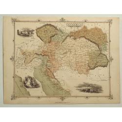
Austrian Dominions
A fine map of the Austrian empire, covering the territories claimed by the once vast Austrian empire, including in whole or part the modern day nations of Austria, Hungar...
Place & Date: London, 1851
Selling price: $15
Sold in 2016

The Illustrated Atlas and Modern History of the World.
This scarce and very desirable folio atlas is one of the last "decorative type" atlases to be published. Sometimes called the "Tallis Atlas", this com...
Place & Date: London, New York, 1851
Selling price: $3950
Sold in 2016
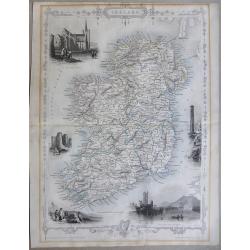
Ireland
A highly detailed and decorative map of Ireland with Illustrations of St Patricks Dublin, Limerick castle, Round Tower Wicklow, The Holy well, and Ross Castle Lake Killar...
Place & Date: London, 1851
Selling price: $100
Sold in 2019

Polynesia or Islands in the Pacific Ocean.
Decorative and attractive map of the Islands in the Pacific Ocean.
Place & Date: London ,1851
Selling price: $75
Sold in 2016
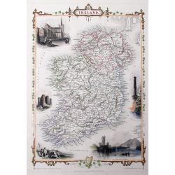
Ireland
A very decorative steel-engraved map of the island, highly detailed with place names, railroads, rivers, hills, bays, etc.Attractively illustrated with vignette style vie...
Place & Date: London, 1851
Selling price: $107
Sold in 2016

Switzerland.
A very decorative steel-engraved map of Switzerland. Very detailed with numerous place names, mountains, rivers, hills, lakes, etc. Locates the Mount Blanc, Lake Como, an...
Place & Date: London, 1851
Selling price: $10
Sold in 2016

East Canada and New Brunswick.
This is John Tallis’ map of East Canada, or what is now Quebec and New Brunswick. Includes Montreal, Quebec City, and the St. Lawrence River valley. Features five vigne...
Place & Date: London, 1851
Selling price: $55
Sold in 2016

British America.
A decorative and useful map of modern day Canada, when it was still under British rule in the mid nineteenth century. Provinces are outlined in red, with additional annot...
Place & Date: London, 1851
Selling price: $170
Sold in 2016

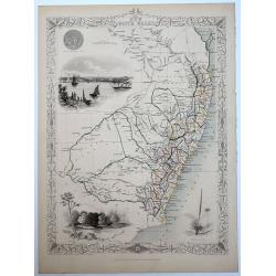
South America.
This is John Tallis’ pretty map of South America. The map is surrounded by a number of topical steel engraved vignettes and the whole is surrounded by a decorative vine...
Place & Date: London, 1851
Selling price: $25
Sold in 2016

West Canada.
This is John Tallis’ attractive map of West Canada. The map is surrounded by a number of topical steel engraved vignettes, including Niagara Falls, Kingston, Indians, B...
Place & Date: London, 1851
Selling price: $55
Sold in 2016

China and Birmah.
A highly decorative and detailed map of China and Burma drawn and engraved by J. Rapkin.Drawn by A.H. Wray and J.B. Allen, the map's vignettes include British factories i...
Place & Date: London & New York, c. 1851
Selling price: $130
Sold in 2018

Northern India.
Decorative steel engraved map of Northern India, surrounded 6 decorative vignettes.Taken from "The illustrated atlas and modern history of the world by John Tallis&q...
Place & Date: London, 1851
Selling price: $50
Sold in 2018

Cabool, the Punjab and Beloochistan.
Decorative steel engraved map of Cabool, the Punjab and Beloochistan, surrounded 3 large, decorative vignettes.Taken from "The illustrated atlas and modern history o...
Place & Date: London, 1851
Selling price: $85
Sold in 2017
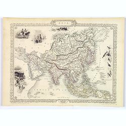
Asia.
The lovely map of Asia by John Tallis, characterised by its decorative border, and numerous delicate vignettes surrounding the map itself. West from Turkey in Asia across...
Place & Date: London, 1851
Selling price: $158
Sold in 2017

Polynesia or Islands in the Pacific Ocean.
A decorative and attractive map of the Islands in the Pacific Ocean. The map extent shows parts of California, Papua New Guinea, eastern Australia, and southern Japan.The...
Place & Date: London ,1851
Selling price: $71
Sold in 2017

Turkey in Europe.
A decorative steel engraved map of Albania, Macedonia, Rumania, Bulgaria, Moldavia and the European part of Turkey with insets of the Bosporus and Constantinople and depi...
Place & Date: London, ca. 1851
Selling price: $38
Sold in 2019
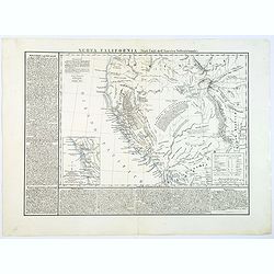
Nuova California (Stati Uniti de l'America Settentrionale).
This scarce Italian map of the western USA, which is based on Hypolite Ferry's map of 1850, has additional extensive notes on the history and resources of the region.A su...
Place & Date: Naples, 1851
Selling price: $350
Sold in 2018

Amerique Meridionale.
A decorative map of South America showing political divisions in color. The map is surrounded by steel engraved scenes including horses, Indians, jaguars, tapirs, mining ...
Place & Date: Paris, 1851
Selling price: $30
Sold in 2018

'Allied-Powers, Un-Booting Egalité.'
Napoléon Bonaparte. The allies Russia, Austria, Turkey and Britain remove a boot, representing Italy, from Napoleon's leg. A James Gillray engraving, first published in ...
Place & Date: London, 1851
Selling price: $120
Sold in 2017
New South Wales.
A decorative steel engraved map of the Australian state of N.S.W., surrounded by steel engraved vignette illustrations. Further enhanced with a decorative border design.J...
Place & Date: London, ca. 1851
Selling price: $100
Sold in 2018
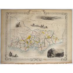
Victoria or Port Phillip.
A decorative steel engraved map of the Australian state of Victoria, surrounded by steel engraved vignette illustrations. Further enhanced with a decorative border design...
Place & Date: London, ca. 1851
Selling price: $80
Sold in 2018

Ionian Islands and Greece.
This is John Tallis’ pretty map of the Ionian Islands and Greece. The map is surrounded by a five delicate steel engraved vignettes, and the whole is surrounded by a de...
Place & Date: London, 1851
Selling price: $20
Sold in 2018