Browse Listings

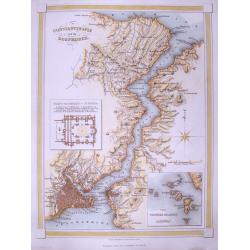
Cercanias de Baracoa ?
From Album pintoresco de la isla de Cuba - La Havane.
Place & Date: Hamburg and Berlin, c.1850
Selling price: $150
Sold in 2009

El Zapateado ?
From Album pintoresco de la isla de Cuba - La Havane.
Place & Date: Hamburg and Berlin, c.1850
Selling price: $105
Sold in 2009
![[Milan and environs]](/uploads/cache/25394-250x250.jpg)
[Milan and environs]
Extremely rare large folding hand colored lithographed town-plan of Milan and its environs on 9 sheets, 11 of which each dissected into 12 sections of 14cm. sq. the centr...
Place & Date: Milan, ca. 1850
Selling price: $2000
Sold in 2016

Afrique. Physique et division. Etudes 33 et 35.
Map of Africa. With an empty central Africa " Pays entievement inconnu aux Européens".
Place & Date: Paris, c.1850
Selling price: $80
Sold in 2010
Independent Tartary.
A charming map of Tartary published in London, 1851. The last of the decorative maps.
Place & Date: London, 1850
Selling price: $90
Sold in 2010
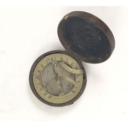
Pocket brass sundial with magnetic compass and hardwood case.
The top of the sundial is hinged and a curved scale is used to set your local latitude angle. The magnetic compass permits the sundial to be oriented North. The local tim...
Place & Date: London, ca. 1850
Selling price: $1450
Sold in 2010

Marchand et marchande Russes.
Lithography presenting Russian traders.
Place & Date: Paris, c. 1850
Selling price: $55
Sold in 2019
Mexico, California and Texas.
Excellent and important map to show the goldrush in California. After gold was discovered in California, the plate was re-engraved to include a vignette of gold washing a...
Place & Date: London, c1850
Selling price: $240
Sold in 2010
France Comparative en Provinces et en Departements . . .
Map of France
Place & Date: France, c.1850
Selling price: $1
Sold in 2010

Madagascar marchais Malais.
Steel engraving depicting a typical market scene on Madagascar. From "Extrait de voyage autour du monde et naufrages celebres".
Place & Date: Paris, c.1850
Selling price: $25
Sold in 2016
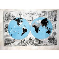
![[Set of World and 5 continents - 7 maps ].](/uploads/cache/44957-250x250.jpg)
[Set of World and 5 continents - 7 maps ].
One of the last decorative maps of the 19th century. In side panels representations of the four seasons, figures, local scenes. World map, Europe, Asia, North America, Af...
Place & Date: Paris, 1850
Selling price: $600
Sold in 2024
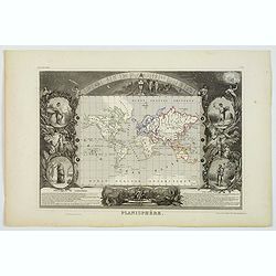
Planisphere.
One of the last decorative maps of the area. In side panels representations of the four seasons. In original o.l. color, from his "Atlas Universel Illustré". T...
Place & Date: Paris, 1850
Selling price: $75
Sold in 2020

Perth, in West-Australien, vom Berge Eliza aus.
A very decorative steel engraving of the city with buildings, and sailing ships. Drawn by A. H. Payne, engraved by W. French. Published only 20 years after foundation. Ta...
Place & Date: Leipzig, ca. 1850
Selling price: $13
Sold in 2020
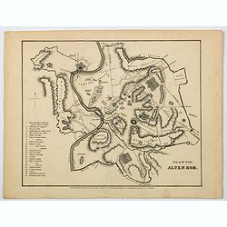
Plan vom Alten Rom.
A nice German plan of the ancient walled city of Rome, published in the mid 19th century. Down the lower left side of the plan is a numbered key (1-25) to main buildings ...
Place & Date: Hildburghausen, ca 1850
Selling price: $27
Sold in 2021
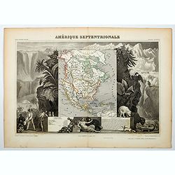
Amerique Septentrionale.
A beautiful map of the United States with Texas as a Republic, and extending into present day Canada, Greenland and the Arctic are shown, Russia is in control of Alaska, ...
Place & Date: Paris, ca 1850
Selling price: $100
Sold in 2020
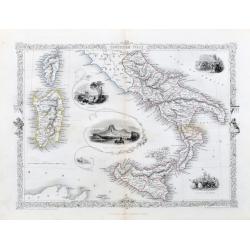
Southern Italy.
A very nice steel engraving from the atlas by R. Montgomery. The map shows southern Italy from Piombino to Sicily. Including Corsica and Sardinia. With beautiful vignette...
Place & Date: London, Edingburgh & Dublin, ca. 1850
Selling price: $52
Sold in 2020

Fragments d'un voyage autour du monde.
Rare album illustrated with a lithographed composition on the title showing the Sacred Ark of the Hindus, repeated on the first cover of the cardboard and 12 tinted litho...
Place & Date: Moulins, Desrosiers, no date but 1850
Selling price: $1300
Sold in 2021

Das Chinesische Reich und die Japanischen Jnseln.
A fine steel-engraved map from a scarce German Atlas: 'Schuberth's Hand-Atlas'. It shows China, Korea and Japan, as well as surrounding areas including Mongolia, Siberia,...
Place & Date: Nuremberg, ca 1850
Selling price: $17
Sold in 2021

Karte von dem Südöstlichen Theile Australia's zur Übersicht der Entdeckungen im Innern von Neu Süd Wales bis zum Jahre 1832.
A fine map of South East Australia including Adelaide, Melbourne, Brisbane, and Sydney. With very interesting details of the interior, including short descriptions and no...
Place & Date: Gotha, ca 1850
Selling price: $19
Sold in 2021
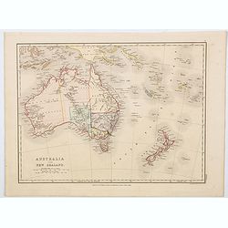
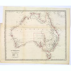
Australia and New Zealand.
A lovely map of Australia and New Zealand rendered in original soft pastel colours, published by E.P. Williams in London & Eton College. It is to be supposed that thi...
Place & Date: London, ca 1850
Selling price: $65
Sold in 2023
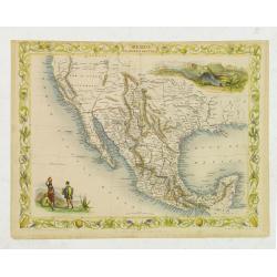
Mexico California and Texas.
John Tallis and John Rapkin's highly desirable map of Mexico, Texas, and Upper California. The “Great Caravan Route” used by covered wagons during the westward expans...
Place & Date: London, Edinburgh, Dublin, c.1850
Selling price: $190
Sold in 2012
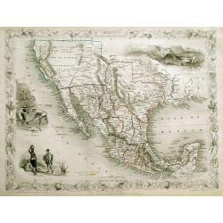
Mexico, California and Texas.
Excellent and important map to show the goldrush in California. After gold was discovered in California, the plate was re-engraved to include a vignette of gold washing a...
Place & Date: London, c1850
Selling price: $325
Sold in 2013
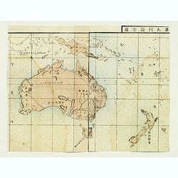
Australia and New Zealand.
Japanese map of Australia and New Zealand from a geography book.
Place & Date: Japan, ca. 1850
Selling price: $40
Sold in 2012
![[Untitled map of the European countries in a playing grid].](/uploads/cache/32644-250x250.jpg)
[Untitled map of the European countries in a playing grid].
Small, accurate lithographed map of Europe, embedded in a square playing grid formed by 100 cells.The map presumably represents the extension of the territories under Rom...
Place & Date: France, ca. 1850
Selling price: $75
Sold in 2014
![[Untitled map of the European countries in a playing grid].](/uploads/cache/32645-250x250.jpg)
[Untitled map of the European countries in a playing grid].
Small, accurate lithographed maps of Europe and Asia, embedded in a square playing grid formed by 100 cells.The 11 cells contain the profile of or a reference to a empero...
Place & Date: France, ca. 1850
Selling price: $75
Sold in 2015
![[ Montelbaanstoren in Amsterdam ]](/uploads/cache/92206-250x250.jpg)
[ Montelbaanstoren in Amsterdam ]
Interesting view of the Montelbaanstoren in Amsterdam. Highly detailed print with buildings, people, the watergate, and ships.
Place & Date: c1850
Selling price: $25
Sold in 2012

EAST CANADA AND NEW BRUNSWICK.
Detailed map of the area from Montreal to New Brunswick. Highly decorative map with an inset view of Quebec, a scene of North American Indians, and the ornamental borders...
Place & Date: London, c1850
Selling price: $70
Sold in 2013
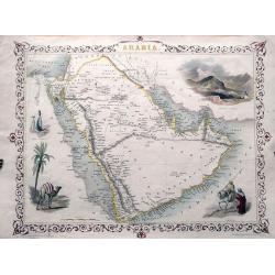
ARABIA.
Detailed map of the Arabian Peninsula. With numerous place names, and several routes through the desert. Highly decorative map with an inset view of Mount Sinai, scenes...
Place & Date: London, c1850
Selling price: $95
Sold in 2013
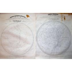
Pair of 2 maps: CARTE CELESTE... & CARTE CELESTE MUETTE. . .
Very rare pair of large celestial charts, illustrating several hundreds of stars. Indicating the sizes of the stars, and names also constellations. Diameters of the globe...
Place & Date: Geneva, 1850
Selling price: $200
Sold in 2013
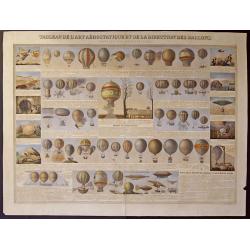
Tableau de l´art Aerostatique et de la direction des Ballons.
Beautiful representation of different balloons and the art of flying.
Place & Date: Paris, 1850
Selling price: $350
Sold in 2014

Carte de la côte nord de Java (de la pointe d'Intramayoe au détroit de Sourabaya). . .
Great large-scale sea-chart of a part of northern Java and the Java Sea. Shows the area from Indramayu to Surabaya, including Karimunjawa and Bawean. With numerous depth ...
Place & Date: Paris, 1850
Selling price: $62
Sold in 2014

Overland Route to India.
Steel engraved map of the Overland Route to India. The illustrations are by H Warren and engraved by J H Kernot, the map engraved by J Rapkin. Published by John Tallis. T...
Place & Date: London, 1850
Selling price: $80
Sold in 2014

Dutch landscape with cows and windmill.
Attractive lithography showing a typical Dutch landscape with cows and windmill, lithographed by C.W. Mieling after a painting by H. van de Sande Bakhuijsen. Published in...
Place & Date: The Hague, 1850
Selling price: $35
Sold in 2018
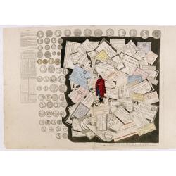
Tableau des Papiers et Monnoyes.. (tompe-l'oeil)
A tompe-l'oeil showing different French bank notes, coins, land grants and shares. Decorative.
Place & Date: Paris, 1850
Selling price: $200
Sold in 2016
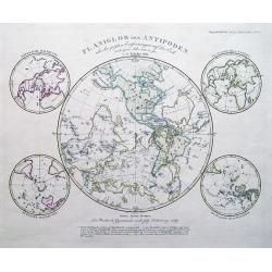
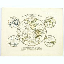
PLANIGLOB der ANTIPODEN...
Interesting projection of the world: The two hemispheres shown mirrored into one hemisphere, illustrating points opposite to one other on the globe. Further with four sma...
Place & Date: Gotha, 1850
Selling price: $50
Sold in 2014
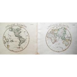
(2 maps) Westliche Halbkugel & Oestliche Halbkugel.
A pair of maps showing the two Hemispheres. With interesting details: suggesting an open North-West-Passage, partial Antarctica coast lines, and many regions and importan...
Place & Date: Gotha, 1850
Selling price: $48
Sold in 2014
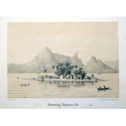
Dronning Pomares Oe.
Rare lithographed plate of an island in French Polynesia with huts, people, and boats. After a drawing by Christian Thornam.
Place & Date: Copenhagen, ca. 1850
Selling price: $50
Sold in 2015

Champlain's Map of New France 1632.
FROM 1850 NEW YORKSTATE HISTORY. - A nineteenth century lithograph reproduction of a seminal map.
Place & Date: (1632) 1850
Selling price: $160
Sold in 2014

Champlain's Map of New France 1632.
FROM 1850 NEW YORKSTATE HISTORY. A nineteenth century lithograph reproduction of a seminal map.
Place & Date: New York, 1850
Selling price: $100
Sold in 2015
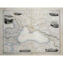
Black Sea.
A detailed and highly decorative map of the area around the Black sea. The map is enhanced by vignette illustrations of Sebastopol, Varna, Odessa, Sinope, Silistra, and ...
Place & Date: London, 1850
Selling price: $60
Sold in 2018
Constantinople and the Bosphorus.
A detailed map of Istanbul and the Bosphorus. With many place names, and two insets: One of the Mosque of St. Sophia; and one of the Princess islands.
Place & Date: London, c1850
Selling price: $36
Sold in 2014
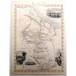
British Guayana.
Pleasing map of British Guyana with four fine lithographed vignettes of scenes from Guyana. It was drawn and engraved by J. Rapkin and published in London by John Tallis ...
Place & Date: London, 1850
Selling price: $27
Sold in 2016

Boydell's Shakespeare - Merchant of Venice.
Fine hand-colored engraving from Boydell's Shakespeare Gallery, published in about 1850 in London. Engraved by J. Parker from a painting by R. Wesfall featuring a scene f...
Place & Date: London, c1850
Selling price: $17
Sold in 2019
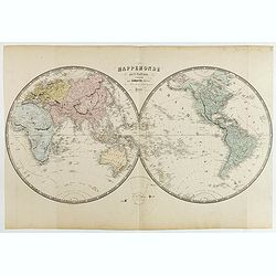
Mappemonde en deux Hemisphères.
Double hemisphere world map centered on Australia and New Zealand. Prepared by A. Vuillemin and published by Combette, 15 rue de la Parcheminerie, Paris. Printed by Lemer...
Place & Date: Paris, Combette, ca 1850
Selling price: $36
Sold in 2015
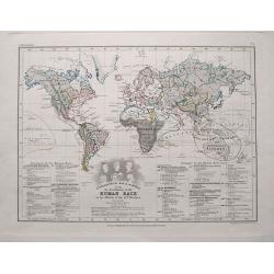
Ethnographical map of the World showing the distribution of the Human race in the middle of the 19th century...
Great thematical map, showing numerous nations and their distribution around the world. Interesting to see many indian peoples controlling large parts of world, many of w...
Place & Date: London, c1850
Selling price: $54
Sold in 2015
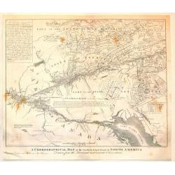
A Chorographical Map of the Northern department of North America.
A detailed map of the United States and Canada showing Lake Ontario and the St. Lawrence River at the bottom with New Hampshire at the top. This is a smaller edition of a...
Place & Date: New Haven, 1850
Selling price: $114
Sold in 2015
![[World Map]](/uploads/cache/95857-250x250.jpg)
[World Map]
Engraved by E.Neureuther, from "Historia Naturalis Palmarum opus tripartitum", by Carl Friedrich Philipp von Martius, Leipzig, 1823–50. 3 vols. in one.Modern ...
Place & Date: Leipzig, 1823-1850
Selling price: $1300
Sold in 2015
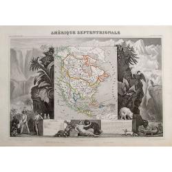
Amérique Septentrionale.
Important French map of North America, showing Texas as an independent republic. The population table lists Texas with 200.000 and the United States with 19.000.000 inha...
Place & Date: Paris, ca. 1850
Selling price: $100
Sold in 2018

Gerard Dow von ihm selbst gemalt.
Lithograph; overall size 67 x 49 cm by Franz Hanfstaengl, after an original self portrait by Gerard Dow (Dou); printed on papier de Chine, pasted onto thicker paper; wi...
Place & Date: Munich, c1850
Selling price: $46
Sold in 2015
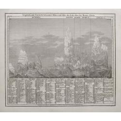
Vergleichende Übersicht bekannter Höhen und Orte der Erde über der Meeres-Fläche.
An interesting illustration of the comparative height of mountains around the world. Identifies around 400 mountains divided by continent. Dhaulagiri, in the Nepali Himal...
Place & Date: Hildburghausen, ca. 1850
Selling price: $46
Sold in 2015
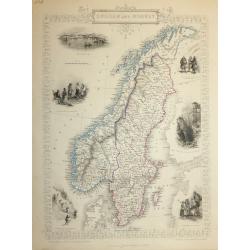
SWEDEN AND NORWAY
A highly detailed and decorative map of Norway and Sweden issued by John Tallis. Published in London, Edinburgh and Dublin circa 1850.The map has an elaborate border, and...
Place & Date: London, 1850
Selling price: $60
Sold in 2016

A Chorographical Map of the Northern Department of North America.
A Chonographical Map of the Northern Department of North America.A detailed map that shows the Townships or Land Grants found in portions of New Hampshire, Vermont, and N...
Place & Date: New Haven, 1850
Selling price: $100
Sold in 2017
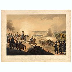
Die Schlacht Von Novara.
Showing the Battle of Novara or Battle of Bicocca (Bicocca is a borough of Novara) which was one of the battles fought between the Austrian Empire and the Kingdom of Sard...
Place & Date: Vienna, 1850
Selling price: $25
Sold in 2016

Five Indo / Persian miniature paintings, Mogul Dynasty.
Five Indo/Persian miniature paintings, Mogul Dynasty miniature painting in delicate Opaque watercolors on paper, with Islamic scripts on recto and verso. Each miniature a...
Place & Date: Northern Indian Mogul dynasty, ca 1850
Selling price: $750
Sold in 2016

Der Warme Meeresstrom des Atlantischen und der Kalte Strom des Grossen Oceans...
Unusual thematic map of the ocean currents around the Americas. Lists the temperatures of the Gulf Stream and the Equatorial current's.
Place & Date: Gota, ca. 1850
Selling price: $27
Sold in 2016

Karte vom Grossen Ocean...
Interesting map of the Pacific Ocean, showing a wealth of currents, routes and dates of explorations , temperatures, etc.
Place & Date: Hildburghausen, ca. 1850
Selling price: $17
Sold in 2016

West India Islands.
Beautiful map of the Caribbean - from Florida to Venezuela. Decorated with the embellished borders, a view of Kingston in Jamaica, sailing ships, and a native couple. Exc...
Place & Date: London, ca. 1850
Selling price: $33
Sold in 2016
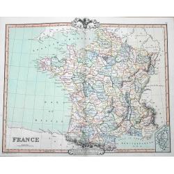
France
A fine map of France by George Frederick Cruchley. It covers all of France, seen here divided in its various departments. An inset shows the French island of Corsica. Ele...
Place & Date: London, 1850
Selling price: $12
Sold in 2016

Canada
A large and highly detailed map of the area between Lake Huron and the Gulf of the Saint Lawrence River, complete with references to the Townships, notes about Indians, a...
Place & Date: Edinburgh, ca 1850
Selling price: $40
Sold in 2016

Puschkin.
Steel engraved half-length portrait of Alexander Sergeyevich Pushkin, a Russian poet, playwright, and novelist of the Romantic era who is considered by many to be the gre...
Place & Date: Germany, 1850
Selling price: $10
Sold in 2018
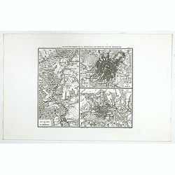
Plan des bords de la Berezina, de Moscou et de Smolensk.
Prepared by Thunot Duvotenay (1796-1875), a French geographer and publisher. Detailed map taken from: "Thiers, Atlas de l' Histoire du Consulat et de l' Empire"...
Place & Date: Paris, 1850
Selling price: $25
Sold in 2016
Kronstadt, in der ferne Petersburg.
View of Kiev. Original steel engraving, published by Bibliographisches Institut Hildburghausen.
Place & Date: Hildburghausen, 1850
Selling price: $20
Sold in 2019
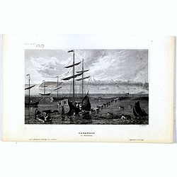
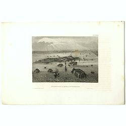
Taganrog in Russland
View of Tarangow. Original steel engraving, published by Bibliographisches Institut Hildburghausen. Engraved by E.Willmann.
Place & Date: Hildburghausen, 1850
Selling price: $10
Sold in 2021
Planiglob der Antipoden...
Interesting projection of the world.
Place & Date: Gotha, 1850
Selling price: $15
Sold in 2016
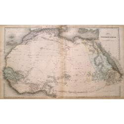
Northern Africa.
Large and detailed map Northern Africa. Shows several routes through the Sahara desert including place names and oasis. However large parts are left blank. An excellent u...
Place & Date: London, ca. 1850
Selling price: $25
Sold in 2016

South America.
A detailed map of South America from the famous Atlas by John Tallis. With many place names, regions, and countries shown.Highly decorative map with ornamental borders, s...
Place & Date: London, ca 1850
Selling price: $80
Sold in 2017
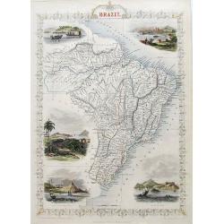
Brazil
A very decorative steel-engraved map of Brazil, highly detailed with place names, rivers, hills, bays, etc. Attractively illustrated with vignette style views of "Bo...
Place & Date: London, ca 1850
Selling price: $58
Sold in 2017

Turkey in Europe.
A very decorative steel-engraved map of South-East Europe, extending from Dalmatia until the Black Sea. Very detailed with place names, rivers, hills, bays, etc. With a s...
Place & Date: London, ca. 1850
Selling price: $15
Sold in 2017
Falkland Islands and Patagonia.
Two very decorative steel-engraved maps on one sheet. Both maps are very detailed with place names, rivers, hills, islands, bays, etc.Attractively illustrated with vignet...
Place & Date: London, ca.1850
Selling price: $40
Sold in 2017

Peru & Bolivia
A very decorative steel-engraved map extending from Guayaquil southwards until the Atacama. Very detailed with place names, rivers, hills, bays, etc.Attractively illustra...
Place & Date: London, ca.1850
Selling price: $75
Sold in 2017
Northern Italy.
A very decorative steel-engraved map with many place names, rivers, hills, bays, islands, lakes, etc. Attractively illustrated with vignette style views of "The Gran...
Place & Date: London, ca.1850
Selling price: $47
Sold in 2017
Northern India
A very decorative steel-engraved map of a portion of India including Nepal, Bhutan, and modern day Bangladesh. Very detailed with place names, rivers, hills, bays, lakes,...
Place & Date: London, ca.1850
Selling price: $75
Sold in 2017
Asie.
Charming map of the continent, surrounded by animals and people dressed in their traditional clothing. Columns on the sides contain text and numbers of population of the ...
Place & Date: Paris, ca. 1850
Selling price: $70
Sold in 2020

Asie.
A fine detailed map of Asia by Louis Antoine, published in Paris in about 1850.
Place & Date: Paris, ca. 1850
Selling price: $61
Sold in 2017
Australia in 1846.
In original outline color, a map of the continent of Australia in 1846, from the S.D.U.K. publication. The map identifies the years and names of the explorers who discove...
Place & Date: London, ca. 1850
Selling price: $45
Sold in 2017
Welt-Karte der Mission.
A rare, double-hemisphere world map showing the Christian missions throughout the world. Christian countries are left blank, non-Christian countries in darkness and black...
Place & Date: Basel, ca 1850
Selling price: $210
Sold in 2019
A Map of the Land of Matrimony.
A delightful, fun manuscript map of A Map of the Land of Matrimony, drawn by an amateur, during the mid nineteenth century. The map itself is pasted onto a large, ornatel...
Place & Date: England, ca. 1850
Selling price: $135
Sold in 2017
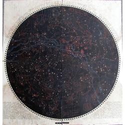
Der Nördliche Gestirnte Himmel Dargestellt von Dr. Frdn. Reuter.
Extremely rare celestial chart of the northern sky. Printed on four sheets. Stars are shown at five different magnitudes as explained in the legend. The stars of the grea...
Place & Date: Gotha, ca. 1850
Selling price: $800
Sold in 2017

Map of America.
A large map of the Americas, and the Western hemisphere, including New Zealand, Polynesia, Greenland etc. Each country colored in outline color. Major cities, waterways a...
Place & Date: London ca.1850
Selling price: $110
Sold in 2018

Australien (Oceanien)
Striking German map of Australia and Polynesia with three inserts including Van Diemens Land, West Australia and New South Wales. The map maker is unknown and the map is...
Place & Date: Germany, c. 1850
Selling price: $75
Sold in 2017