Browse Listings
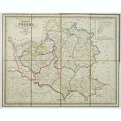
Mapa Polski za panowania Stanislawa Augusta w roku 1772.
Map of the Polish reign of Stanislaw August Poniatowski in 1772. The text is in Polish and the map is showing the cities of Cracovie, Braclaw, Minsk, etc.Published by S. ...
Place & Date: Warsaw, 1849
Selling price: $300
Sold in 2014
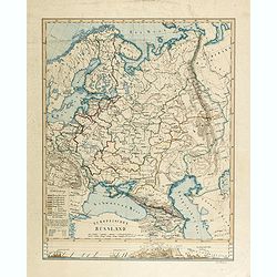
Europaïsches Russland (Manuscript map)
Map of Russia, including Finland, Poland, Sweden and Norway and the Aral Sea in the east. Signed lower right "Carl Hoeckner" and most likely drawn by Carl Hoeck...
Place & Date: Hildburghausen, ca. 1849
Selling price: $700
Sold in 2014
![[Bird's-Eye View of Petra] and [Ground Plan of Petra]](/uploads/cache/93803-250x250.jpg)
[Bird's-Eye View of Petra] and [Ground Plan of Petra]
Pair of steel engravings from "Forty days in the desert on the track of the Israelites, or, A journey from Cairo by Wady Feiran to Mount Sinai and Petra", in th...
Place & Date: London, 1849
Selling price: $15
Sold in 2014

As It Ought To Be or The Ladies Trying a Contemptible Scoundrel for a . . .
Hand-colored satirical etching by illustrator & cartoonist, George Cruikshank and issued in his "THE COMIC ALMANAC" for 1849.A large lady sues for "Bre...
Place & Date: London, 1849
Selling price: $101
Sold in 2017

Three Early Government Survey Maps of Indiana.
Three of the earliest obtainable government survey maps of Indiana. 1) No. 1, R,” Index to Recorded Field Notes, Indiana”. Maker: General Land Office. Washington, 184...
Place & Date: Washington, 1845-1849
Selling price: $15
Sold in 2019
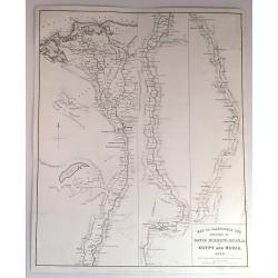
Map to Illustrate the Sketches of David Roberts, Esq. in Egypt and Nubia, 1849.
An original lithograph for the subscription edition of David Robert's “Egypt and Nubia”, published by F.G. Moon & Son, London, 1846-49.Tripartite map of the Nile ...
Place & Date: London, 1849
Selling price: $75
Sold in 2017

Uppdráttr Íslands / Carte d'Islande.
This rare and highly engaging map represents the first integrated (single-sheet) edition of Iceland's first accurate topographical map. Long considered among the most �...
Place & Date: Copenhagen, 1849
Selling price: $1675
Sold in 2016
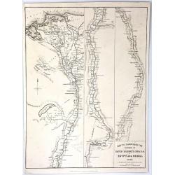
Map to Illustrate the Sketches of David Roberts, Esq: R.A. in Egypt and Nubia
An original lithograph map for the subscription edition of David Robert's “Egypt and Nubia”, published in London by F.G. Moon & Son in 1846. It is a tripartite ma...
Place & Date: London, 1849
Selling price: $51
Sold in 2016
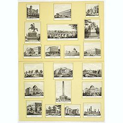
20 small lithographed views of Washington DC and Georgetown.
20 small lithographed town-views of Washington DC and Georgetown, cut out from a larger sheet. Showing the East Front of the Capitol, Treasury, Smithsonian Institute, Pre...
Place & Date: Casimir Bohn, Washington, D.C.: 1849

China, Pescadores Islands..
Very detailed chart of the Pescadores Islands, who are located west of Taiwan. Chart published by the Hydrographic Office of the Admiralty in London. Sold by J. Potter, L...
Place & Date: London 1849
Selling price: $200
Sold

Arrivée d'une famille en Californie.
Four pages of Le Charivari a satiric magazine for which Cham prepared and lithographed many illustration.Humoristic view of an arrival of a family in California. Ah! mon ...
Place & Date: Paris 1849
Selling price: $80
Sold
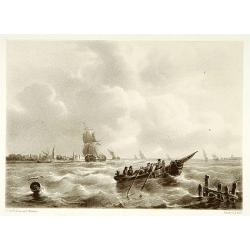
Shipping.
Attractive lithography showing Dutch vessels off the Dutch coast, by C.C.A. Last after a painting by C.C.Kannemans. Published in "Kunst Kroniek".
Place & Date: The Hague 1849
Selling price: $50
Sold in 2014

Atlas Geografico de la Tierra, coleccion de mapas. . .
Rare Spanish pocket atlas containing 2 celestial maps, double hemisphere world map, 18 classical maps, Europe (2), Mediterranean, Spain, France, England (2), Scotland, Ir...
Place & Date: Madrid, 1849
Selling price: $1150
Sold in 2015

Dai Nihon Eitai Setsuyo Mujinzo.
Interesting Japanese encyclopaedia, starting with a world map, a map of Japan (with figured borders), 4 bid's eye maps of Japan, views of Mt. Fuji and its surrounding are...
Place & Date: Japan, Kaei 2 = 1849
Selling price: $375
Sold
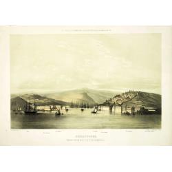
Sebastopol algemeen gezigt op de stad, de havens en de forten.
Attractive and rare lithography showing Dutch vessels off the Dutch coast, by C.C.A. Last after a painting by C.C.Kannemans. Beautiful and very rare lithography of the po...
Place & Date: The Hague, P. Blommers, c. 1849
Selling price: $275
Sold in 2011

Missien van den Oregon en Reizen naer de rotsbergen en de bronnen de Colombia, der Athabasca en Sascatshawin in 1845-46. Title maps: Nieuwe Kaert des grondgebieds van den Oregon, Bronnen der Columbia;; Bronnen der Rivier Tète-Plate.
12mo, (2), vii, 423 p, hlf. leath. (new). With lithograph title, frontisp. portrait, 15 plates and 3 uncolored folding maps: 20.5 x 27.2 cm, 13 x 20 cm (2x).The Dutch edi...
Place & Date: Gent, 1849
Selling price: $700
Sold
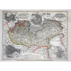
Österreich: Lombardisch-Venetianisches Königreich
A superbly steel-engraved map from the rare German Atlas: Meyer's Zeitungs-Atlas, considered to be the finest German Atlas of the mid 19th century!Showing the area of the...
Place & Date: Hildburghausen, 1849
Selling price: $30
Sold
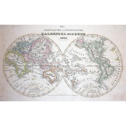
Die Oestliche und Westliche Halbkugel der Erde
A superbly steel-engraved map from the rare German Atlas: Meyer's Zeitungs-Atlas, considered to be the finest German Atlas of the mid 19th century!In original hand-colori...
Place & Date: Hildburghausen, 1849
Selling price: $30
Sold
Mapa general de las islas Philipinas Ano de 1849.
Provenance : Ex libris del Marqués de Pidal. Mapa Filipinas. 1847. N° 20. In lower left bottom a label : Junta delegada de incautacion proteccion y Salvamento del tesor...
Place & Date: Spain, c. 1849
Selling price: $13100
Sold in 2011

Verkenningen Genomen in de Wijnkoops-Baai.
A large so-called Blue-back chart of a part of Java, dated 1849, shows the results of local surveys in 1835-1849. No publisher mentioned (probably the Dutch Geographical ...
Place & Date: Jakarta, 1849
Selling price: $400
Sold in 2008

Map to Illustrate the Route of David Roberts, Esq: R.A. in The Holy Land, Petrea, & Syria
A fine large format map from Roberts' The Holy Land, Syria, Idumea, Arabia, Egypt & Nubia.A map of Egypt, the Sinai, and the Holy Land, detailing the journey undertak...
Place & Date: London, 1849
Selling price: $50
Sold in 2016
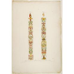
Pilastri eseguiti a colori nella Sala de Pranzi del Reale..
Decorative print of columns in a Palace in Venice. The design is by G.Borsato and presented are the signs of Ram and Twins..
Place & Date: Italy c.1850
Selling price: $30
Sold

ZURICH prise depuis la Weid Coté du Nord.
Very decorative bird's-eye view of Zürich, engraved by Hurlimann and published by H.F.Leuthold. After a design by Burri.
Place & Date: Zürich c.1850
Selling price: $100
Sold

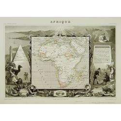
Afrique.
A very decorative 19th century map showing Africa. The map is surrounded by portraits, animals, vegetation, etc.. Includes also three views of Alexandria, Cairo and Alger...
Place & Date: Paris 1850
Selling price: $160
Sold
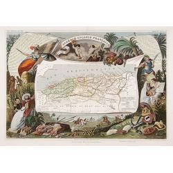
Algerie Colonie Française.
A very decorative 19th century map of Algeria. The map is surrounded by horses, products of the country, natives, etc.
Place & Date: Paris 1850
Selling price: $170
Sold
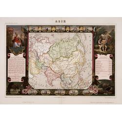
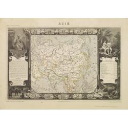
Asia.
A very decorative 19th century map of Asia. The map is surrounded by vignettes, portraits, animals, vegetation, etc.
Place & Date: Paris 1850
Selling price: $200
Sold
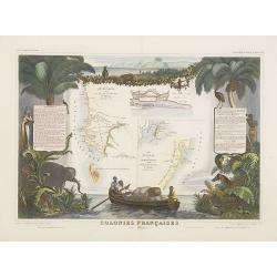
Colonies Françaises (en Afrique).
A very decorative 19th century map of western coast of Africa and includes a map of the coast of Madagascar. The map is surrounded by portraits, animals, vegetation, etc....
Place & Date: Paris, 1850
Selling price: $100
Sold in 2018
Afrique.
A decorative 19th century map of the continent colored to show the colonial possessions and major tribal kingdoms. The interior is mostly void of detail. The map is surro...
Place & Date: Paris 1850
Selling price: $120
Sold

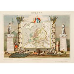
Europe.
While the map itself is quite simple without a great deal of detail, the surrounding engravings make this one of the most decorative 19th century maps. The map is framed ...
Place & Date: Paris 1850
Selling price: $100
Sold
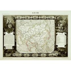
Asie
A decorative 19th century map of the continent. The map is surrounded by steel engraved vignettes depicting costumes of the various peoples of Asia, Adam and Eve, and sev...
Place & Date: Paris 1850
Selling price: $100
Sold
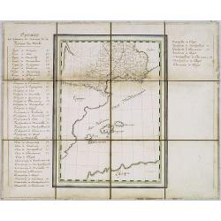
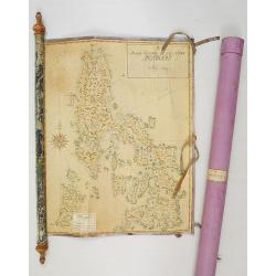
Manuscript map of the Southern Provinces of France.
Very detailed manuscript folding-map of the southern part of France. Including Lyon, Nice, Marseilles, Toulouse.Including the Balearic Islands of Majorca, Minorca, Ibiza....
Place & Date: France ca. 1850
Selling price: $475
Sold in 2020

Charte von Paraguay entworfen von Dr. J.R.Rengger.
Detailed map of Paraguay. Lithographed by father and son Engelmann.
Place & Date: Mulhouse 1850
Selling price: $60
Sold
![[Untitled map of the Mediterranean countries in a playing grid].](/uploads/cache/23365-250x250.jpg)
[Untitled map of the Mediterranean countries in a playing grid].
Small, accurate map centered on the Mediterranean Basin with the adjacent countries, embedded in a square playing grid formed by 100 cells.The map presumably represents t...
Place & Date: France, ca. 1850
Selling price: $50
Sold in 2009
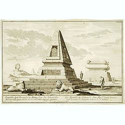
Les Pyramides du tombeau de Sotis?
Imaginary view.
Place & Date: France c.1850
Selling price: $40
Sold

Nieu Amsterdam, een stedeken in Noord Amerikaes,..
Lithographed view of New York, seen from the harbour. Text in English underneath. Copied after P.Schenk.Important view of New York City which celebrates the Dutch recap-t...
Place & Date: London 1850
Selling price: $150
Sold

Valletta and its environs.
In center a bird's-eye view of Valletta. Surrounded by 1 views of important places in town, and 2 costume plates.RARE.
Place & Date: England, ca 1850
Selling price: $1450
Sold
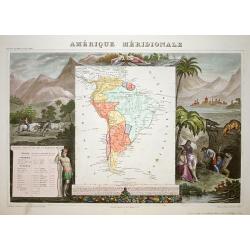
Amerique Meridionale.
A very decorative 19th century map of the continent colored to show political divisions. The map is surrounded by fully colored, steel engraved scenes including horses, I...
Place & Date: Paris 1850
Selling price: $95
Sold
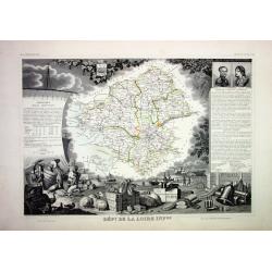
Lot of 4 French Departements
Four very decorative engraved maps of the French Departements: Haut Rhin, Loire, Lozère, Doubs. Ornately decorated borders, vignette scenes, portraits and views of the r...
Place & Date: Paris, 1850
Selling price: $50
Sold

Europe
Very decorative steel-engraved map of Europe. Ornately decorated with medallion portraits of the heads of European Countries and their respective heraldic arms, Scales o...
Place & Date: Paris, 1850
Selling price: $50
Sold

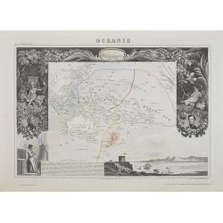
Océanie
Very decorative steel-engraved map of Australia and the Pacific. Ornately decorated with Indians, plants, portraits, harbor view and descriptive text.
Place & Date: Paris, 1850
Selling price: $50
Sold
Asie.
A decorative 19th century map of the continent. The map is surrounded by steel engraved vignettes depicting costumes of the various peoples of Asia, Adam and Eve, and sev...
Place & Date: Paris 1850
Selling price: $90
Sold
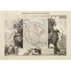
Amérique Septentrionale.
A very decorative map with the United States extending into present day Canada, Russia in control of Alaska and Mexico's northern border according to the Treaty of 1810. ...
Place & Date: Paris 1850
Selling price: $200
Sold

Europe.
A very decorative 19th century map showing Europe. The map is surrounded by portraits and coat of arms of European countries, cherubs, vegetation, etc.A very popular and ...
Place & Date: Paris 1850
Selling price: $100
Sold
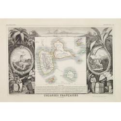
Colonies Françaises. (en Amérique)
A decorative 19th century map of the colony islands Guadeloupe, Grande Terre and Marie Galante, which is surrounded by beautifully engraved vignettes and tropical plants ...
Place & Date: Paris 1850
Selling price: $70
Sold
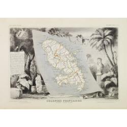
Colonies Françaises. Martinique - Amérique du Sud.
A very decorative 19th century map of the Martinique Island. The map is surrounded by the products of the island like tobacco, sugar, etc. A decoration of trees and birds...
Place & Date: Paris 1850
Selling price: $90
Sold

Colonies Françaises (en Amérique.)
A very decorative 19th century map showing the islands of St Martin, St Pierre et Miquelon and Terra Nova. Includes also Guyana. The map is surrounded by portraits, anima...
Place & Date: Paris 1850
Selling price: $100
Sold

PARIS. Vue prise au dessus du Rond-Point des Champs-Elysées.
From Voyage aerien en France, L'Italie à vol d'oiseau. Made by Jules Arnout and printed by Lemercier. Published by A.Hauser. Bd. des Italiens.The publication is extrem...
Place & Date: Paris, c.1850
Selling price: $400
Sold

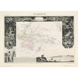
Océanie.
An attractive map from one of the last decorative atlases of the nineteenth century. The map covers the entire South Pacific including Australia and New Zealand and South...
Place & Date: Paris 1850
Selling price: $200
Sold

Die Staaten von Missouri, Illinois, Indiana, Ohio, Kentucky.
Detailed map of Missouri, Illinois, Indiana, Ohio, Kentucky and Tennessee with numerous physical and political features including mines, settlements, trails/roads, forts ...
Place & Date: Hildburghausen/ Philadelphia 1850
Selling price: $35
Sold
![Panda, Paradoxures, etc [4 prints]](/uploads/cache/13488-250x250.jpg)
Panda, Paradoxures, etc [4 prints]
Decorative copper engravings for Georges-Louis Leclerc, comte de BUFFON, this great naturalist (1707-88) spent the greater part of his life at his chateau de Montbard and...
Place & Date: France 1838-1850
Selling price: $15
Sold in 2011

Afrique
Classic Levasseur treatment; smaller map (8" x 9") embedded in very elaborate engraved scenes about the people, animals and plants of the subject region. Small ...
Place & Date: Paris, 1850
Selling price: $170
Sold
Europe.
A very decorative 19th century map showing Europe. The map is surrounded by portraits and coat of arms of European countries, cherubs, vegetation, etc..
Place & Date: Paris 1850
Selling price: $180
Sold

Amérique Septentrionale.
A nice map of the continent showing the national boundaries, but not the individual states and provinces.The United States is shown with its boundary with Canada complete...
Place & Date: Paris 1850
Selling price: $100
Sold

A view general of the City de Havana of Amerique. / Vue generale de ..
Very decorative and colorful panoramic view over Havana harbour. Engraved for a Vue d'Optique, it was designed to be viewed in a special apparatus that gave the scene a s...
Place & Date: Ca. 1850
Selling price: $100
Sold

OISEAUX. 1. L'Ara bleu - 2. L'Ara rouge.
Noteworthy bird print engraved by Massard after a drawing by Vauthier.
Place & Date: Paris ca. 1850
Selling price: $120
Sold in 2011

OISEAUX. 1. Le Lori rouge - 2. La Perruche à collier rose. - 3. La grande Perruche à longs trins.
Noteworthy bird print engraved by Lecerf after a drawing by Vauthier.
Place & Date: Paris, ca.1850
Selling price: $100
Sold in 2011

OISEAUX. 1. Le Lori noira - 2. Le Lori cramoisi. - 3. Le Lori tricolor.
Noteworthy bird print engraved by Aubert after a drawing by Vauthier.
Place & Date: Paris, ca.1850
Selling price: $120
Sold in 2011

ASIATISCHER ARCHIPEL UND NEU HOLLAND 1849
Steel engraved map from "Meyers Zeitungs und Groschen-Atlas" by J. Meyer, considered on of the best German atlases in the 19th century.Very detailed representat...
Place & Date: Hildburghausen, c1850
Selling price: $50
Sold in 2008

Hottentot Vrouw.
Decorative, hand colored, woodcut engraving illustrating a woman from the South African Hottentots tribe.
Place & Date: Amsterdam, ca. 1850
Selling price: $30
Sold in 2011
![Opperhoofd der Vos Indiaanen. [Fox indians]](/uploads/cache/23391-250x250.jpg)
Opperhoofd der Vos Indiaanen. [Fox indians]
Decorative, hand colored, woodcut engraving illustrating the chief of the Fox Indian tribe.After a war with the Illinois (c.1765), the Fox moved into Illinois territory. ...
Place & Date: Amsterdam, ca. 1850
Selling price: $20
Sold in 2016

Hottentot.
Decorative, hand colored, woodcut engraving illustrating a warrior from the South African Hottentots tribe.
Place & Date: Amsterdam, ca. 1850
Selling price: $30
Sold in 2011

Groep van Raven-Indiaanen.
Decorative, original hand colored, woodcut engraving illustrating a group of Native Americans belonging to the Raven tribe.
Place & Date: Amsterdam, ca. 1850
Selling price: $20
Sold in 2016

Californien, Oregon Utah und Neu-Mejico.
An attractive lithographed map of western America with original coloring by Carl Flemming.Oregon is essentially the same as on the Mitchell map, above, but modern Califor...
Place & Date: Glogau ca 1850
Selling price: $300
Sold
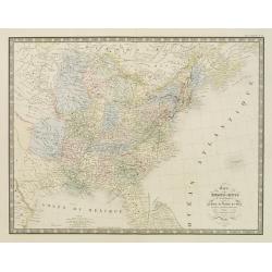
Carte des Etats-Unis d''''Amérique comprenant une Partie des Districts de l''''Ouest et de la Nouvelle Bretagne..
Map of the states east of the Mississippi and the adjacent Indian Territories to the west. Texas is shown as a separate state.Relief shown by hachures. From the Atlas cl...
Place & Date: Paris, 1850
Selling price: $150
Sold in 2020
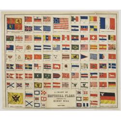
A Chart of National Flags. Published by Henry Bill. New York.
Lithograph by Thomas Sinclair, showing 105 flags, mostly national flags and a few merchant and pilot's flags.In the 1850s Italy was being created from several kingdoms, s...
Place & Date: Philadelphia, ca 1850
Selling price: $140
Sold

New Orleans
A beautifully rendered mid nineteenth century view of New Orleans, centered on the Mississippi River and the city's harbor. Many important sites are depicted as part of t...
Place & Date: New York, ca. 1850
Selling price: $90
Sold in 2008
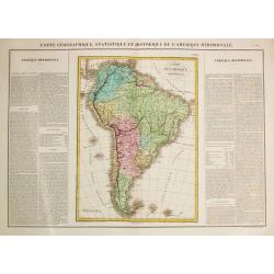
Carte Géographique, Statistique et Historique de l'Amerique Meridionale.
A fine, detailed map of South America with on both sides explanetary text.From "J.A. Buchon Atlas Gégraphique Statistique, historique et chronologique des deux Amé...
Place & Date: Paris, 1850
Selling price: $100
Sold in 2016

Afrique.
A decorative 19th century map of the continent colored to show the colonial possessions and major tribal kingdoms. The interior is mostly void of detail. The map is surro...
Place & Date: Paris, 1850
Selling price: $150
Sold in 2008

Koran Page
A page from a hand written Koran circa 1800's text surrounded by gold leaf box and marginal decorative drawing in upper corner.
Place & Date: Unknown, circa 1850
Selling price: $50
Sold in 2008

Koran Page
A page from a hand written Koran circa 1800's text surrounded by gold leaf box and marginal decorative drawing in upper corner.
Place & Date: Unknown circa 1850
Selling price: $50
Sold in 2008

Mexico, California and Texas.
Excellent and important map to show the goldrush in California. After gold was discovered in California, the plate was re-engraved to include a vignette of gold washing a...
Place & Date: London, c1850
Selling price: $365
Sold in 2008
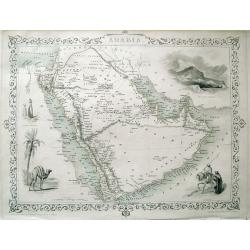
ARABIA.
Detailed map of the Arabian Peninsula, Persian Gulf, and the Red Sea. With numerous place names, and several routes through the desert shown. Highly decorative map with ...
Place & Date: London, c1850
Selling price: $100
Sold in 2013

Carte Generale du Perou de la Bolivie, du Chili, et la Plata.
Map of the western part of South America, from Atlas Universel De Geographie Physique, Politique, Ancienne Et Moderne …, published by Ch. Delagrave.
Place & Date: Paris, 1850
Selling price: $9
Sold in 2011
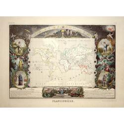
Planisphere.
Nice map from one of the last decorative atlases of the nineteenth century. The map is presented on Mercator''s projection and surrounded by fine steel engravings includi...
Place & Date: Paris, 1850
Selling price: $300
Sold in 2008
Carte militaire topographique et stratégique du Piemont.
Very detailed map of Piedmont, prepared by J.B.S. Raymond. Including the towns of Casal, Turin, Milan,
Place & Date: Paris, Villain, 1850
Selling price: $50
Sold in 2015
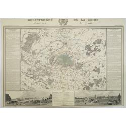
Departement de La Seine Environs de Paris.
A decorative 19th century map of the French department de La Seine with its capital Paris. The map is surrounded by two descriptive text panels to the left and right and ...
Place & Date: Paris, ca. 1850
Selling price: $300
Sold
Océanie.
A very decorative 19th century map of the Pacific Ocean, with hand colored lines indicating the extent of Polynesia, Mirconesia, Melanesia, and Malaysia (or Southeast Asi...
Place & Date: Paris, 1850
Selling price: $80
Sold in 2009

Afrique Septentrionale.
A uncommon map of northern part of Africa with nice detail to the different borders and depiction of the "Zahara ou Grand désert".
Place & Date: Paris, 1850
Selling price: $50
Sold in 2009
![[Edo period woodcut plan of Edo or Tokyo]](/uploads/cache/27903-250x250.jpg)
[Edo period woodcut plan of Edo or Tokyo]
Nice plan of Edo (present-day Tokyo) oriented with north to the right. Shows main temples and shrines pictorially. Includes distance chart and legend. In color, folded, l...
Place & Date: Japan c. 1850
Selling price: $550
Sold in 2009
Océanie.
A very decorative 19th-century map of the Pacific Ocean, with hand-colored lines indicating the extent of Polynesia, Micronesia, Melanesia, and Malaysia (or Southeast Asi...
Place & Date: Paris, 1850
Selling price: $95
Sold in 2022