Browse Listings
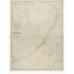
Chart to the coast of China from the Canton River to the Yang Tze Keang, prepared by John Walker, geographer to the Honble. East India Company.
Detailed chart to the coast of China, including Taiwan. The map has numerous insets (Hong Kong, River Woo-sung to Shanghai, Killon Harbour and Merope Bay Formosa, River M...
Place & Date: London 1847
Selling price: $1000
Sold
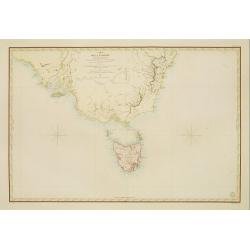
Carte de la Tasmanie et des terres environnantes..
Map of Tasmania, also giving good detail in the south eastern tip of the mainland. Showing Sydney, Botany Bay, etyc. Prepared by C.A. Vincendon-Dumoulin. Most information...
Place & Date: Paris 1847
Selling price: $550
Sold

Kaart van de vaarwaters en eilanden tusschen Sumatra en Borneo. . .
Very large and rare centered on the island of Bangka, showing the southeastern coast of Sumatra.With large title surmounted by 4 small inset maps showing details of the ...
Place & Date: Amsterdam, 1847
Selling price: $700
Sold
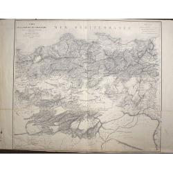
Carte de la Province de Constantine, dressée Au Dépôt Général de La Guerre sous la direction de M. le Lieutenant Général Pelet
Place & Date: Paris, 1847
Selling price: $165
Sold in 2008
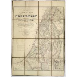
Carte Topographique de la Palestine dressée d'après la carte topographique levée par le savant Jacotin . . .
Uncommon folding map of the Holy Land published by Philip van der Maelen. Prepared by Jean van de Cotte after Jacotin and includes information gardened during expeditions...
Place & Date: Brussels, 1847
Selling price: $310
Sold in 2013
![[Title page] Les Fleurs.](/uploads/cache/31046-250x250.jpg)
[Title page] Les Fleurs.
Charming title page from volume 1 of J.J. Grandville's 'Les Fleurs Animées'. (The Flowers Personified)The book was a masterpiece of botanic illustration, the steel engra...
Place & Date: Paris, Dubuisson, 1847
Selling price: $50
Sold in 2020

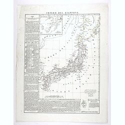
Impero del Giappone. Questa Carta e stata eseguita su quella pubblicata in Londra nel 1835, dalla Societa per la diffusione delle utili conoscenze, e su quella di Arrowsmith. . .
An interesting and uncommon detailed and large-scale Italian map of Japan published in Naples in Benedetto Marzolla's Atlante Geographico . Inset: Porto di Nangasaki (sca...
Place & Date: Naples, 1847
Selling price: $300
Sold in 2011
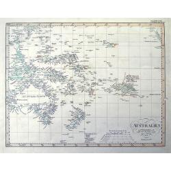
AUSTRALIEN nach Krusenstern...
A fantastic steel engraved map of Australia and the Pacific. Published in Stieler's Hand-Atlas.Dated 1826 but updated until 1847 with superb geography and exact details. ...
Place & Date: Gotha, 1847
Selling price: $46
Sold in 2011
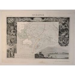
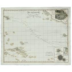
Oceanie, Description Historique Sur L'Ocean
A fine map of the southern Pacific Ocean, with decorative borders and views. Margin illustrations of excellent quality showing local peoples, explorers, products, landsca...
Place & Date: Paris, 1847
Selling price: $37
Sold in 2020
Impero del Giappone. . .
An interesting and uncommon detailed and large-scale Italian map of Japan published in Naples in Benedetto Marzolla's Atlante Geographico . Inset: Porto di Nangasaki (sca...
Place & Date: Naples, 1847
Selling price: $150
Sold in 2020
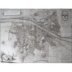
Pianta della Citta di Firenze.
Large decorative folding plan of Florence, copper engraved on thick paper. Folds between original "tree calf" paper covers, with manuscript title label to upper...
Place & Date: Florance, [ND] 1847
Selling price: $450
Sold in 2012

Carte générale de l'Océan Pacifique dressée Par Mr. C,A, Vincendon-Dumoulin 1845 Expédition au Pole Austral et dand l'Oéanie, commondée par M.Durmont d'Urville . . .
Four-sheet map of the Pacific Ocean showing good detail on Australia, New Zealand and the west coast of North and South America. In lower margin: Le plan grave´ par Jaco...
Place & Date: Paris, 1847
Selling price: $3600
Sold in 2013
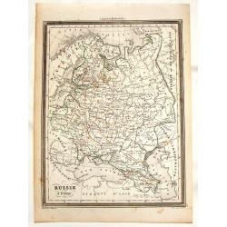
Russie d'Europe.
This striking engraved map of Russia comes from Vuillemin's "Universel de Geographie Ancienne et Moderne". The provinces or Oblests are outlined in red. The eng...
Place & Date: Paris, 1847
Selling price: $22
Sold in 2013
![[Untitled map of North West Russia with the White Sea].](/uploads/cache/34087-250x250.jpg)
[Untitled map of North West Russia with the White Sea].
Very detailed and rare map of North West Russia with the White Sea. The map has elaborate floral borders. Prepared by Joseph Scheda in Vienna.
Place & Date: Vienna, 1845-1847
Selling price: $100
Sold in 2013
![[Untitled map of central part Russia].](/uploads/cache/34088-250x250.jpg)
[Untitled map of central part Russia].
Very detailed and rare map of central part of Russia. The map has elaborate floral borders. Prepared by Joseph Scheda in Vienna.
Place & Date: Vienna, 1845-1847
Selling price: $100
Sold in 2013
![[Untitled map of the Ukraine].](/uploads/cache/34089-250x250.jpg)
[Untitled map of the Ukraine].
Very detailed and rare map of the Ukraine. Odessa in bottom and northern part of Lake Azow included. The map has elaborate floral borders. Prepared by Joseph Scheda in Vi...
Place & Date: Vienna, 1845-1847
Selling price: $150
Sold in 2013
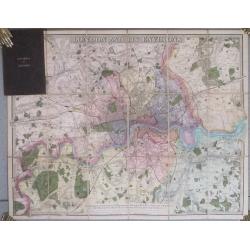
London And Its Environs. Containing the Boundaries of the Metropolitan Boroughs, the different Railroads & Stations, The New Cemetaries, Roads, Docks, Canals, and all modern improvements ...
The plan covers the extents from Tottenham down to Bromley and Barking across to Hanwell.The plan dissected into 18 sections and backed onto linen. Folds between dark bro...
Place & Date: London. 1847
Selling price: $250
Sold in 2014

(Map of Armenia and Iran)
Detailed map of Armenia, Iran, Iraq and part of Turkey in elaborate floral borders. Joseph Scheda in Vienna 1845 - 1847.
Place & Date: Vienna, 1845-1847
Selling price: $325
Sold in 2015
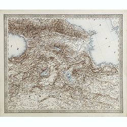
(Map of Armenia and Iran)
Detailed map of Armenia, Iran, Iraq and part of Turkey in elaborate floral borders. Published by Joseph Scheda in Vienna.
Place & Date: Vienna, 1845-1847
Selling price: $300
Sold in 2021
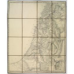
No title, a folding map of Palistine.
A rare proof state of Jacotin's map Carte Topographique de la Palestine. . All text on this issue is not filled in yet. The map has been updated by Jean van de Cotte and ...
Place & Date: Brussels, 1847
Selling price: $325
Sold in 2018
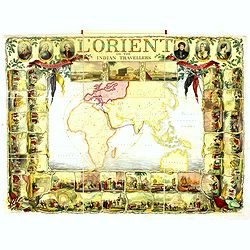
l'Orient or the Indian travellers. A geographical and historical game. . .
The game map shows the outward route from England to Calcutta via the Cape and back via Bombay and Aden. With a wide border of 36 historical scenes on 3 sides, and upper ...
Place & Date: London, c. 1847
Selling price: $3700
Sold in 2016

Der Preussische Staat
A fine detailed map of Prussia by Dr. F.W. Streit. Published in Leipzig in 1847. It was produced on two sheets that have been conjoined.
Place & Date: Leipzig, 1847
Selling price: $33
Sold in 2016
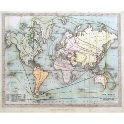
The World shewing the progress of discovery from the creation to the present time...
A curious map of the World published by the Society for promoting Christian Knowledge! Highly interesting map illustrating discoveries at different times. We could not tr...
Place & Date: London, 1847
Selling price: $51
Sold in 2016

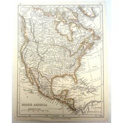
Amerique Septentrionale.
Beautiful map with the United States.
Place & Date: Paris, 1847
Selling price: $90
Sold in 2017
![Map No.5 United States [Alabama, Georgia, South Carolina, Florida].](/uploads/cache/39987-250x250.jpg)
Map No.5 United States [Alabama, Georgia, South Carolina, Florida].
A pleasant map of the S.E. corner of the United States, each state colored differently. A few lines of explanation beneath the plain title.Most major towns and cities dep...
Place & Date: New York, 1847
Selling price: $50
Sold in 2017
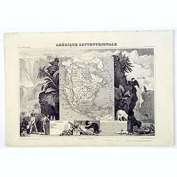
Amerique Septentrionale.
A beautiful map with the United States with Texas as a republic, and extending into present day Canada, Russia in control of Alaska, and Mexico's northern border defined ...
Place & Date: Paris, 1847
Selling price: $95
Sold in 2017

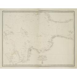
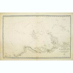
To Chas. Majoribanks esq.re and the other members of the hon.ble East India Company's factory at Canton, this Chart of Choo Keang or Canton river, is inscribed ... by James Horsburgh.
The chart stretches from north to south from Canton (Guangzhou) to Canzhou Island, and west to east from Dashi Bay to Hong Kong. Includes inset of Pearl River segment fro...
Place & Date: July 1831 corrections to 1847
Selling price: $6900
Sold in 2018
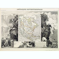
Amerique Septentrionale.
Beautiful map with the United States extending into present day Canada, Russia in control of Alaska and Mexico's northern border according to the Treaty of 1810. Surround...
Place & Date: Paris, 1847
Selling price: $120
Sold in 2019
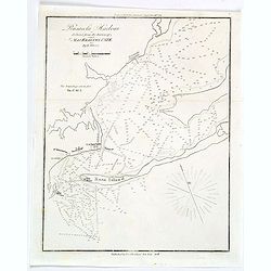
Pensacola Harbour.
A small naval chart of Pensacola Harbour and surrounds in Florida, reduced from a survey of Major Kearney, U.S.T.E. It features depth soundings (measured in feet), a Ligh...
Place & Date: New York, 1847
Selling price: $4
Sold in 2019
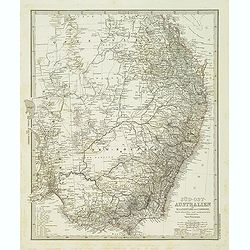
Süd-Ost-Australien. . .
Large and very detailed map of South East Australia.Published in Stieler's Hand Atlas.
Place & Date: Gotha, 1848
Selling price: $90
Sold in 2017
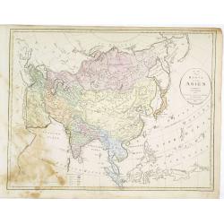
Karta öfver Asien.
An very rare map of Asia with Swedish text. This is an heavenly updated version of his map of 1817 and is now dated 1827, 1833.In lower part a color key to English, Frenc...
Place & Date: A. Wiborgs förlag, Stockholm, ca. 1848
Selling price: $170
Sold in 2016

Karta öfver Africa.
An very rare map of Africa with Swedish text. This is an heavenly updated version of his map of 1818 and is now dated 1828.In lower part a color key to Portuguese, Spanis...
Place & Date: A. Wiborgs förlag, Stockholm, ca. 1848
Selling price: $260
Sold in 2017
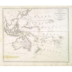
Karta öfver Australien eller Polynesien.
An very rare map of the continent of Australia, Southeast Asia and the Pacific Islands, with Swedish text. This is an heavenly updated version of his map of 1818 and is n...
Place & Date: A. Wiborgs förlag, Stockholm, ca. 1848
Selling price: $250
Sold in 2013
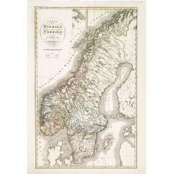
Karta öfver Sverige och Norrige.
An very rare and detailed map of Sweden and Norway with Swedish text. This is an heavenly updated version of P.B.Skölberg map of 1840 and engraved by C.Anderson in 1847....
Place & Date: A. Wiborgs förlag, Stockholm, ca. 1848
Selling price: $80
Sold in 2019
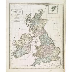
Karta öfver Stora Britannien eller England, Scotland och Irland.
An very rare map of Great Britain with Swedish text. This is an updated version of his map of 1819 and is now dated 1832.From his atlas "Geographisk Hand-Atlas"...
Place & Date: A. Wiborgs förlag, Stockholm, ca. 1848
Selling price: $100
Sold in 2013
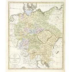
Karta öfver Tyskland.
An very rare map of Germany, Austria, and part of present-day Poland and Czech Republic with Swedish text. This is an updated version of his map of 1819 and is now dated ...
Place & Date: A. Wiborgs förlag, Stockholm, ca. 1848
Selling price: $38
Sold in 2022
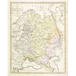
Karta öfver Ryssland.
An very rare map of European part of Russia, including Finland and Poland with Swedish text. This is an updated version of his map of 1821 and is now dated 1833.From his ...
Place & Date: A. Wiborgs förlag, Stockholm, ca. 1848
Selling price: $140
Sold in 2013
Karta öfver Österrike.
An very rare map of Austria, including present-day Hungary, Poland, Northern Italy, Trieste, the Dalmatian coast (with inset) with Swedish text. This is an updated versio...
Place & Date: A. Wiborgs förlag, Stockholm, ca. 1848
Selling price: $50
Sold in 2016

Karta öfver Helvetien.
An very rare map of Switzerland with Swedish text. This is an updated version of his map of 1820 and is now dated 1833.From his atlas "Geographisk Hand-Atlas" f...
Place & Date: A. Wiborgs förlag, Stockholm, ca. 1848
Selling price: $50
Sold in 2017
Karta öfver europeiska Turkiet och Mindre Asien.
An very rare map of Turkey with Greece and the Balkans still under Turkish occupation with Swedish text. This is an updated version of his map of 1821 and is now dated 18...
Place & Date: A. Wiborgs förlag, Stockholm, ca. 1848
Selling price: $195
Sold in 2015
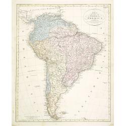
Karta öfver Södra America.
An very rare map of South America with Swedish text. The map is dated 1825. In upper right corner Suppl. 2.From his atlas "Geographisk Hand-Atlas" first publish...
Place & Date: A. Wiborgs förlag, Stockholm, ca. 1848
Selling price: $100
Sold in 2014

A chart exhibiting the normal course & velocity of the tidal current at ebb in Boston Harbor.
Interesting map of the currents in the Boston harbor.
Place & Date: Washington, 1848
Selling price: $6
Sold in 2013
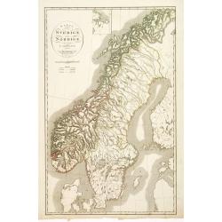
Karta öfver Sverige och Norrige.
An very rare and detailed map of Sweden and Norway with Swedish text. This is an heavenly updated version of P.B.Skölberg map of 1840 and engraved by C.Anderson in 1847....
Place & Date: A. Wiborgs förlag, Stockholm, ca. 1848
Selling price: $100
Sold in 2018
North America.
Published by Chapman and Hall from "Sharpe's Corresponding Maps".
Place & Date: London, 1848
Selling price: $35
Sold in 2019

Les Gens de Justice. - Oui, on veut dépouiler cet orphélin, que je ne qualifie pas de jeune. . .
Second state (of 2), with text. From "Les Gens de Justice". Text below image : - Oui, on veut dépouiler cet orphélin, que je ne qualifie pas de jeune, puis qu...
Place & Date: Paris, 1845-1848
Selling price: $1200
Sold

GEORGIEN. Costumes Persans 2.
A beautiful hand colored lithograph of a Georgian published in the French work "Galerie Royale de Costumes peints d´après nature par divers artistes et lithographi...
Place & Date: Paris, Chez Aubert & Cie., 1842-1848
Selling price: $225
Sold in 2015

PALICAR. (Iles de l'archipel grec). Costumes Syriens 8.
A beautiful hand colored lithograph of a Palicar published in the French work "Galerie Royale de Costumes peints d´après nature par divers artistes et lithographi�...
Place & Date: Paris, Chez Aubert & Cie., 1842-1848
Selling price: $250
Sold in 2017

JUIVE DE CONSTANTINOPLE. Costumes de l'Empire Ottoman 3.
A beautiful hand colored lithograph of an elegant Jewish woman from Constantinople published in the French work "Galerie Royale de Costumes peints d´après nature p...
Place & Date: Paris, Chez Aubert & Cie., 1842-1848
Selling price: $260
Sold in 2015

MARCHAND JUIF. A Constantinople. Costumes de l'Empire Ottoman 8.
A beautiful hand colored lithograph of a prominent Jewish merchant in Constantinople published in the French work "Galerie Royale de Costumes peints d´après nature...
Place & Date: Paris, Chez Aubert & Cie., 1842-1848
Selling price: $325
Sold in 2015

FEMME TURQUE. Costumes de l'Empire Ottoman 10.
A beautiful hand colored lithograph of Turkish woman published in the French work "Galerie Royale de Costumes peints d´après nature par divers artistes et lithogra...
Place & Date: Paris, Chez Aubert & Cie., 1842-1848
Selling price: $260
Sold in 2015

FEMME TURQUE VOILEE. Costumes de l'Empire Ottoman 6.
A beautiful hand colored lithograph of a Turkish veiled woman published in the French work "Galerie Royale de Costumes peints d´après nature par divers artistes et...
Place & Date: Paris, Chez Aubert & Cie., 1842-1848
Selling price: $205
Sold in 2015

FEMME de DAMAR. Costumes Syriens 5.
A beautiful hand colored lithograph of an elegant Syrian woman from Damar published in the French work "Galerie Royale de Costumes peints d´après nature par divers...
Place & Date: Paris, Chez Aubert & Cie., 1842-1848
Selling price: $350
Sold

CHALDEENE d'OURMYAHL. Costumes Persans 3.
A beautiful hand colored lithograph of a Chaldean woman from Ourmyahl published in the French work "Galerie Royale de Costumes peints d´après nature par divers art...
Place & Date: Paris, Chez Aubert & Cie., 1842-1848
Selling price: $300
Sold

GRECQUE de SMYRNE. Costumes de l'Empire Ottoman 2.
A beautiful hand colored lithograph of a Greek woman from Smyrn published in the French work "Galerie Royale de Costumes peints d´après nature par divers artistes ...
Place & Date: Paris, Chez Aubert & Cie., 1842-1848
Selling price: $200
Sold in 2015

KURDE de SOAUK-BOULAK. Costumes Persans 7.
A beautiful hand colored lithograph of a Kurd from Sauk Bolek published in the French work "Galerie Royale de Costumes peints d´après nature par divers artistes et...
Place & Date: Paris, Chez Aubert & Cie., 1842-1848
Selling price: $300
Sold

AFGAHN d'HERAT. Costumes Persans 8.
A beautiful hand colored lithograph of an Afghan from Herat published in the French work "Galerie Royale de Costumes peints d´après nature par divers artistes et l...
Place & Date: Paris, Chez Aubert & Cie., 1842-1848
Selling price: $250
Sold

MOLLAH ou PRETRE. Costumes Persans 4.
A beautiful hand colored lithograph of a Mollah published in the French work "Galerie Royale de Costumes peints d´après nature par divers artistes et lithographié...
Place & Date: Paris, Chez Aubert & Cie., 1842-1848
Selling price: $250
Sold

Impero di Marocco
Very attractive and scarce map of Morocco by Benedetto Marzolla, a cartographer from Naples. Marzolla prints extensive notes with his maps, listing his cartographic sourc...
Place & Date: Naples, 1848
Selling price: $109
Sold in 2017

Carta Generale dell'Antartica.
Benedetto Marzolla, was among the most relevant of the Italian cartographers of the XIX century, he used very high quality lithographies for his maps. His 'Atlante Geogra...
Place & Date: Naples, 1848
Selling price: $350
Sold in 2017
Ost-Polynesien Entwurf von Berghaus, Mai 1848.
An unusual 1854 Adolf Stieler map of eastern Polynesia, showing part of the Hawaiian Islands in the upper left corner. In the lower left corner is Tahiti and Nuka Hiwa. I...
Place & Date: Gotha, 1848
Selling price: $14
Sold in 2019

Dites donc, confrère, vous allez soutenir aujourd'hui contre moi absolument ce que je plaidais il y a trois semaines, dans une cause identique... hé hé hé!.. c'est drôle!..
Second state (of 2), with text, numbered 14. From "Les Gens de Justice", published " Chez Auber & Cie, Pl. de la Bourse,29". Translated text below...
Place & Date: Paris, 1848
Selling price: $27
Sold in 2023
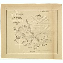
A chart exhibiting the normal course & velocity of the tidal current at ebb in Boston Harbor.
Interesting map of the currents in the Boston harbour. With many of the islands, among them: Thompson I., Spectacle I., Long I., Deer I., Lovells I., Peddocks I., Nahant ...
Place & Date: Washington, 1848
Selling price: $25
Sold in 2020
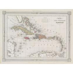
Antilles ou Indes Occidentales..
Detailed map of Caribbean, including tip of Florida, prepared by Th.Duvotenay. With good detail on Cuba, Porto Rico and Hispaniol.Engraved by Ch.Smith, published by Basse...
Place & Date: Paris 1848
Selling price: $80
Sold

Mécique..
Detailed map of Mexico and California, prepared by Th.Duvotenay.Engraved by Ch.Smith, published by Basset who was established in Paris, rue de Seine 33.
Place & Date: Paris 1848
Selling price: $80
Sold
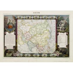
Asie.
Surround of vignettes, portraits, animals, vegetation, etc. One of the last decorative maps of the area. In original out-line color. The outer cartouches with later color...
Place & Date: Paris 1848
Selling price: $210
Sold
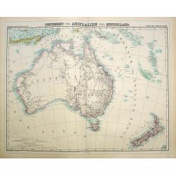
Continent von Australien und Neuseeland.
Large and detailed map of Australia and New Zealand. With color key in lower left.The map is prepared by H.Kiepert and published in Berlin by Dietrich Reimer. Engraved by...
Place & Date: Weimar, 1874-1848
Selling price: $150
Sold in 2019

Observatoire de Port Famine. (Detroit de Magellan)
Exquisite contemporary colored lithograph of the Port Famine, situated in the southern tip of America, with Dumont D'Urville's officers discussing in front of a tenth. Dr...
Place & Date: Paris, 1848
Selling price: $250
Sold in 2017

Quelpartians.
Attractive scene depicting natives of Jeju (Quelpart) Island from Marryat’s “Borneo and the Indian Archipelago”. Marryat was a mid-shipman on the H.M.S. Samaran, wh...
Place & Date: London, 1848
Selling price: $205
Sold in 2010

Carte de l'ile de Sumatra par le baron P.Melvill de Carnbee 1848. . .
Detailed map of Sumatra and the southern tip of Malacca with Singapore. Prepared in 1848 by baron P.Melvill de Carnbee and engraved by D.Heyse. From the rare work "L...
Place & Date: The Hague, Belifante freres, 1848
Selling price: $425
Sold in 2013

Kaart der vaarwaters van Soerabaya naar de trigonometrische opname van den Luit. ter Zee M.H. Jansen. . .
Chart of Surabaya the capital of the province of East Java. Prepared by Lieutenant M.H. Jansen (1817-1893) and improved in 1848 by baron P.Melvill de Carnbee. Engraved in...
Place & Date: The Hague, 1848
Selling price: $350
Sold in 2014
(Title in Russian : the Baltic Sea west of Saint Peterburg with the entrance of Neva Bay with the islands of Moshchny, Ostrov Malyy and the western tip of Kotlin Island.)
This rare chart of the Baltic Sea west of Saint Peterburg with the entrance of Neva Bay with the islands of Moshchny, Ostrov Malyy, and the western tip of Kotlin Island.B...
Place & Date: Saint Petersburg, 1848
Selling price: $300
Sold in 2011

Mepkatopckar... (Title in Russian : Baltic Sea east of Helsinki with Kotka and the Islands of Gogland and Moshchny.)
This rare chart of the Baltic Sea east of Helsinki with Kotka and the Islands of Gogland and Moshchny until the Russian coast. Based on the work of Gavril Andreyevich Sar...
Place & Date: Saint Petersburg, 1848
Selling price: $300
Sold in 2011

Arribo de Albina Steffanoni a la Isla de CUBA. 1848.
Fine manuscript map of Cuba made on the occasion of the visit of soprano Balbina Steffenone to Cuba in 1848. The map is carefully drawn and heightened by watercolors, orn...
Place & Date: Habana, 1848
Selling price: $500
Sold in 2022
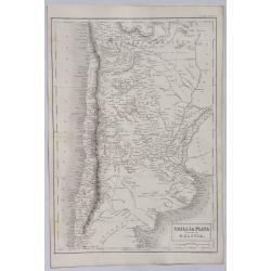
Chili, La Plata and Part of Bolivia.
A detailed map of South America from Adam & Charles Black who were among the leading publishers of atlases and travel books in the 19th Century in England. Engraved b...
Place & Date: Edinbourgh, 1849
Selling price: $7
Sold in 2021
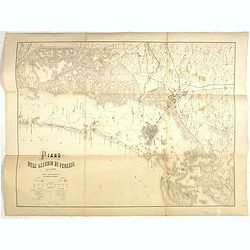
Plano dell'assedio di Venezia.
Lithographed plan of the siege of Venice (28 April – 22 August 1849). Showing in a colored key the positions of the Italian and Austrian troops. Engraved by M.Cellai.
Place & Date: Milan, after 1849
Selling price: $50
Sold in 2022
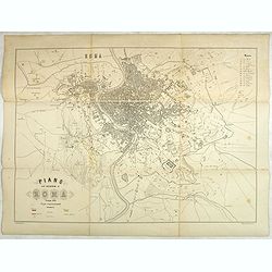
Plano dell'assedio di Roma.
Large lithographed plan of the siege of Rome in June 1849. Showing in a colored key the positions of the Roman and French troops. Engraved by M.Cellai.Siege of Rome, (30 ...
Place & Date: Milan, after 1849
Selling price: $50
Sold in 2020

Asiatischer Archipel und Neu Holland 1847 / Der Grosse Ocean und Australien 1849.
Two interesting steel engraved maps of Southeast Asia and the Pacific.(1) Asian Archipelago and New Holland 1847: The map shows Australia as well as Indonesia, Malacca (M...
Place & Date: Hildburghausen, 1849
Selling price: $25
Sold in 2021

Map of the Districts and Countries of Great Japan
This is a spectacular, large format folding map of Japan by Takashiba Ei'San'Yu, dated 1849. The map presents the primary Japanese islands of Kyushu, Honshu, Shikoku and ...
Place & Date: Japan, 1849
Selling price: $800
Sold in 2023
(Title in Russian : the Baltic Sea with Tallinn with the island of Naissaar.)
This rare chart of the Baltic Sea with the town of Tallinn and with the island of Naissaar.Based on the work Gavril Andreyevich Sarychev (1763-1831) which work was expend...
Place & Date: Saint Petersburg, 1846-1849
Selling price: $400
Sold in 2013
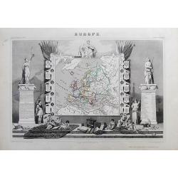
EUROPE
Charming map of the continent, surrounded by coats of arms (France, England, Spain, Italy, Switzerland, Russia, Prussia, Germany, Turkey...). Columns on the sides contain...
Place & Date: Paris, 1849
Selling price: $64
Sold in 2012