.jpg)
Browse Listings in Europe > Netherlands > Holland - North

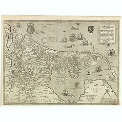
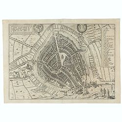
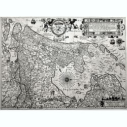
HOLLAND.
One of the oldest (woodcut)maps of the county of Holland, also partly covering areas of Zeeland,Frisia, Gelre and Brabant. North orientated to the top. It shows the main ...
Place & Date: Basle 1552
Selling price: $180
Sold
![[Amsterdam]](/uploads/cache/25711-250x250.jpg)
[Amsterdam]
Attractive bird's-eye view of the city Amsterdam. One of the oldest plans of the town. From a French text edition of Münster's Cosmographia, with text and portrait of Er...
Place & Date: Basel, ca. 1554
Selling price: $30
Sold in 2009

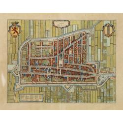
Amsterdam.
One of the oldest plans of Amsterdam, from the first edition of the book by Lodovico Guicciardini, Descrittione di tutti i Paesi Bassi, in its French translation from 156...
Place & Date: Antwerp, 1567
Selling price: $400
Sold in 2015
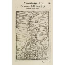
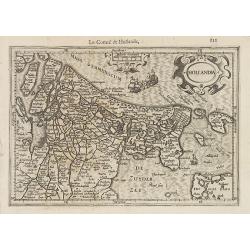
De la comte de Holande & de l' eveche du.. Utrecht.
Decorative woodblock map centered on the regions of Holland and Utrecht, in the Netherlands.From a French edition of Munster's Cosmographia Universalis.
Place & Date: Basel 1552 - 1568
Selling price: $121
Sold
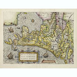
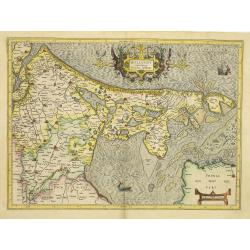
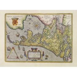
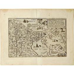
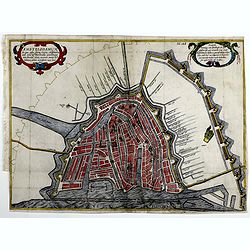
Hollandiae Antiquorum.
A first state of this mile stone map published by Ortelius on the basis of the map drawn by Jacob van Deventer in abt. 1550. Here from the very first 1570 edition of the ...
Place & Date: Antwerp, 1570
Selling price: $1300
Sold in 2013
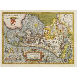
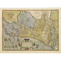
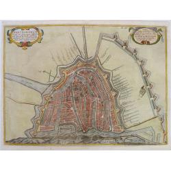
Hollandiae Antiquorum Catthorum sedis Nova Descriptio.
A fine and decorative, early map if the Duchy of Holland in the first state by Abraham Ortelius, from his "Theatrum Orbis Terrarum", Antwerp 1570, after a Jacob...
Place & Date: Antwerp, 1570
Selling price: $900
Sold in 2023
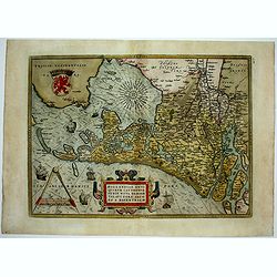
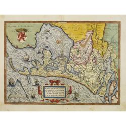
Hollandiae Antiquorum.
This map was published by Ortelius on the basis of the map drawn by Jacob van Deventer in abt. 1550. In the Spanish text on verso Ortelius marvels that such a small count...
Place & Date: Antwerp 1574-1575
Selling price: $1150
Sold
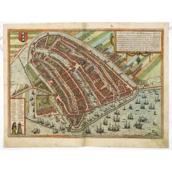
Amstelredamum, Nobile Inferioris Germaniae Oppidum . . . (Amsterdam)
Very desirable and early town-plan of Amsterdam from a north-easterly direction. With a numbered key (1-28) in lower left corner. "On the left-hand side we can see h...
Place & Date: Cologne, (1572) 1577
Selling price: $1000
Sold in 2014
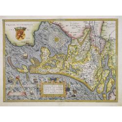
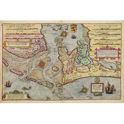
Nova et Castigator Comitatus Hollandiae Descriptio . . .
A second state of the first plate of the province of North and South Holland in the Netherlands. With the engraved signature of Joannes and Lucas van Deutecum in the lowe...
Place & Date: Antwerp, ca. 1578
Selling price: $2350
Sold in 2015

Amstelredamum, Nobile Inferioris Germaniae Oppidum . . . (Amsterdam)
Very desirable and early town-plan of Amsterdam from a north-easterly direction. With a numbered key (1-28) in lower left corner. "On the left-hand side we can see h...
Place & Date: Cologne, (1572) 1578
Selling price: $480
Sold in 2017

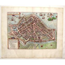
Barhasste Contraschtung der Statt Haerlem.
Very attractive and detailed birds-eye plan of Haarlem, Holland showing the full extent of rivers and moated fortification. It is set in a page of Old German text with te...
Place & Date: Basel, 1578
Selling price: $40
Sold in 2018

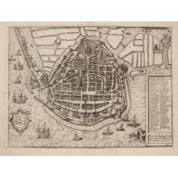
Die Stadt Enchuijsen. . .
Plan of Enkhuizen, birthplace of Lucas Waghenaer. Lower left title cartouche with coat of arm and extensive key to principal places and houses in town. Enkhuizen was one ...
Place & Date: Cologne, 1580
Selling price: $600
Sold in 2013
![[Amsterdam]](/uploads/cache/26044-250x250.jpg)
[Amsterdam]
Very early birds-eye view of Amsterdam. From his Cosmographia, that great compendium of Renaissance knowledge. An exciting print.Sebastian Münster was born in Nierder-In...
Place & Date: Basle, 1550-1580
Selling price: $50
Sold in 2008

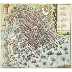
Amstelredamum, nobile Inferioris Germaniae. . .
A bird's-eye town-plan of Amsterdam, surrounded by a stormy sea. With a strapwork title cartouche, and 2 figures below the extensive key.From the greatest publication in ...
Place & Date: Cologne, 1580
Selling price: $900
Sold in 2013
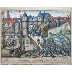
Waß gestaltt die Prinsigsche die Statt Amstelredam erwischen und innemen am 23. Nouemb. 1577.
Scarce view by Hogenberg with caption in German below the image. Shows the landing of the military forces in Haarlemmerpoort under the command of Hillside and Ruychaver t...
Place & Date: Cologne, ca. 1580
Selling price: $120
Sold in 2015
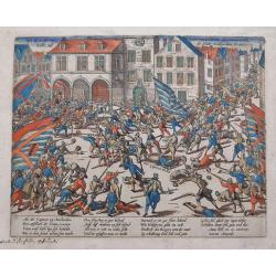
Wie die Burger von Amstelredam der Staten Volck Wider auß der Statt treiben Anno D. 1577.
Scarce view by Hogenberg with caption in German below the image. Shows the battle of when the troops of the fallen Captain Hillich are driven out of the city.
Place & Date: Cologne, ca. 1580
Selling price: $120
Sold in 2015

Amstelredamum, nobile Inferioris Germaniae. . .
A bird's-eye town-plan of Amsterdam, surrounded by a stormy sea. With a strapwork title cartouche, and 2 figures below the extensive key.From the greatest publication in ...
Place & Date: Cologne, 1580
Selling price: $650
Sold in 2021
Hollandiae Cattorum regionis typus.
Guicciardini's reduced version of Jacob van Deventer's survey of the province of Holland surveyed in 1537 and published first in Antwerp in nine sheets by Bernard van der...
Place & Date: Antwerp, 1582
Selling price: $220
Sold in 2011
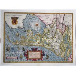
Hollandiae Antiquorum Catthorum Sedis Nova Descriptio . . .
Ortelius' atlas publication of Jacob van Deventer's survey of the province of Holland surveyed in 1537 and published first in Antwerp in nine sheets by Bernard van der Pu...
Place & Date: Antwerp, ca.1584
Selling price: $900
Sold in 2012
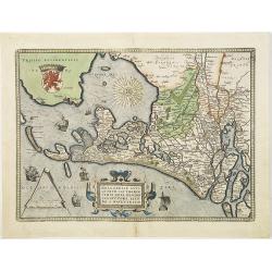
Hollandiae Antiquorum.
A mile stone map published by Ortelius on the basis of the map drawn by Jacob van Deventer in abt. 1550. Decorated with a large strapwork title cartouche, scale of miles ...
Place & Date: Antwerp, 1584
Selling price: $690
Sold in 2015
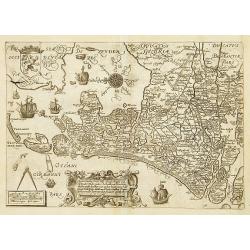
Beschrijvinge vande vermaerde stroemen, Tvlie ende Tmaersdiep: opstreckende Inde Zijder Zee voerby Enchuijsen tot Amsterdam. . .
A detailed chart of the coast of Holland decorated by several cartouches with several colorful cartouches, scale cartouches, compass roses, 5 vessels and 2 sea monster. F...
Place & Date: Leiden, Plantijn, 1585
Selling price: $3500
Sold in 2009
Gouda, elegantiss. Hollandiae Opp. ad Isalam amnem, ubi Goudam flu. à quo Oppidum nomen habet, absorbet. 1585.
A bird's-eye town-plan of Gouda. From the greatest publication in this genre!. The Civitates was compiled and written by George Braun, Canon of Cologne Cathedral. Braun g...
Place & Date: Cologne, 1585
Selling price: $100
Sold in 2021
Caarte vanden .. Graefschappe van Hollandt..
Early map of Holland, engraved by Saenredam. Based on a map by Jacob van Deventer (1550). East is at the top. In the lower part, a typical 16th-century cartouche in Renai...
Place & Date: Antwerp 1590
Selling price: $380
Sold
![Holandt. [Holland].](/uploads/cache/26999-250x250.jpg)
Holandt. [Holland].
On verso an early map of Holland (215x140 mm). From a German text edition of his Geographia , that great compendium of Renaissance knowledge.
Place & Date: Basle, 1550-1590
Selling price: $60
Sold in 2010
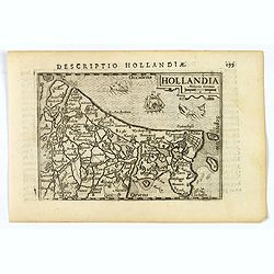
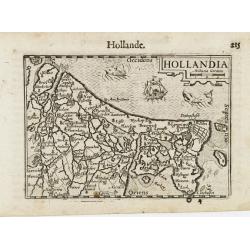
Holland. . .
On recto a map of the provinces of North and South Holland in the Netherlands. />From a Latin text edition of his Geographia , that great compendium of Renaissance kno...
Place & Date: Basle, 1550-1590
Selling price: $100
Sold in 2013
![[Amsterdam]](/uploads/cache/32574-250x250.jpg)
[Amsterdam]
On verso an early birds-eye town-plan of Amsterdam. The wood block print is showing hundreds of individual buildings and houses. Ships in the harbor and the Amstel River....
Place & Date: Basle, 1550-1590
Selling price: $75
Sold in 2013
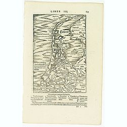
Holad.
A very early woodcut map from a Latin edition of Münsters famous 'Cosmographie'. It shows the area from Ameland until Bergen including many famous cities. With a ship sh...
Place & Date: Basel, ca 1590
Selling price: $36
Sold in 2019
Hollandt comitatus Utrecht episcop.
The rare first edition, with a large marshland in the Zuiderzee filled with ducks.The country of Holland, i.e.: present Noord- and Zuid-holland, plus Utrecht. Oriented we...
Place & Date: Duisburg, 1593
Selling price: $375
Sold in 2011
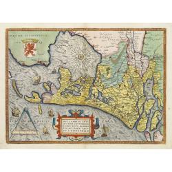
Hollandiae Antiquorum Catthorum..
Prepared by Jacob van Deventer in 1550. It shows Holland in great detail, including small towns, walled cities, rivers and lakes (many of which were reclaimed in the 17th...
Place & Date: Antwerp 1602
Selling price: $850
Sold
Hollandiae Antiquorum Catthorum. . .
Prepared by Jacob van Deventer in 1550. It shows Holland in great detail, including small towns, walled cities, rivers and lakes (many of which were reclaimed in the 17th...
Place & Date: Antwerp, 1602
Selling price: $1400
Sold in 2008
Hollandiae Antiquorum Catthorum. . .
Prepared by Jacob van Deventer in 1550. It shows Holland in great detail, including small towns, walled cities, rivers and lakes (many of which were reclaimed in the 17th...
Place & Date: Antwerp, 1602
Selling price: $750
Sold in 2016
Hollandiae Antiquorum.
A third state of this mile stone map published by Ortelius on the basis of the map drawn by Jacob van Deventer in abt. 1550. Decorated with a large strapwork title cartou...
Place & Date: Antwerp, 1603
Selling price: $555
Sold in 2015
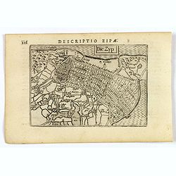
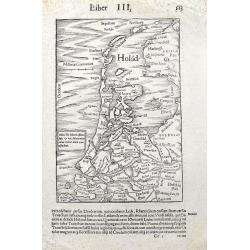
Die Zyp.
A lovely miniature map of the Zijpepolder in The Netherlands, published by Petrus Bertius, in Amsterdam at the beginning of the seventeenth century. There is a small rect...
Place & Date: Amsterdam, 1606
Selling price: $50
Sold in 2020
Hollandiae.
An original early 17th century copper engraved miniature antique map of Holland by Petrus Bertius, that was published in Amsterdam at the beginning of the seventeenth cen...
Place & Date: Amsterdam, 1606
Selling price: $60
Sold in 2019
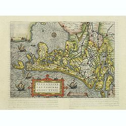
Hollandia Occidens.
Quad's atlas publication of Jacob van Deventer's survey of the province of Holland surveyed in 1537 and published first in Antwerp in nine sheets by Bernard van der Putte...
Place & Date: Cologne 1592 - 1608
Selling price: $360
Sold
Hollandia.
Small map of the province Holland, with strapwork title cartouche and scale of miles cartouche.From the first French-text edition of Jodocus Hondius' Atlas Minor.Shortly ...
Place & Date: Amsterdam, 1608
Selling price: $100
Sold in 2022
Holandia / Hollande.
A miniature map of Holland. Title cartouche on the upper right corner. The sea is decorated with two fantastic animals and a ship.First published in 1598 in his Caert-Thr...
Place & Date: Amsterdam/Frankfurt 1609
Selling price: $100
Sold
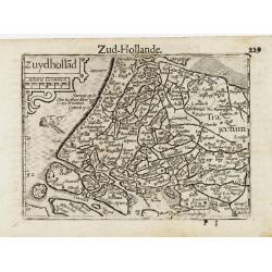
Zyudhollad / Zud Hollande.
A miniature map of Holland. Title cartouche on the upper left corner. The sea is decorated with a ship.First published in 1598 in his Caert-Thresoor, the plates were exec...
Place & Date: Amsterdam / Frankfurt, 1609
Selling price: $100
Sold
Hollandiae Cattorum regionis typus.
Guicciardini's reduced version of Jacob van Deventer's survey of the province of Holland surveyed in 1537 and published first in Antwerp in nine sheets by Bernard van der...
Place & Date: Antwerp, 1609
Selling price: $250
Sold in 2011
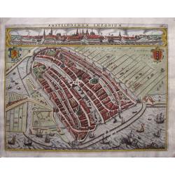
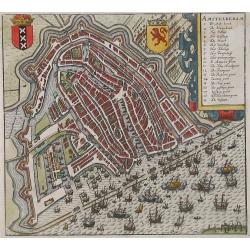
Amstelodamum Emporium
One of the oldest maps and views of Amsterdam, elegantly engraved by Jodocus Hondius the elder in 1611. The map depicts the view of Amsterdam in the beginning of its expa...
Place & Date: Amsterdam, 1611
Selling price: $1700
Sold in 2014
Amstelredam
Nice bird's-eye view of the city of Amsterdam. First state copper engraving from Guicciardini's first dutch edition "Beschryvinghe van alle de Nederlanden" edit...
Place & Date: Amsterdam 1612
Selling price: $475
Sold
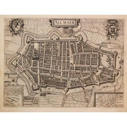
Alcmaer.
From Ludovico Guicciardini.'s description of the Netherlands ' Beschrijvinghe van alle de Nederlanden anderssins ghenoemt Neder-Duytslandt ', published by Willem Blaeu.A ...
Place & Date: Amsterdam, W.Blaeu, 1612
Selling price: $75
Sold in 2019
Die Stadt Enchuijsen.
From Ludovico Guicciardini.'s description of the Netherlands ' Beschrijvinghe van alle de Nederlanden anderssins ghenoemt Neder-Duytslandt ', published by Willem Blaeu.A ...
Place & Date: Amsterdam, W.Blaeu, 1612
Selling price: $140
Sold in 2009
![De borse van Amsterdam [Stock exhange of Amsterdam]](/uploads/cache/09117-250x250.jpg)
De borse van Amsterdam [Stock exhange of Amsterdam]
Fine early view of the stock exchange of Amsterdam.Ludovico Guicciardini was a nobleman from Florence, who lived and worked in the Low Countries, and died at Antwerp in 1...
Place & Date: Amsterdam, 1613
Selling price: $150
Sold
Amstelodamum.
This rare state of one of the oldest maps and views of Amsterdam depicts an early view and the further expansion of it´s windmill dykes in the beginning of the 17th cent...
Place & Date: Amsterdam, 1614
Selling price: $590
Sold in 2019
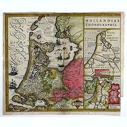
Hollandiae Chorographia
In 1611 Isaac Pontanus, published his “Rerum et urbis Amstelodamensium historia” in Amsterdam. This print comes out of the even rarer Dutch translation "Historis...
Place & Date: Amsterdam, 1614
Selling price: $340
Sold in 2019
Amstelodamum.
One of the oldest plans of Amsterdam from the beginning of the 17th century. An earlier but incomplete state was published in 1611, due to the desire to quickly publish t...
Place & Date: Amsterdam, 1614
Selling price: $450
Sold in 2019
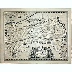
Agri Zypani Nova Descript.
Fine map, first state, of the new distribution of the Zype. From the famous first separately issued atlas of the Low Countries by Pieter van den Keere in the year 1617: P...
Place & Date: Amsterdam, 1617
Selling price: $125
Sold in 2020
Hollandia.
First edition. Pieter Van Den Keere-often known as Kearius- was an active Dutch engraver best known for his collection of pocket-sized maps of the British Isles in about ...
Place & Date: Amsterdam, 1617
Selling price: $1650
Sold in 2017
![[ lot of 14 maps/views] Caerte vanden lande ende Graefschappe van Hollandt, Midtsgaders het landt van Utrecht, de deelen ende houcken van andere lande annex hollt gelege. 1589.](/uploads/cache/19042-250x250.jpg)
[ lot of 14 maps/views] Caerte vanden lande ende Graefschappe van Hollandt, Midtsgaders het landt van Utrecht, de deelen ende houcken van andere lande annex hollt gelege. 1589.
The third state of Jan Pietersz. Saenredam attractive map of Holland. From Ludovico Guicciardini' s 'Les Description de touts les Pays-Bas', publised by Willem Blaeu in 1...
Place & Date: Amsterdam, c. 1620
Selling price: $200
Sold in 2022

Amstelredamum, nobile Inferioris Germaniæ oppidum
A map of Amsterdam in bird-eye view, seen from the Northeast, the IJ river at front with many ships. Title and extensive description at top right, at bottom left legends ...
Place & Date: Cologne, 1618-1623
Selling price: $800
Sold in 2022

Die stadt Enchuijsen.
Detailed copper engraved city map of Enkuizen, Netherlands by Lodovico Guicciardini and published by Janssonius. Highly decorated with dozens of ships, windmills and a me...
Place & Date: Amsterdam, Janssonius, 1625
Selling price: $65
Sold in 2013
Hooren in Westvrieslant.
Copper engraved map by Lodovico Guicciardini and published by Janssonius. Detailed city map featring Hoorn, Netherlands. Includes god riding sea monster and dozens of de...
Place & Date: Amsterdam, Janssonius, 1625
Selling price: $60
Sold in 2013

Hooren in Westvrieslant.
Attractive and decorative plan of Hoorn. Showing the town with the city walls, surrounding fields, and the harbour with sailing ships. Published in "Description de t...
Place & Date: Amsterdam, 1625
Selling price: $65
Sold in 2012
![[Lot of 10 maps/plans] Hollandia Comitatus.](/uploads/cache/18973-(1)-250x250.jpg)
[Lot of 10 maps/plans] Hollandia Comitatus.
Matthäus Merian (1593-1650). Engraver and publisher of Frankfurt. Theatrum Europaeum 1629-1718, Topographie 1642-88, Gotofred Newe Archontologica Cosmica 1638 and 1649.A...
Place & Date: Fankfurt, c. 1625
Selling price: $200
Sold in 2022

Comitatus Hollandiae.
A first edition of one of the most decorative carte à figures maps of Holland. Superbly engraved by Abraham Goos. The map is framed on al sides by decorative borders. Th...
Place & Date: Amsterdam, 1630
Selling price: $3100
Sold in 2009

Totius Hollandiae Septentrionalis vulgo Westfrisiae novissima tabula. . .
A small, highly detailed map of Northern Holland, including the Westfrisia region, published by Henricus Hondius(fl. 1624-1651) based on the survey by Floriszoon van Berc...
Place & Date: Amsterdam, 1632
Selling price: $110
Sold in 2010

Hollandia Comitatus.
Highly detailed regional map of Holland, with an inset of the Dutch Islands of Texel, Vlielandt, etc. Includes a rampant lion, 3 cartouches, sailing ships and 3 compass r...
Place & Date: Amsterdam, 1635
Selling price: $280
Sold in 2014

Queen Maria of France arriving at Amsterdam.
Panoramic view of the city from 't IJ. On the foreground extensive shipping being the arrival on August 31, 1638.The print was published in commemoration of Maria de 'Med...
Place & Date: Amsterdam 1639
Selling price: $845
Sold
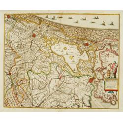
Rhinolandiae, Amstelandiae et ..
Centered on The Hague, Leiden, Haarlem, Amsterdam, Gouda, etc. West to the top. Prepared by Balthasar Floris van Berkenrode.
Place & Date: Amsterdam, 1639
Selling price: $550
Sold

La Hollande Septentrionale.
Large map of the northern part of the province "Holland" in the Netherlands. The map comes from the "Atlas Novus" originally published by Janssonius i...
Place & Date: Amsterdam, 1639
Selling price: $170
Sold in 2011

No title: Map of northern tip of Holland
The northern tip of Holland or West Friesland. West to the top. Including Amsterdam, Alkmaar, Hoorn, Enkhuizen, etc. Many ships in the Noord- and Zuiderzee.
Place & Date: Amsterdam 1639
Selling price: $325
Sold

Amsterdam.
Bird's eye view of the busy harbour of Amsterdam with the city shown in plan. Individual buildings can be seen with gardens behind them. Clearly shows the canal system, c...
Place & Date: Frankfurt, 1640
Selling price: $300
Sold in 2009

Comitatus Hollandiae novissima description Designatore Balthazaro Florentio a Berckenrode Anno Domini 1629.
Highly detailed regional map of Holland, showing the area around Amsterdam, Utrecht, Rotterdam, with an inset upper right corner of the Dutch Islands of Texel, Vlielandt....
Place & Date: Amsterdam, 1640
Selling price: $350
Sold in 2020

Hollandia.
The Allardt edition of Blaeu's map of Holland, first published in 1604, being the oldest Dutch map to include town views as decorative borders. The top and bottom borders...
Place & Date: Amsterdam, 1640
Selling price: $3750
Sold in 2024
Hollandiae pars septentrionalis, Vulgo Westvriesland..
Based on the work of B.F.van Berckenrode, this fine map, orientated west to the top of the sheet, includes Kennemerland and Hollands Noorderkwartier and is a reasonably u...
Place & Date: Amsterdam, 1645
Selling price: $100
Sold in 2017
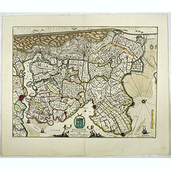
Rhenolandiae et Amstellandiae.
Encompasses the area between 's-Gravenhage and Gouda in the south, to Beverwijk in the north. Large expanse of the Haarlemmermeer occupies the center of the plate. A very...
Place & Date: Amsterdam, 1645
Selling price: $210
Sold in 2019
Hollandiae pars septentrionalis, Vulgo Westvriesland..
Based on the work of B.F.van Berckenrode, this fine map, orientated west to the top of the sheet, includes Kennemerland and Hollands Noorderkwartier and is a reasonably u...
Place & Date: Amsterdam, 1645
Selling price: $110
Sold in 2019
Hollandiae pars septentrionalis, Vulgo Westvriesland en 't Noorder Quartier.
Based on the work of B.F.van Berckenrode, this fine map, orientated west to the top of the sheet, includes Kennemerland and Hollands Noorderkwartier and is a reasonably u...
Place & Date: Amsterdam 1647
Selling price: $500
Sold
Hollandiae pars septentrionalis, Vulgo Westvriesland..
Based on the work of B.F.van Berckenrode, this fine map, orientated west to the top of the sheet, includes Kennemerland and Hollands Noorderkwartier and is a reasonably u...
Place & Date: Amsterdam 1647
Selling price: $350
Sold
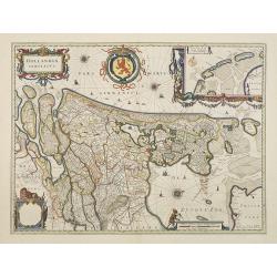
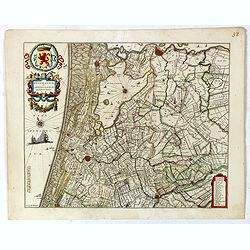
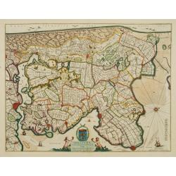
Hollandia Comitatus.
Orientated west to the top of the sheet, this represents the County of Holland in the classical orientation for seventeenth century maps, with Amsterdam at the centre. Th...
Place & Date: Amsterdam, 1647
Selling price: $1950
Sold in 2009
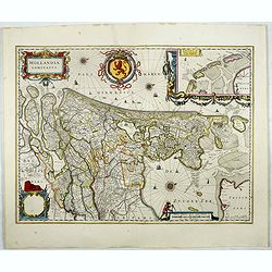
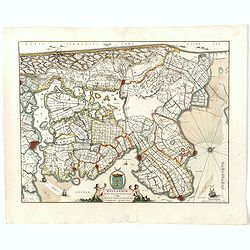
Hollandia Comitatus.
Orientated west to the top of the sheet, this represents the County of Holland in the classical orientation for seventeenth century maps, with Amsterdam at the centre. Th...
Place & Date: Amsterdam, 1647
Selling price: $600
Sold in 2017
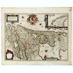
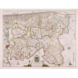
Hollandia Comitatus.
Orientated west to the top of the sheet, this represents the County of Holland in the classical orientation for seventeenth century maps, with Amsterdam at the center. Th...
Place & Date: Amsterdam, 1647
Selling price: $100
Sold in 2019
Amstelredam
Nice handcolored copper engraving picturing the city of Amsterdam. From the 1648 edition of Guicciardini's famous work Description of the Netherlands issued by J. Jansson...
Place & Date: Amsterdam 1648
Selling price: $500
Sold
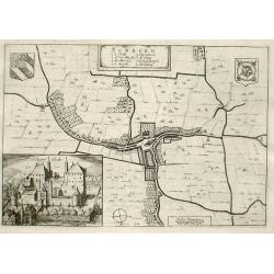
Schagen
Fine map of the town of Schagen with inserted a nice engraving of the Castle of Schagen.Copper engraving from Joan Blaeu's Toneel der Steden (townbook) 1649.Dutch text on...
Place & Date: Amsterdam 1649
Selling price: $110
Sold
Delfi Batavorum vernacule Delft.
Detailed plan of the city Delft from Joan Blaeu\'s town book of the Netherlands, first published one year after the peace of Munster and the Spanish acknowledgement of th...
Place & Date: Amsterdam, 1649
Selling price: $2200
Sold in 2010
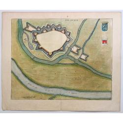
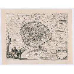
Doesburgh.
A nicely colored town plan of Doesburg in northeastern Holland, shown in an unusual panoramic birds-eye view, circa 1649. It features the fortress walls and a few cottage...
Place & Date: Amsterdam, 1649
Selling price: $37
Sold in 2019
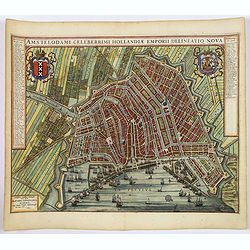
(Amsterdam)Amstelodami Celeberrimi Hollandiae Emporii delineatio nova.
A very attractive bird's-eye view of this most important European city, engraved at the height of the 'Golden Age' of Dutch cartography, when it sat at the hub of one of ...
Place & Date: Amsterdam, 1649
Selling price: $1750
Sold in 2019
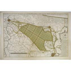
Afbeeldinge van Zeker Concept tot Bedykinge, van de Haarlemer, Leydse en Andere byleggende Meeren.
Large, rare, and detailed map of the region between Amsterdam, Haarlem and Leiden, from two copperplates. It concerns a concept to reclaiming the Haarlemmermeer, drawn by...
Place & Date: Amsterdam, 1650
Selling price: $275
Sold in 2019
Veroveringe van Thienen Anno 1635
Birds eye view of the conquest of Tienen by the national army led by Frederik Hendrik, 1 June 1635, from : "I. Commelin, Frederick Hendrick van Nassauw Prince van Or...
Place & Date: Amsterdam 1651
Selling price: $25
Sold in 2020