.jpg)
Browse Listings in Europe > Netherlands
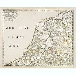
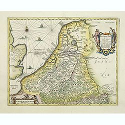
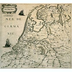
Provinces unies des Pays Bas. Par N. Sanson d'Abbeville. . .
Fine map of the present-day Netherlands. This edition carries un unfinished date "166 " and was engraved by R.Cordier Abbauil.Nicolas Sanson was to bring about ...
Place & Date: Paris, after 1660
Selling price: $225
Sold in 2014
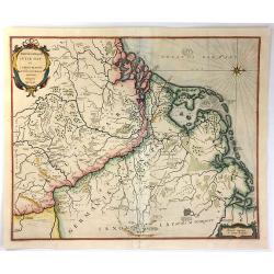
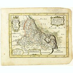
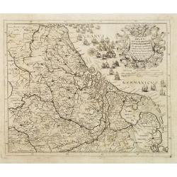
Patriae Antiuae Inter Iuly et Caroli Magni Caesarium Romanorum Tempora Descriptio
An iInteresting map by Jan Janssonius of the “Low Countries and Northern Germany”. The compass rose orients this map with north to the right. The map describes the p...
Place & Date: Amsterdam, 1660
Selling price: $67
Sold in 2016
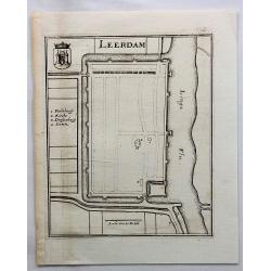
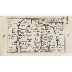
Leerdam.
Small map of fortified Leerdam, located in Gelderland, Holland.
Place & Date: Frankfurt, ca. 1660
Selling price: $8
Sold in 2017

Bommel.
Den Bommel is a village in the Dutch province of South Holland. It is a part of the municipality of Goeree-Overflakkee. This town view is detailed especially in regard to...
Place & Date: Frankfurt, 1660
Selling price: $145
Sold in 2018

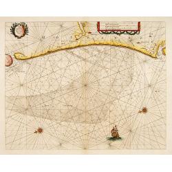
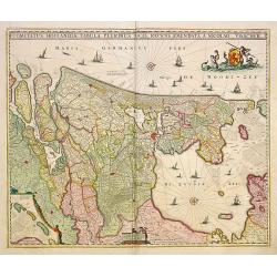
Delflandia, Schielandia. . .
This detailed road map shows the estuary of the River Maas and extends.
Place & Date: Amsterdam, ca. 1660
Selling price: $50
Sold in 2017

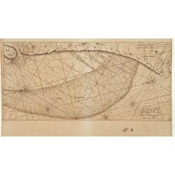
Delflandia, Schielandia. . .
This detailed road map shows the estuary of the River Maas and extends from 's-Gravenhage to Gouda in the north and from Ouddorp to Steenbergen in the south. Cities, such...
Place & Date: Amsterdam, ca. 1660
Selling price: $95
Sold in 2018
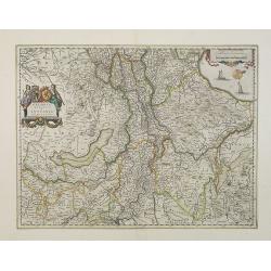
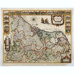
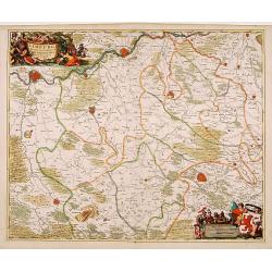
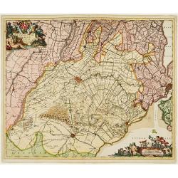
Geldria Ducatus et Zutphania Comitatus.
Map of Gelderland orientated west at the top, including Northern Limburg, eastern part of Brabant, Veluwe and Zutphen. Including the towns of Utrecht, Enschede, Rhunbeck,...
Place & Date: Amsterdam, 1661
Selling price: $400
Sold in 2009

Delflandia, Schielandia.
Based ultimately on the large wall map by Balthazar Florisz van Berckenrode(1620-21), this finely engraved map shows the estuary of the River Maas and includes the area f...
Place & Date: Amsterdam 1661
Selling price: $601
Sold
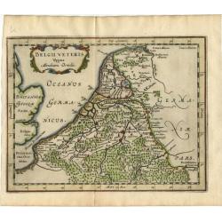
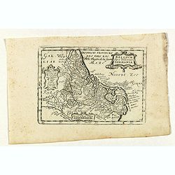
Belgii Veteris Typus Abrahami Ortelii.
Small map of this historic region with many ancient place names based on the map of Abraham Ortelius. The map is decorated with a delicate title cartouche.
Place & Date: Amsterdam 1661
Selling price: $100
Sold
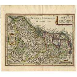
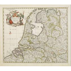
Belgii sive Germaniae Inferioris
Small map engraved by Petrus Kaerius, this map is filled with mountains, cities and villages. The map is oriented with north at right and is decorated with strapwork titl...
Place & Date: Amsterdam 1661
Selling price: $110
Sold
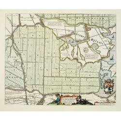
Agri Biemstrani Descriptio a L.I.S.
Detailed map of the polder Beemster in Noord Holland. Including the towns of Purmerend, De Ryp, Oudendijk, etc.
Place & Date: Amsterdam, 1661
Selling price: $275
Sold in 2019

Hodiernae Belgicae sive Germaniae Infezrioris Tabula.
Interesting map of the Low Countries from a German edition of Philipp Clüver's famous Introductionis in Universam geographicam, first published in Leiden in 1624. Philip...
Place & Date: Wolfenbüttel, 1661
Selling price: $50
Sold in 2008
Ultraiectum Dominium.
Based on the map by B.F.van Berckenrode (1620-21).
Place & Date: Amsterdam, 1661
Selling price: $200
Sold in 2021
Caerte van de Scher-meer Alsoo deselve is Bedyckt, ende by Cavels van 15 Morgen suyver landt door lotinge uytgedelt, op den 25 October Anno 1635, ende aldus met groote verbeteringe int licht gegeven.
Attractive map of the polder Schermer near Alkmaar by Cornelis Ian allers Bogaert and published by Blaeu. At the lower right side a coat of arms of Schermer. In the lower...
Place & Date: Amsterdam, 1661
Selling price: $400
Sold in 2019
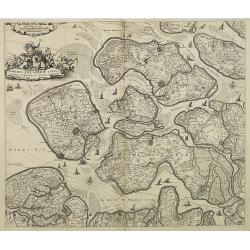
Kaerte van de vier ambachten.
Uncommon map of the ‘Vier Ambachten’ in Zeeuws-Vlaanderen. The map covers the area of IJzendijke, Biervliet, Sas van Gent, Axel, Hulst, Lillo and parts of Zuid-Bevela...
Place & Date: Amsterdam, 1661
Selling price: $26
Sold in 2019
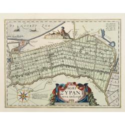
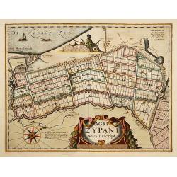
Agri Zypani Nova Descript.
Fine map of the region of the Zype. From a Latin text edition of the Atlas Maior.The copperplate was originally by Petrus Kearius, but was considerably revised by Joan Bl...
Place & Date: Amsterdam, 1662
Selling price: $500
Sold in 2011
Le Comte de Hollande.
Map of northern Holland by Jaillot after Sanson; shows Amsterdam at the very bottom.
Place & Date: Paris, 1662
Selling price: $60
Sold in 2010
Belgii Veteris Typus ex Conatibus Geographicis Abrahami Ortelii. . . Petrus Kaerius Caelavit.
Ancient map of present Netherlands, Belgium and Luxemburg. Title cartouche on the upper right corner, giving credit to Abraham Ortelius. Engraved by Petrus Kaerius.
Place & Date: Amsterdam, 1662
Selling price: $150
Sold in 2011
Belgium sive Inferior Germania. (27).
Scarce map of the Netherlands and Belgium published by Antoine de Fer in 1661 or 1662 in "Cartes de géographie revues et augmentées".With number 27 in lower r...
Place & Date: Paris, Antoine de Fer, 1657 but 1661 or 1662
Selling price: $40
Sold in 2020
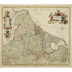
Nova XVII Provinciarum Inferioris Germaniae Descriptio.
An early and rare map by de Wit of the 17 provinces. The map was originally engraved by P. Kaerius in 1607, and later came into the possession of de Wit, who re-engraved ...
Place & Date: Amsterdam 1662
Selling price: $900
Sold in 2022
Agri Zypani Nova Descript.
Fine map of the region of the Zype. From a French text edition.The copperplate was originally by Petrus Kaerius, but was considerably revised by Joan Blaeu for his Atlas ...
Place & Date: Amsterdam, 1663
Selling price: $275
Sold in 2019
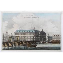
Een ander gesicht van 'T LANDTS MAGAZYN.
A decorative print of the 'T Landts Magazyn, formerly the V.O.C. warehouse and arsenal for the Admiralty of Amsterdam, now-a-days the Scheepvaartmuseum (Maritime Museum)....
Place & Date: Amsterdam, 1663
Selling price: $200
Sold in 2023

La Cour du Prince ou College de l'Admirauté. - HET PRINCEN HOF.
Decorative view of the "Prinsen Hof" in Amsterdam, now-a-days the "Hotel The Grand".Published in a French edition of "Historische Beschrijving de...
Place & Date: Amsterdam, c.1663
Selling price: $50
Sold in 2020
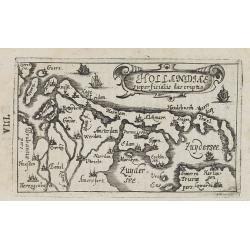
Hollandiae superficialis descriptio.
Charming little map of Holland made by Gabriel Bucelin (1599-1681). Bucelin was a Swiss genealogist and an author of several books and a number of manuscript maps of Germ...
Place & Date: Ulm, Johannes Görlin, 1658-1664
Selling price: $250
Sold in 2008
Brabantiae.
Charming little map of Brabant made by Gabriel Bucelin (1599-1681). Bucelin was a Swiss genealogist and an author of several books and a number of manuscript maps of Germ...
Place & Date: Ulm, Johannes Görlin, 1658-1664
Selling price: $90
Sold in 2008
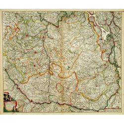
Tetrachia Ducatus Gelriae Rurmundensis.
East to the top. Covering northern part of Limburg, including the towns of Gennip, Geldern, Venlo, Roermond, Weert. In top coats of arms of 8 cities and the province. Rar...
Place & Date: Amsterdam, 1664
Selling price: $750
Sold in 2018
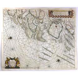
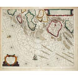
De Cust Van Zeelandt ....
A striking and highly detailed, beautiful copper engraved nautical chart of Zeeland, the westernmost province of Netherlands. Two beautiful compass roses radiating rhumb ...
Place & Date: Amsterdam, 1664
Selling price: $500
Sold in 2016
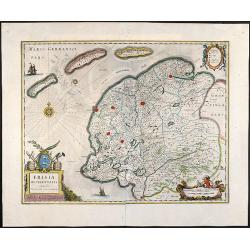
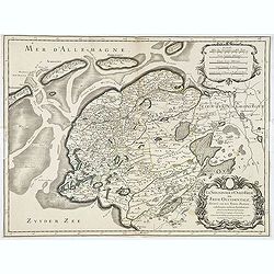
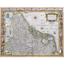
Frisia Occidentalis, Auctoribus Adriano Metio et Gerardo Freitag
Original old colored map of Friesland in northern Holland with 3 beautiful cartouches, two sailing ships and a compass rose. From \"Atlas Contractus\" published...
Place & Date: Amsterdam, 1666
Selling price: $950
Sold in 2008
Belgium sive inferior Germania.
Rare map of The Low Countries with present-day The Netherlands, Belgium and Luxemburg, published by Jollain in 1667. Published in "Trésor Des Cartes Geographiques D...
Place & Date: Paris, 1667
Selling price: $150
Sold in 2019
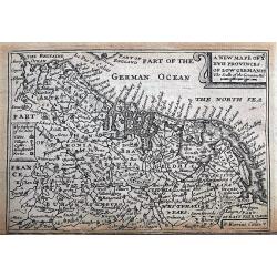
A New Mape of Ye XVII Provinces of Low Germanie.
A detailed miniature map of the Netherlands / Low Countries. From the delightful pocket edition of John Speed's atlas by Van Den Keere, who signs as P. Kaerius.
Place & Date: London, 1668
Selling price: $25
Sold in 2018
Cust van Hollant tusschen de Maes ende Texel.
Uncommon and detailed chart of the coast of Holland, including the southern tip of Texel. East at the top. Two fine compass cards, soundings and a large "Bree Veerth...
Place & Date: Amsterdam 1669
Selling price: $570
Sold
De Cust van Hollant Tussen Texel en de Maes. . .
Signed lower right-hand corner: Jacob Colom opt Water Inde Vyerige Colom. Jacob Colom (1600-1673) was a printer, publisher and bookseller in the Fiery Colom in Amsterdam....
Place & Date: Amsterdam, 1669
Selling price: $300
Sold in 2020
Totius Fluminis Rheni Novissima Descriptio.
Two maps on one sheet of the river Rhine. Original colored map following the river from Germany to the North Sea.
Place & Date: Amsterdam, 1670
Selling price: $200
Sold in 2013
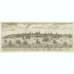
Amstelredam.
Decorative panoramic of Amsterdam, published by Marcus Willemsz. Doornick (1633 - 1703). With extensive shipping on the IJ. Underneath the engraving extensive text : Ams...
Place & Date: Amsterdam, 1670
Selling price: $130
Sold in 2012

Hollandiae pars Meridionalior vulgo Zuyd-Holland.
Detailed map covering the area around the Biesbos, including Breda, Dordrecht, Gorcum and Gouda.Cartouches with later color addition.
Place & Date: Amsterdam, 1670
Selling price: $150
Sold in 2012

Hagae Comitis celeberrimi totius Europae municipij typus.
The bird's-eye view plan of The Hague from the rare Janssonius edition of his Town book. The city is seen from the southwest and shows an impressive unfortified residenti...
Place & Date: Amsterdam, 1670
Selling price: $430
Sold in 2015
![[Lot of 4 maps] Comitatus Hollandiae Tabula Pluribus Locus Recens Emendata a Nicolao Visscher.](/uploads/cache/18172-250x250.jpg)
[Lot of 4 maps] Comitatus Hollandiae Tabula Pluribus Locus Recens Emendata a Nicolao Visscher.
The fourth state (of 5) of Claes Jansz. Visscher's attractive map of Holland, published by his grand-son Nicolaas II. Embellished with a cartouche with the coat-of-ar...
Place & Date: Amsterdam, ca. 1670
Selling price: $200
Sold in 2022
Belgii seu XVII Provincia inferioris Germanie ex optimus quibusq. . .
Very rare map of the present-day Netherlands, Belgium and Luxembourg.François Collignon, originating from Nancy, is reckoned among the great engravers of his day. He lea...
Place & Date: Rome, dated 1672
Selling price: $1250
Sold in 2008
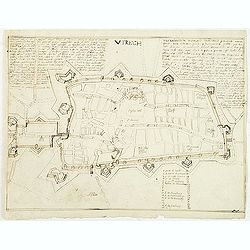
Utrech (Utrecht)
Manuscript fortification town-plan of Utrecht, as it was at about 1672. With a numbered key (1-34) pointing to the important buildings, streets and canals in town. Only 1...
Place & Date: France, ca. 1672
Selling price: $1450
Sold in 2011
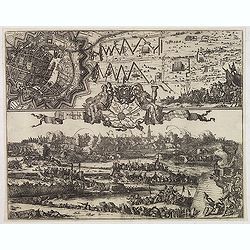
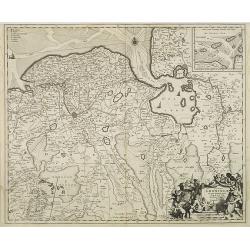
De Belegringh van Groeningen.
Very rare separately issued print of the siege Groningen. Upper left plan of Groningen, in the center a map of the surrounding areas, the city arms above and on each side...
Place & Date: Amsterdam, Marcus Doornik, ca.1672
Selling price: $230
Sold in 2013
Provinces des Pays-Bas. (The Low Countries)
Rare map of the Low Countries, published by Gualdo Priorato (1606-1678), who entered military service at a very young age and served in Flanders under the Prince of Orang...
Place & Date: Vienna, 1672
Selling price: $350
Sold in 2018

Woerden.
Plan of the Dutch town Woerden in the now-a-days province "Zuid Holland". From Priorato's book "Schauplatz dess Niderlands", printed and edited in Vi...
Place & Date: Vienna 1673
Selling price: $15
Sold
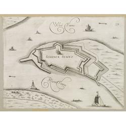
Schenkenschans.
Plan of the Dutch bastion/town Schenkenschans in the nowadays province Gelders. From Prirato's book "Schauplatz dess Niderlands", printed and edited in Vienna ...
Place & Date: Vienna 1673
Selling price: $13
Sold in 2008
Ravestein.
Plan of the Dutch town Ravestein in the nowadays province Brabant. From Priorato's book "Schauplatz dess Niderlands" printed and edited in Vienna 1673.
Place & Date: Vienna 1673
Selling price: $16
Sold
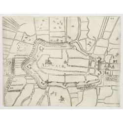
Alkmaar.
Plan of the Dutch town Alkmaar in the now-a-days province Nord Holland. From Priorato's book "Schauplatz dess Niderlands", printed and edited in Vienna 1673.
Place & Date: Vienna 1673
Selling price: $50
Sold

Den Brielle.
Plan of the Dutch town Brielle in the now-a-days province of South Holland. From Priorato's book "Schauplatz dess Niderlands", printed and edited in Vienna 167...
Place & Date: Vienna 1673
Selling price: $20
Sold
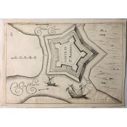
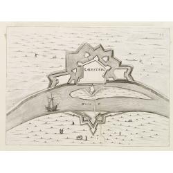
Forte di St. Andrea. (Sint Andre)
A simple copper engraving of the Sint Andre Fort build on the island of Bommel in Gelderland. The illustration is from a Italian edition of the book "Teatro del Belg...
Place & Date: Frankfurt, 1673
Selling price: $13
Sold in 2018
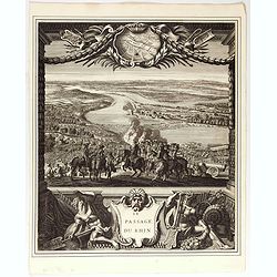
Le passage du Rhin.
Splendid engraving by Juan Dolivar van der Meulen showing the army of Louis XIV crossing the river Rhine and arriving into the Netherlands at Lobith. From the series &quo...
Place & Date: Paris, 1673
Selling price: $100
Sold in 2020
La seigneurie d'ouest-Frise ou Frise Occidentale
Fine map of the Friesland with a decorative title and scale cartouche.Alexis-Hubert Jaillot (1632-1712), was a French cartographer. He joined the Sanson heirs and redrew ...
Place & Date: Paris, 1674
Selling price: $150
Sold in 2013
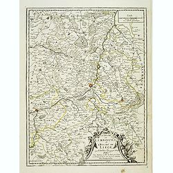
Le duché de Limbourg et l'Eveché de Liege . . .
Detailed map of the duchy of Limburg and diocese of Liege. With fine title cartouche lower right. Dated 1675.More about [+]
Place & Date: Paris, 1675
Selling price: $150
Sold in 2019
Cust van Hollant Tusschen de Maes ende Texel.
A sea-chart of the coast of Holland with the "Bree Veertien", the large shallow which lays before the coast. Embellished with two cartouches, a ship and two com...
Place & Date: Amsterdam, 1676
Selling price: $250
Sold in 2019
De Cust van Zeeland.
Theunis Jacobsz, Amsterdam-based maritime publisher added Lootsman (pilot) to his name. After his death in 1650, his sons Jacob Theunisz and Casparus continued the firm. ...
Place & Date: Amsterdam, 1676
Selling price: $1200
Sold
A New Mape of ye XVII Provinces of Low Germanie, mended a New in manie places.
Fantastic and important Carte-à-figures map of the Low Countries. With eight city views showing Amsterdam, Antwerp, Ghent, Middelburg, Groeningen, Zutphen, Utrectht and ...
Place & Date: London, 1676
Selling price: $925
Sold in 2017
Comitatus Hollandiae Tabula Pluribus Locus Recens Emendata a Nicolao Visscher.
West to the top. Very fine map of the province of Holland, here in a 4th state.
Place & Date: Amsterdam 1677
Selling price: $500
Sold in 2015
Dominii Groningae nec non maximae partis Drentiae Novissima. Delineatio per Nicolaum Visscher.
Map of Groningen and Drenthe in the north-east part of the Netherlands. Inset upper right corner of the "Wadden eilanden" entitled Caerte van de Groeninger Eyla...
Place & Date: Amsterdam, 16856-1677
Selling price: $150
Sold in 2009
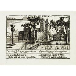
Nyenroy.
View of the castle of Nijenrode. With a verse in two languages underneath the picture.The poet Daniel Meisner from Komotau started his Thesaurus Philo-Politicus. Das ist ...
Place & Date: Frankfurt 1623-1678
Selling price: $130
Sold
![Boulenham. [ Burg Boelenham in Betuwe ]](/uploads/cache/13761-250x250.jpg)
Boulenham. [ Burg Boelenham in Betuwe ]
A very nice view of Burg Boelenham in the Betuwe, with fine details of the forest. On the foreground, a man holding a pair of scales is depicted. With a verse in two lang...
Place & Date: Frankfurt 1623-1678
Selling price: $70
Sold in 2018
![Toutenburg. [near Vollenhoven]](/uploads/cache/13795-250x250.jpg)
Toutenburg. [near Vollenhoven]
A very nice view of the castle of Toutenburg near Vollenhoven. Beside the castle a farmhouse with sheep\'s, a cow and wind mill are depicted. With a verse in two language...
Place & Date: Frankfurt 1623-1678
Selling price: $65
Sold in 2009
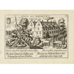
Sinderen.
A very nice view of the castle of Sinderen. With a verse in two languages underneath the picture.The poet Daniel Meisner from Komotau started his Thesaurus Philo-Politicu...
Place & Date: Frankfurt 1623-1678
Selling price: $30
Sold
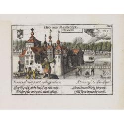
Hemmen.
A very nice view of the castle Hemmen. On the foreground, a man is depicted and to the right the river de Linge. With a verse in two languages underneath the picture.The ...
Place & Date: Frankfurt, 1623-1678
Selling price: $70
Sold in 2018

Lovenstein.
A very nice view of the castle. On the sky, three hands holding a quill, a stone and a stick are depicted. With a verse in two languages underneath the picture.The poet D...
Place & Date: Frankfurt, 1623-1678
Selling price: $15
Sold in 2023
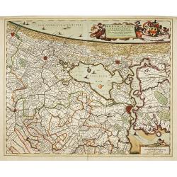
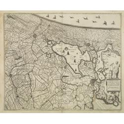
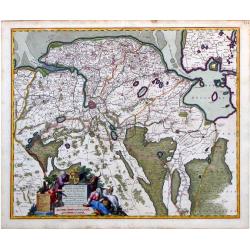
Rhenolandia, Amstelandia et Circumjacentia aliquot Territoria, cum Aggeribus omnibus Terminisq . . .
Decorative folio map of the region surrounding Amsterdam orientated with north to the right edge, encompassing Haarlem, Leiden, The Hague and Gouda. Blank on verso. Certa...
Place & Date: Amsterdam, c.1678
Selling price: $300
Sold in 2012
Limburgi Ducatus et Comitatus Valkenburgi. . .
The map describes the southern part of Limburg and reaches into Belgium (Liege, Verviers) and Germany (Aachen). It has two very decorative cartouches.
Place & Date: Amsterdam, 1680
Selling price: $250
Sold in 2018
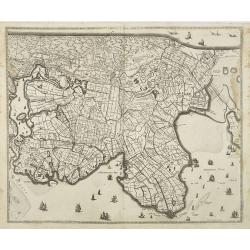
Rhenolandia, Amstelandia..
West to the top. Including towns of Amsterdam, Weesp, Gouda, Den Haag and Leiden. Very decorative title cartouche with dedication to Johan Hudde, senator of Amsterdam.
Place & Date: Amsterdam 1680
Selling price: $760
Sold

Tabulae Dominii Groeningae..Partem Drentiae..
A fine engraved 17th century map of Groningen. Decorative title cartouche surmounted by coat of arms and two figures. Title cartouche with putti, figure and animals. Comp...
Place & Date: Amsterdam 1680
Selling price: $380
Sold
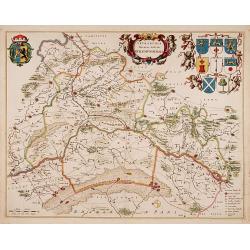
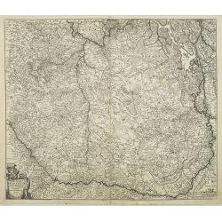
Ducatus Brabantiae Continens Marchionatum Sacri Imperii..
Shows present-day Belgium and Dutch province of Brabant. Including the Maas and Waal rivers. Shows Antwerp, Brussels, Namur, Liege and Venlo among other towns and cities....
Place & Date: Amsterdam 1680
Selling price: $400
Sold
Tabula Comitatus Frisiae.
The map was prepared by B.Schotanus à Steringa.
Place & Date: Amsterdam 1680
Selling price: $400
Sold
Ultraiectini Dominii Tabula..
Orientated south to the top. With two very decorative cartouches etched by Mr. Romeijn de Hooghe.
Place & Date: Amsterdam, 1680
Selling price: $550
Sold in 2008
Belgium Foederatum emendate auctum et novissime editum.
Fine detailed map of the area of the modern Netherlands less the southern part of Limburg. Title cartouche representing the commerce, the arts and the sciences. The Lion ...
Place & Date: Amsterdam, 1680
Selling price: $900
Sold in 2010
Novissima et accuratissima XVII Provinciarum Germaniae. . .
Showing present-day The Netherlands, Belgium, and Luxembourg. West to the top. Great cartouche. An interesting explanation is that Dr. Iohanni Munter was consulted in the...
Place & Date: Amsterdam, 1680
Selling price: $650
Sold in 2008
Comitatus Zelandiae tabula emendata a Frederico de Wit amstelodami.
Fine map covering Zeeland. Fine title cartouche and extensive shipping on Westerschelde and other waterways. Shows five islands: Walcheren, Schouwen, Duyvelant, Noort Bev...
Place & Date: Amsterdam, 1680
Selling price: $275
Sold in 2009

Novissima Delflandiae, Schielandiae et circumiacentium insularum ut Voornae, Overflackeae Goerea, Iselmondae aliarumque tabula Auctore Balthazaro Florentio a Berckenrode Amstelodami. Apud Fredericum De Witt.
A very nice map showing the southern part of the province of Holland, prepared by B.F. Van Berckenrode.Originally the plate was published by Janssonius. This is the much ...
Place & Date: Amsterdam, 1680
Selling price: $245
Sold in 2009
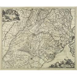
Rhinolandiae, Amstelandiae et circumiacent. Aliquot territor . . .
Map centered on The Hague, Leiden, Haarlem, Amsterdam, Gouda, etc. West to the top. Prepared by Balthasar Floris van Berkenrode.BR>Originally the plate was published b...
Place & Date: Amsterdam, 1680
Selling price: $250
Sold in 2009
Noordt Hollandt.
A detailed map of the northern part of Holland. At that time practically all polders -with the exception of the IJ-polder- had already been reclaimed.
Place & Date: Amsterdam, 1680
Selling price: $100
Sold in 2009

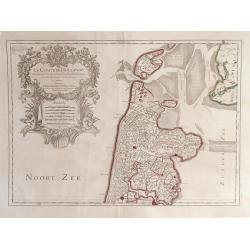
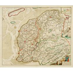
Nova atque emendata descriptio Suydt Hollandiae edita a Frederico de Wit.
A detailed map of the southern part of Holland with the cities of Breda, Dordrecht and Gorinchem. The map is oriented with west at the top. Superb detail of roads, canals...
Place & Date: Amsterdam, 1680
Selling price: $200
Sold in 2009
Tabula Ducatus Brabantiae continens Marchionatum Sacri Imperii et Dominium Mechliniense emendate à F. de Wit 1666
Shows present-day Belgium and Dutch province of Brabant. Including the Maas and Waal rivers. Shows Antwerp, Brussels, Namur, Liege and Venlo among other towns and cities....
Place & Date: Amsterdam, 1680
Selling price: $85
Sold in 2012
Ultraiectini Dominii Tabula Multo aliis auctior et corrector, per Nic. Visscher.
Orientated south to the top. With two very decorative cartouches etched by Mr. Romeijn de Hooghe. In Latin. Taken from the atlas Germania Inferior, sive XVII Provinciarum...
Place & Date: Amsterdam, 1680
Selling price: $200
Sold in 2009

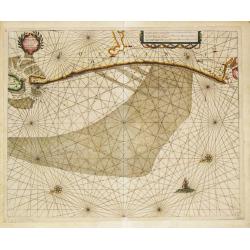
Paskaerte van het inkoomen van de Maes.. (two sheets)
Uncommon chart of the river Maas from the entrance down to the Biesbosch. Including the towns of Dordrecht, Rotterdam, Schiedam, Willemstad, Vlaardingen, Den Briel, Helle...
Place & Date: Amsterdam, ca.1680
Selling price: $1500
Sold in 2009
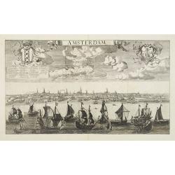
Amsterdam.
Beautiful panoramic town-view Amsterdam seen from the IJ. Extensive shipping in the foreground. Coats-of-arms of the town in top. A label has been pasted underneath the c...
Place & Date: Paris, ca. 1680
Selling price: $700
Sold in 2009
Groningae et Omlandiae dominium vulgo de provincie van Stadt en Lande.
Detailed map of the northern Dutch region of Groningen with figurative cartouche and coats of arms. The town of Groningen in the center, Emden just on the right. Engraved...
Place & Date: Amsterdam, ca. 1680
Selling price: $1300
Sold in 2010