Browse Listings in Europe > Netherlands
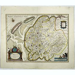
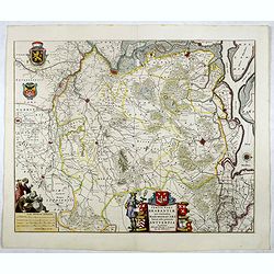
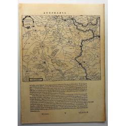
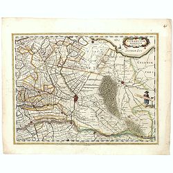
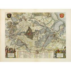
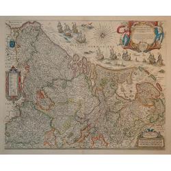
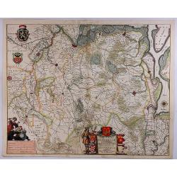
Frisia Occidentalis.
Map of Friesland. The main towns are shown by miniature plan, attractive title cartouche bottom left, key cartouche top right, scale cartouche bottom right.More about map...
Place & Date: Amsterdam, 1645
Selling price: $150
Sold in 2020
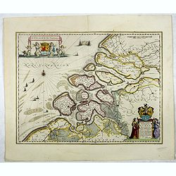
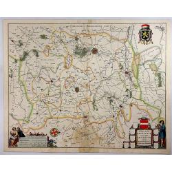
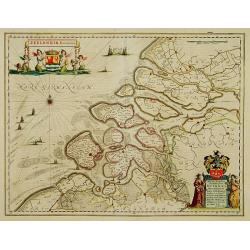
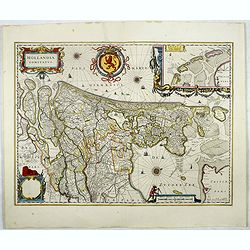
Zeelandia Comitatus.
Standard map of Zeeland with small parts of Holland and Flanders.More about maps by Willem Blaeu. [+]
Place & Date: Amsterdam, 1645
Selling price: $350
Sold in 2017

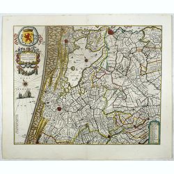
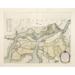
Delflandia, Schielandia.
This finely engraved map by Willem Blaeu shows the estuary of the River Maas and includes the area from 's-Gravenhage to Gouda to Steenbergen and Ouddorp. Includes Rotter...
Place & Date: Amsterdam, 1645
Selling price: $325
Sold in 2021

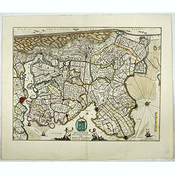
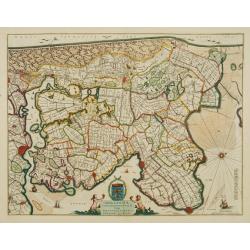
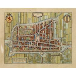
Zuydhollandia stricte sumta.
The count ship of Holland was subdivided into a number of bailiwicks. The most southerly bailiwick, bordering on Brabant was named Zuid-Holland. Many floods changed the a...
Place & Date: Amsterdam, 1645
Selling price: $175
Sold in 2019
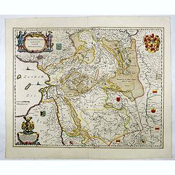
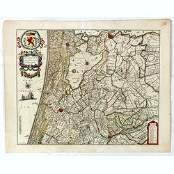
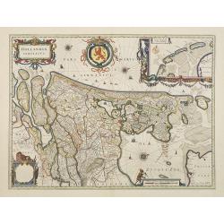
Rhenolandiae et Amstellandiae.
Encompasses the area between 's-Gravenhage and Gouda in the south, to Beverwijk in the north. Large expanse of the Haarlemmermeer occupies the centre of the plate. A very...
Place & Date: Amsterdam, 1645
Selling price: $250
Sold in 2017
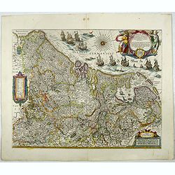
Hollandiae pars septentrionalis, Vulgo Westvriesland..
Based on the work of B.F.van Berckenrode, this fine map, orientated west to the top of the sheet, includes Kennemerland and Hollands Noorderkwartier and is a reasonably u...
Place & Date: Amsterdam, 1645
Selling price: $100
Sold in 2017
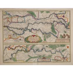
Tractus Rheni et Mosae totusq Vahalis.
Shows that part of the central Netherlands where the three great rivers flow to within but a few kilometers of each below Wesel. The scale allows most of the larger towns...
Place & Date: Amsterdam, 1645
Selling price: $50
Sold in 2017
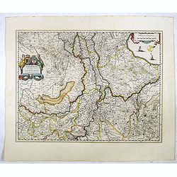
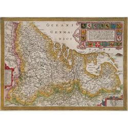
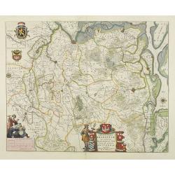
Geldria Ducatus et Zutphania Comitatus.
Map of Gelderland orientated west at the top, including Northern Limburg, eastern part of Brabant, Veluwe and Zutphen. Including the towns of Utrecht, Enschede, Rhunbeck,...
Place & Date: Amsterdam, 1645
Selling price: $50
Sold in 2018
Novus XVII Inferioris Germaniae Provinciarum Typus.
One of the most decorative maps of present Netherlands, Belgium and Luxembourg.With the signature of "Willem Blaeu op't Water in de Vergulde Zonnewyzer."Superb ...
Place & Date: Amsterdam, 1645
Selling price: $750
Sold in 2017
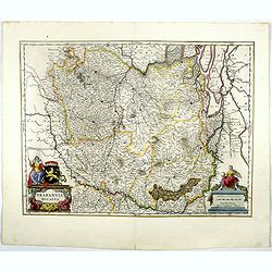
Brabantia Ducatus.
West is at the top. On the lower left a magnificent cartouche with a sitting female figure carrying a globe and compasses and the coat of arms of Brabant. The map enclose...
Place & Date: Amsterdam, 1645
Selling price: $250
Sold in 2018
Tertia Pars Brabantiae.
West is at the top. At the lower left the cartouche embellished with male figures with compasses, globe, book and winckel-kruis . At bottom, right of the centre, a beauti...
Place & Date: Amsterdam, 1645
Selling price: $150
Sold in 2019

Drentia Comitatus.
Attractive figured cartouche top left, scale cartouche illustrative of the peat digging in the region bottom left.More about maps by Willem Blaeu. [+]
Place & Date: Amsterdam, 1645
Selling price: $170
Sold in 2017
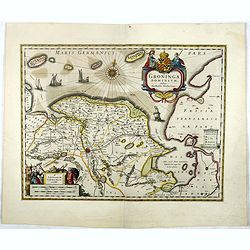
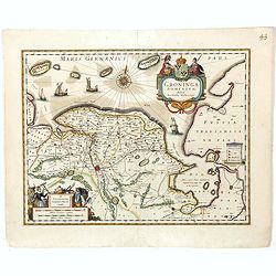
Groninga Dominium.
This finely proportioned, well-designed map was made by the Groningen patrician Barthold Wichering in 1616. An impressive title cartouche top right: key on plinth right c...
Place & Date: Amsterdam, 1645
Selling price: $60
Sold in 2017
Ultraiectum Dominium.
Highly detailed map of Utrecht and its surroundings of The Netherlands.More about maps by Willem Blaeu. [+]
Place & Date: Amsterdam, 1645
Selling price: $60
Sold
Transiselania Dominium vernacule Over-Yssel.
Map of Overijssel and Drente. Oriented west at the top of the sheet. More about maps by Willem Blaeu. [+]
Place & Date: Amsterdam, 1645
Selling price: $150
Sold in 2017
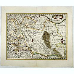
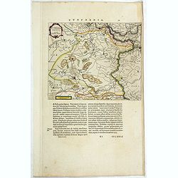
Zutphania Comitatus...
A nice map of the county of Zutphen in Gelderland. The map shows the eastern part of the province as well as a small part of Germany. Important cities named are Arnhem, N...
Place & Date: Amsterdam, 1645
Selling price: $16
Sold in 2019
Prima Pars Brabantiae Cuius Caput Louanium.
A striking map showing the region of Loewen in the Duchy of Brabant in the Netherlands. Loewen and Tienen are shown prominently in the centre of the map. Inside the map a...
Place & Date: Amsterdam, 1645
Selling price: $100
Sold in 2018
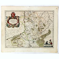
Ducatus Limburgum.
Decorative map of Belgium that is centered roughly on the Meuse River (Latin Mosa) and its cities of Hoy, Liege, and Maastricht. Finely detailed to show numerous towns an...
Place & Date: Amsterdam, 1645
Selling price: $100
Sold in 2019
Rhenolandiae et Amstellandiae.
Encompasses the area between 's-Gravenhage and Gouda in the south, to Beverwijk in the north. Large expanse of the Haarlemmermeer occupies the center of the plate. A very...
Place & Date: Amsterdam, 1645
Selling price: $210
Sold in 2019
Ultraiectum Dominium.
Based on the map by B.F.van Berckenrode (1620-21). A highly detailed map of Utrecht and its surroundings of The Netherlands. From a German edition of Blaeu's atlas.From e...
Place & Date: Amsterdam, 1645
Selling price: $125
Sold in 2019
Groninga Dominium.
This finely proportioned, well-designed map was made by the Groningen patrician Barthold Wichering in 1616. An impressive title cartouche top right: key on plinth right c...
Place & Date: Amsterdam, 1645
Selling price: $150
Sold in 2019

Delflandia, Schielandia.
This finely engraved map shows the estuary of the River Maas and includes the area from 's-Gravenhage to Gouda to Steenbergen and Ouddorp. Includes Rotterdam and Delft: G...
Place & Date: Amsterdam, 1645
Selling price: $140
Sold in 2019
Hollandiae pars septentrionalis, Vulgo Westvriesland..
Based on the work of B.F.van Berckenrode, this fine map, orientated west to the top of the sheet, includes Kennemerland and Hollands Noorderkwartier and is a reasonably u...
Place & Date: Amsterdam, 1645
Selling price: $110
Sold in 2019
Hollandiae pars septentrionalis, Vulgo Westvriesland en 't Noorder Quartier.
Based on the work of B.F.van Berckenrode, this fine map, orientated west to the top of the sheet, includes Kennemerland and Hollands Noorderkwartier and is a reasonably u...
Place & Date: Amsterdam 1647
Selling price: $500
Sold
Zeelandia Comitatus.
Map of Zealand with title and coat of arms of Zeeland at top left. At bottom right a dedication in the cartouche by W.Blaeu to Simon van Beaumont. The map shows Zeeland a...
Place & Date: Amsterdam 1647
Selling price: $776
Sold
Hollandiae pars septentrionalis, Vulgo Westvriesland..
Based on the work of B.F.van Berckenrode, this fine map, orientated west to the top of the sheet, includes Kennemerland and Hollands Noorderkwartier and is a reasonably u...
Place & Date: Amsterdam 1647
Selling price: $350
Sold
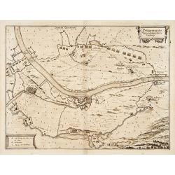
Tabula Castelli ad Sandflitam, ..Bergas ad Zomam et Antverpi
East is at the top. The map pictures the complex military situation that had developed after the Dutch blockade of Antwerp. All entrenchment's and fortresses marked by a ...
Place & Date: Amsterdam 1647
Selling price: $350
Sold in 2008
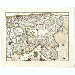
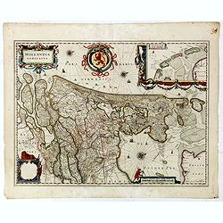
Hollandia Comitatus.
Orientated west to the top of the sheet, this represents the County of Holland in the classical orientation for seventeenth century maps, with Amsterdam at the centre. Th...
Place & Date: Amsterdam, 1647
Selling price: $1950
Sold in 2009
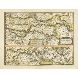
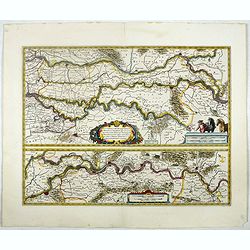
Descriptio fluminum Rheni, Vahalis et Mosae.
Shows that part of the central Netherlands where the three great rivers flow to within but a few kilometers of each below Wesel. The scale allows most of the larger towns...
Place & Date: Amsterdam, 1647
Selling price: $250
Sold in 2018
Tractus Rheni et Mosae totusq Vahalis.
Shows that part of the central Netherlands where the three great rivers flow to within but a few kilometers of each below Wesel. The scale allows most of the larger towns...
Place & Date: Amsterdam, 1647
Selling price: $50
Sold in 2016
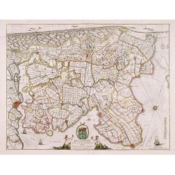
Hollandia Comitatus.
Orientated west to the top of the sheet, this represents the County of Holland in the classical orientation for seventeenth century maps, with Amsterdam at the centre. Th...
Place & Date: Amsterdam, 1647
Selling price: $600
Sold in 2017
Zutphania Comitatus.
Detailed map of the area "Zutphania" includings the cities of Zutphen, Arnhem, Emmerich, and Deventer. South to the top. More about maps by Willem Blaeu. [+]
Place & Date: Amsterdam, 1647
Selling price: $50
Sold in 2017
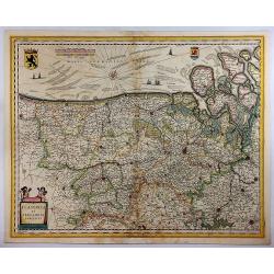
Flandria et Zeelandia Comitatus.
A decorative, large map including Flanders and Zeeland. The map was originally engraved, in 1641, for Sanderus 'Flandria Illustrata', and was used at different times in B...
Place & Date: Amsterdam, 1647
Selling price: $95
Sold in 2018
Hollandia Comitatus.
Orientated west to the top of the sheet, this represents the County of Holland in the classical orientation for seventeenth century maps, with Amsterdam at the center. Th...
Place & Date: Amsterdam, 1647
Selling price: $100
Sold in 2019
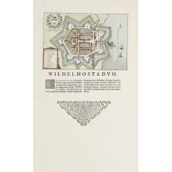
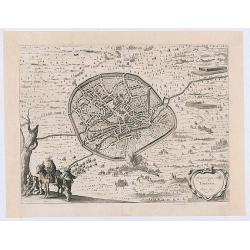
Willemstad.
Plan of the Brabant town "Willemstad" from Blaeus townbooks of the Netherlands. Latin text underneath desribing the foundation of the town by William of Orange...
Place & Date: Amsterdam 1648
Selling price: $75
Sold

s-Gravensande, Vlaardingen.
Two plans from Blaeus townbooks of the Netherlands. Plan of the town s-Gravensande in the now-a-days province "Zuid Holland". Plan of the town Vlaardingen in...
Place & Date: Amsterdam 1648
Selling price: $150
Sold

Lugdunum Batavorum - Leyden in Hollant
Nice hand-colored copper engraving picturing the city of Leiden. The 1648 edition of Guicciardini's famous work Description of the Netherlands was issued by J. Janssonius...
Place & Date: Amsterdam 1648
Selling price: $600
Sold
Amstelredam
Nice handcolored copper engraving picturing the city of Amsterdam. From the 1648 edition of Guicciardini's famous work Description of the Netherlands issued by J. Jansson...
Place & Date: Amsterdam 1648
Selling price: $500
Sold
Belgicarum Provinciarum Nova Descriptio
Beautifully handcolored copper engraving picturing the Netherlands 17 Provinces. From the 1648 edition of Guicciardini's famous work Description of the Netherlands issued...
Place & Date: Amsterdam 1648
Selling price: $650
Sold
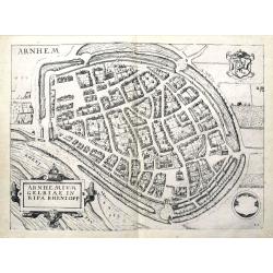
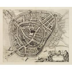
Arnhemium Gelriae in Ripa Rheni Opp.
A bird's eye view plan of Arnhem, Gelderland. After Lodovico Guicciardini by J. Janssonius. Filled with buildings and details. With the coat of arms and a title cartouche...
Place & Date: Amsterdam, 1648
Selling price: $30
Sold in 2019
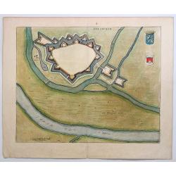
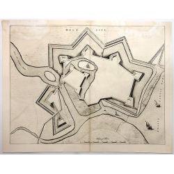
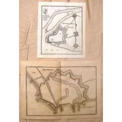
Gravia obsessa et expugnata armis ordinum Belgicae..
A military map showing Grave and the surrounding area with fortifications. With a decorative title cartouche, a blank cartouche with two figures and a military scene vign...
Place & Date: Amsterdam 1649
Selling price: $200
Sold
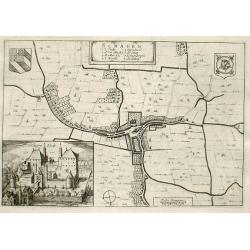
Schagen
Fine map of the town of Schagen with inserted a nice engraving of the Castle of Schagen.Copper engraving from Joan Blaeu's Toneel der Steden (townbook) 1649.Dutch text on...
Place & Date: Amsterdam 1649
Selling price: $110
Sold
Breda Obsessa Et Expugnata a Celsissimo Friderico Henrico.
Fine map of Breda and environs to show the siege of the town by Frederik Hendrik, Prince of Orange, in 1637. Lower left a decorative cartouche with a dedication and coats...
Place & Date: Amsterdam, 1649
Selling price: $1500
Sold in 2013
Amisfurtum. (Amersfoort)
A bird's-eye view of the town.
Place & Date: Amsterdam 1649
Selling price: $400
Sold
Delfi Batavorum vernacule Delft.
Detailed plan of the city Delft from Joan Blaeu\'s town book of the Netherlands, first published one year after the peace of Munster and the Spanish acknowledgement of th...
Place & Date: Amsterdam, 1649
Selling price: $2200
Sold in 2010
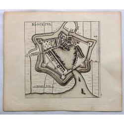
Blockzyl.
Birds-eye view of Blokzijl and it's fortifications by Blaeu. Blokzijl is a city located southwest of Steenwijk in the province of Overijssel, the Netherlands. Blokzijl gr...
Place & Date: Amsterdam, c1649
Selling price: $10
Sold in 2018
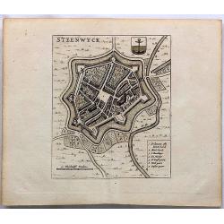
Steenwyck.
Fine birds-eye view of the fortified town of Steenwijk in the province of Overijssel, the Netherlands. Steenwiik grew in the 1580s. During the siege of Steenwijk, the...
Place & Date: Amsterdam, ca.1649
Selling price: $19
Sold in 2023
Gravia Obsessa et Expugnata Armis Ordinum Belgicae Confoederate.
A military map showing Grave, Brabant,Netherlands and the surrounding area with fortifications. featuring a decorative title cartouche, a blank cartouche with two figures...
Place & Date: Amsterdam, 1649
Selling price: $75
Sold in 2019
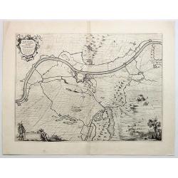
Stenovicum Obsessa ab Ordinibus Belgiae Foederatae.
Striking map of the siege of Steenwijk by Maurice in 1592.. Copper engraving, produced in 1649 in Amsterdam by Joan Blaeu from “Novum ac Magnum Theatrum Urbium Belgicae...
Place & Date: Amsterdam, 1649
Selling price: $12
Sold in 2018
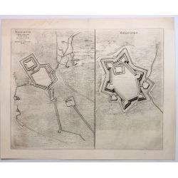
Brefurtum Capta Anno 1597 / Breevoort. (Bredevoort)
Plans of Breedevoort from the Townbook "Theatrum Urbium Belgicae" by Blaeu. Bredevoort is in the province of Gelderland in the Netherlands.Two engravings on one...
Place & Date: Amsterdam, 1649
Selling price: $17
Sold in 2023
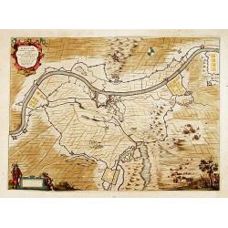
Doesburgh.
A nicely colored town plan of Doesburg in northeastern Holland, shown in an unusual panoramic birds-eye view, circa 1649. It features the fortress walls and a few cottage...
Place & Date: Amsterdam, 1649
Selling price: $37
Sold in 2019
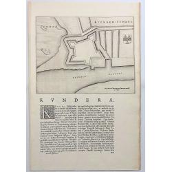
Kuynder-Schans.
Also known as “Kaart van de schans van Kuinre”. Kuinre is a village in the Dutch province of Overijssel located on the Zuyder Zee.It was a separate municipality until...
Place & Date: Amsterdam, 1649
Selling price: $7
Sold in 2018
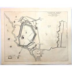
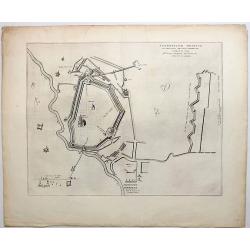
Stenovicum Obessa Ab Ordinibus Belgiae Foederatae...
A detailed map of the Siege of Steenwijk by Maurits in 1592. Steenwijk is located in the northern corner of the province of Overijssel, bordering on the Zuyder Zee, calle...
Place & Date: Amsterdam, 1649
Selling price: $46
Sold in 2019
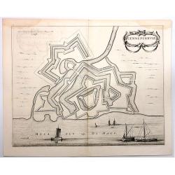
Genneperhuis.
Genneperhuis was a fortress at the mouth of the Niers River, near the town of Milsbeek, in the Dutch province of Limburg.This was the location of the Siege of the Gennepe...
Place & Date: Amsterdam, 1649
Selling price: $16
Sold in 2018
Delfsill.
A plan of the town of Delfzijl, on the northern coast of Holland, shown in a panoramic birds-eye view. It features the walls of the fortress, but only one single church w...
Place & Date: Amsterdam, 1649
Selling price: $16
Sold in 2018
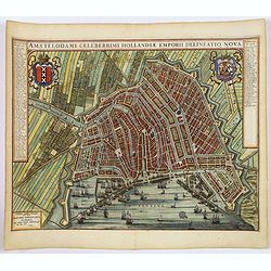
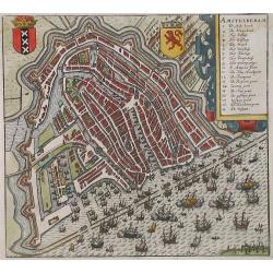
(Amsterdam)Amstelodami Celeberrimi Hollandiae Emporii delineatio nova.
A very attractive bird's-eye view of this most important European city, engraved at the height of the 'Golden Age' of Dutch cartography, when it sat at the hub of one of ...
Place & Date: Amsterdam, 1649
Selling price: $1750
Sold in 2019
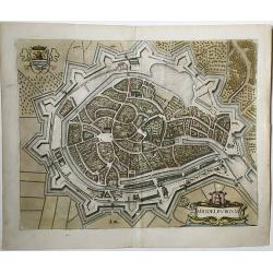
Middelburgum.
A fine city map in the style of a bird's eye of the city of Middelburg in Zeeland, Netherlands. Published in 1649 by Joan Blaeu in his 'Toonneel der Steden der Veenigde N...
Place & Date: Amsterdam, 1649
Selling price: $165
Sold in 2021
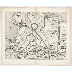
La siege de Hulst Per Son Altesse la Prince dOrangie 1645. / De belegeringe van de stadt Hulst.
This map of Hulst shows the siege and capture of the city in 1645 by a Dutch army led by Frederik Hendrik. The emphasis is on the siege machines surrounding the city. The...
Place & Date: Amsterdam, 1649
Selling price: $100
Sold in 2021
Belägerung des Vesten.. Gennep.
Detailed map of the siege of Gennep.
Place & Date: Frankfurt 1650
Selling price: $90
Sold
Novus XVII Inferioris Germanie Provinciarum Typus
This is undoubtedly one of the most magnificent maps of the seventeen provinces of the Netherlands. It was first produced as a separately issued wall map in 1608 with fig...
Place & Date: Amsterdam, 1650
Selling price: $1500
Sold in 2010
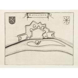
Ravenstein.
A bird's eye view engraving of the Dutch city of Ravenstein.Latin text on verso.
Place & Date: Amsterdam 1650
Selling price: $35
Sold

Rotterdam.
Decorative plan of Rotterdam. With extensive shipping on foreground. Very decorative and of the highest standing of engraving.
Place & Date: Frankfurt, 1650
Selling price: $375
Sold in 2009
Tertia Pars Brabantiae.
West is at the top. At the lower left the cartouche embellished with male figures with compasses, globe, book and winckel-kruis . At bottom, right of the centre, a beauti...
Place & Date: Amsterdam, 1650
Selling price: $450
Sold in 2009
Tertia Pars Brabantiae. . .
A striking map showing part of present-day Belgium and Dutch Brabant. West is at the top. At the lower left the cartouche is embellished with male figures with compasses,...
Place & Date: Amsterdam, 1650
Selling price: $200
Sold in 2018

Afbeeldinge Vande vermaerde Seehaven ... Duynkerken...
A striking coastal chart, extending from Dunkerque and Wynoxbergen to in the east to Waldarn and Gravelines in the west, with an inset showing the continuation of the coa...
Place & Date: Amsterdam, 1650
Selling price: $48
Sold in 2018
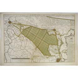
Afbeeldinge van Zeker Concept tot Bedykinge, van de Haarlemer, Leydse en Andere byleggende Meeren.
Large, rare, and detailed map of the region between Amsterdam, Haarlem and Leiden, from two copperplates. It concerns a concept to reclaiming the Haarlemmermeer, drawn by...
Place & Date: Amsterdam, 1650
Selling price: $275
Sold in 2019
Veroveringe van Thienen Anno 1635
Birds eye view of the conquest of Tienen by the national army led by Frederik Hendrik, 1 June 1635, from : "I. Commelin, Frederick Hendrick van Nassauw Prince van Or...
Place & Date: Amsterdam 1651
Selling price: $25
Sold in 2020
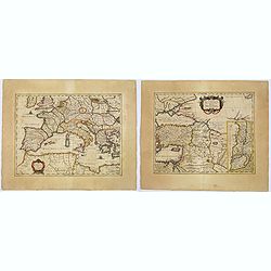
Lumen Historiarum per Occidentem. . . / Lumen Historiarum per Oreintem. . . Lumen Historiarum per Occidentem. . . / Lumen Historiarum per Orientem. . .
A pair of interesting seventeenth-century maps. The first map is an unusual 1652 map of Europe as known to the ancients by Jan Jansson. Centered on Italy, this map covers...
Place & Date: Amsterdam, 1652
Selling price: $160
Sold in 2018
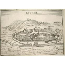
Lochem.
Nice bird's-eye view of the town of Lochem in central part of the province of Gelderland.Very detailed engraving, with the Lochemer berg in the background.Made by Nicolaa...
Place & Date: Arnhem 1653
Selling price: $150
Sold
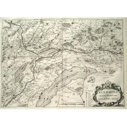
Ruermond, Het Over Vierdeel van Gelderlandt
Rare map of the southern part of the former duchy of Gelre, now a part of the Dutch province of Limburg. The map shows the area of Northern Limburg and the eastern part o...
Place & Date: Arnhem 1653
Selling price: $425
Sold
Ollandt.
A fine miniature map of Holland, including a sea-monster and several sailing ships. The map was published by Pietro Marchetti in his Il Theatro del Mondo, an Italian pir...
Place & Date: Venice, ca. 1655
Selling price: $75
Sold in 2019
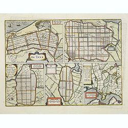
De Zype./ Purmer/ Wormer/ Beemster/ Waterland.
Five maps on one sheet. Showing the polders of De Zype, De Purmer, De Wormer, De Beemster and a map of Waterland, including de Bylmermeer and Monnekedam. Showing the Noor...
Place & Date: Amsterdam, 1652-1658
Selling price: $110
Sold in 2011
Gertruydenberg and Vlissingen (Flushing)
Striking city plans of Gertruydenberg by Caspar Merian in 1659. Caspar Merian (1627-1686) was one of the most important topographical engravers and publishers of the Ba...
Place & Date: Frankfurt am Main, 1659
Selling price: $10
Sold in 2016
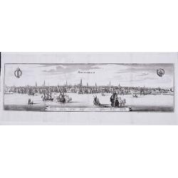
Amsterdam.
A panoramic view of the town from 't IJ.
Place & Date: Frankfurt, 1659
Selling price: $375
Sold in 2021

Pas Caert van Texel tot aen de Hoofden.
An attractive chart of the North Sea. Hendrick Doncker was one of the leading Amstrdam-based publshers of sea-atlases and sea charts
Place & Date: Amsterdam, 1659
Selling price: $650
Sold in 2023
![Harlemum vulgo Haerlem. [Haarlem]](/uploads/cache/15745-250x250.jpg)
Harlemum vulgo Haerlem. [Haarlem]
Fine plan of Haarlem. Lower left a numbered key (1-67).From JANSSONIUS RARE town book of the Netherlands. Copied after the plan of Blaeu, but much rarer.
Place & Date: Amsterdam 1660
Selling price: $400
Sold

Schoonhoven.
A bird's eye view of the town of Schoonhoven. With short key list inside the title cartouche.Latin text on verso.
Place & Date: Amsterdam, 1660
Selling price: $95
Sold in 2010
![[Waterland, Purmer, and Bijlmer] Kaarte vande Buycker-slooter, Broecker ende Belmer Meeren in Water-land Gemeten door Mr. SN Boonacker. . .](/uploads/cache/11504-250x250.jpg)
[Waterland, Purmer, and Bijlmer] Kaarte vande Buycker-slooter, Broecker ende Belmer Meeren in Water-land Gemeten door Mr. SN Boonacker. . .
Five maps on one sheet. Showing the polders of De Zype, De Purmer, De Wormer, De Beemster and a map of Waterland, including de Bylmermeer and Monnekedam. Showing the Noor...
Place & Date: Amsterdam, 1660
Selling price: $300
Sold in 2019
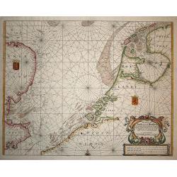
Pas Caert van Texel tot aen de Hoofden.
Very scarce and handsome sea chart of the coast of Friesland to France and at the other side of the Channel, England. It is richly embellished with rhumb lines, a half co...
Place & Date: Amsterdam, 1660
Selling price: $1200
Sold in 2008
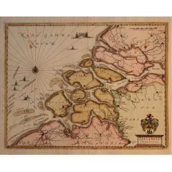
Zeelandia Comitatus.
Map of the Province of Zeeland, with its many islands and peninsulas. Major cities, small villages, and some of the natural features are named. Development over time has ...
Place & Date: Francfurt, 1660
Selling price: $160
Sold in 2009